Washington Governor, “Everything we need to fight forest fires is in dire need across the Western United States”

Multiple governors asked President Biden for aerial assets, firefighters, help in obtaining aviation fuel, and aggressive initial attack

Air resources on the Cedar Creek Fire
Aviation resources on the Cedar Creek Fire in Washington, July 29, 2021. InciWeb.

Friday President Biden hosted his second virtual meeting to discuss wildfire preparedness. This session was with the Governors of three western states, Montana, Washington, and California. The earlier meeting on the topic was June 22, 2021.

The Governors told Mr. Biden that their states need more aviation resources, they need help with obtaining aviation fuel, they need more boots on the ground, and they encourage aggressive initial attack.

“Everything we need to fight forest fires is in dire need across the Western United States,” said Governor Jay Inslee of Washington.

These requests, coming from multiple states in late July with the meat of the fire season still possibly on the horizon, are astonishing.

The President began the meeting with a few remarks before asking the three Governors what the Federal government could do to help.

“Our resources are already being stretched to keep up,” Mr. Biden said.  “We need more help, particularly when we also factor in the additional nationwide challenges of pandemic-related supply chain disruptions and our ongoing efforts to fight COVID. We’ve had a few COVID clusters at our fire camps, which further limits resources.  It’s just one more reason why it’s so darn important that everyone get vaccinated, I might add. Sadly, we’ve also lost two brave firefighters in the last month in a plane crash in Arizona, and five were seriously injured last week battling the Devil’s Creek fire in Montana. It’s — to state the obvious, and you governors know it better than anybody — it is really, really dangerous work, and it takes incredible bravery to do it.  And these heroes deserve to be paid — and paid well — for their work.  That’s why, last month, I was able to announce — and it’s not paying that well, in my view, to be honest with you — immediate action to make all federal firefighters making at least $15 an hour.  I think they deserve more than that. We’re also working with Congress to make sure that our firefighters are paid better permanently.  Permanently.”

Governor Greg Gianforte of Montana was called on first. He spoke briefly, saying that aggressive initial attack was important. “Without that commitment,”Governor Gianforte said,  “we would have had many more large scale fires. And we ask that our federal partners join us in applying this operating principle. Whether it’s a fire that starts on private, state, or federal land — fires are easier to manage when they’re smaller.”

Governor Gianforte then went on to talk about active forest management.

Below are quotes from the other two Governors.

Governor Jay Inslee, Washington

My biggest concern might surprise you because all of the governors share these immediate concerns.  We have a huge need for additional aerial assets, additional dozer bosses so we can get our dozers into fire lines.  We need new tra- — more trained people.  We do have an emerging concern about our fuel supply for our aerial assets.  Everything we need to fight forest fires is in dire need across the Western United States, not just in Washington State.  We’ve had a thousand fires.  It’s burned four times more at this time of year than normal.  We’ve had two and a half times more acreage burn in the last decade than the previous.

Governor Gavin Newsom, California

Look, I just want to briefly — because there’s so many of us — a quick update.  We’re blowing past every record, and not in a good way.  We’re at over 5,700 fires year-to-date.  We suppressed 59 just yesterday with some initial attacks.  Over half a million acres already burned in California. To put in perspective — a record-breaking year.  Last year, we were at 130,000 acres burned.  We’re at 504,000 as I speak to you today.

Here’s the answer to your question.  And forgive me for being so pointed again, respecting your time, but I want to be a little bit more specific. Jay referenced it obliquely.  Please pay attention to this fuels issue.  We had to get our National Guard to get some emergency fuel supplies for our aerial fleet a week ago.  This is a major issue, and it’s not just impacting our aerial suppression strategies on the West Coast.  It’s increasingly, as you may know, impacting commercial aviation.  It is a major issue.

Number two, we just simply need more boots on the ground.  We can’t do without you.  We’ve got 7,400 people — 7,400 already.  We’re not in fire season.  Fire season in California is late September, October, into November.  We’re in July.  We already have 7,400 personnel actively working to suppress fires. Last year, the federal government asked us for over 5,000 mutual aid support that we could not provide.  That gives you a sense of what the federal government wanted from California last year to send to other states.  That should give you a sense of how far behind we are with federal support.

We have four DC-10s, Mr. President.  Four.  Now, DC-10s aren’t the answer to every problem.  They don’t fly over 35 knots.  They have restrictions; there are legendary restrictions.  But the reality is there is four for the country, and we’re competing.  They’re all contracted.  We compete with you.  We compete with other states.  We don’t even have access right now to DC-10s. We lost that 747 — that iconic 747 — that now has been converted to a cargo plane.  You’ve seen that in Australia, not just across the West Coast.  That’s now been grounded by a private contractor.

We are the largest civil aviation fleet for firefighting in the world — California.  We do not come close to having the tools in the air that we need.  We need your support to su- — to dramatically increase the aerial support, in addition to boots on the ground.

But here’s the final thing, and it’s the elephant in the room.  I was with Governor Sisolak two days ago in his state of Nevada.  The reason why is we had a fire that was on federal property.  Fifty-seven percent of the forest property in California is federal, just three percent under California jurisdiction.  Three percent.  Fifty-seven percent under U.S. Forest Service.  U.S. Forest Service is spectacular.  We have deep admiration and respect, but there’s a culture that, too often, is, “Wait and see.”  We can’t afford that any longer.  This was a federal fire.  They waited.  And what we saw is the fire took off because we didn’t put enough initial assets.

Greg was making an oblique point here.  I want to be a little bit more explicit: We need your help to change the culture, in terms of the suppression strategies, in this climate, literally and figuratively, to be more aggressive on these federal fires. That fire bled into Nevada and, obviously, impacted not just our two states, but deeply impacted the redundancy of this concern that comes out every year around jurisdictions and incident command and the imperative that we’re all on the same page, in terms of those initial attack strategies.

Satellite photo, wildfires in the Northwest, July 29, 2021

Satellite photo smoke wildfire
Satellite photo 7:10 p.m. PDT July 29, 2021

The wildfires in Southeast British Columbia, Northern Washington, Northern Idaho, and Northwest Montana were putting up a lot of smoke Thursday at 7:10 p.m. PDT. NASA GOES 17.

Two fires in Okanogan County Washington have burned a total of 87,000 acres

Cub Creek 2 Fire and Cedar Creek Fire

Cedar Creek Fire, July 18, 2021
Cedar Creek Fire, July 18, 2021. InciWeb.

Two fires in north-central Washington that started the week of July 11 have burned a total of 87,000 acres in Okanogan County. Both are being managed by Type 1 Incident Management Teams. A map of evacuations in effect is at the County’s website. Highway 20 is likely to be closed through the end of July. (Current state highway conditions.) Both blazes are in steep, difficult to access terrain with heavy dead and down fuel loading.

A Smoke Blog has been established to provide information about current and predicted smoke and air quality conditions in Washington.

A heat advisory is in effect for Winthrop Thursday through Saturday for high temperatures near 100 each day. The wind at the city on Thursday and Friday will be generally from the south-southeast at 6 to 8 mph with humidity in the mid-teens. It will be cooler at the fires since Winthrop is at 1,800′ and the terrain on the fires ranges from 2,000′ to over 5,000′. Sunday will bring lower temperatures, humidity around 50 percent, and a 30 percent chance of thundershowers.

Cedar Creek Fire
This lightning-caused fire on the Okanogan-Wenatchee National Forest south of Highway 20, three miles west of Winthrop was mapped July 28 at 35,685 acres. Wednesday it was very active near the head of Little Wolf Creek moving southwest through heavy fuels. It burned past the end of the dozer line that was being built to connect to Thompson Ridge.

The fire is backing down into Little Boulder Creek, Little Falls Creek, and Silver Star Creek.

Map of the Cedar Creek & Cub Creek 2 Fires
Map of the Cedar Creek & Cub Creek 2 Fires. The white lines were the perimeters on July 28. The red dots represent heat detected by a satellite at 2:28 a.m. PDT July 29, 2021.

Cub Creek 2 Fire
This fire 5 miles north of Winthrop has burned 52,832 acres on lands protected by Okanogan County Fire District 6, Washington Department of Natural Resources, and the Okanogan-Wenatchee National Forest. The cause is under investigation.

On Wednesday firefighters worked to tie in multiple hand lines, dozer lines, and existing road systems on the western and eastern flanks.  The smoke reduced the potential for significant fire growth, but the hot and dry temperatures allow it to keep burning in the lower drainages. Crews completed a strategic burning operation along Deer Creek and Sweet Grass Butte. With a significant warming trend beginning Thursday, the top priority for crews is to reduce any heat and fuels on the southeastern flank of the fire, especially near Ramsey  and Tripod Creeks.

Quick summary of wildfires in Washington and Oregon

GOES 17 satellite photo, wildfires, 6:36 p.m. PDT July 18, 2021

There are at least five large significant wildfires currently burning in Washington and Oregon. Here is a quick and dirty summary. The acreages were as of Saturday evening, but all were putting up large smoke plumes Sunday easily seen from a satellite.

Working north to south, starting in Washington:

Cub Creek 2 Fire
4,690 acres, 5 miles north of Winthrop, Washington. Numerous residences are threatened. Evacuations are in effect, including for pack animals, mules from the Okanogan-Wenatchee National Forest who were relocated to their winter pasture.

pack mules on the Oka-Wen

The north flank of the Cub Creek 2 remains unchecked. Retardant from very large air tankers, water scooping planes, and helicopters with buckets are providing support to firefighters in all locations of the fire. It is burning north pushed by diurnal winds during the day and smoke pushed down south during the late evening and morning.

Cedar Creek Fire
4,080 acres, 12 air miles northwest of Winthrop, Washington, very close to Highway 20. The western perimeter of the fire has burned onto a ridgeline with sparse fuels, slowing the spread. On the southern portion of the fire, growth has been minimal as it burns in subalpine areas with minimal vegetation. The northeastern portion remains the most active.

Summit Trail Fire
2,031 acres, 17 miles west of Inchelium. It has only been burning for three days. On Saturday crews continued to build direct fire line. There was fire growth on the north-northwest side of the fire, and crews scouted Upper Ridge Creek Road, developing a plan to prep and hold the fire along the road.

Due to limited resources the fire continued to spread Saturday to the  northeast at a moderate rate of spread, but that pace increased Sunday.

And in Oregon:

Jack Fire
16,764 acres, on both sides of Highway 138, 9 miles northwest of Clearwater. South of Highway 138, firefighters continue burnout operations to build primary line on the west and southwest flanks. On the southeast side, crews will continue to use heavy machinery to clear and brush out roads used as control lines.

Bootleg Fire
298,662 acres, 30 miles northeast of Klamath Falls. The Bootleg Fire continued to push further into Lake County for a distance of five miles on the north side and ten on the east side. It remains about four to five miles north of Highway 140. It was extremely active again on Sunday, as can be seen in the satellite photo above.

Red Apple Fire in Chelan County, Washington prompts evacuations of more than 1,000 residences

It has burned approximately 4,000 acres

6:49 p.m. PDT July 14, 2021

Red Apple Fire
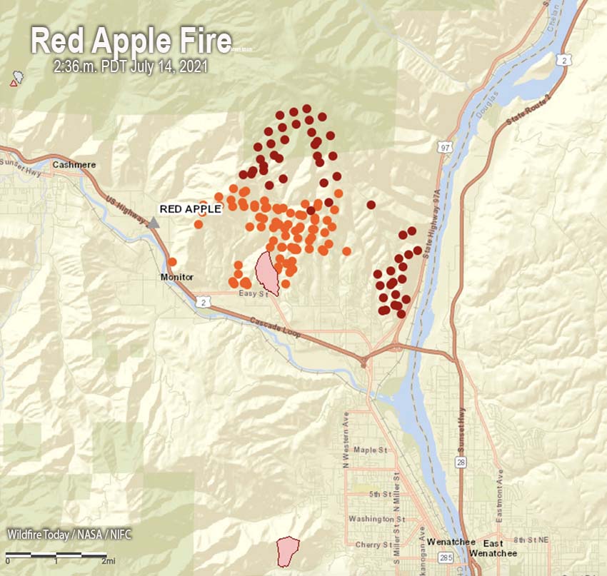
Map showing heat detected by a satellite on the Red Apple Fire as late as 2:36 p.m. PDT July 14, 2021 — the red and orange dots. The dark red dots are the most recent.

The Red Apple Fire in Chelan County, Washington north of Wenatchee has prompted evacuation orders (Leave Now) for 1,065 residences.

The homes being evacuated are in the Sunnyslope area of Wenatchee from Highway 2 and Burch Mountain Road to north of Easy Street and American Fruit Road. We are not aware of reports of any homes being destroyed.

The fire is in the wildland-urban interface where flammable vegetation is near dwellings.

It was reported at about 6:55 p.m. Tuesday near Red Apple Road outside Cashmere. The fire quickly grew overnight and was estimated to be about 4,000 acres Wednesday morning.

The blaze was aggressively attacked Tuesday evening but there was not much daylight left that would allow air tankers and helicopters to drop water or retardant.

Red Apple Fire
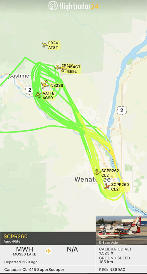
Red Apple Fire. Tanker 260 reloaded many times in the Columbia River and made water drops on the Red Apple Fire. Map produced at 6:09 p.m. PDT July 14, 2021.

On Wednesday afternoon a flight tracking program noted that within a one hour period multiple helicopters and six air tankers were working on the fire including a DC-10 Very Large Air Tanker and two CL-415 scooping air tankers skimming water from the Columbia River.

Thanks and a tip of the hat go out to Carl.

Snake River and Dry Gulch Fires very active in Washington and Idaho

8:30 a.m. MDT July 12, 2021

map Dry Gulch Fire and Snake River Complex
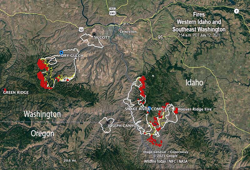
Map of the Dry Gulch Fire and Snake River Complex of fires. The red areas represent heat detected by a satellite at 2:54 a.m. MDT July 12, 2021.

Wildfires are still very active where three states meet, Washington, Oregon, and Idaho.

Dry Gulch
Nearly all of the spread of the fire over the last two days has been on the southwest side. A mapping flight Sunday night found that it had grown to 55,050 acres, but has moved no closer to Lewiston, Idaho and is still 10 miles southwest of the city. The Dry Gulch Fire merged with the Lick Creek Fire on July 8 and they are now treated as one — Dry Gulch.

On Sunday evacuation warnings ( Level 2, get set) were in effect, but no actual evacuation orders (Level 3, leave now). (Very Brief Editorial: We need a national system of evacuation criteria that is uniform across the country, makes sense, and does not require training or explanation!)

Dry Gulch Fire, July 9, 2021.
Dry Gulch Fire, July 9, 2021. InciWeb photo

The Dry Gulch Fire has been managed by a Type 2 Incident Management Team, but a Type 1 Team will assume command Monday, July 12.

Resources assigned on Sunday evening included 14 hand crews, no helicopters, 52 fire engines, and 4 dozers for a total of 536 personnel.

Snake River Complex
The 54,407-acre fire 12 miles south of Lewiston, Idaho is being managed by a Type 2 Incident Management Team. It is comprised of three fires that burned together, Shovel Creek, Captain John Creek, and Hoover Ridge. The growth over the last two days has been closer to each other as well as to the east and the south. It is bordered on the west side by the Snake River. The greatest spread Sunday was on the south side where the Shovel Creek Fire came close to the Salmon River. The east side of the Hoover Ridge Fire is being held by the Salmon River.

Approximately 438 residences are threatened.

From the Incident Management Team Sunday evening:

On the north end of the fire, resources continue to protect values at risk including primary structures and infrastructure around Waha Lake and Red Bird road. Tactics include a combination of indirect line followed up with burning in Madden Creek and around to the south. In the Craig Mountain area, resources are completing indirect fireline to the north. The Hoover Ridge fire resources continue to secure the northeast corner down to the Salmon River. Resources are still using a point protection strategy to burn around and secure values at risk in both the Salmon and Snake Rivers.

Resources assigned Sunday evening included 3 hand crews, no helicopters, and 6 fire engines for a total of 170 personnel.

Dixie Fire
The 15,323-acre Dixie Fire just east of Dixie, Idaho is not being completely suppressed by the Nez Perce-Clearwater National Forest. It is being managed by a Type 1 Incident Management Team. Resources that are 15% monitoring, 30% confining, 35% point protecting, and 20% suppressing the fire include 8 hand crews, 16 fire engines, and 4 helicopters for a total of 522 personnel. The same team is managing the nearby 898-acre Jumbo Fire. (map)