Wildfire potential, April through July

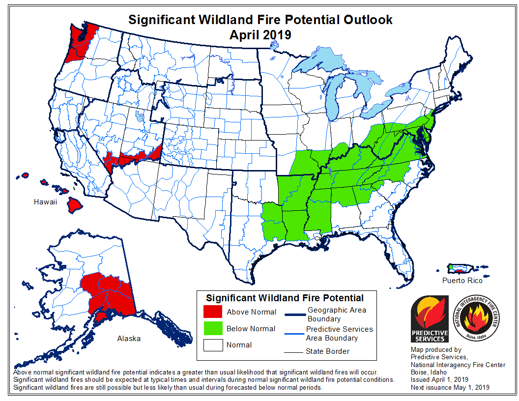
The outlook predicts above normal potential for western Washington and northwest Oregon

April 2019

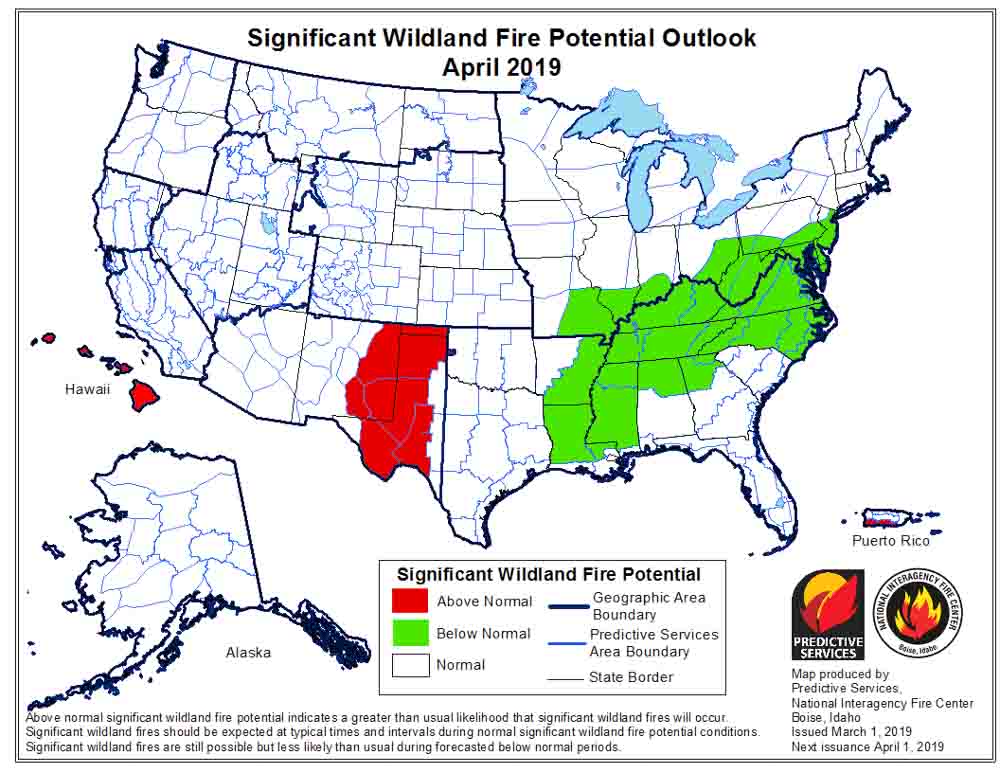
On April 1 the Predictive Services section at the National Interagency Fire Center issued their Wildland Fire Potential Outlook for April through July. The data represents the cumulative forecasts of the ten Geographic Area Predictive Services Units and the National Predictive Services Unit.

If NIFC’s analysis is correct, western Washington and northwest Oregon should see above normal wildfire activity through mid-summer. In June wildfire potential should pick up in the coastal mountains of California while most of the Sierra Nevada Mountains are expected to have below normal activity during those two months.

Below:

  • An excerpt from the NIFC narrative report for the next several months;
  • More of NIFC’s monthly graphical outlooks;
  • NOAA’s three-month temperature and precipitation forecasts; and,
  • Drought Monitor.

“As the spring greenup begins to take hold across the West in April, mountain snowpack will begin to melt. Snowpack melting rates are a more important factor than snowpack levels in assessing potential fire season activity ahead. An average or slower than average melting rate can allow for a late entry of the timbered elevations into the fire season, whereas a faster melting rate will allow for high elevation fuels to become receptive to fire sooner. In 2019, an average to cooler than average spring is expected, so melting rates should be near average which could result in a delayed fire season entry in areas that have abundant snowpack. An early entry is possible along the Canadian border in areas that have a below average snowpack. In the middle and lower elevations, abundant winter and spring moisture should translate to a heavy crop of fine fuels that will become increasingly receptive to fire activity across the West from south to north in May, June, and July.

“In Alaska, warmer than average temperatures should lead to an early snowpack loss and early entry into the fire season. A possibility exists that precipitation could become above average from June onward. This could lessen some of the state’s peak season fire potential during the second half of the season. After an active early start to the season, fire activity across the state should trend toward average conditions. Hawaii and Puerto Rico will continue to see slightly elevated potential early in the outlook period until the impacts of tropical weather conditions begin to be felt. The Southwestern fire season should begin to end in early July as a below average and perhaps late monsoon arrives.”

May 2019
Continue reading “Wildfire potential, April through July”

Wildfire potential, March through June

If NIFC’s analysis is correct, wildfire activity should begin to increase in Eastern New Mexico and Western Texas in April.

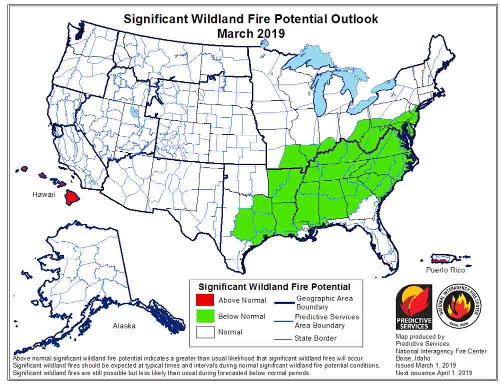
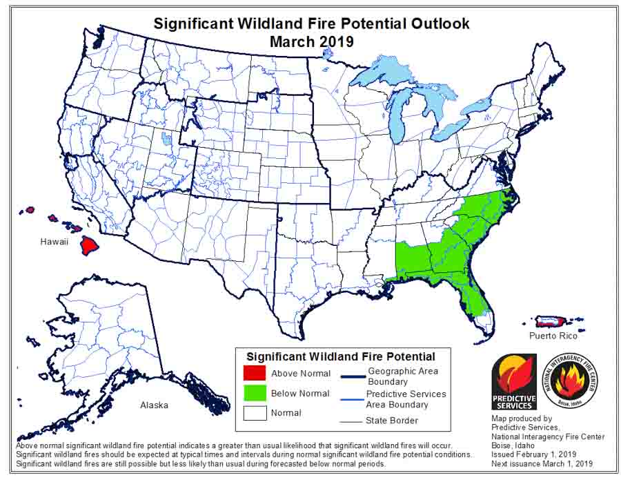
wildfire potential fire danger outlook forecastOn March 1 the Predictive Services section at the National Interagency Fire Center issued their Wildland Fire Potential Outlook for March through June. The data represents the cumulative forecasts of the ten Geographic Area Predictive Services Units and the National Predictive Services Unit.

If NIFC’s analysis is correct, in April wildfire activity should begin to increase in Eastern New Mexico and Western Texas. In May it will transition to the greater Grand Canyon area, with much of California added in June.

Below:

  • An excerpt from the NIFC narrative report for the next several months;
  • More of NIFC’s monthly graphical outlooks;
  • NOAA’s three-month temperature and precipitation forecasts; and,
  • Drought Monitor.

The majority of the nation remained out of fire season in February. The minimal fire activity observed continued to be well below average nation-wide. What was observed was minimal and limited mainly to the western fringes of the Southern Area. While a weak El Niño persisted, resulting weather conditions were atypical to what is often observed during such events. Precipitation was generally near to above average in most locations except for two regions. The central and southern Great Plains were especially dry, and the Deep South had pockets of dry conditions as well. Portions of West Texas and eastern New Mexico received less than 5% of average precipitation. Overall, the Deep South fared better but portions of the Carolinas and the lower Mississippi River Valley recorded below average precipitation.

Temperatures were generally within about 3 degrees of average across the country. A slight cold bias existed in the West and across the northern tier. A slight warm bias existed across the South and Texas. Extreme departures from average were observed across the northern Great Plains where temperatures were as much as 25 degrees below average.

The frequency and strength of Pacific weather systems moving on shore and across the West allowed for above average precipitation to reduce the severity and scope of the ongoing drought across California and portions of Oregon and the Great Basin. Incredible amounts of snowfall intermittently shut down travel across the High Sierra in California. Soil moisture levels improved across most areas except western Oregon where the persistent dry conditions continued.

March is a transition month. Pregreenup grassfire activity is not uncommon along and east of the Rocky Mountain Front. At least average activity is expected until green up takes hold. Concerns decrease west of the Continental Divide where sustained periods of wet and cold conditions have persisted the past few months. As greenup takes hold in April, most areas experiencing preseason activity should begin to see a decrease except for the Southwest where the drying of fuels begins to show a gradual westward migration of fire activity.

Fire activity in May and June should increase in coverage and intensity across the Southwest and California. Some slight expansion of activity into the southern Great Basin is also expected. The above average precipitation received during the late winter and early spring months could translate to another above average grass crop that could prove to be problematic in June.

wildfire potential fire danger outlook forecast

Continue reading “Wildfire potential, March through June”

Comparing the Haines Index with the Hot-Dry-Windy Index

In a comment on the earlier post about the Hot-Dry-Windy Index (HDW), Brian Potter, a research meteorologist with the U.S. Forest Service, offered to provide some preliminary results looking at how HDW performed during the 2017 Chetco Bar Fire in Oregon, as well as how the Haines index performed during that fire.

The HDW is a new tool developed for firefighters to predict weather conditions which can affect the spread of wildfires. It is described as being very simple and only considers the atmospheric factors of heat, moisture, and wind.

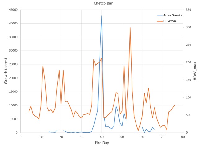
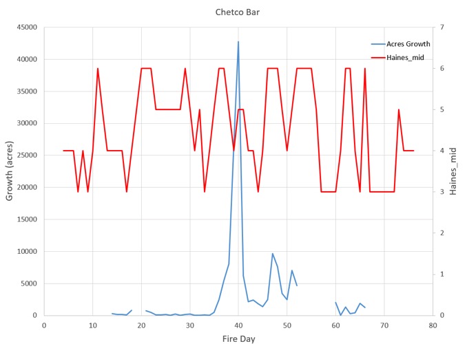
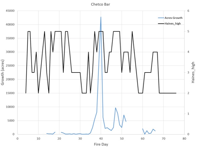
Mr. Potter has provided three figures showing the weather indices computed from the National Weather Service’s NAM model analyses. Because they use a different model from the HDW website, he does not have historic percentile values for HDW, but they are illustrative, nonetheless. These are preliminary data and have not been through peer review or evaluation.

Here is a graph of HDW values compared to growth on the Chetco Bar Fire:hot dry windy index fire growth

Here are the Haines Index values for the mid-elevation version of the Index:

Haines index fire growth

And the high elevation version of the Haines Index:

Haines index fire growth

Mr. Potter said he has some thoughts about the graphs, but is interested in hearing what others take away from them.

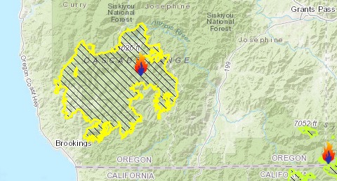
The Chetco Bar Fire in southwest Oregon started July 12, 2017 and burned over 191,000 acres.

Chetco Bar Fire map
Map showing the location of the Chetco Bar Fire (on the left) in southwest Oregon, October 2, 2017. USFS.

Wildfire potential, February through May

Wildfire potential in United States is expected be normal or below normal in most areas during the coming four months

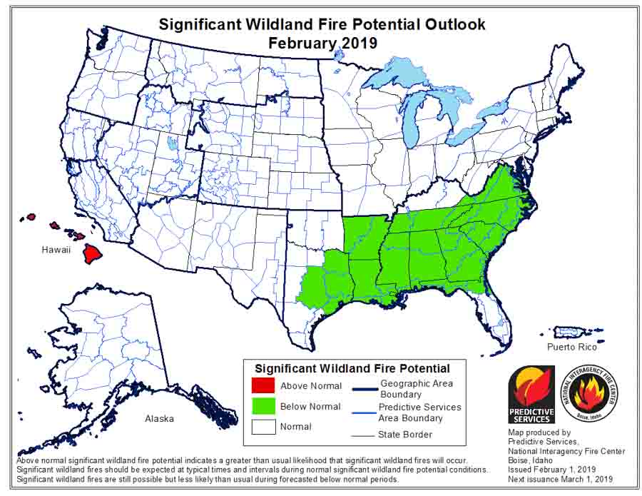
February wildfire potential outlook

After missing the January edition of the monthly fire potential outlook due to the shutdown of the Departments of Interior and Agriculture, today the Predictive Services section at the National Interagency Fire Center issued their Wildland Fire Potential Outlook for February through May. The data represents the cumulative forecasts of the ten Geographic Area Predictive Services Units and the National Predictive Services Unit.

If their analysis is correct, the wildfire potential for United States will be normal during the coming four months, except it will be below normal for most of the South and above normal for Hawaii.

The format of the written outlook has recently evolved. Verbiage about past weather and fuel conditions over the previous 30 to 60 days is more prominent along with descriptions for what is normal for the present and near future. Forecasts for what land managers will be faced with in the coming months are still in the document, and can be found in the sections for each geographic area.

Below:

  • An excerpt from the NIFC narrative report for the next several months;
  • More of NIFC’s monthly graphical outlooks;
  • NOAA’s three-month temperature and precipitation forecasts; and,
  • Drought Monitor.

Here is one section that discusses El Niño:

“Impacts from a fading El Niño event on late winter and spring weather conditions vary. They typically result in below average snowpack across the northwestern quarter of the nation and above average snowpack across the central portion of the West. The southern tier of the nation tends to experience wetter than average conditions, except possibly across West Texas which can be drier than average. The northern tier of the nation can be warmer than average which would promote a faster melting rate of the snowpack in the mountains across the Pacific Northwest and the Northern Rockies.”

March wildfire potential outlook

Continue reading “Wildfire potential, February through May”

Forecasters expect the West to be warmer and drier than average later in January

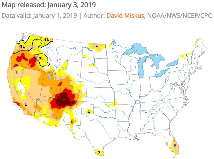
The east should be cooler, while the Drought Monitor shows Severe to Exceptional drought in the Four Corners area.

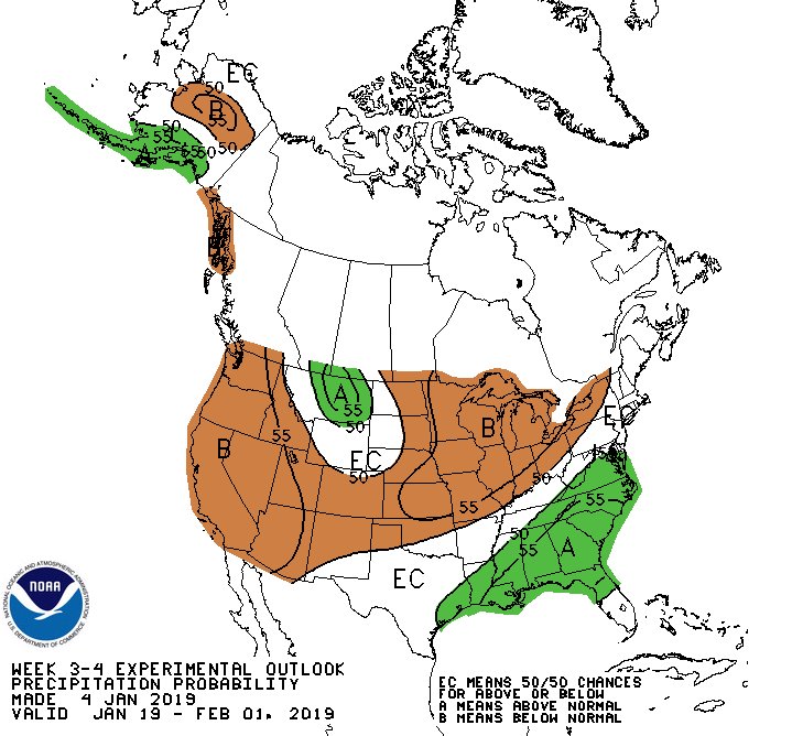
outlook for precipitation January
The outlook for precipitation in the second half of January.

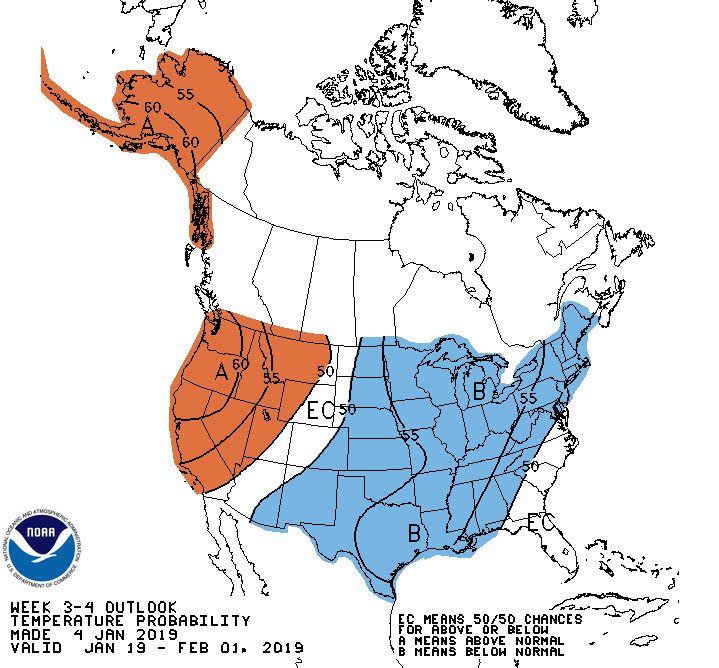
The three to four-week outlook issued January 4 for the second half of January predicts warmer and drier conditions in the Western United States. Areas east of the Rocky Mountains should be cooler. According to the National Weather Service Climate Prediction Center this is tied to tropical teleconnection responses and a building 500-hPa ridge forecast over northwestern North America.

Probably as a result of the partial shutdown of the federal government the Predictive Services section at the National Interagency Fire Center has not issued an updated Wildland Fire Potential Outlook at the beginning of the month as is customary.

outlook for temperature January
The outlook for temperature in the second half of January.

Below is the Drought Monitor released January 3, 2018.

Drought Monitor
The Drought Monitor shows Severe to Exceptional drought in the Four Corners area.

Drought Monitor legend

Wildfire potential, November through February

November wildfire outlook weather

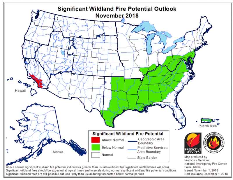
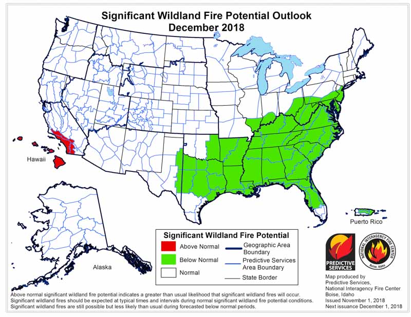
On November 1 the Predictive Services section at the National Interagency Fire Center issued their Wildland Fire Potential Outlook for November through February. The data represents the cumulative forecasts of the ten Geographic Area Predictive Services Units and the National Predictive Services Unit.

If their analysis is correct, the only areas with above normal wildfire activity during the period will be Southern California in November and December, and Hawaii December through February.

Below:

  • An excerpt from the NIFC narrative report for the next several months;
  • More of NIFC’s monthly graphical outlooks;
  • NOAA’s three-month temperature and precipitation forecasts; and,
  • Drought Monitor.

“Much of the West exited fire season by early October as the frequency of wet systems moving across the country increased. Cooler temperatures brought higher humidity levels and good overnight recoveries which also reduced large fire potential. As anticipated, the frequency of Santa Ana and North Wind events across California was lower than average, so critical fire weather periods were infrequent and of short duration. Nevertheless, fire activity was observed in isolated locations across the region in the remaining pockets where fuels remained critically dry. The Klondike fire made large runs mid-month. In the East, fire activity was also less active than average. This was due to the onset of a weak El Niño which promoted wetter than average conditions. The primary draw on resources was in response to Hurricane Michael which made landfall at Mexico Beach, Florida, with 155 mph winds.

“While most regions of the country are out of fire season during November, varying levels of activity are observed across California and the Southeast. The onset of El Niño should allow for a continuance of wetter than average conditions across the Southeast which should limit fire activity. However, pockets of critically dry fuels will persist across California, especially along coastal areas and along the front of the Southern Sierra. These areas will remain susceptible during wind events.

“Climatologically speaking, fire activity during the winter months, December through February, is at a minimum. Areas most susceptible to activity are generally restricted to the southeastern states where periodic increases in fire activity are possible during dry periods until spring greenup begins. However, current data and expected trends in precipitation suggest that large fire potential will be Below Normal in this region. The abundance of moisture should keep fuels in most areas from becoming critically dry. Drought forecasts project that the region should remain mostly free of drought.

“Across the West, overall warmer and drier than average conditions are expected. This should lead to below average snowpack in most mountain locations across the northern tier of the country. Snowpack should trend toward average levels moving south along the Continental Divide as the impacts of the El Niño begin to produce a positive effect on precipitation amounts received.”


December wildfire outlook weather
Continue reading “Wildfire potential, November through February”