The National Wildfire Coordinating Group has created a Wildland-Urban Interface Wildfire Mitigation Desk Reference Guide that is designed to provide basic background information on relevant programs and terminology for community members and agency personnel who are seeking to enhance their community’s wildfire mitigation efforts.
The four primary objectives of the reference guide are to:
Provide a reference to assist with integrating wildland-urban interface mitigation principles into national wildland fire training;
Promote common wildfire mitigation language and culture;
Establish an authoritative source for wildland-urban interface mitigation information; and
Provide consistent definitions for use by all media
Researchers have concluded that the most effective fire clearance or defensible space around structures, to reduce the chances of them burning in a wildfire, is between 16 and 58 feet.
Below is an excerpt from the abstract of a paper written by Alexandra D. Syphard, Teresa J. Brennan, and Jon E. Keeley, submitted to a journal September 16, 2014.
We analysed the role of defensible space by mapping and measuring a suite of variables on modern pre-fire aerial photography for 1000 destroyed and 1000 surviving structures for all fires where homes burned from 2001 to 2010 in San Diego County, CA, USA. Structures were more likely to survive a fire with defensible space immediately adjacent to them. The most effective treatment distance varied between 5 and 20 m (16–58 ft) from the structure, but distances larger than 30 m (100 ft) did not provide additional protection, even for structures located on steep slopes.
Two of the three authors are public employees, so the taxpayers already paid for this research. However, if you want a copy of The role of defensible space for residential structure protection during wildfires, it will cost you $25.
The other chart shows that while the often-heard statement that “humans cause most wildfires” is true, that is not the case in all areas. In the Great Basin lightning is the primary cause of fires, and there are almost as many lighting fires as human caused fires in the Northwest, Southwest, and Rocky Mountains.
A contractor uses an air curtain to burn and dispose of slash from a wildfire mitigation project near Custer, SD, May 22, 2013. Photo by Bill Gabbert.
The U.S. Forest Service announced yesterday:
****
NRCS and Forest Service Partner to Improve Forest Health
HELENA, Mont., February 6, 2014 – Agriculture Under Secretary for Natural Resources and Environment Robert Bonnie announced today a multi-year partnership between the U.S. Forest Service and the Natural Resources Conservation Service (NRCS) to improve the health and resiliency of forest ecosystems where public and private lands meet across the nation. The Under Secretary made the announcement in Helena, Mont., near the site of the Red Mountain Flume/Chessman Reservoir, one of the first areas to be addressed through the partnership. Another area to be targeted is the San Bernardino/Riverside County area of California which experienced catastrophic wildfires a decade ago.
“NRCS and the Forest Service have the same goal in this partnership – working across traditional boundaries and restoring the health of our forests and watersheds whether they’re on public or private lands,” Bonnie said.
Today’s announcement is part of the Obama Administration’s Climate Action Plan to responsibly cut carbon pollution, slow the effects of climate change and put America on track to a cleaner environment.
The project, called the Chiefs’ Joint Landscape Restoration Partnership, will invest $30 million in 13 projects across the country this year to help mitigate wildfire threats to communities and landowners, protect water quality, and supply and improve wildlife habitat for at-risk species.
The 13 priority projects will build on existing projects with local partnerships already in place. By leveraging technical and financial resources and coordinating activities on adjacent public and private lands, conservation work by NRCS and the Forest Service will be more efficient and effective in these watersheds.
“Wildfires and water concerns don’t stop at boundaries between public and private lands,” NRCS Chief Jason Weller said. “By working together, we can provide more focused and effective assistance to help public and private landowners and managers put conservation solutions on the ground nationwide.”
“The Chiefs’ Joint Landscape Restoration Partnership is an opportunity for our agencies to pool resources and get better results for the American people,” U.S. Forest Service Chief Tom Tidwell added. “Restoring the health of our nation’s forests and grasslands is a critical effort, and it’s going to take partnerships like this to see the job through.”
The 13 projects:
Montana – Red Mountain Flume/Chessman Reservoir: $865,000 for restoration of the watershed is critical to protecting communities, watershed health and drinking water, contributing 80 percent of the water supply for Helena, Mont. Successful implementation of this project will protect public health and safety, reduce the risk of decades of erosion and flooding that could result from a wildfire, and potentially save millions of dollars in mitigation costs.
California – San Bernardino and Riverside County Fuels Reduction Project: In October 2003, Southern California experienced catastrophic wildfires that burned over 750,000 acres, destroyed 3,500 homes, and resulted in 22 fatalities and over $3 billion in losses. Since then, multiple partners have committed time and resources to planning and implementing forest health and wildfire hazard reduction projects on private land and working with the owners within San Bernardino and Riverside Counties. Reducing forest fuels on 30,000 acres will provide additional protection for community safety, wildlife habitat, watershed health, recreation opportunities and cultural resources.
California – Mid-Klamath River Communities Project: The partnership has yielded numerous implementation-ready projects and treatments on some high priority federal and private lands are underway or complete. These treatments include fuel breaks, thinning, broadcast burning, and improved fire suppression infrastructure such as water tanks and ingress/egress routes. Although these projects are focused on communities, most of these projects have identified wildlife, water, and economic stability benefits.
The agencies are reviewing additional sites for the partnership to collaborate in the future and will continue to capitalize on NRCS and Forest Service overlying priorities and programs.
Last month a group of 20 wildfire experts met behind closed doors in Jackson, Wyoming to discuss methods for protecting communities from wildland fires. The meeting was closed to the public and reporters so that the participants could present ideas that are likely to be met with opposition in western areas where property rights at times trump attempts to impose regulations that would protect homes.
The “84 percent” of land in the Wildland Urban Interface (WUI) that is not yet developed received much of the attention at the forum. The attendees realized that efforts directed toward future construction could have a more profound effect than trying to make changes to existing structures.
The topics discussed included:
Fire risk mapping and mandatory notice.
Development plans that include standardized wildfire risk ratings.
Federal assistance based on fire-risk planning.
Denial of loans for houses in high-risk wildfire zones.
“There’s this invisible line you’re not allowed to cross,” said the forum’s organizer, Ray Rasker, director of Headwaters Economics, an independent research group focused on Western land management. “If you start talking about restricting private property rights, that’s sort of a career-ending conversation you’re having.”
[…]
Kathy Clay, Teton County, Wyo.’s outspoken fire marshal, acknowledges that she attended the forum, where she was popular for her discussion of “suicide subdivisions” – neighborhoods where firefighters have only one way in, no access to water or aerial support, and no way out if the fire spreads behind them. Clay wants the blunt phrase to draw attention to the rising human costs of wildfire.
“Firefighters have an obligation to defend structures, but we don’t have an obligation to put people in harm’s way,” Clay said in an interview.
Structure fire in Hot Springs, SD. Photo by Bill Gabbert.
The County Commissioners of Lewis and Clark County in Montana recently approved a resolution making it clear that county-level firefighters are not under an obligation to protect a home from a wildfire in the Wildland Urban Interface (WUI). Below is an excerpt from an article in the Missoulian:
“…A lot of crews think they have to protect homes, and we’re trying to make it clear they’re just sticks and bricks,” said Sonny Stiger, who helped write the resolution. “This lets our firefighters know they’re not obligated to put their lives on the line to save homes.”
Stiger, a retired fire and fuels specialist with the U.S. Forest Service and a board member with FireSafe Montana, said building defensible space around homes in the urban interface is the sole responsibility of property owners who choose to live there.
Stiger said the new resolution makes it clear that homeowners should not expect firefighters to put their lives at risk to defend property.
“We can save a lot of homes going back in after the fire front passes, or in the case of the Yarnell Hill fire, not going in at all,” Stiger said, referring to the Arizona blaze that killed 19 firefighters in June. “It’s time we stepped up at the county level to deal with this, and to let (firefighters) know they’re not obligated to protect homes…”
The resolution says in part:
Homes in the Wildland/Urban Interface will not dictate fire suppression tactics, strategies, or the location of fire lines.
The article claims this is a “first-of-its-kind resolution”, which may be the case. There is no doubt that some homeowners who moved into the WUI and refuse to cut or thin the trees and brush growing within 100 feet of their houses will be furious at this concept. Some of them take no responsibility as a property owner to make their homes fire-safe, but expect firefighters, many of them volunteers, to risk their lives to save their structures.
Placing the primary responsibility to protect a home from wildfire on the property owner, where it belongs, is very appropriate. County, city, and state regulations recognizing this do not exist in many areas..
On the Yarnell Hill Fire there was at least one person in a supervisory role who asked the Granite Mountain Hotshots to move from their safe, previously burned area, over to the the town of Yarnell in order to protect the structures, many of which were described later as not defendable due to brush and trees very close to the buildings. Some of the homeowners had done little or nothing to make their homes fire-safe. As the crew hiked through unburned brush toward the town, they were overrun by the fire and killed.
In the structural firefighting world you will sometimes hear opinions about risk-taking while fighting fire, including:
Risk a lot to save a lot.
Risk a little to save a little.
Risk nothing to save nothing.
“Risk a lot” usually refers to rescuing occupants or preventing their death. “Save nothing” may apply to an abandoned building.
In wildland fire, vegetation could be in the “nothing” category. Sure, wildland fuels may have ecological, watershed, aesthetic value, or monetary value in the case of timber or pasture, but most vegetation has adapted or evolved to burn on a regular basis and will usually grow back. Houses grow back too, but firefighters don’t. Firefighters should never risk much to save acres OR houses.
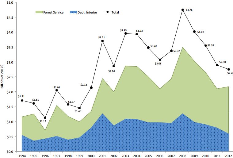
Headwaters Economics has released a report titled “The Rising Cost of Wildfire Protection”, written by Ross Gorte, Ph.D., a retired Senior Policy Analyst with the Congressional Research Service. It is an effort to better understand and address why wildfires are becoming more severe and expensive and it describes how the protection of homes in the Wildland-Urban Interface has added to these costs.
Below are some excerpts:
****
Figure 1. Federal Wildfire Appropriations to the Forest Service and Department of the Interior, 1994 – 2012. Source, Headwaters Economics (click to enlarge)
Fuel Reduction on Federal Lands
Programs to protect the WUI also affect fuel reduction on other federal lands. First, the Healthy Forests Restoration Act directed that half of federal fuel reduction funds were to be used in the WUI. As a result, the proportion of fuel treatments in the WUI increased after FY2001 (the first year for which such data are available), from 37 percent (45% for the FS, 22% for DOI) to about 60 percent from FY2003 to FY2006 (73% for the FS, 42% for DOI), and 70 percent in FY2008 (83% for the FS, 47% for DOI).
More recent comparable data are not available, because the FS has modified the way fuel treatments are reported and has proposed shifting non-WUI fuel treatment funding to land and resource management accounts (instead of wildfire protection accounts).
This shift in fuel treatments to the WUI has two effects on federal fuel reduction efforts:
It raises the average costs of reducing fuels on an acre of land. Treatments in the WUI are closer and more visible to humans and thus the public involvement process commonly takes longer and costs more. Mechanical treatments may require additional steps to reduce the visual impacts of removing biomass. Also, prescribed burning is, in many ways, the most effective means of reducing fuels, but the higher values and closer proximity of humans necessitate more personnel and more oversight to try to prevent the prescribed fires from becoming wildfires.23 One study found per-acre fuel reduction in the WUI costs 43 percent more for prescribed burning and nearly three times more for mechanical fuel reduction than in non-WUI areas.24
It results in less fuel reduction on other lands. The level of fuel reduction over the past decade has remained relatively stable—averaging about 3 million acres annually according to the agency budget justifications. Because efforts are increasingly being focused on the WUI, the level of fuel reduction on non-WUI lands is probably declining. Furthermore, as discussed in more detail in other reports, 25 the 3 million-acre effort is insufficient to treat the 230 million acres of federal lands at high or moderate risk of ecological damage from wildfires in a timely manner. Thus, wildfire fuel levels are currently increasing, and shifting more fuel reduction to the WUI will exacerbate the current situation. This is likely to lead to more severe wildfire seasons in the future.
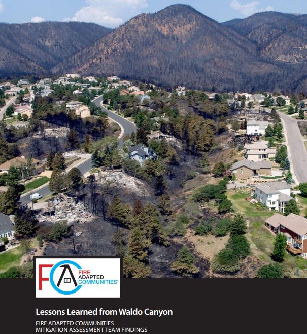
Lessons Learned from Waldo Canyon Fire, cover. Click to enlarge
The Fire Adapted Communities Coalition has prepared an excellent report titled “Lessons Learned from Waldo Canyon”. Written by representatives from the Insurance Institute for Business and Home Safety, U.S. Forest Service, International Association of Fire Chiefs, and the NFPA, it documents factors that affected the destruction or survival of structures during the Waldo Canyon Fire, a fire that destroyed 346 Colorado Springs homes in June of 2012. This document, along with the Texas report, “Common Denominators of Home Destruction”, could be very useful resources for communities and home owners that desire to mitigate potential damage before wildfires threaten their wildland-urban interface.
Often you will see media reports using words like “random” or “miracle” to describe how some homes are burned while others survive a wildfire that burns into a community. It is neither — it is science — and fuel reduction, building materials, screening off vents, plugging holes between roof tiles, a lack of combustible decks, the actions your neighbor takes or does not take, and many other factors. And did I mention fuel reduction?
While the city of Colorado Springs and their fire department has received criticism for their lack of operational preparedness and training for wildfires, as well as their actions during the Waldo Canyon Fire, this report indicates the city had a program that resulted in some positive outcomes related to fuel mitigation and home owner education about how to reduce the chances of structures burning during a wildfire event.
Here is a sample of some of the conclusions identified in the report:
Observations on building design and materials improvements and maintenance could have reduced losses:
Ember ignition via ignition of combustible materials on, in or near the home was confirmed by the surveys. This reaffirms the serious risk posed by ember ignitions to properties during wildfires. This reinforces the importance of maintaining an effective defensible space and regularly removing debris from areas on and near the home.
Home-to-home fire spread was again a major issue, as with prior post-fire field investigations. When it occurred, it was dependent on at least one wildland fire-to-home ignition and then home spacing and slope / terrain. Home-to-home fire spread was attributed to a relatively large number of home losses in this survey.
Wildland fire-to-home ignition was influenced by location of home on slope and fuels treatment(s) or lack of on the slope leading to the home.
A building can be hardened with noncombustible materials, for example, but it is also necessary to incorporate appropriate construction details, which will help ensure that the protections offered by those materials is not by-passed.
Individual homeowners must take responsibility for fortifying their property against wildfire damage by taking appropriate measures to incorporate noncombustible building materials and construction details.
Observations on the role of fuels management and landscape vegetation and features:
Past fuel treatments by mastication in heavy, continuous, mature Gambel oak retained multi-season effectiveness for reducing wildfire spread. Two- and three-year-old oak treatments did not carry fire. Oak leaves were scorched, but did not typically burn.
Hardened landscape barriers such as noncombustible retaining walls, paths and gravel borders were effective in stopping fire in lighter fuel types.
Pruning and thinning of ladder fuels in Gambel oak clumps, as a Firewise practice by homeowners, appeared to be effective in keeping fire on the ground and reducing crown fire potential.
Firewise landscape plants, primarily deciduous trees and shrubs, were scorched but did not burn when exposed to heat from adjacent crowning fuels.
Landscaping fencing contributed to fire spread from adjacent native areas to structures. Split rail and cedar privacy fencing both led fire to structures.
An article that appeared in the Missoulian and several other newspapers discusses research by Headwaters Economics about the costs of fighting wildfires in the wildland-urban interface. It includes some controversial quotes from a gentleman who is often sought by reporters when they need a quote about U.S. Forest Service fire management policies.
Below is an excerpt from the article. You will have to go to the Missoulian site to read the aforementioned quotes.
If Montana’s forest fringes continue filling with houses, wildland firefighting costs could double, according to a report by the Bozeman-based Headwaters Economics.
“Protecting homes is a major cost and safety issue in fighting fire,” said Headwaters author Chris Mehl. “But the real question is personal responsibility: Who pays for that? Right now, the federal government – the Forest Service, BLM or FEMA – pays for a disproportionate share of the cost of fighting fires and cleaning up afterward. States and municipalities pay a small share of the cost.
“The challenge is, if we keep building these homes in the wildland-urban interface, who should bear the cost? Will localities say we’re not willing to bear the cost and you landowners must bear more? We need to look at land-use planning.”

 The National Wildfire Coordinating Group has created a Wildland-Urban Interface Wildfire Mitigation Desk Reference Guide that is designed to provide basic background information on relevant programs and terminology for community members and agency personnel who are seeking to enhance their community’s wildfire mitigation efforts.