This article was first published at Fire Aviation September 24, 2020
The Australian Transport Safety Bureau (ATSB) has released an interim report about the January 23, 2020 crash of a C-130, Air Tanker 134, that killed the three crewmembers on board. This follows the preliminary report the agency issued in February, 2020. The aircraft was known as Bomber 134 (B134) in Australia.
“The interim report does not contain findings nor identify safety issues, which will be contained in the final report. However, it does detail the extensive evidence gathered to date, which has helped ATSB investigators develop a detailed picture of this tragic accident’s sequence of events,” said ATSB Chief Commissioner Greg Hood.
Tanker 134 (B134) at Medford, Oregon July 27, 2019. Photo by Tim Crippin.
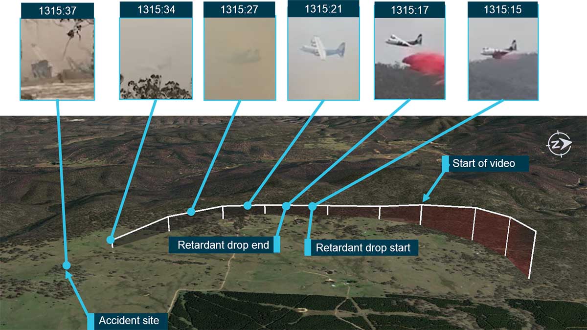
It was very windy on January 23, with a forecast for the possibility of mountain waves. Before the incident a birddog, similar to a lead plane, and Bomber 137 (B137), formerly Tanker 138, a Boeing 737 that Coulson sold to New South Wales, was tasked to drop on a fire in the Adaminaby area. Based on the weather the birddog pilot declined the assignment. After B137 made a drop on the fire, the crew reported having experienced uncommanded aircraft rolls up to 45° angle of bank (due to wind) and a windshear warning from the aircraft on‑board systems.
After completing the drop, the B137 crew sent a text message to the birddog pilot indicating that the conditions were “horrible down there. Don’t send anybody and we’re not going back.” They also reported to the Cooma FCC that the conditions were unsuitable for firebombing operations. During B137’s return flight to Richmond, the Richmond air base manager requested that they reload the aircraft in Canberra and return to Adaminaby. The Pilot in Command (PIC) replied that they would not be returning to Adaminaby due to the weather conditions.
B134 was dispatched to the fire at Adaminaby. While they were in route, the PIC of B137 called to inform them of the actual conditions, and that B137 would not be returning to Adaminaby.
After arriving at Adaminaby the PIC of B134 contacted the air operations officer at the Cooma FCC by radio and advised them that it was too smoky and windy to complete a retardant drop at that location. The Cooma air operations officer then provided the crew with the location of the Good Good Fire, about 58 km to the east of Adaminaby, with the objective of conducting structure and property protection near Peak View. Again, there was no birddog operating with the air tanker.
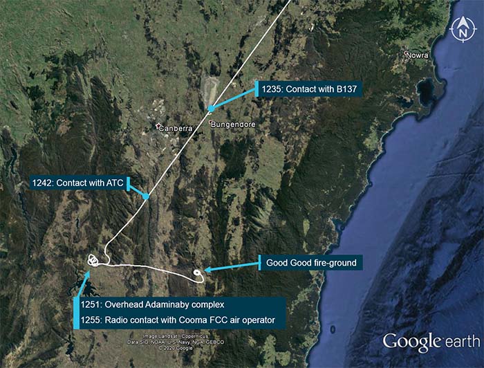
Flight path overview (in white), including the times and locations of where the crew of B134 was in communication with others. From the report.
Northeast of Fresno, California earlier this month
Satellite photo showing smoke from fires in California at 6:01 p.m. PDT Sept 5, 2020. NASA/Wildfire Today. The Creek Fire
The Creek Fire ran for more than 10 miles and burned 36,000 acres during the first 22 hours after it started at 6 p.m. September 4 northeast of Fresno, California. During that time it created two fire tornados and sent its smoke plume up to 55,000 feet, taller than the tornadic thunderstorms in tornado alley.
An analysis by meteorologists from the National Weather service has revealed that the extreme growth on September 5 generated rare phenomenons — vortices rated at EF2 and EF1, sometimes called fire tornados when they are created by a wildfire.
One was near Mammoth Pool Reservoir and the other was near Huntington Lake. Over 200 people trapped by the fire at Mammoth Pool Reservoir were flown out by courageous National Guard Pilots in helicopters, at times through darkness and smoke.
The NWS personnel rated the vortices based on the effects on trees, including areas where trees were debarked, indicating an EF2 event.
Below is an excerpt from an article by Matthew Cappucci in the Washington Post.
Jerald Meadows, the warning coordination meteorologist at the Hanford office, said both tornadoes shared common features. “The main contributing factor was the debarking of all the pine trees up with the Mammoth Pool tornado,” Meadows said. “They both uprooted trees to the root balls and snapped large pines. But the [EF1 tornado] did not have any signs of true debarking. We’re probably talking the difference between 100 and 110 miles per hour.”
The Mammoth Pool tornado, which touched down inside the Wagner Campground, snapped several two-foot-diameter trees about 20 to 30 feet above the ground; it was rated as having winds of 115 to 125 mph. The Huntington Lake fire tornado had winds of 90 to 107 mph, and the NWS noted that it was “the result of unprecedented fire activity.”
The article reports that the NWS personnel on duty while the tornados were occurring had concerns about activating their severe weather warning system.
“A tornado warning was considered but not issued,” said [Jerald Meadows, the warning coordination meteorologist at the Hanford Office], who feared that disseminating such an alert might leave people unnecessarily conflicted about deciding whether to shelter or evacuate.
“A tornado warning for a fire opens up a can of worms,” he said. “We want to make sure we’re messaging properly, and we were talking to fire crews letting them know of the circulations we were seeing.”
Before the onslaught of fire tornadoes that has been a hallmark of 2020′s blazes, some National Weather Service offices have had internal discussions and concluded that they would not issue tornado warnings for wildfire-related twisters. While the National Weather Service hasn’t issued specific policy guidance to its 122 forecast offices on how to handle fire tornadoes, Meadows suspects considerable research will be needed to reach a resolution.
This article was edited September 26 to clarify the locations of the fire tornados at Mammoth Pool Reservoir and Huntington Lake.
Authorities in Southern California are searching for Carlos Alexander Baltazar, a member of the Big Bear Interagency Hotshot crew. The San Bernardino County Sheriff’s office said he was reported missing by his family September 24. His car was found abandoned on Highway 18 near Delta Avenue by the California Highway Patrol on September 20, about 75 yards from his backpack.
The Sheriff’s office said Mr. Baltazar was was off duty when he abandoned his vehicle and was not in the area of the El Dorado Fire.
Anyone with information about Mr. Baltazar’s location should contact San Bernardino County Sheriff Dispatch at 760-956-5001.
Another member of the Big Bear Hotshots, Charlie Morton, became missing September 17, 2020 while working on the El Dorado Fire in San Bernardino County and was found deceased the next day. No cause of death has been released. A memorial service was held for Mr. Morton Friday morning, September 25.
It would appropriate $300M annually for the federal land management agencies’ prescribed fire programs. But are there other ways to reduce fire risk?
September 24, 2020 | 8:10 a.m. MDT
Prescribed fire at Chickasaw National Recreation Area in Oklahoma by M. Fidler, February, 2013.
A bill has been introduced in the U.S. Senate that would make large sums of money available to increase the number of acres treated with prescribed fire (also known as controlled burns).
It has been fashionable during the last two years to blame “forest management” for the large, devastating wildfires that have burned thousands of homes in California. According to a 2015 report by the Congressional Research Service the federal government manages 46 percent of the land in California. The California Department of Forestry and Fire Protection manages or has fire protection responsibility for about 30 percent.
Research conducted in 2019 to identify barriers to conducting prescribed fires found that in the 11 western states the primary reasons cited were lack of adequate capacity and funding, along with a need for greater leadership direction and incentives. Barriers related to policy requirements tended to be significant only in specific locations or situations, such as smoke regulations in the Pacific Northwest or protecting specific threatened and endangered species.
The National Prescribed Fire Act of 2020, Senate Bill 4625, which was introduced last week by Senator Ron Wyden of Oregon and two cosponsors, would help address the capacity issue by appropriating $300 million for both the Forest Service and the Department of the Interior (DOI) to plan, prepare, and conduct controlled burns on federal, state, and private lands. It would also provide $10 million for controlled burns on county, state and private land that are at high risk of burning in a wildfire. Additionally, the bill establishes an incentive program that would provide $100,000 to a State, county, and Federal agency for any controlled burns larger than 50,000 acres. (Summary and text of the bill)
In order to carry out the projects, the legislation would establish a workforce development program at the Forest Service and Department of the Interior to develop, train, and hire prescribed fire practitioners, and creates employment programs for Tribes, veterans, women, and those formerly incarcerated.
In an effort to address air quality control barriers, the bill “Requires state air quality agencies to use current laws and regulations to allow larger controlled burns, and give states more flexibility in winter months to conduct controlled burns that reduce catastrophic smoke events in the summer.” The legislation will allow some prescribed fire projects larger than 1,000 acres to be exempt from air quality regulations.
Our Take
Appropriating more funds and hiring additional personnel for conducting prescribed fires could definitely result in more acres treated. If the bill passes, it would be a large step in the right direction. It is notable that the bill specifically mentions hiring those who were formerly incarcerated. Those who served time for non-violent offenses often deserve another chance, especially if they learned the firefighting trade on a state or county inmate fire crew.
There are many benefits of prescribed fires, including more control over the adverse health effects of smoke, improving forest health, and returning fire to dependent ecosystems.
But it gets complicated when prescribed fire is expected to “…help prevent the blistering and destructive infernos destroying homes, businesses and livelihoods”, as cited in a release issued last week by the Senate Committee on Energy and Natural Resources.
One provision of the bill is poorly worded and is confusing. In Section 102 it is either saying that no later than September 30, 2022 every unit of the USFS, FWS, NPS, and BIA must conduct a prescribed fire larger than 100 acres, possibly only applying to units west of the 100th meridian. Or, it might be interpreted as meaning each unit larger than 100 acres must conduct at least one prescribed fire. But either way it is ridiculous and arbitrary. Some 100-acre units might never be suitable for prescribed fire. Planning to use fire as a tool is based on science and the determination that treating an area with fire is PRESCRIBED in order to accomplish a number of specific objectives, not well-meaning but possibly detrimental legislation.
Scenario #1, Moderate fire conditions
There is no doubt that if a wildfire is spreading under moderate conditions of fuels and weather (especially wind), when the blaze moves into an area previously visited by any kind of fire the rate of spread, intensity, and resistance to control will decrease. Firefighters will have a better chance of stopping it at that location. The size of that earlier fire footprint will be a factor in the effectiveness of stopping the entire fire, since the wildfire may burn through, around, or over it by spotting. The availability of firefighting resources to quickly take advantage of what may be a temporary reduction in intensity is also critical. Unless the prescribed fire occurred within the last year or so there is usually adequate fuel to carry a fire (such as grass, leaves, or dead and down woody fuel) depending on the vegetation type and time of year. It is much like using fire retardant dropped by air tankers. Under ideal conditions, the viscous liquid will slow the spread long enough for firefighters on the ground to move in and put out the fire in that area. If those resources are not available, the blaze may eventually burn through or around the retardant.
Scenario #2, Extreme fire conditions
The wildfires that burn hundreds or thousands of homes usually occur during extreme conditions. What the most disastrous fires have in common is drought, low fuel moisture, low relative humidity, and most importantly, strong wind. In the last few weeks in California and Oregon we have seen blazes under those conditions spread for dozens of miles in 24 hours.
Rich McCrea, the Fire Behavior Analyst on the recent North Complex near Quincy, CA, said the wind on September 8 pushed the fire right through areas in forests that had been clear cut, running 30 miles in about 18 hours.
We can’t log our way out of the fire problem.
Burning embers lofted by the Creek Fire are seen as people are sheltering at the Mammoth Pool Reservoir Boat Launch, Sept. 5, 2020 in Northern California. Photo by Cameron Colombero, via Mike Ikahihifo.
On September 8, 2020 the Almeda Drive Fire burned 3,200 acres in Southern Oregon — it was not a huge fire, but there were huge losses. The 40 to 45 mph wind aligned with the Interstate 5 corridor as it burned like a blowtorch for 8 miles, starting north of Ashland and tearing through the cities of Talent and Phoenix. Approximately 2,357 structures were destroyed — but not all by a massive flaming front. Burning embers carried up to thousands of feet by the fire landed in receptive fuels near or on some structures, setting them alight.
A portion of the Almeda Drive Fire in the area of Phoenix and Talent in southern Oregon. Screenshot from video shot by Jackson County on September 8, 2020.
What can be done to reduce fire losses?
Jack Cohen is a retired U.S. Forest Service Research fire scientist who has spent years determining how structures ignite during extreme wildfires. In a September 21, 2020 article he wrote for Wildfire Today with Dave Strohmaier, they addressed how homes ignite during extreme wildfires.
“Surprisingly, research has shown that home ignitions during extreme wildfires result from conditions local to a home. A home’s ignition vulnerabilities in relation to nearby burning materials within 100 feet principally determine home ignitions. This area of a home and its immediate surroundings is called the home ignition zone (HIZ). Typically, lofted burning embers initiate ignitions within the HIZ – to homes directly and nearby flammables leading to homes. Although an intense wildfire can loft firebrands more than one-half mile to start fires, the minuscule local conditions where the burning embers land and accumulate determine ignitions. Importantly, most home destruction during extreme wildfires occurs hours after the wildfire has ceased intense burning near the community; the residential fuels – homes, other structures, and vegetation – continue fire spread within the community.
“Uncontrollable extreme wildfires are inevitable, however, by reducing home ignition potential within the HIZ we can create ignition resistant homes and communities. Thus, community wildfire risk should be defined as a home ignition problem, not a wildfire control problem.”
"Community wildfire risk should be defined as a home ignition problem, not a wildfire control problem." Jack Cohen and Dave Strohmaier.
Again, prescribed fire has many benefits to forests and ecosystems, and Congress would be doing the right thing to substantially increase its funding.
But in order to “…help prevent the blistering and destructive infernos destroying homes, businesses and livelihoods”, we need to think outside the box — look at where the actual problem presents itself. The HIZ.
I asked Mr. Cohen for his reaction to the proposed legislation that he and I were not aware of when the September 21 article was published.
“Ignition resistant homes, and collectively communities, can be readily created by eliminating and reducing ignition vulnerabilities within the HIZ,” Mr. Cohen wrote in an email. “This enables the prevention of wildland-urban fire disasters without necessarily controlling extreme wildfires. Ironically, ignition resistant homes and communities can facilitate appropriate ecological fire management using prescribed burning. The potential destruction of homes from escaped prescribed burns is arguably a principal obstacle for restoring fire as an appropriate ecological factor. Therefore, it is unlikely that ecologically significant prescribed burning at landscape scales will occur without ignition resistant homes and communities.”
Here are some suggestions that could be considered for funding along with an enhanced prescribed fire program.
Provide grants to homeowners that are in areas with high risk from wildland fires. Pay a portion of the costs of improvements or retrofits to structures and the nearby vegetation to make the property more fire resistant. This could include the cost of removing some of the trees in order to have the crowns at least 18 feet apart if they are within 30 feet of the structures — many homeowners can’t afford the cost of complete tree removal.
Cities and counties could establish systems and procedures for property owners to easily dispose of the vegetation and debris they remove.
Hire crews that can physically help property owners reduce the fuels near their homes when it would be difficult for them to do it themselves.
Provide grants to cities and counties to improve evacuation capability and planning, to create community safety zones for sheltering as a fire approaches, and to build or improve emergency water supplies to be used by firefighters.
Archie Creek Fire map, 2:35 p.m. PDT Sept. 22, 2020.
A heavy equipment operator passed away on the Archie Creek Fire in Western Oregon. The Incident Management Team announced September 23 the death of Walter (Wally) Samuel Elsbury, Jr., who was found unresponsive in his vehicle at a staging area September 18, 2020 before he began his shift.
The Douglas County Sheriff’s Office responded and notified Mr. Elsbury’s family. No foul play is suspected.
Mr. Elsbury, of Elsbury Logging Company in Burns/Hines, Oregon, had been working on the fire for about a week as skidgeon operator. He was helping to protect structures along Little River Road south of Glide on the west flank of the fire.
“The Bureau of Land Management, Umpqua National Forest, and Douglas Forest Protective Association are deeply saddened over Mr. Elsbury’s death,” said Incident Commander Mike Dueitt. “We want the Elsbury family to know our Incident Management Team, the firefighting community as a whole, and the residents along Little River Road are forever grateful for the work Wally did to protect homes from the Archie Creek Fire. Our condolences to you for the loss of your loved one.”
The fire has burned 131,000 acres since it started on September 8.