Civilian use of drone delays firefighting efforts in North Idaho

single engine air tanker drops on the Moyie Fire
A single engine air tanker drops on the Moyie Fire August 21, 2022 near Moyie Springs, Idaho. Photo by Idaho Department of Lands.

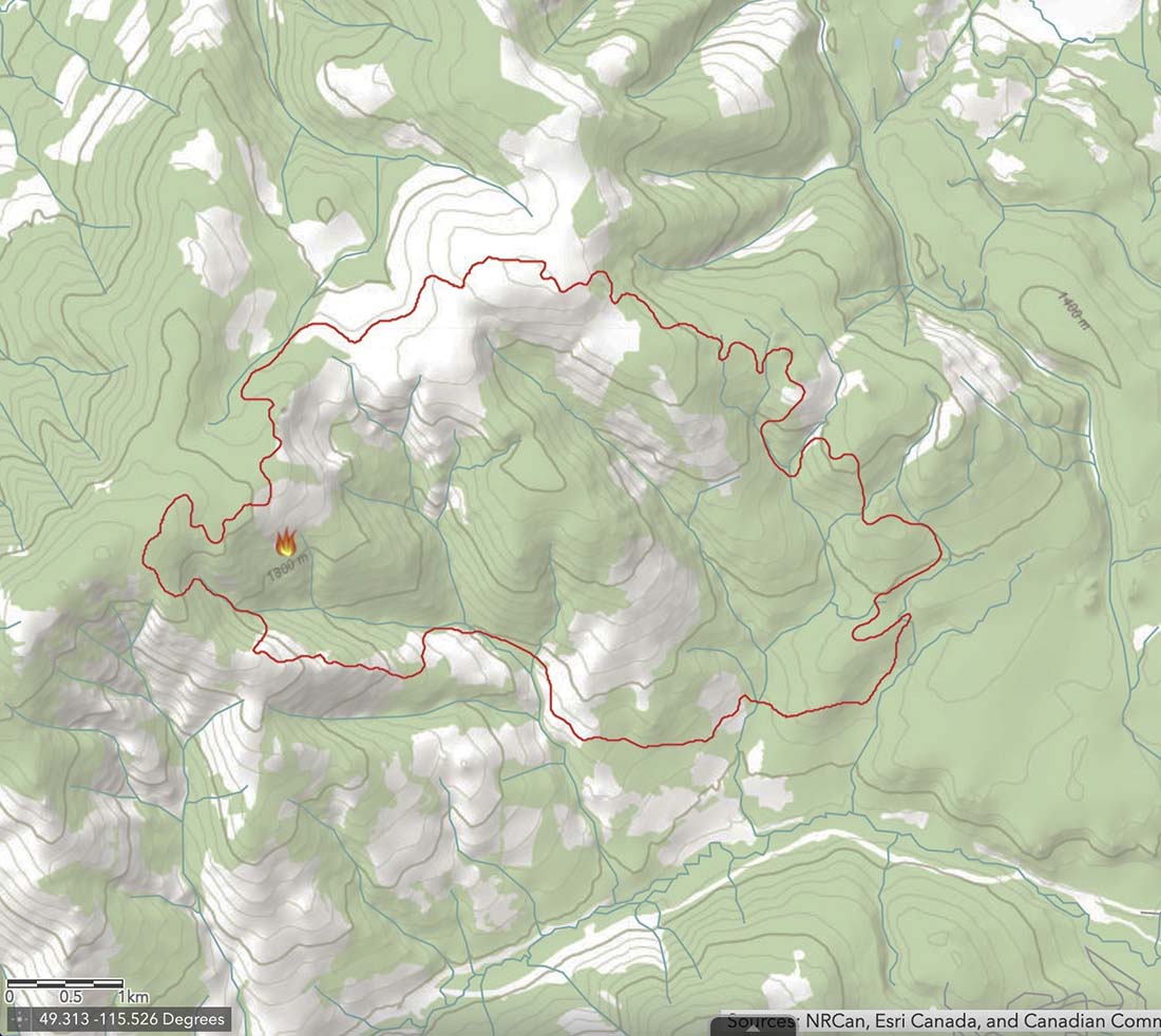
Firefighters on the ground battling the Moyie Fire had to wait on aircraft support because a civilian drone was being flown in the area August 21 near Moyie Springs.

Aircraft ordered for the fire could not immediately fly because of the drone.

“The residents of approximately 50 homes in Moyie Springs were notified of the fire and the potential need for evacuation,” said Josh Harvey, Idaho Department of Lands  Fire Bureau Chief. “Clearly, we needed to get air support for the firefighting effort as soon as possible and the drone put that on hold. Unfortunately this type of situation is not uncommon. We are reminding the public that drones can put firefighters, homes, and resources at risk.”

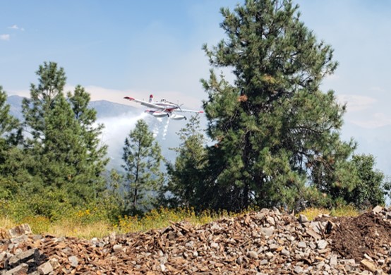
After the drone was gone, multiple firefighting aircraft went to work attacking the fire repeatedly while ground crews constructed a fire control line using hand tools. The fire was kept to three acres.

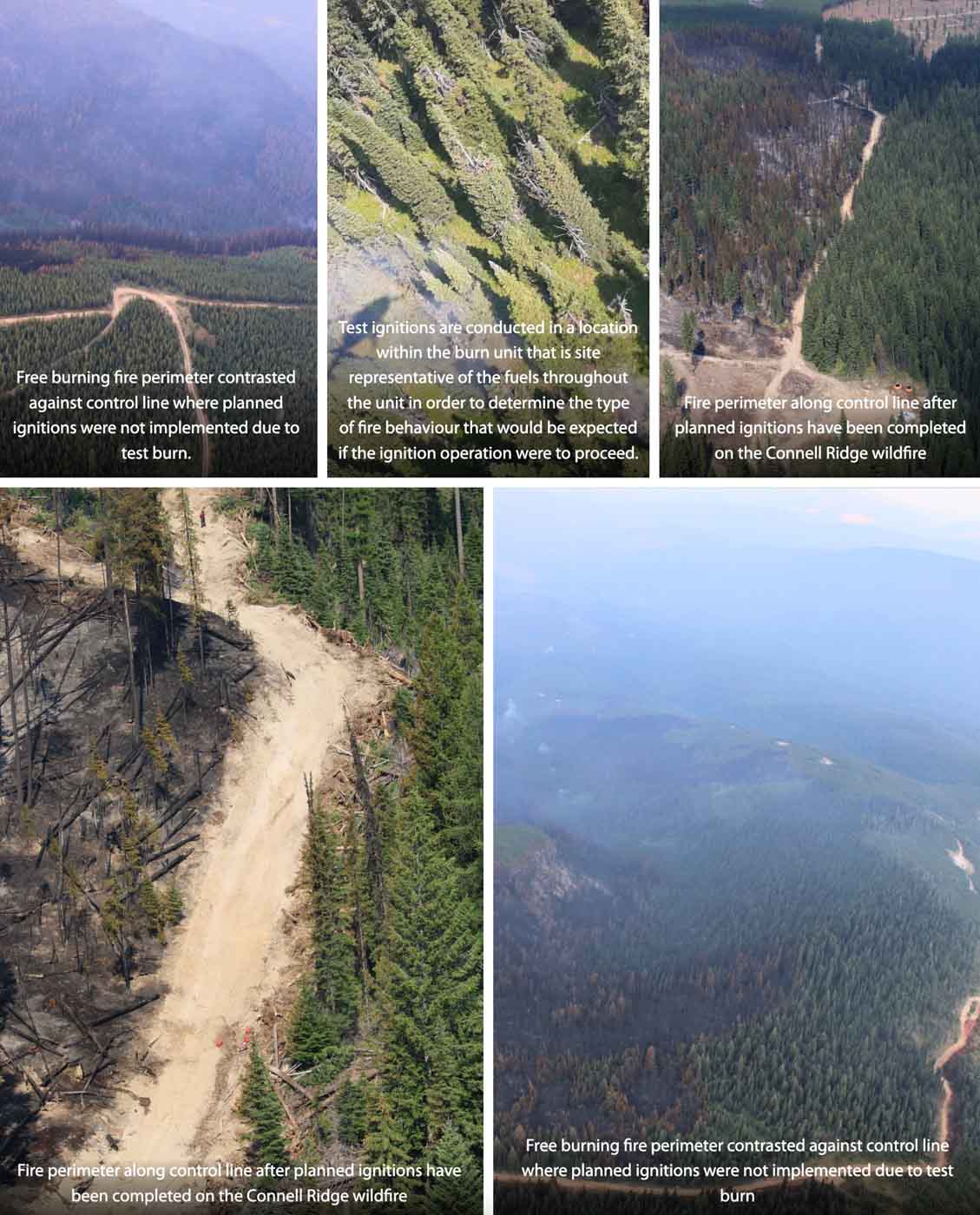
It is very dangerous to fly a civilian drone near a fire at which helicopters or fixed wing aircraft are operating. A collision could impact the windscreen or damage the engine, props, rotors, or flight control surfaces, causing a crash. If a drone is seen near a fire the standard operating procedure is to remove all aircraft from the fire area until it is confirmed that the drone has left the scene. In other words, it interferes with firefighting efforts.

It’s a federal crime punishable by up to 12 months in prison to interfere with firefighting efforts on public lands. Additionally, Congress has authorized the FAA to impose a civil penalty of up to $20,000 against any drone pilot who interferes with wildfire suppression, law enforcement, or emergency response operations. The FAA treats these violations seriously, and will immediately consider swift enforcement action for these offenses.

Arrest made in theft of wildfire detection equipment in Oregon

thief battery solar panel Oregon fire lookout camera
Person suspected of stealing solar panel and battery from Oregon DOF fire camera system August 14, 2022. Image from surveillance footage.

An anonymous tip led to the arrest of a thief who broke into an Oregon Department of Forestry (ODF) lookout tower in the Prospect area last week [and stole batteries and solar panels used to power the lookout tower’s fire detection camera]. The suspect, Chad Allen McPherson, 30, of Prospect, was indicted today, August 23, by a Grand Jury and charged with second-degree burglary, first-degree theft, first-degree criminal mischief, possession of burglary tools, and felon in possession of a restricted weapon. McPherson is lodged in the Jackson County Jail and due to a parole violation for felon in possession of a firearm is not eligible for pre-trial release.

McPherson and another suspect were captured on surveillance footage breaking into the tower around 12:45 on Sunday, August 14. The additional suspect shown in the surveillance footage has not been identified. Jackson County Sheriff’s Office (JCSO) detectives have identified a person of interest and are actively working to identify the additional suspect by analyzing latent prints and submitting DNA.

JCSO detectives arrested McPherson during a traffic stop Friday after receiving the tip and matching his photos to the surveillance footage. After searching his vehicle, detectives discovered burglary tools. During a search warrant of his property on the 2000 block of Shelly Lane in Prospect, detectives found a restricted weapon he was prohibited from possessing as a convicted felon. Investigators also discovered a black-market marijuana grow on the property. Illegal Marijuana Enforcement Team (IMET) detectives served a search warrant and destroyed 256 cannabis plants and 300 lbs. of processed black-market marijuana on the property. There was no licensing for any type of cannabis growing, handling, or processing at this location.

Later Friday, Dispatch received a call about a duffel bag at the intersection of 1st Street and Highway 62 with a note which read “call the cops.” JCSO deputies retrieved the bag and it contained items matching that of the stolen ODF equipment. The solar panels and batteries are still missing. The theft disabled ODF’s early fire detection capability for the northeastern portion of Jackson County near Prospect. ODF is currently working to get the camera system back up and running.

This case is ongoing with detectives working additional leads. If you have any information on the additional suspect or the whereabouts of the missing equipment, call the JCSO Tip Line at (541) 774-8333 and reference case 22-4725.

From the Jackson County Sheriff’s Office in Oregon.


After the arrest the Oregon Department of Forestry said, “Some of the equipment has been retrieved, however we’re still moving forward in ordering the parts and pieces we need to get our camera back up and running; early fire detection is one of our top priorities.”

Thanks and a tip of the hat go out to Tom.

President signs legislation to recognize suicide as a line-of-duty death for first responders

Firefighter on the Cerro Paledo Fire
Firefighter on the Cerro Paledo Fire in New Mexico, May, 2022 by Blake McHugh.

Last week President Biden signed H.R. 6943, the Public Safety Officer Support Act, into law. The legislation expands death and disability benefits under the Public Safety Officers’ Benefits (PSOB) program to include first responders who die by suicide or are disabled by traumatic experiences.

The new law will:

  • Allow public safety officers to seek disability benefits for PTSD linked to severe trauma by directing the PSOB to designate work-related PTSD and acute stress disorders as a line of duty injury for eligible officers as well as those who are permanently disabled as a result of attempted suicide; and
  • Allow families of public safety officers who die by trauma-linked suicide to apply for death benefits by directing the PSOB to presume that suicides are a result of job duties in certain traumatic circumstances where there is evidence that PTSD or acute stress disorder would be the cause of the injury.

The bill states that first responders or their survivors may qualify for benefits if their suicide or post-traumatic stress disorder was related to being exposed to “a harrowing circumstance posing an extraordinary and significant danger or threat to the life of or of serious bodily harm to any individual.” There are other requirements and details which are in the copy of the five-page bill below:

[pdf-embedder url=”https://wildfiretoday.com/wp-content/uploads/2022/08/H.R.6943.pdf” title=”H.R. 6943″]

Firefighters attacking the Valley Fire north of Pine Valley, California

UPDATED at 2:27 p.m. PDT August 23, 2022

Firefighters have stopped the spread of the Valley Fire north of Pine Valley, California. It was not active overnight and is being held at 188 acres. Pine Creek Road is still closed and there never were any evacuations.

On Tuesday crews are working on constructing fire line along the perimeter.

The cause is under investigation.


Updated at 5:45 p.m. PDT August 22 2022

The cameras are showing very little smoke at the Valley Fire north of Pine Valley, CA. The latest size estimate is 127 acres. All air tankers have returned to their bases but a couple of helicopters and Air Attack are still on scene.

There is very little radio traffic, which reminds me of the old saying, “When the radio traffic stops, the fire goes out.”


UPDATED at 3:21 p.m. PDT August 22, 2022

Valley Fire map, 1:33 p.m. PDT Aug. 22, 2022
Valley Fire map, 1:33 p.m. PDT Aug. 22, 2022.

The Valley Fire north of Pine Valley, California was mapped by an aircraft at 1:33 p.m. August 22 at 120 acres. About an hour later the size was estimated at 175 to 200 acres.

It is burning on both sides of Pine Creek Road at the intersection of Deer Park Road near Noble Canyon two air miles north of Old Highway 80.


UPDATE at 2:53 p.m. PDT August 22, 2022

At 2:29 p.m. the Incident Commander on the Valley Fire reported that it had grown to 175 to 200 acres, with a moderate to rapid rate of spread.

Valley Fire
Valley Fire looking NNE from Los Pinos at 2:43 p.m.
Valley Fire
Valley Fire north of Pine Valley, CA, August 22, 2022. CAL FIRE photo.

No evacuations are in effect and it is spreading away from structures in the Pine Valley area.


UPDATE at 1:10 p.m. PDT August 22, 2022

Valley Fire, 1:10 p.m. PDT Aug. 22, 2022
Valley Fire, 1:10 p.m. PDT Aug. 22, 2022. ABC10.

Firefighters from the Cleveland National Forest and CAL FIRE are attacking the Valley Fire which was reported Monday at about 11:37 a.m. a few miles north of Pine Valley, California near Pine Creek Road and Noble Canyon.

At 1:36 p.m. the size was estimated at 120 acres with a moderate rate of spread.

Aircraft over the Valley Fire at 1:27 p.m. PDT Aug. 22, 2022.

In addition to numerous engines, aircraft dispatched include several helicopters plus approximately nine air tankers, one of which is a DC-10.

Valley Fire
Valley Fire looking NNE from Los Pinos at 1:19 p.m.

At 2:02 p.m. the weather at Cuyamaca Peak northwest of the fire was wind out of the west at 12 mph, 70 degrees, with 44 percent relative humidity. The fire is in the large valley that runs north from the community of Pine Valley, so until the fire spreads up onto higher slopes it may be partially sheltered from the 12 mph wind measured at the top of Cuyamaca Peak. Brush fires rarely spread rapidly when the humidity is above 40 percent, but the fuel moisture, depending on what it is during this drought, may also be a major factor.

The Valley Fire is about 36 air miles east of San Diego, north of Interstate 8.

Making a decision about a proposed planned ignition on a wildfire

How it was done on the Connell Ridge Fire in British Columbia

Evaluating a possible planned ignition on the Connell Ridge Fire in British Columbia
Evaluating a possible planned ignition on the Connell Ridge Fire in British Columbia. Photo: BC Wildfire Service.

The British Columbia Wildfire Service (BCWS) has been working to contain the 4,230-acre Connell Ridge Fire 14 miles south of Cranbrook since it was reported August 1. It was likely started by lightning.

Crews had already completed burnouts (or planned ignitions) on the south flank and southeast corner but on August 19 a decision had to be made about whether to conduct an additional burnout on the southwest side. After a test burn, the Incident Management Team decided not to conduct the burnout.

Map of the Connell Ridge Fire, Aug. 21,1 2022
Map of the Connell Ridge Fire, Aug. 21,1 2022. BCWS.

The BCWS created the explanatory article and illustrations, below, about some of the considerations and steps taken as the decision was being made. It is rather extraordinary for a land management agency, at least in the United States, to provide this degree of transparency and detail about how a suppression decision was made. This could serve as an example for others to follow, especially when “big box” strategies are used that result in burning thousands of acres of green vegetation, too often with insufficient thought about ignition tactics, second order results, air quality, and long term fire effects.

The article below uses the term “guard” in the first paragraph which I believe in this context refers to a completed control line intended to stop the spread of the fire.

Information Officers on Type 1 Incident Management Teams should be capable of creating valuable content like this:


August 21, 2022

Test ignitions were conducted on the morning of August 19, 2022 on the Connell Ridge (N10989) wildfire, in anticipation of implementing planned ignition operations on the southwest corner. These test ignitions allow our crews and operational staff to determine if the unburnt fuels between the fire perimeter and the guard will be receptive to burning.

The area that the small-scale ignition was planned for is in steep terrain where the fire has been naturally burning in a patchy manner as the fire finds drier fuels that are able to ignite. This means there is a lot of unburnt, greener fuel within this area, between the free burning fires edge and the established control lines.

Evaluating a possible planned ignition on the Connell Ridge Fire in British Columbia.
Evaluating a possible planned ignition on the Connell Ridge Fire in British Columbia. Photos: BC Wildfire Service.

The purpose of the planned ignition for this area was to remove that unburnt fuel in an intentional way to secure the control line and achieve containment on the southwest ridge of the fire. This unburnt fuel has the potential to burn on it’s own as these greener fuels continue to dry under the hot and dry weather conditions. While the shorter term forecast for the complex shows patches of precipitation, the precipitation will be minimal and is not guaranteed to fall on the fires. With the longer-term forecast returning to a warming and drying trend early next week, these drying green fuels that may not have seen any additional moisture will continue to dry.

Planned ignitions are a very useful tactic in fire suppression and fire management and are often the safer and more efficient operational tactic. It allows us to bring the fire perimeter down to control lines and creates a more uniform and continuous fire edge which is easier for crews to use direct attack methods on and extinguish hot spots to strengthen control lines and achieve containment. This is also more time-efficient and safer for the crews as they have to spend less time chasing hot spots and patches of free burning fire in rough terrain.

Based on test ignitions on August 19 it was determined that the unburnt fuels would not burn in a way that contributes to the strengthening of the existing control line. This means it will take longer to secure this portion of the fire as crews will now need to focus on targeting the patches and hotspots for extinguishment in order to secure this area of the fire.


The Incident Management Team on the Connell Ridge Fire is also working on the Weasel Creek Fire (N11062) and the Cummings Creek Fire (N11051).

Firefighter killed by falling tree in Oregon

On the Rum Creek Fire north of Galice, OR

5:17 p.m. PDT August 19, 2022

Map fires near Galice, Oregon, August 19, 2022
The red and yellow dots represent heat on wildfires detected by satellites as late as 2:06 p.m. PDT August 19, 2022 near Galice, Oregon.

(From the Oregon Department of Forestry)

The Oregon Department of Forestry (ODF) and Bureau of Land Management (BLM) officials are saddened to announce the death of 25-year-old wildland firefighter Logan Taylor of Talent, Oregon.

On Thursday, August 18, 2022, shortly after 4:00 p.m., dispatchers received information regarding a wildland firefighter that was critically injured after being struck by a tree on the Rum Creek Fire north of Galice. Jackson County Sheriff’s Office Search and Rescue (SAR) immediately deployed a helicopter and personnel to the fire and airlifted Mr. Taylor out of the mountainous terrain to a waiting Mercy Flights helicopter, which transported him to Asante Rogue Regional Medical Center in Medford.

Despite lifesaving efforts by firefighters and EMS personnel assigned to the fire and responding medical staff, Mr. Taylor succumbed to his injuries. He was the operator of Sasquatch Reforestation, an ODF-contracted firefighting company.

“We are extremely saddened by the passing of Logan Taylor. This loss is deeply felt by our ODF family and throughout the wildland fire community as a whole,” said Tyler McCarty, ODF Southwest Oregon District Forester. “Safety remains our top priority. ODF and our partners are committed to learning from this accident and to doing everything we can to reduce the risk of similar incidents occurring in the future.”

“A loss of a firefighter’s life impacts the whole firefighting community, and we send our condolences to the family friends and coworkers,” said Elizabeth Burghard, BLM Medford District Manager. “Safety is the number one priority for the BLM and our wildland firefighting partners. We want every firefighter to come home safely each day.”

The incident is under investigation and more details will be released as they are confirmed.

(end of message from the ODF)


Galice, Oregon is 17 air miles northwest of Grants Pass, Oregon. Tuesday morning Oregon had 23 new fires for a total of 68 acres (many of them started by lightning), plus four large fires that have burned more than 6,500 acres.

We send out our sincere condolences to the family, friends, and co-workers of Mr. Taylor. He was a member of the Craig Interagency Hotshots.

Thanks and a tip of the hat go out to Tom.