The red dots on the map represent heat detected on wildfires in Algeria. Satellite photo, August 17, 2022. The fires were creating a great deal of smoke when the photo was taken.
Wildfires in Northeast Algeria have killed at least 38 people according to reports by local journalists and the fire service. Most of the fatalities have occurred in the El Tarf province near Algeria’s border with Tunisia within about 20 miles of the Mediterranean Sea.
Officials said that 39 fires were spreading through parts of northern Algeria, and they warned that hot, dry winds could worsen the situation. Approximately 16 fires are near the city of El Tarf.
At least 26 killed and dozens injured in forest fires that devastated Algeria’s, El Tarf, near Tunisia border. Interior minister Kamel Beldjoud said firefighters, supported by helicopters, were trying to contain several blazes on August 17 evening. With 350 residents evacuated. pic.twitter.com/Q9ucxtP39C
The US Forest Service is partnering with NASA to evaluate the use of two high-altitude long endurance drones to improve wildland firefighters’ situational awareness.
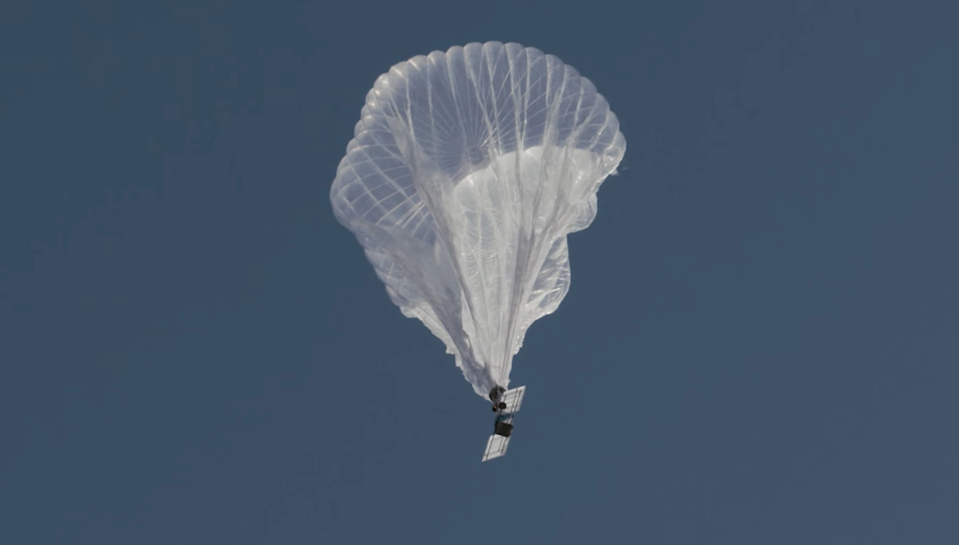
1. A balloon
Last week a balloon laden with a sophisticated package of electronics hovered 60,000 feet over the Moose Fire in Idaho. Its mission was to assist firefighters in improving and maintaining situational awareness. Some of them may have seen the shiny object the size of a football stadium, even though it was more than 11 miles above the incident.
The company that built and operates the aircraft, Aerostar, calls it STRATO, or Strategic Radio and Tactical Overwatch, a technology that is in the research and development phase.
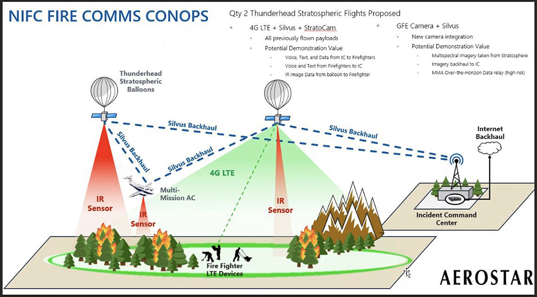
Illustration of how a Thunderhead Stratospheric balloon can assist wildland firefighters.
The STRATO is basically a giant mylar balloon with solar panels, batteries, radio equipment, cameras, and sensors. It has the capability to collect infrared and visual data, broadcast an LTE (cell phone) signal, has a high-band radio that can enable push to talk communications, and can operate a WiFi network. The huge helium balloon can hover over an incident in the stratosphere taking pictures, delivering data to incident managers, and providing communications options to the Incident Command Post and crews on the ground.
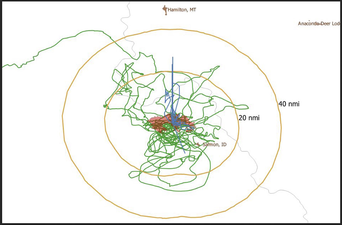
Flight path of an Aerostar Thunderhead Stratospheric balloon over the Moose Fire the week of August 7, 2022.
Last October Fire Aviation wrote about the system operated by Aerostar, a company based near Sioux Falls, South Dakota, which has been working with lighter than air technologies since 1956. We contacted the Communications Manager for the company, Lisa McElrath, who told us that in June, July, and August of 2021 they launched one of their Thunderhead Balloons from South Dakota and flew it west to monitor wildfires. While traveling more than 16,000 miles during its 70-day flight it engaged in station-seeking above four active fires for the company’s research and development. It collected visible and thermal imagery data for extended periods of time on the Robertson Draw Fire (Montana), the Dixie Fire (California), the Dixie-Jumbo Fire (Idaho), and the Dry Gulch/Lick Creek Fire (Washington).
In October we asked Ms. McElrath if Aerostar had been cooperating with the federal land management agencies in mapping fires. She said not yet, but that representatives from the National Interagency Fire Center had reached out to them and expressed interest in discussions after the fire season slowed down. But this year the US Forest Service is officially cooperating in the pilot project.
“We can provide real-time imagery from the balloon today in the visible and infrared,” Ms. McElrath said. “In the future, the goal would be to automate the detection and download of critical imagery, fire perimeters, likely fire-starts, and other key information via onboard processing so that more actionable information would be available. We see stratospheric balloon technology being the key to cost-effective, scalable wildfire surveillance that reduces time between new fire detection and response. Effectively, balloons can alert firefighters to a new fire while it is still small, before the fire grows into something newsworthy and very expensive.”
She said the balloons can also serve as radio repeaters for personnel on the ground and could collect information from tracking devices on firefighting resources which could then be displayed on a map.
More flights over fires are being planned, said Sean Triplett, Team Lead for Tools and Technology, U.S. Forest Service, Fire and Aviation Management. He said NASA is matching the funding the Forest Service is putting toward the flights this year.
2. Fixed wing aircraft
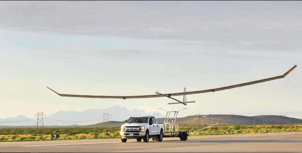
Swift Engineering’s SULE HALE-UAS. Swift Engineering photo.
Another High Altitude Long Endurance (HALE) aircraft the Forest Service is looking at is Swift Engineering’s SULE HALE-UAS, capable of staying aloft for more than 30 days at a time. The Forest Service, again partnering with NASA, has issued a contract with the company and as of March 31, 2021 they had conducted more than 10 demonstrations of the solar powered fixed wing aircraft.
The key to long duration flight using solar power on an airplane is to have a top surface area large enough for the solar cells needed to power the electric motors day and night, using a battery for night operations. Large wings mean more solar cells, but also more wind resistance. So the answer, using today’s technology, is to fly very high at 60,000 to 70,000 feet where the air is thin, the sunlight on the solar panels is strong, and there is less wind resistance.
The SULE, which took its first flight in July of 2020 has a 72-foot wingspan, operates at 70,000 feet, and can carry a payload of 15 to 22 pounds.
“A series of mid-altitude and high-altitude flights is being undertaken, Mr. Triplett told Fire Aviation on Wednesday. “At this point, the platform is only providing remote sensing products. However, if successful, additional systems may be incorporated.” Those added systems could include a radio system to provide connectivity enabling the tracking of firefighting resources on the ground in addition to live imagery of the fire.
Mr. Triplett said one advantage of having NASA as part of the project is that they can handle the airworthiness of the aircraft and interactions with the FAA.
The Swift Engineering video below shows what may be the first flight of the SULE two years ago.
A step toward the Holy Grail of Wildland Firefighter Safety?
Our view is that providing to wildland fire supervisors the real time location of both the fire and firefighting resources is the Holy Grail of Wildland Firefighting Safety. Lacking this information has led to at least two dozen firefighter fatalities. These High Altitude Long Endurance aircraft 13 miles above the fire could be an important link to transmit live video of the fire to personnel and provide radio connectivity enabling the tracking of firefighting resources on the ground even when they are in steep rugged topography. Of course the resources would need to have the hardware necessary to transmit the coordinates of their locations.
The John D. Dingell, Jr. Conservation, Management, and Recreation Act which became law March 12, 2019 required that by March 12, 2021 the five federal land management agencies “…develop consistent protocols and plans for the use on wildland fires of unmanned aircraft system technologies, including for the development of real-time maps of the location of wildland fires.”
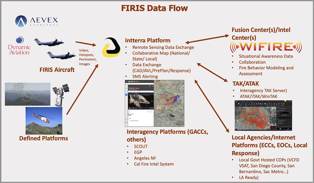
While this technology has been demonstrated, real time mapping appears to be far from being used routinely, at least within the Federal agencies. But at the state level, the Governor of California has requested $30 million in their next budget for 31 positions and funds for the state’s Office of Emergency Services to operate Real-Time Intelligence System (FIRIS) aircraft that have shown that they can provide real time fire mapping information. A pilot program for FIRIS first got off the ground September 1, 2019 thanks to funding secured in the 2019-2020 California state budget. This year two FIRIS ships have been assisting firefighters.
The Dingell Act also mandated that the five federal land management agencies “jointly develop and operate a tracking system to remotely locate the positions of fire resources for use by wildland firefighters, including, at a minimum, any fire resources assigned to Federal type 1 wildland fire incident management teams”, again, due by March 12, 2021.
Other solar powered high-altitude aircraft
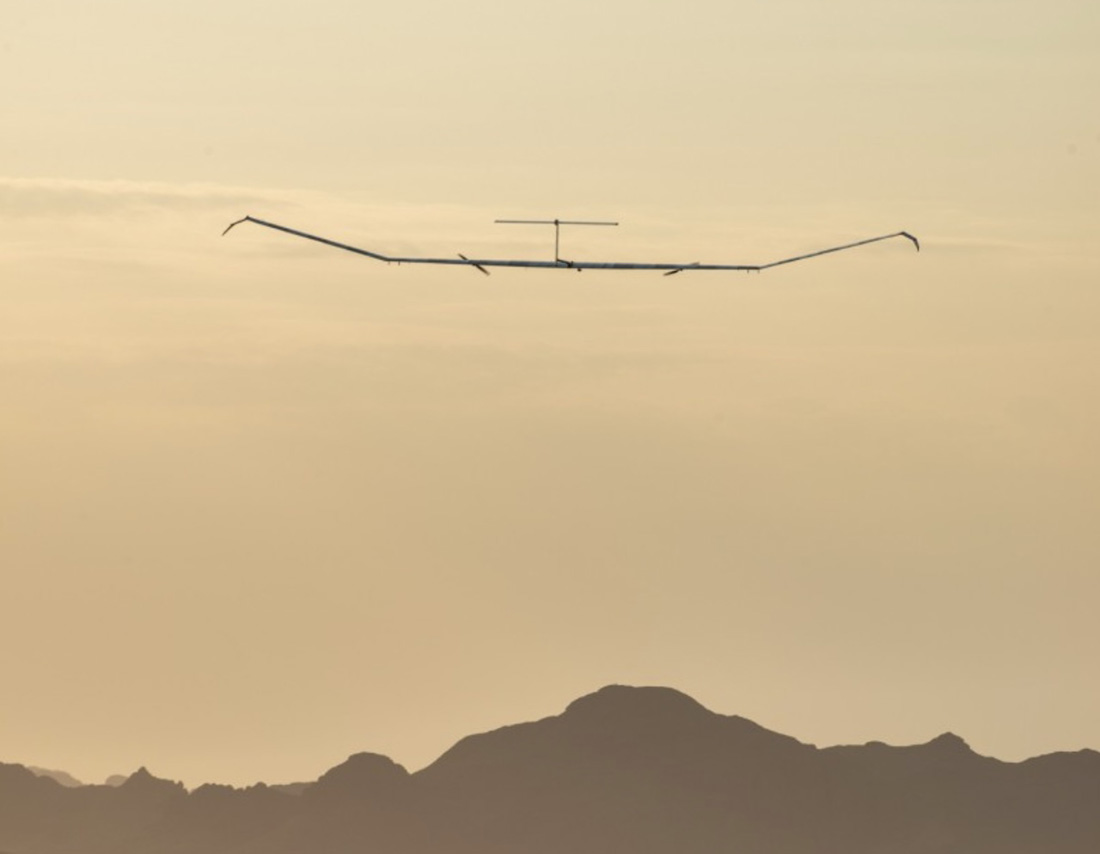
An aircraft that the Forest Service is not involved with is the Zephyr, made by AIRBUS. It is an unmanned, solar-powered fixed wing aircraft designed to stay aloft at high altitude for months.
AIRBUS Zephyr, stratospheric unmanned aerial vehicle. Airbus image.
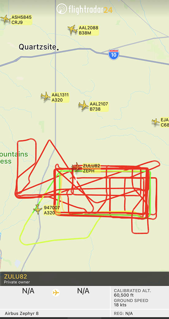
In its latest test flight that began June 15, 2022 the Zephyr took off from the U.S. Army’s Yuma, Arizona Proving Ground and has been flying patterns over the Yuma Test Range and Kofa National Wildlife Refuge ever since. Now 63 days later the flight has smashed Zephyr’s previous record of 25 days that it set in August 2018. When we checked August 17 it was cruising at 40 knots ground speed 70,500 feet above the Earth.
Flight path of ZULU82 Zephyr, a solar-powered unmanned aircraft on August 16, 2022, day 62 of a flight that began June 15, 2022.
UPDATE at 7:35 p.m. MDT August 21, 2022
The flight of the Zephyr has ended.
“Following 64 days of stratospheric flight and the completion of numerous mission objectives, Zephyr experienced circumstances that ended its current flight. No personal injury occurred,” AIRBUS said in a statement.
Simple Flying reported that a catastrophic loss of altitude occured on August 19 after flying for 64 days straight:
On its final day of operations, it was tracking around over the vast Arizona Desert, about halfway between Phoenix and Mexicali, Baja California. Flying slightly lower than was typical, at some 45,000 – 50,000 feet, it had completed an S-shape maneuver at around 50 – 60 knots when something went catastrophically wrong. ADSB data shows a vertical descent rate which rapidly increased, topping out at a speed of 4,544 feet per minute. Although unconfirmed by Airbus, it does seem that the Zephyr met a rather unglamorous end.
The Airbus Zephyr S during a 2021 test flight. US Army photo.
Evacuation at the Fort McMurray Fire in Alberta, Canada May, 2016.
The Department of Homeland Security hosted a proof-of-concept demonstration of the Wildland Urban Interface (WUI) integration model Monday, August 15, in Fairfax, VA. The model integrates next generation technologies with the Federal Emergency Management Agency Integrated Public Alert Warning System (IPAWS), enabling alerting authorities to disseminate Wireless Emergency Alerts with new capabilities such as displaying hazard and evacuation alert information on the “infotainment” screens in vehicles.
The DHS is working with partners to develop a new method for putting life safety alerts, such as evacuation alerts, into navigation applications during emergencies. Doing so will not only provide alerts to an increasingly mobile public, but also help the public make informed navigation decisions in all-hazard situations.
“Effective communication of emergency fire information and evacuation routes to people in an endangered area is a necessity for first responders striving to manage emergency operations and guide safe public response actions,” said Norman Speicher, Department of Homeland Security Science and Technology Directorate program manager. “Connecting emergency management tools to situations in the WUI will help emergency management officials achieve better routes and procedures by utilizing cutting-edge technologies that help define, share, and manage the status, and communicate evacuation routes and safety zones in real-time.”
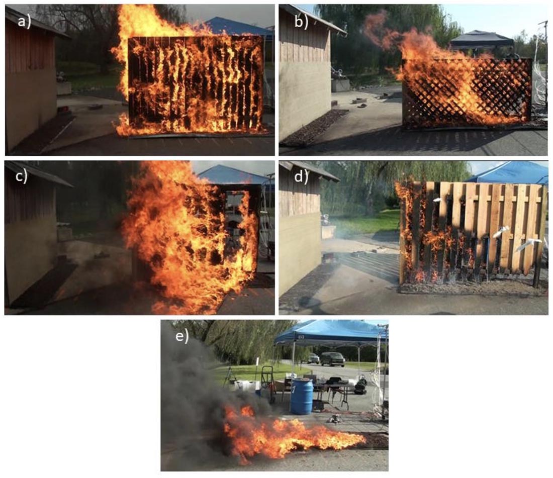
Examples of very high hazard fences and mulch: A) parallel privacy fences, B) double lattice fences, C) wood-plastic composite #1 fence, D) good neighbor fence, E) rubber mulch. (From the NIST research)
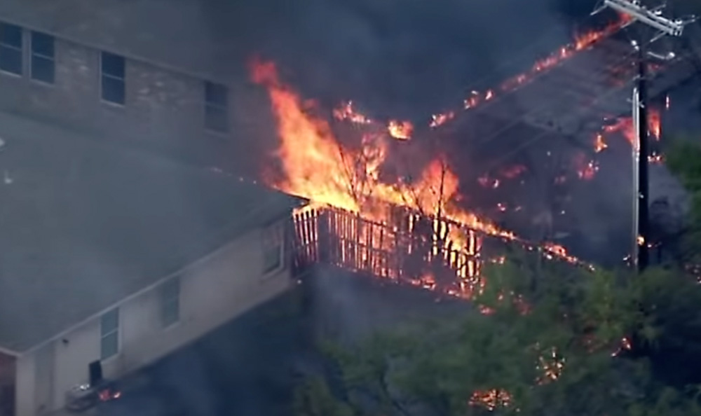
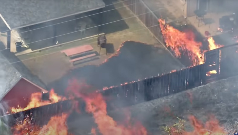
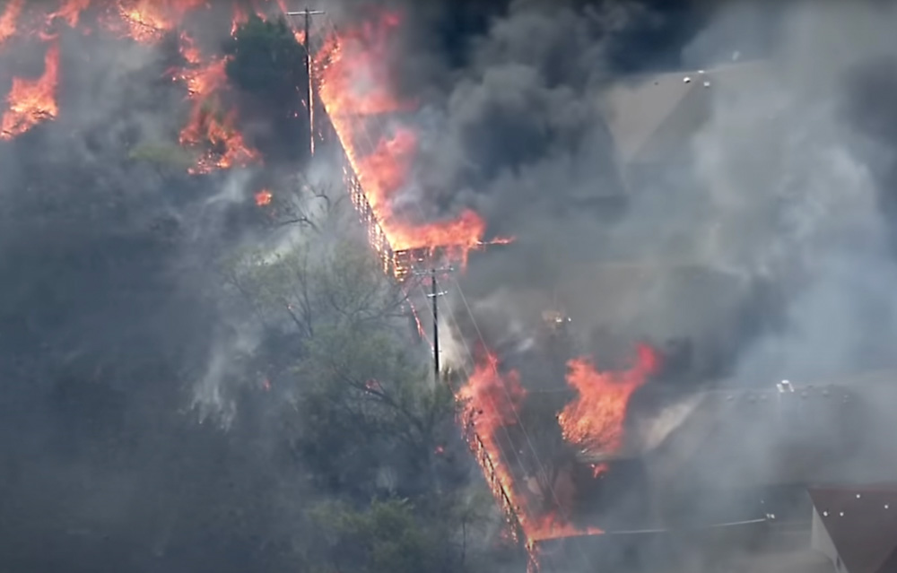
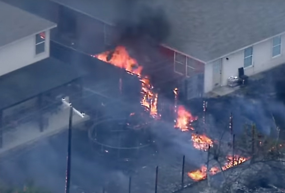
Three weeks ago a television station in Dallas, FOX 4, streamed live video as a grass fire spread across a field and reached densely-packed houses, eventually destroying 9 and damaging another 17. There were several reasons why the structures were so vulnerable, including medium-heavy vegetation in the field adjacent to the property lines, very little impact from efforts of the fire department to stop the spread, no air support, and wood fences that connected all of the properties on the rear and sides of the homes.
Parallel fences burn as grass fire spreads into neighborhood in Balch Springs, Texas, July 25, 2022. Image from video by FOX 4 Dallas-Fort Worth.
On August 10 the National Institute of Standards and Technology (NIST) published results of 187 experiments that examined how fire spread toward a structure is affected by combustible fences and mulch under conditions that may be encountered in a wildland-urban interface (WUI) fire. They looked at mulch only, fence only, fence plus mulch, parallel fences, and long range firebrands. The materials studied were western red cedar, California redwood, pine, vinyl, and wood-plastic composites. Fence styles included privacy, lattice, and good neighbor (board on board).
A small structure was located between zero and up to six feet downwind of the fence or mulch bed as a target for flames and firebrands. A target mulch bed at the base of the structure tested the ability of firebrands produced by the burning fence and mulch bed to ignite spot fires that threatened the structure.
While not many homeowners place store-bought mulch below their fences, it can be common for debris to build up along the base on one or both sides. The amount and flammability can be extremely variable, but the researchers’ use of mulch gave them control over the flammable material which could be consistently duplicated in their experiments.
The study found that firebrands capable of igniting spot fires downwind were generated by nearly all combinations of fence and mulch tested in this study. All wood fences with mulch at the base caused spot fires in the target mulch bed. Spot fires were often ignited within a few minutes of mulch and fence ignition. Shredded hardwood mulch and pine bark mulch burned and emitted firebrands for longer than an hour. Ignition of spot fires was also demonstrated from firebrands transported by the wind over distances as far as 156 feet from the burning item under high wind conditions and over a paved surface.
The research generated a number of recommendations:
Avoid parallel fences, to reduce exposure to large flames. Parallel fences can result in highly hazardous fuel accumulation corridors that are difficult to access and maintain. Spacing of 3 feet between fences is not sufficient.
Avoid proximity to other combustible fuels, to reduce fire intensity and limit fire spread. This includes fuels above the fence and fuels across parcel boundaries. Avoid mulch at base of fence.
Avoid proximity of combustible fences to residence, including neighboring residence, to prevent direct ignition.
Fire spread is more likely with wood and wood-plastic composite fences than with fences made of vinyl or noncombustible materials such as stone, brick, or steel.
Keep fence and yard clear of debris, to reduce the amount of fuel and potential pathways for fire.
Harden structures against firebrands to prevent structure ignition from embers produced by fences or other combustible sources.
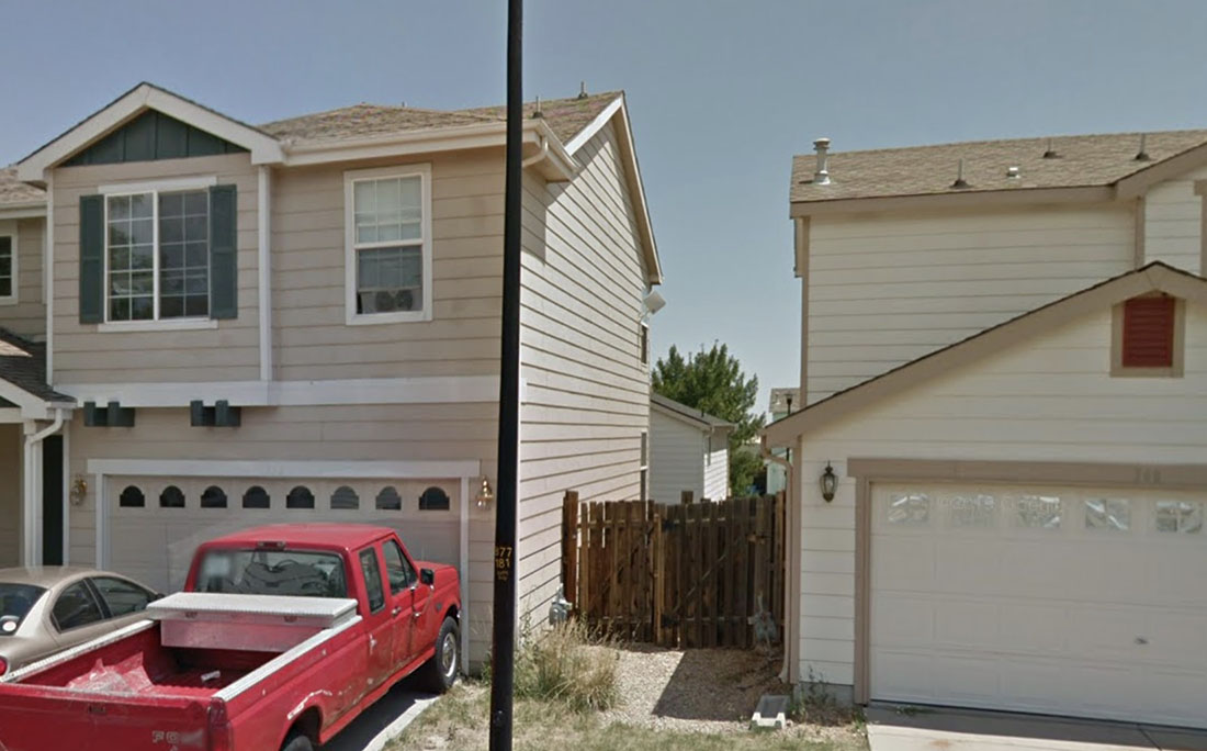
The video from the July 25 fire in Texas does not clearly show the fences between the residences, but it is likely that they directly connected to the structures. An example is seen in the photo below of two homes in Superior, Colorado, one of the communities devastated by the Marshall Fire that destroyed 991 structures south of Boulder December 30, 2021.
File photo of fence connecting houses in Superior, Colorado. July, 2012 Google image.
The images below are from the FOX 4 Dallas-Fort Worth video shot July 25, 2022.
Fences burn as grass fire spreads into neighborhood in Balch Springs, Texas, July 25, 2022. Image from video by FOX 4 Dallas-Fort Worth.Fences burn as grass fire spreads into neighborhood in Balch Springs, Texas, July 25, 2022. Image from video by FOX 4 Dallas-Fort Worth.Fences burn as grass fire spreads into neighborhood in Balch Springs, Texas, July 25, 2022. Image from video by FOX 4 Dallas-Fort Worth.
Most structures that burn in a wildfire are not ignited by direct flame impingement, but by burning embers that are lofted and carried downwind ahead of the fire. At Wildfire Today we first covered the role of embers in igniting structures in 2010, a concept brought into the public consciousness by Jack Cohen, a researcher at the Missoula Fire Science Lab. To reduce the chances of a home burning in a wildfire, the most bang for the buck is to concentrate on the Home Ignition Zone. The flammable material near the structure needs to be modified, reduced, or eliminated to the point where multiple burning embers landing in the zone will not propagate the fire and spread to the structure.
Person suspected of stealing solar panel and battery from Oregon DOF fire camera system August 14, 2022.
From the Jackson County, Oregon, Sheriff’s Office, August 16, 2022:
Jackson County Sheriff’s Office (JCSO) is investigating the theft of Oregon Department of Forestry (ODF) equipment stolen from a lookout tower in the Prospect area (map). Two men broke into the tower on Sunday afternoon August 14, 2022 around 12:45. The thieves stole batteries and solar panels used to power the lookout tower’s fire detection camera. With these items stolen, the camera is no longer operational, leaving a hole in the camera network and taking away the opportunity for early fire detection.
The ODF Southwest Oregon Detection Center is a system of cameras across Jackson and Josephine counties used to monitor rural areas in an effort to catch fires at a small size, provide critical fire information to firefighters responding to active incidents, and allow the department to use resources more strategically. This particular tower enables early fire detection for the northeastern portion of Jackson County near Prospect. ODF is currently working as quickly as possible to get the camera system back up and running. The list of items stolen includes batteries and solar panels to power the cameras.
If you can identify the subjects in the video and photos or have any information about the theft please call the JCSO Tip Line at (541) 774-8333 and reference case # 22-4725.
Solar panel that was stolen from Oregon DOF fire camera system August 14, 2022.Person suspected of stealing solar panel and battery from Oregon DOF fire camera system August 14, 2022.
There is also a video on Facebook showing two people climbing the stairs to the lookout.
“As soon as we found out, we started re-ordering all of the batteries, solar panels and specialty pieces that make this system run, but the bad news is a lot of these things are hard to come by and shipping can take some time,” said the Oregon DOF. “Getting the site back up and running is one of our top priorities, but in the meantime, we have firefighters out patrolling the area to make sure we’re still finding fires quickly and keeping them small.”
Red Fire 3-D map, looking south at 12:35 p.m. Aug. 14, 2022.
The Red Fire in Yosemite National Park in California has burned 416 acres since it started from a lightning strike on August 4, according to a mapping flight Monday morning. It is in a remote and rugged section of the park about 12 miles northeast of Wawona and the Washburn Fire which burned nearly 5,000 acres very close to the Mariposa grove of giant sequoias in July.
The national Situation Report Monday morning showed a small group of resources assigned — five people with one fire engine. They are being led by Jenn Anderson, a Type 4 Incident Commander.
The crew is assessing natural barriers, such as granite, to confine and contain the fire, rather than fully suppress the blaze. There are no trail closures or threats to infrastructure.
Red Fire map, 12:35 p.m. Aug. 14 2022.
It is very close to the Mariposa/Madera County line and about five miles from the park boundary. So far the fire has been burning at about 8,300 feet above sea level, mostly in the footprint of the 2001 Hoover Fire. If it spreads further to the east it will leave that fire scar and move into an area with no fire history within the last 30 years, but there is a great deal of granite in that direction. (see the 3-D map at the top of the article) There are no giant sequoia groves within several miles of the fire, which was a major concern during last month’s Washburn Fire.
Red Fire, image by FIRIS mapping aircraft. Looking west at 8:53 a.m. PDT Aug. 15, 2022.
A satellite flyover at 1:38 p.m. PDT Monday detected only a few large heat sources, all on the east half of the fire. There are no doubt many smaller burning areas that could not be detected by the sensors orbiting hundreds of miles above the Earth.
Red Fire, posted August 13, 2022 by Yosemite National Park.Red Fire, posted August 14, 2022 by Yosemite National Park.