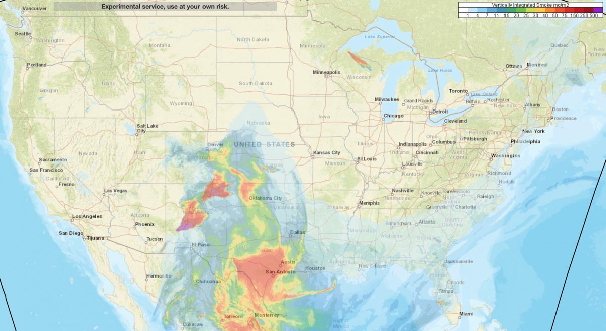
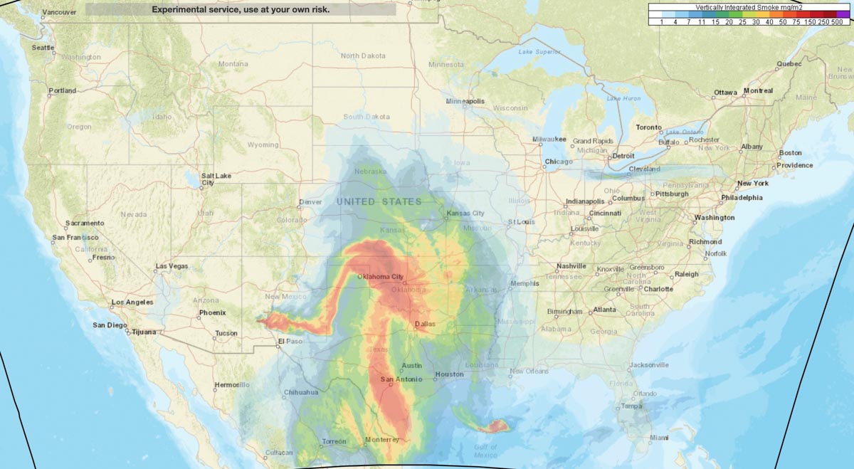
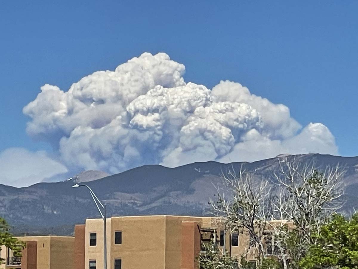
Large quantities of smoke from the Black and Calf Canyon Fires in New Mexico is impacting other states, including Texas, Oklahoma, Colorado, and Kansas.
News and opinion about wildland fire

Large quantities of smoke from the Black and Calf Canyon Fires in New Mexico is impacting other states, including Texas, Oklahoma, Colorado, and Kansas.
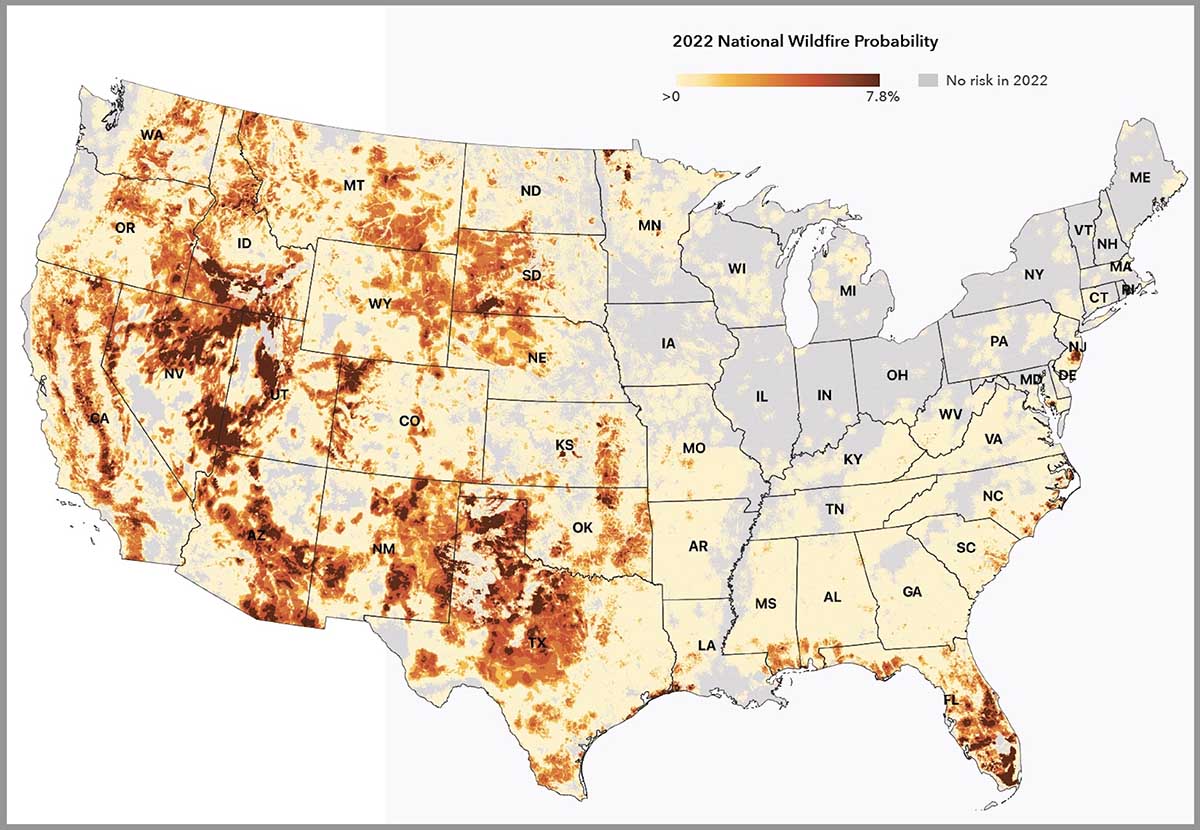
An organization has developed a system for calculating the wildfire risk of 145 million properties this year and 30 years from now.
The First Street Foundation’s Risk Factor is a free source of probabilistic wildfire risk information where anyone can enter a street address and within seconds see the risk for both wildfires and floods at that location.
We tested the system by entering property addresses for two locations that were severely impacted by recent wildfires.
The text below is how the First Street Foundation describes their rating system for wildfire risk:
There has long been an urgent need for accurate, property-level, publicly available environmental risk information in the United States based on open source, peer reviewed science. In a mission to fill that need, First Street Foundation has built a team of leading modelers, researchers, and data scientists to develop the first comprehensive, publicly available risk models in the United States. Beginning with flood and now wildfire, First Street works to correct the asymmetry of information in the market, empowering Americans to protect their most valuable asset–their home while working with industry and government entities to inform them of their risk.
METHODOLOGICAL OVERVIEW
The First Street Foundation Wildfire Model integrates information on fuels, wildfire weather, and ignition into a Fire Behavior Model. The wildfire model requires data on the combustible fuels which may contribute to wildfire across the United States. The 2016 update, Version 2.0.0, of the canonical U.S. Forest Service (USFS) LANDFIRE (LANDFIRE, 2021) fuels dataset at the 30 meter resolution serves as a baseline of this fuels estimate, and that dataset is updated by including additional information of all known “disturbances” between 2016 and 2020 which could modify or change the fuels in a way not captured in the original dataset. These “disturbances” include activities such as recent wildfires, prescribed burns, harvests, and other forest management practices.
Another important and novel update included in the First Street Foundation Wildfire model is the reclassification of homes and other buildings from a “nonburnable” fuel type to a “burnable” fuel type. Typically, homes and other buildings are classified as nonburnable fuel types within LANDFIRE v2.0.0. In order to allow the wildfire behavior model to more accurately estimate how wildfire moves through the Wildland-Urban-Interface (WUI), properties within the WUI must be replaced by a burnable fuel type so as to not block the modeled wildfire spread.
To represent a wide range of possible weather-driven wildfire conditions across the landscape within the simulations employed here, the model utilizes a decade of NOAA weather data, the 2011-2020 Real Time Mesoscale Analysis (RTMA) dataset (NOAA/NCEP, 2022) augmented by data from Oregon State’s PRISM dataset (Parameter-elevation Regressions on Independent Slopes Model; PRISM, 2021).
These weather data include hourly surface wind, air temperature, relative humidity, and precipitation information at the 2.5 km horizontal resolution. This weather data supports a wide range of possible weather conditions, not to recreate any particular wildfire events, but to drive the wildfire behavior model millions of times in a Monte Carlo simulation scheme to derive 2022 wildfire hazard estimates.
Similarly, for 2052 the same weather time series was used to drive the simulations, but the air temperature, humidity, and precipitation were bias-adjusted to 2052 conditions following the CMIP5 RCP4.5 ensemble results. Rather than applying a bias-adjustment to the wind time series for the future climate, the same winds from the 2011-2020 time series were used to drive the 2052 simulations to reduce sensitivity of the model to highly uncertain future predictions of winds.
One of the primary indicators of where future wildfires will occur is informed through data on historical wildfire occurrences. These historical wildfires help to inform where wildfires may occur vis-à-vis the Fire Occurrence Database (FOD) developed by the USDA Forest Service (Short, 2014; Short, 2021). An open source wildfire behavior model was used, ELMFIRE (Eulerian Level Set Model of Fire Spread). This work does not develop new techniques for wildfire modeling, but rather implements computationally efficient and scalable modeling techniques at a high resolution based on existing science, wildfire probability, and hazard modeling paradigms. These scalable techniques make it practical to more easily conduct wildfire simulations at the 30 meter resolution across the entire country, enabling property and building specific assessments of wildfire risk.
For each 30 meter pixel across the country, information is recorded on the distribution and occurrence of burn incidence, flame lengths experienced, and the relative amount of embers which land in the pixel. These provide estimates of:
Burn probability: the estimated likelihood of the area burning during any single year.
–Fire intensity: estimated flame lengths, including maximum, average, and sum of all flame lengths experienced.
–Ember exposure: the relative amount of embers which land in an area due to nearby simulated wildfires.
Updated at 4:18 p.m. MDT May 16, 2022
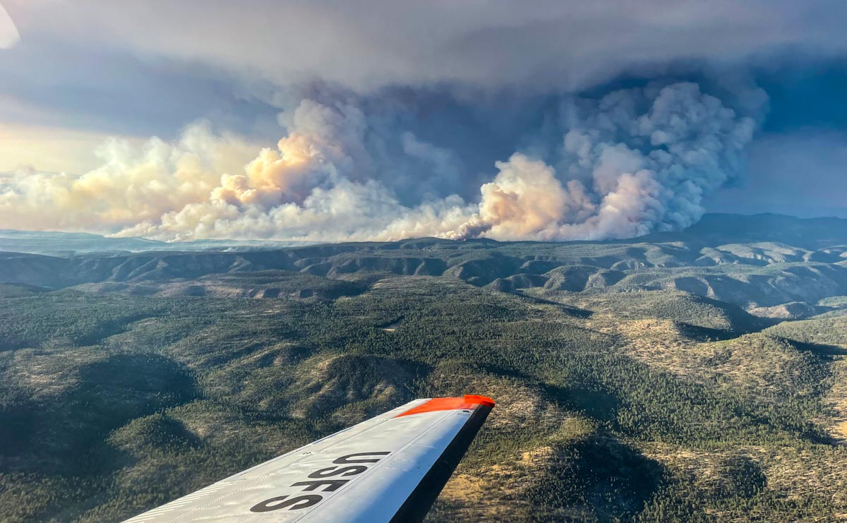
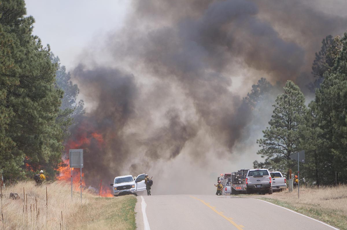
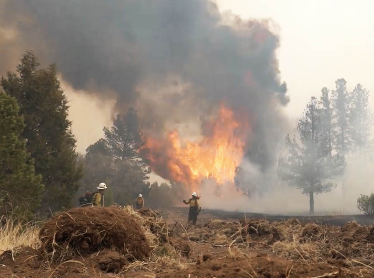
The Black Fire 31 miles north-northeast of Silver City, New Mexico is very active Monday afternoon, as seen in these photos.

10:22 a.m. MDT May 16, 2022

The Black Fire 31 miles north-northeast of Silver City, New Mexico made an impressive run to the east Sunday. Fire officials said that morning it was 1,174 acres; when it was mapped by an aircraft that night at 9:04 it had grown to 18,762 acres and was 11 miles long. Satellite data at 3:26 Monday morning indicated that it had continued to spread vigorously to the east through the night.
It is burning in timber and tall grass in the Gila National Forest 34 miles west of Interstate 25 and Truth or Consequences.

The rapid growth of the fire Sunday was due to dry fuels, relative humidity that dropped to 2 percent, and 10 mph winds gusting to 22 out of the west-southwest. The data was recorded at the Gila Center weather station.
The weather forecast for Monday near the fire at 6,800 feet calls for 18 mph winds gusting out of the southwest at 28 mph, 86 degrees, and 4 percent relative humidity — conditions that could lead to additional spread to the northeast.

9:35 a.m. MDT May 15, 2022
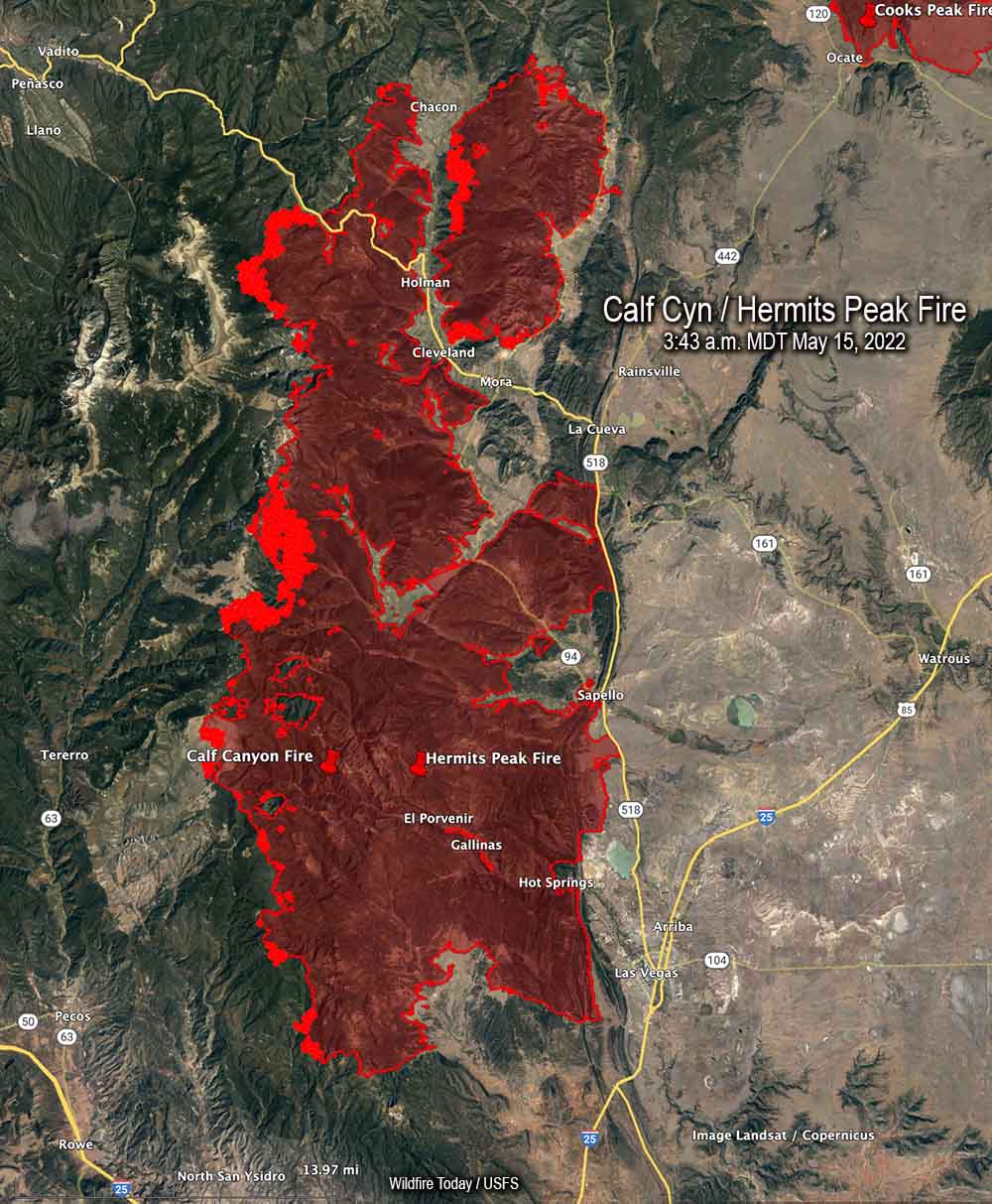
The spread of the Calf Canyon / Hermits Peak Fire in Northern New Mexico has slowed in recent days compared to the rapid spread seen early last week during very strong winds and ultra low humidity.
The fire was mapped Saturday evening at 288,942 acres. Most of the activity at that time was on the west flanks, and on the north side near Holman, Chacon, Cleveland, and Mora. Crews are working to keep it away from structures and are putting in additional firelines. The perimeter on the east side between Las Vegas and La Cueva has been secure for several days.
Three Incident Management Teams are assigned. The Southwest Incident Management Team 3 (SWIMT3) has assumed command of the southern half of the fire. The SWIMT 1 took management of the northern half, and the California IMT 2 will work to the north on a bigger-picture strategic plan for control, identifying additional locations where containment lines may be constructed.
The weather forecast for Sunday is west to southwest winds 15 to 20 mph, with gusts to 25 on the north and central zones. Temperatures will range from the upper 60’s to mid-80’s depending on the elevation, with a minimum relative humidity 7 to 11 percent. Even though the wind speeds are not extreme the fire will remain active, with critically dry fuels and near-record high temperatures.
There is very little fire history out in front of the Calf Canyon – Hermits Peak Fire in Northern New Mexico
9:09 p.m. MDT May 13, 2022
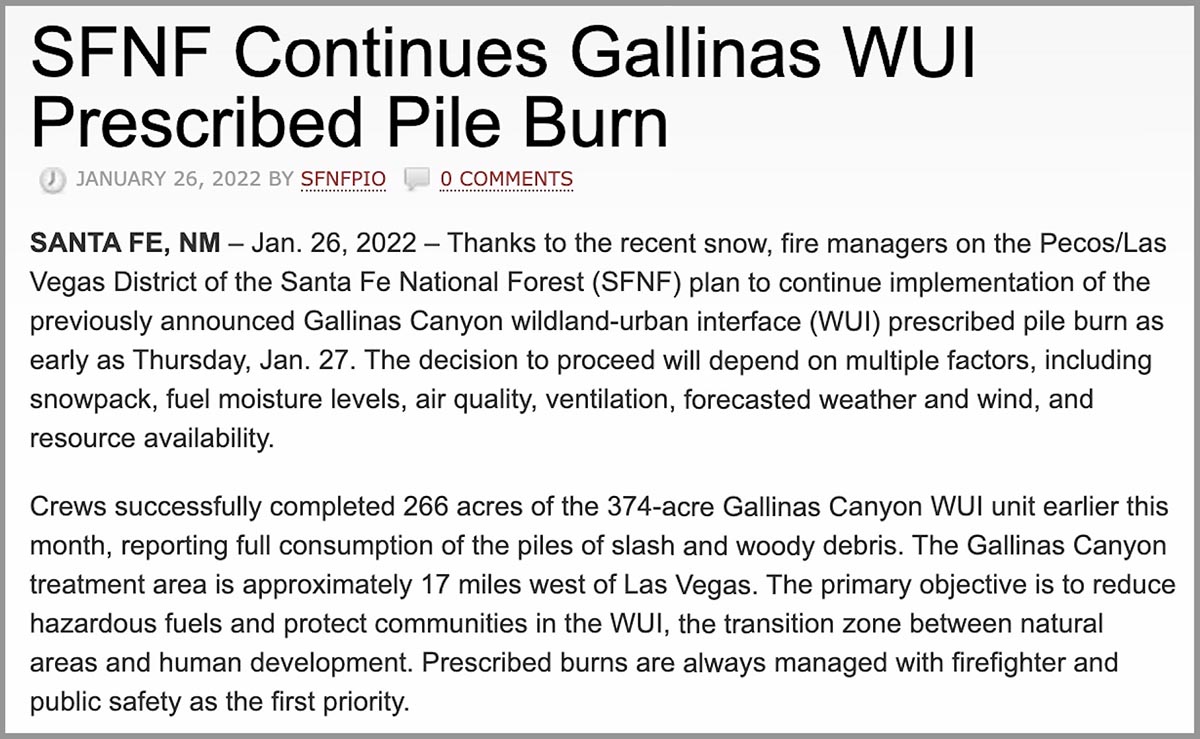
About three months before the Calf Canyon Fire was reported April 19, 2022, employees of the Santa Fe National Forest ignited hundreds of acres of debris piles which were created during fuels treatment projects. The piles were “approximately 17 miles west of Las Vegas,” according to a notice posted at the New Mexico Fire Information website on January 26, 2022. (See below) The name of the project was Gallinas Canyon wildland-urban interface (WUI) prescribed pile burn. In January prior to the notice crews had already completed 266 acres of the 374-acre unit and planned to continue burning more piles “as early as January 27.”
Fires are usually named after a geographical feature near the point of origin. Calf Canyon Road intersects with Forest Road 263 which is in Gallinas Canyon.
On September 27, 2012 a 300-acre hazardous fuels reduction mechanical thinning project was finished just north of Calf Canyon Road, which likely left hundreds of piles to burn later.
This project and Calf Canyon Road are broadly within the general area where the Calf Canyon Fire started. There have also been other fuels treatment projects in that area over the last 10 years.
To see all articles on Wildfire Today about the Calf Canyon and Hermits Peak Fires, including the most recent, click here.
The US Forest Service has already identified an escaped prescribed fire as the cause of the Hermits Peak Fire, but lists the cause of the Calf Canyon Fire as under investigation.
Wildfires, prescribed fires, and pile burns are known to have smoldered for months, sometimes under snow and through an entire winter, before being discovered months later when smoke becomes visible. The burn piles were at approximately 8,000 feet, so the snow reported in the notice may have kept the vegetation cold and wet for a couple of months if the pile burning was completed in February. We are not saying that is what caused the Calf Canyon Fire, but investigators have no doubt evaluated that possibility and ruled it in or out.
Three days after the Calf Canyon Fire was reported strong winds and low humidities combined to caused it to merge with the Hermits Peak Fire and spread 10 miles to the northeast through dry vegetation in a 24-hour period.
What is next for the Calf Canyon / Hermits Peak Fire?

While the Calf Canyon / Hermits Peak Fire has been churning through more than 270,000 acres on its march to the north, at least 90 percent of those acres have burned in areas with no recorded history of previous fires in the national database, going back decades. If that spread to the north and north-northeast continues there is limited significant fire scars in the records out ahead that will slow the fire. (Update May 14, 2022: The NIFC database does not include two fires north of the Calf Canyon / Hermits Peak Fire; the 2020 Luna Fire (10,100 acres) and the 2018 Sardinas Canyon Fire (2,300 acres), according to the link provided in a comment by SE.)
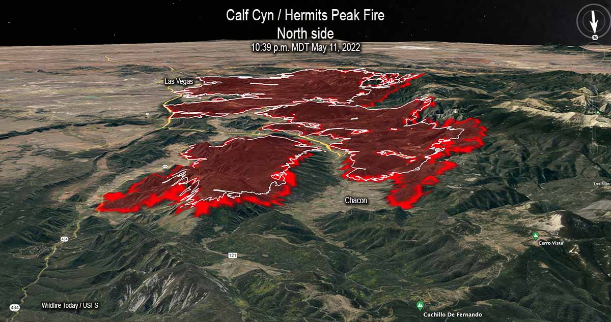
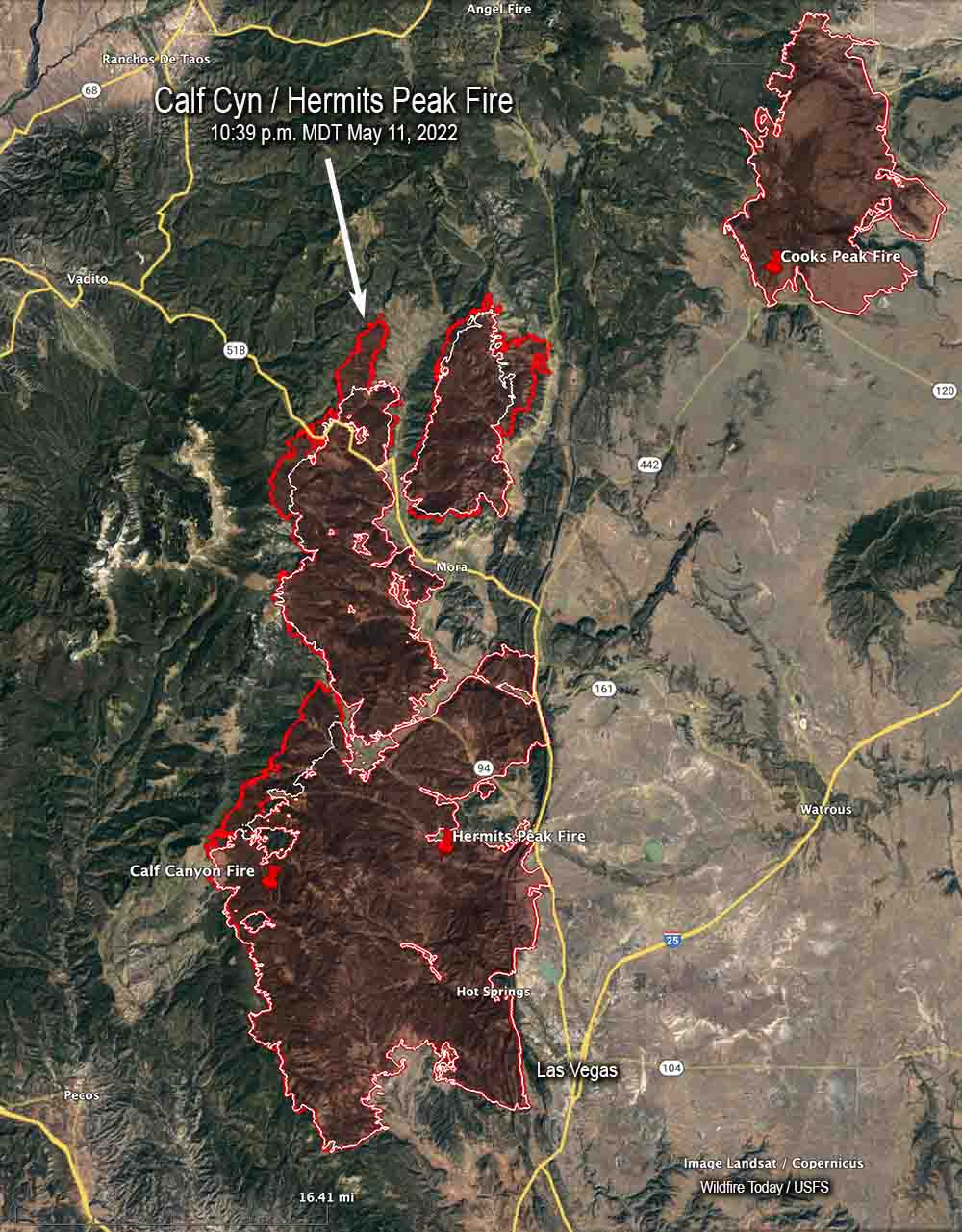
The overall length of the fire is 45 miles as of Thursday night May 12. From the origins they ran north for 32 miles, and south for 13.
There are also no large completed fuel treatment projects in the national database north of the fire that could serve as barriers, except for several near US Highway 64 west of Angel Fire near Valle Escondido 14 miles away. But there are other fuels treatment projects at what is now the southeast corner of the fire in the Barillas Peak area. It has just started to burn into the 2,534-acre “Wildfire Commissary 2015” fire use fire, but it is possible that without too much trouble it could work its way around it, another smaller fire use incident, and a 600-acre prescribed fire conducted in 2004.
At the end of the day on May 12 the north end of the fire was 14 miles from US 64, 19 miles from Taos, 11 miles from the Cooks Peak Fire, and 25 miles from the Philmont Scout Ranch.
Most of the growth of the Calf Canyon – Hermits Peak Fire Wednesday was on the north end where it spread for one to three miles further north and northeast. As of Wednesday night at 10:39 it remained west of Highway 434. It increased by about 22,000 acres Wednesday to bring the total up to 259,810 acres.