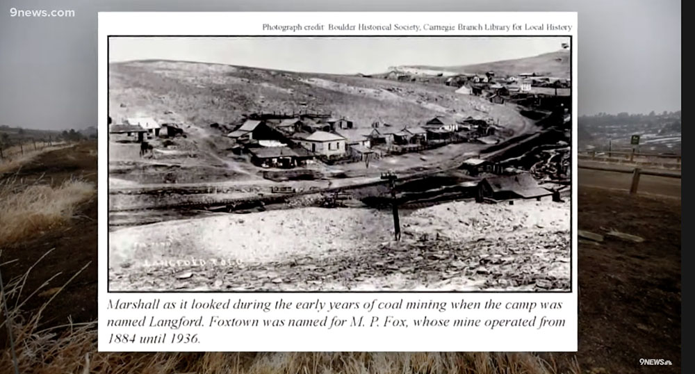
Coal mine at Marshall, Colorado, 1884 until 1936. 9News
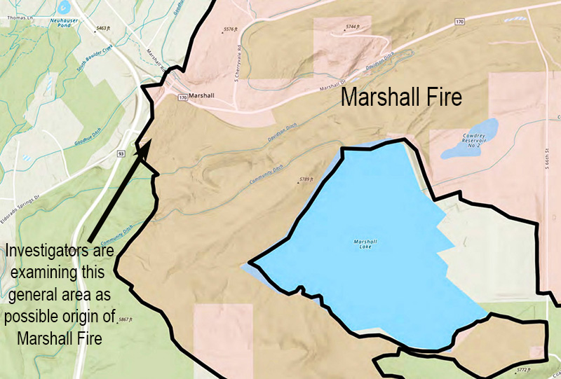
A television station in Denver, 9News, has found that in the general area where investigators are narrowing down the origin and cause of the Marshall Fire northwest of Denver an underground coal seam has been burning since the 1870s.
In December, 2005 after a portion of the burning seam emerged on the surface and started a vegetation fire the Office of Surface Mining advised the City of Boulder, which owns the land, “It would be prudent for the City of Boulder to remove any vegetation from surface cracks, as well as begin a long term maintenance and monitoring program for the area.” In 2005 the spread of the fire was stopped quickly.
The City hauled in 275 tons of gravel with the intention of least insulating the fire from the surface. But these underground fires have a habit of creeping their way back up and too often ignite fires. They are next to impossible to extinguish.
9News reported that the M. P. Fox mine in the area operated from 1884 until 1936.
Pushed by winds gusting at 60 to 100 mph, the Marshall Fire spread rapidly as it destroyed more than 1,000 homes. Most were in the city of Louisville and the town of Superior.
The 9News video below has more details.
On a different topic, but related to the Marshall Fire, we learn in the next video that 17 of the houses that were in the burned area but survived have been sold.
Yesterday the Black Hills National Forest began the final phase of mitigating the downed trees, the fuels, left after a tornado passed through Spearfish Canyon along highway 14A between Cheyenne Crossing and Savoy southwest of Deadwood, South Dakota. There are about 200 piles (from Moskee Road to Sand Creek to Williams Gulch) that crews are planning to burn over the next few days.
The first photo shows the area after the tornado. The second shows piles of debris created so they could be burned later. In the third, one of the piles is surrounded by snow, and finally, they are being burned.
Igniting the fuels while there is snow on the ground greatly reduces the chances of escaping and igniting a wildfire.
Photo credit: US Forest Service / Josh Hoffmann.
2. Piles constructed to burn later.3. Pile surrounded by snow.4. Burning of piles began January 25, 2022.
The rapidly spreading blaze destroyed more than 1,000 homes northwest of Denver December 30
Investigators are looking at an old coal mine as the possible cause of the Marshall Fire northwest of Denver, Colorado. Decades ago miners were extracting coal from an area near the location where the Marshall Fire started December 30, 2021. The remaining coal has been burning for years even though dozens of tons of fill were hauled in with the intention of stopping the burning, or at least insulating the fire from the surface. But these underground fires have a habit of creeping their way back to the surface and too often ignite a vegetation fire.
The old mine near the intersection of Highway 93 and Marshall Drive near the town of Marshall is one of 38 active underground coal fires in Colorado. In 2002 a burning underground coal seam ignited vegetation near Glenwood Springs, Colorado which burned 29 homes and more than 12,000 acres.
Wildfire Today had an article in 2008 about an 8-year-old boy who suffered burns on his foot when he walked into an area of Golden Hills park in Colorado Springs, Colorado that was covered in coal dust. Left over from coal mining operations about 80 years earlier, the dust was on fire, smoldering, and it melted the boy’s plastic shoe and gave him second degree burns. If the boy had not “discovered” the fire, it would have spread into nearby vegetation. The cause of the fire was unknown.
Pushed by winds gusting at 60 to 100 mph, the Marshall Fire spread rapidly last month as it destroyed more than 1,000 homes. Most were in the city of Louisville and the town of Superior.
Equipment more sensitive than a conventional spirometer was able to detect lung damage
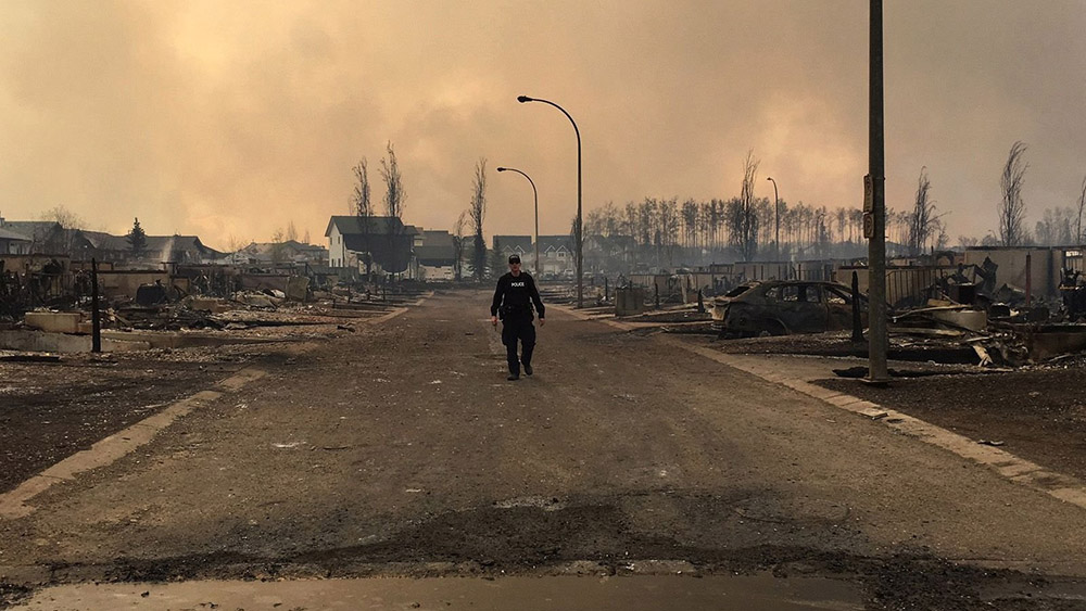
A police officer walks past burned homes in Fort McMurray, Alberta, Canada May 5, 2016. AFP photo / Alberta RCMP / HO
A study on the health of Royal Canadian Mounted Police (RCMP) officers who were deployed in Alberta, Canada in 2016 to the Horse River Fire at Fort McMurray found that their airway function was compromised in the first three months after deployment. An analysis of health data from 218 officers revealed that the small airways in their lungs underwent structural changes after they were deployed, potentially increasing their risk for respiratory diseases in the future. The median exposure duration of the officers was eight days.
“We cannot tell from our study whether it’s long-lasting damage, but we do know from other studies that if people are exposed to high levels of particulate matter in the air, they are more likely to suffer from long-lasting damage to the lungs,” said Paige Lacy, professor of medicine at the University of Alberta and former director of research for the Alberta Respiratory Centre.
The Horse River Fire caused the largest evacuation in Canadian history, with more than 80,000 people rapidly removed from the community as fires encroached on the city. Hundreds of RCMP members were sent to the community to assist with the evacuation and to secure the area in the following days. The fire burned 589,552 hectares (1.4 million acres) in 2016 and destroyed 2,400 structures. The extreme fire behavior created lightning in the pyrocumulonimbus cloud atop the smoke column that started a number of new wildfires 40 kilometers (26 miles) ahead of the main wildfire front according to a report released in June of 2017.
These two fires started at about the same time on May 1, 2016 near Fort McMurray, Alberta, Canada. On the left is the MMD-004 fire inside the city limits of Fort McMurray. The Horse River Fire, often referred to as the Fort McMurray Fire, is on the right.
Subtle changes in lung function detected
The lung-function data were gathered as part of a larger study being conducted by Synergy Respiratory and Cardiac Care, looking at the health of RCMP officers dispatched to the Fort McMurray wildfire. According to the researchers, the subtle differences in lung function that were found were not measurable using traditional lung-function tests, and could only be observed through the use of more sensitive instruments. Researchers employed both spirometry and body plethysmography testing methods.
“Small airways are potentially more vulnerable and there is no way that a spirometer (a device commonly used to measure lung function) can detect the progression of their damage over time,” said Subhabrata Moitra, first author on the study and a post-doctoral fellow in the U of A’s Division of Pulmonary Medicine. “So if we use highly sensitive instruments, we can immediately get some signals whether there are any acute yet subtle changes caused by physiological factors or occupational or environmental hazards.”
The researchers noted that because the officers only came in for testing once after being deployed, they were not able to observe potential recovery of lung function or measure long-term damage.
The authors of the study pointed out the importance of having a health-surveillance program in place so responders who are exposed to such hazards can have their health monitored.
Survey finds that firefighters also complained of respiratory issues
A survey found that some firefighters who fought the fire at Fort McMurray also battled respiratory and mental health issues.
The University of Alberta study surveyed 355 firefighters and found a “very large proportion” of them complained of respiratory issues including coughing, breathlessness, wheezing and chest tightness in the immediate aftermath of the fire.
“When we saw them later, probably about one in five of those still had problems with their chests that they felt had been caused or made worse by the fire,” said Nicola Cherry, the epidemiologist leading the study.
And they’re battling more than just physical ailments — mental-health issues affect one in six of study participants.
“When we collected this information, it was early days and people may develop bigger issues as time goes forward,” Cherry said.
Our Take
It is likely that wildland firefighters are routinely exposed to far higher concentrations of smoke and for longer periods of time than the RCMP officers at Fort McMurray. It is important that agencies who employ wildland firefighters establish a health-surveillance program that includes lung function tests using methods such as body plethysmography that are much more sensitive than a conventional spirometer.
The Nacimiento guard station, two fire engines, several personal vehicles, and two dozers burned — there was one very serious injury
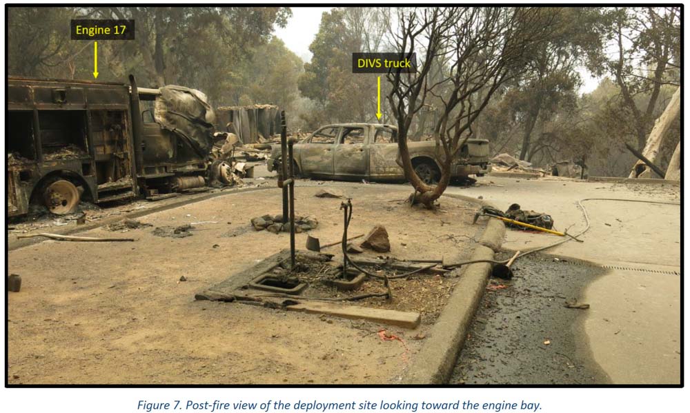
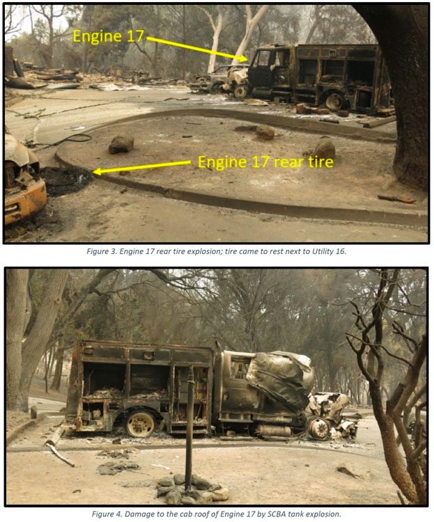
Dolan Fire deployment site. Engine & pickup. Image from the report
Several “learning reports” have been released by the U.S. Forest Service about the burnover and entrapment one and a half years ago of wildland firefighters at a remote fire station. It occurred on the Dolan Fire on the Los Padres National Forest in Southern California September 8, 2020. Fifteen firefighters deployed into only 13 fire shelters. Four firefighters were injured and three were hospitalized. One had very serious burns.
The Dolan Fire had been burning for weeks but there were about half a dozen other fires in California that were larger, some much larger such as the LNU Lightning Complex, SCU Lightning Complex, CZU August Lightning, and the August Complex.
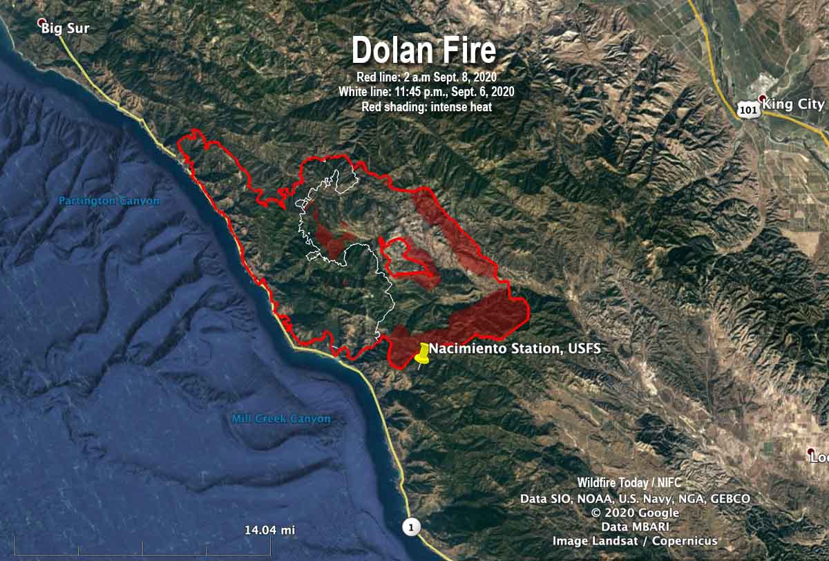
The Incident Management Team ran a modeling scenario on September 4 which showed that within the next 14 days the probability of the fire reaching the Nacimiento Guard Station was 60 to 80 percent with no delaying tactics. At that time the fire was 3.1 miles away.
The night before the fire reached the station on Nacimiento-Fergusson Road 7 miles from the highway on the California coast, the fire ran for about three miles toward the station, burning 30,000 acres with spot fires three-quarters of a mile ahead. The map below based on infrared data shows the growth in the 26-hour period ending at 2 a.m. on Sept. 8. The fire hit the station between 7 and 8 a.m. on September 8.
Map of the Dolan Fire. The red line was the perimeter at 2 a.m. PDT September 8, 2020. The white line was the perimeter about 26 hours earlier. The red shaded areas indicate extreme heat.
When the fixed-wing aircraft mapped the fire five or six hours before the incident, it had burned about 74,000 acres, more than twice the size mapped the previous night. The sensors on the plane detected intense heat on the southern edge of the fire, 0.7 miles north of Nacimiento Station.
The fire personnel at the station during the burnover included two USFS engine crews, two dozers with operators, and the only Division supervisor working the night shift — due to a shortage of personnel. Other overhead at the fire may have been distracted as a newly established Incident Command Post had to be evacuated and relocated as the fire approached in the middle of the night.
Dolan Fire deployment site. Engine 17. Image from the report.
Several of those involved at Nacimiento believed there was no way to defend the station even though a hand crew had cleared some vegetation, a hand line had been dug, and there were hose lays around the structures. With that work done and the fact that the station had survived other fires, some of the locals said they could protect the buildings and the personal belongings and vehicles of the fire personnel who lived there.
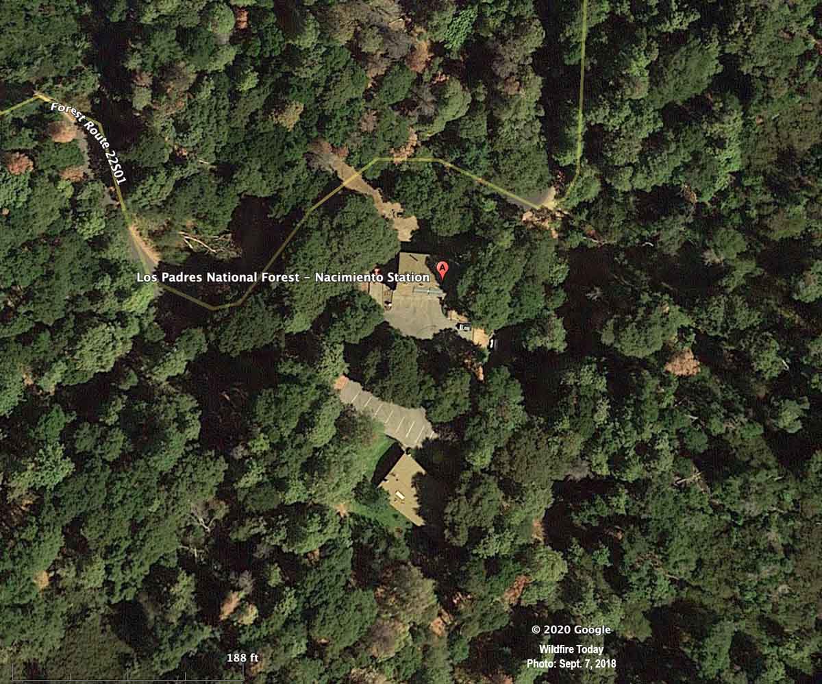
Below is an aerial photo of the Nacimiento Guard Station taken almost exactly two years before the burnover. It appeared in an article on Wildfire Today about the entrapment published September 11, 2020.
Nacimiento Station, satellite photo, September 7, 2018.
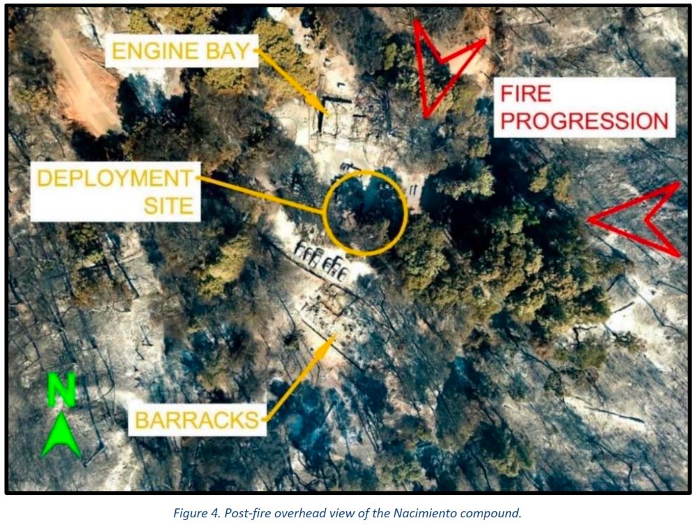
The photo below was taken after the burnover.
Dolan Fire deployment site, aerial photo. Image from the report.
This is the first paragraph in the Learning Review — Narrative:
Smoke is billowing out of the barracks and hot embers are raining down all around. Engine 16 is on fire. The engine bay is on fire. Marty can’t get his pack out of the burning engine, which means he can’t get to his fire shelter. He’s just standing there, and Rene can’t get his attention. She has her shelter out, ready to go. She hits him, but he just stands there. She hits him again, but he still just stands there. Marty is not ready to commit to the shelter; he’s thinking about potential dangers from the propane tanks around them, and that more needs to or could be done. Rene hits him again and pulls down on his shirt to get him down to the ground and into the fire shelter. Rene tucks the fire shelter around him and cinches it in tight under his arms and legs. She takes a quick look around and then climbs in under the shelter with him. Eleven other firefighters are deployed around them in the parking lot of the Nacimiento guard station. The heat inside the shelters was stifling. “I could feel the skin tightening on my face. Mucous was coming out of my nose and eyes, hanging off my chin. I felt like all the fluid was being roasted out of me. My throat was so sore I could barely drink my water.” Everyone is asking the same question: “How did we get here?”
“If we preach it, we should do it.”
The Organizational Learning Report has a section, Theme 3, pointing out that even though the Forest Service has “preached [to homeowners] FireWise concepts for decades” about how to reduce the chances of their houses burning as a wildfire approaches, too many of the agency’s own structures lack FireWise status. The report says, “If we preach it, we should do it. ”
We asked Kelly Martin for her thoughts about the reports on the Dolan Fire. She is the current president of Grassroots Wildland Firefighters and the retired Chief of Fire and Aviation for Yosemite National Park. She replied by text:
The biggest thing that comes to mind is our over confidence in what we deem ‘defendable’ until the time wedge becomes too small to make safe, proactive decisions. The oppressive personal/social pressure to protect treasured places puts us in an untenable situation to champion the notion, ‘not on my watch’ are we going to lose this place. The protection narrative gets repeated and reinforced by the majority who consider it ‘their home turf’ and unfortunately tend to dismiss many ‘outsiders’ objective perspectives on the situation that might help reduce the deep personal attachment to ‘home turf.’ Having ‘Outsiders’ become part of the decision making process can help enhance rational decision making.
Confirmation bias may have been a factor. The fire station survived previous fires, thus lulling us to previous events rather than fully appreciating the situation we now find ourselves in with excessive fuel buildup.
Also, I think the Wildfire Decision Support System (WFDSS) process and further high level local management and Incident Management Team analysis should have spotted this mindset trap early on.
Our Take
The disaster at the Dolan Fire is yet another example where knowing the real-time location of the fire may have made a difference. The Captain who ran the station and some other locals believed that they needed to protect the facility and insisted that they COULD. Others thought differently but were not assertive enough or didn’t have the authority to override that decision. They knew the fire was approaching. But would things have turned out differently with others who didn’t have emotional attachments to the buildings? Or who had real-time intelligence, and could “see” the locations of all resources as well as the entire fire — the very rapid rate of spread, the spot fires ¾ mile ahead, and the intensity? What if the Operations Section Chief, Branch Director, primary Safety Officer, or the Incident Commander had access to real-time video from a drone circling over the fire? Any one of those might have ordered the withdrawal of the engines, dozers, and 15 firefighters hours before they came close to death. They might have said, “Forget the damn structures. Think about the humans. Consider the physical and mental trauma those humans could suffer, perhaps for years.”
The decision to stay or go, in addition to human safety, should have also considered the dollar value of the personal belongings and vehicles of the employees who lived at Nacimiento. They were not evacuated days earlier even though the station was in a mandatory evacuation area. They trusted the Incident Management Team, the Forest overhead, and the Captains. How much will it cost those firefighters, on their meager salaries, to replace their personal vehicles and belongings? Then there is the cost to taxpayers of two engines, two dozers, and at least one pickup truck.
The technology has existed for years to provide real-time video of fires 24 hours a day. The John D. Dingell, Jr. Conservation, Management, and Recreation Act required that by September 12, 2019 the five federal land management agencies “develop consistent protocols and plans for the use on wildland fires of unmanned aircraft system technologies, including for the development of real-time maps of the location of wildland fires.”
While this technology has been demonstrated and used sparingly, such as the FIRIS program, real-time mapping is far from being used routinely.
The Dingell Act also mandated that the five federal land management agencies “jointly develop and operate a tracking system to remotely locate the positions of fire resources for use by wildland firefighters, including, at a minimum, any fire resources assigned to Federal type 1 wildland fire incident management teams,” due by March 12, 2021.
The Bureau of Land Management has installed hardware for Location Based Services (LBS), which are now operational on more than 700 wildland fire engines, crew transports, and support vehicles. Vehicle position and utilization data are visually displayed via a web-based portal or mobile device application. Ten months after it was required by Congress, the U.S. Forest Service has made very little progress on this mandate.
Some other government facilities are also not FireWise
It is not just the Forest Service with structures that do not all meet FireWise standards. When I was an area Fire Management Officer for the National Park Service, two of the parks for which I was responsible were threatened on different occasions by wildfires. Although the threat was low to moderate, I was able to convince the Park Superintendents that hazard reduction and thinning of the trees was necessary, now. It should have already been done, but seeing smoke in the air made it possible to make fast decisions and to get it accomplished very quickly. Up until then, removing any tree near park headquarters was a tough row to hoe. Neither fire spread into the parks, but the long-delayed and badly needed work got done. And I slept better.
At Del Rosa fire station in Southern California the VP was introduced by a wildland firefighter
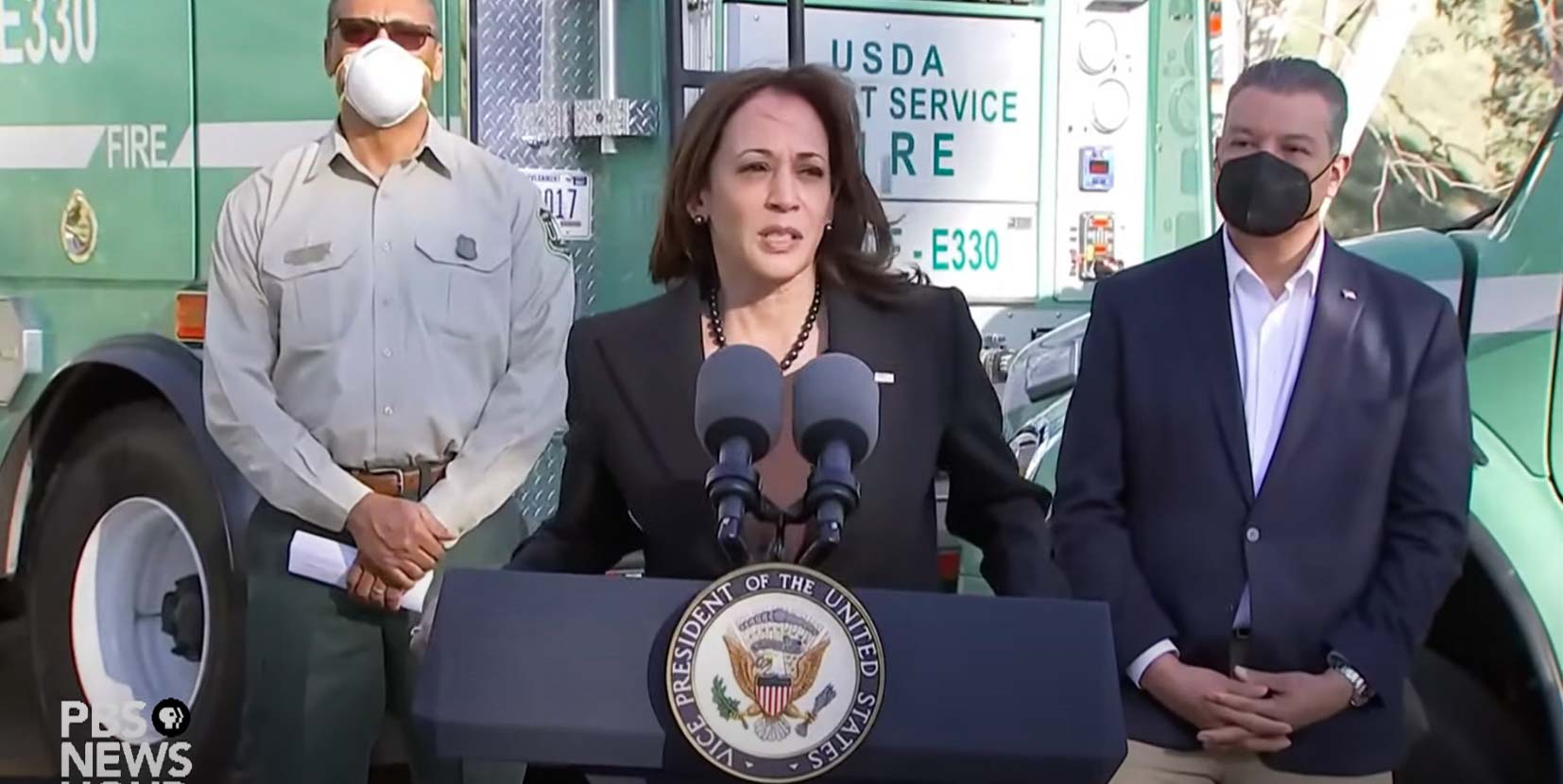
Vice President Kamala Harris at the San Bernardino National Forest, January 21, 2022.
On Friday Vice President Kamala Harris traveled to California where she spoke about wildland fires and the fact that federal firefighters are “underpaid given the nature and value of their work.”
Her 12-minute speech was made at Del Rosa fire station on the San Bernardino National Forest as she stood in front of US Forest Service fire apparatus, Engine 330 and a Del Rosa Interagency Hotshot crew buggy.
“On behalf of the President and myself I want to thank all the men and women who serve in such difficult times but always with such grace. Thank you Sarah and thank you Chief,” the Vice President said as she began her remarks. Sarah Hudson, a firefighter, introduced the VP. More about that below.
Later the Vice President mentioned the pay of federal wildland firefighters.
“There will be $5 billion, and more actually,” she said, “for wildfire preparedness and resilience, and it will include, and this requires its own conversation, a pay raise for our federal firefighters. And I invite everyone to become familiar with the history of this issue and for how long they have been underpaid given the nature and value of their work, and so we are very, very excited to acknowledge their work not only in words but with the pay that recognizes the value of the skill and the dignity of the work that they perform…And I am very proud of the folks who in particular are on the ground doing this work every day. As I have said before I will say again, you inspire us all.”
The Vice President spoke for 12 minutes about wildland fire and reducing their impact, and never mentioned raking the forest.
She also covered the resilience of communities threatened by fire.
“We are talking with home owners and reaching out to communities,” she said, “to figure out how we can support them to create a community that is less likely to be so significantly damaged if a fire should hit.”
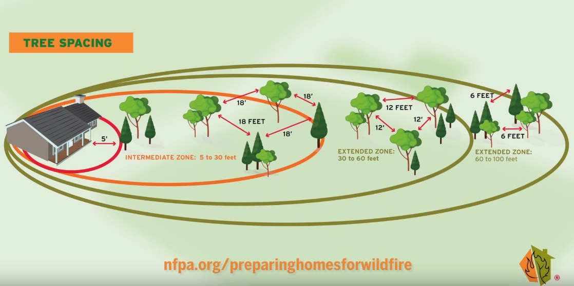
The Home Ignition Zone should be an extremely high priority in preventing structures from burning as a wildfire approaches.
“Surprisingly, research has shown that home ignitions during extreme wildfires result from conditions local to a home,” wrote retired US Forest Service Research scientist Jack Cohen in a 2020 article on Wildfire Today. “A home’s ignition vulnerabilities in relation to nearby burning materials within 100 feet principally determine home ignitions. This area of a home and its immediate surroundings is called the home ignition zone (HIZ). Typically, lofted burning embers initiate ignitions within the HIZ – to homes directly and nearby flammables leading to homes.”
Other speakers at the event included Secretary of Agriculture Tom Vilsack, California Governor Gavin Newsom, and Chief of the Forest Service Randy Moore.
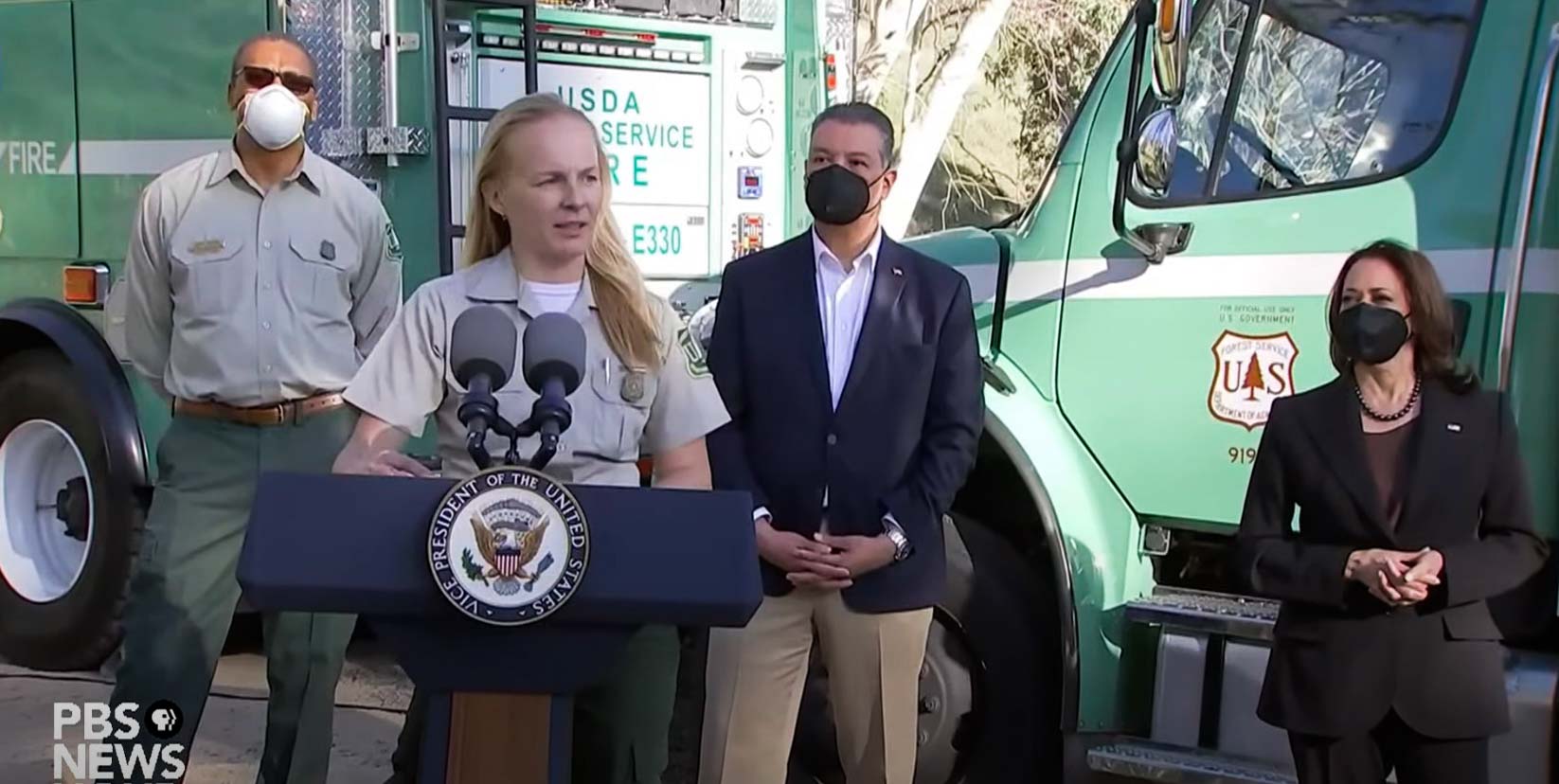
Sarah Hudson, a US Forest Service firefighter with Heaps Peak Helitack, introduces Vice President Kamala Harris, January 21, 2022.
In addition to the dignitaries peaking at the event, Sarah Hudson, a senior firefighter on the Heaps Peak helitack crew on the San Bernardino National Forest made remarks and then introduced the Vice President. This may be the first time a wildland firefighter has performed such a feat. In her spare time Ms. Hudson serves in the California National Guard as a senior airman with the 163rd Attack Wing where she performs maintenance on ground support equipment for remotely piloted aircraft such as the MQ-9 Reaper. On several occasions a National Guard Reaper or similar National Guard drone have assisted firefighters by gathering real time imagery over ongoing wildfires in California.
The entire 35-minute event is covered in the video below.