Forecasters predict the potential for large wildfires will be higher than average on the west coast this summer

Areas to watch will be Northern California and the west sides of Oregon and Washington

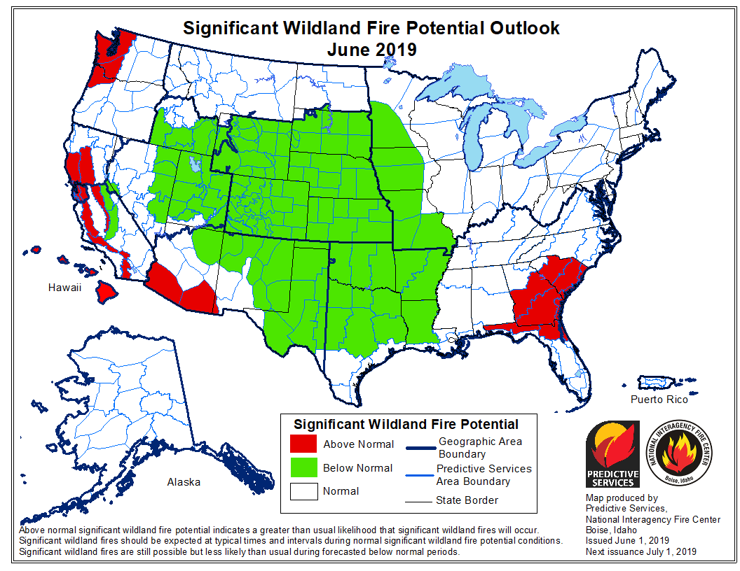
June wildfire potential

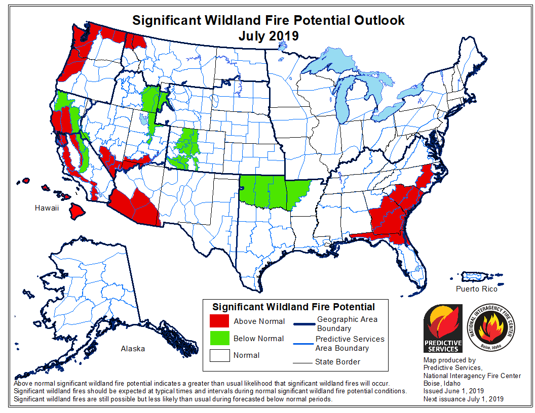
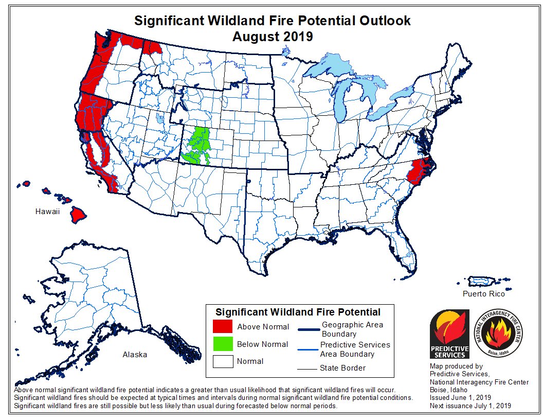
On June 1 the Predictive Services section at the National Interagency Fire Center issued their Wildland Fire Potential Outlook for June through September. The data represents the cumulative forecasts of the ten Geographic Area Predictive Services Units and the National Predictive Services Unit.

If NIFC’s analysis is correct, the areas with above normal wildfire potential on the western sides of Washington, Oregon, and California will expand during the four-month period until they cover most of the forested lands in California as well as northern Washington and Idaho. Forecasters predict portions of Florida, Georgia, and the Carolinas will have enhanced potential in June and July.

The areas affected by  the multi-year drought in the West have greatly decreased to the point where there are no locations with extreme or exceptional drought. Northwestern Oregon is classified as “severe drought” and this could be an area to watch over the summer months.

Below:

  • An excerpt from the NIFC narrative report for the next several months;
  • More of NIFC’s monthly graphical outlooks;
  • NOAA’s three-month temperature and precipitation forecasts; and,
  • Drought Monitor.
  • Vegetation greenness maps

From NIFC:
“…As June progresses, the fine fuels will begin to cure and dry from south to north across the West. Lingering high elevation snowpack should be lost. Wildfire activity should begin to increase by late month as peak of the fire season begins to arrive as July and August approach. As is the case with the lower elevation fuels, the high elevation heavy fuels will also experience a delayed entry into the season except along the Canadian Border in Washington State where overall dryness will lead to an average start with a potential for above normal activity. Alaska will reach its peak in June and begin to wind down in July.

“Looking ahead to August and September the fire potential and resulting activity should increase to Normal in most areas except along the West Coast where Above Normal significant large fire potential is expected due to fuel loading and preexisting dry conditions. A traditional winding down of the Western fire season is expected in Mid-September as fall moisture begins to arrive…”

July wildfire potential

August wildfire potential

Continue reading “Forecasters predict the potential for large wildfires will be higher than average on the west coast this summer”

Canadian wildfire smoke spreads into the Eastern U.S.

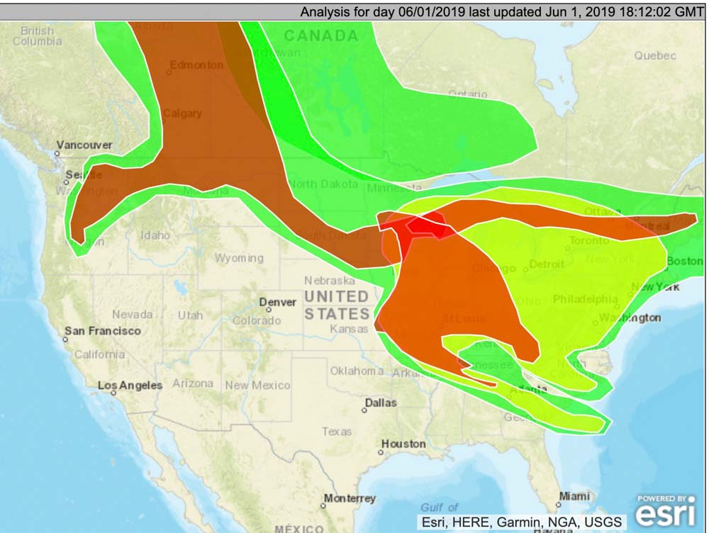
map wildfire smoke noon MDT June 1, 2019
The distribution of wildfire smoke at noon MDT June 1, 2019. NOAA, Office of Satellite And Product Operations.

On Saturday smoke from the wildfires in Alberta, Canada was affecting parts of Washington, Oregon, Montana, North Dakota, Missouri, Minnesota, Iowa, South Dakota, and most of the states east of the Mississippi River — plus the Canadian provinces of Alberta, Saskatchewan, and Manitoba.

Below is the smoke forecast for Sunday at noon MDT June 2, produced by the Canadian government. Unfortunately it does not include the entire U.S.

wildfire smoke forecast June 2, 2019
The smoke forecast for Sunday at noon MDT June 2, produced by the Canadian government.


Senators to followup on bill passed to enhance safety of wildland firefighters

“Firefighters lives are as important as soldiers.” Bill Gabbert, 2018.

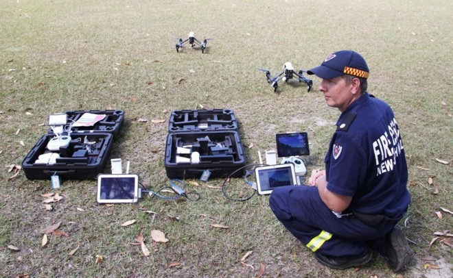
FRNSW drone
Fire and Rescue New South Wales photo

Next week there will be a fire management technology “Expo” in Washington, D.C. to introduce Senators to emerging technology that can aid wildland firefighters.

Fourteen months after it was first introduced, the Wildfire Management Technology Advancement Act became law after it was included in an omnibus bill, the Natural Resources Management Act. The Senate passed it with a vote of 92 to 8, and the House followed suit, 363 to 62. On March 12, 2019 it was signed by the President.

Now that the legislation has become Public Law 116-9 the federal land management agencies are directed to adopt or build on a number of new technologies that can enhance the safety of firefighters and aid in the suppression of wildfires.

The Expo scheduled for June 5 will give approximately eight to twelve proponents or vendors of new technology time to explain what these new systems can do. Then the Senators and their staffs will be able to individually talk with the representatives and examine the exhibits and displays the companies brought that will be lining the walls of the Senate hearing room.

Several of the technologies expected to be featured are listed below.

Later in June the Committee will convene their annual hearing where representatives of the land management agencies will bring the Senators up to date on their plans for managing wildfires this year. And importantly, the Senators, then fresh from their brief seminar on new technologies, will be able to discuss how the agencies are progressing on implementing the technology directives that they are now required by law to implement, many of which have due dates.

The key points in Public Law 116-9 have requirements for the Secretaries of Interior and Agriculture. The completion dates were established from March 12, 2019 when the legislation was signed.

      • Establish a research, development, and testing program, or expand an applicable existing program, to assess unmanned aircraft system technologies, including optionally piloted aircraft, across the full range of wildland fire management operations. (180 days, due by September 8, 2019)
      • Develop consistent protocols and plans for the use on wildland fires of unmanned aircraft system technologies, including for the development of real-time maps of the location of wildland fires. (within 180 days, March 12, 2020)
      • Develop and operate a tracking system to remotely locate the positions of fire resources, including, at a minimum, any fire resources assigned to Federal Type 1 wildland fire incident management teams. (within 2 years, March 12, 2021)  According to a press release by Senator Maria Cantwell, by the 2021 fire season, all firefighting crews – regardless of whether they are federal, state, or local – working on large wildfires will be equipped with GPS locators.

In October, 2013 we first wrote about what we called the Holy Grail of Wildland Firefighter Safety. It is a system that could track in real time the location of firefighters AND the fire, all displayed on one screen. This data should be available in real time to key supervisors and decision makers in the Operations and Planning Sections on fires. Knowing the positions of personnel relative to the fire would be a massive step in improved situational awareness and could reduce the number of firefighters killed on fires. Too often firefighters have been surprised, overrun, and sometimes killed by a rapidly spreading wildfire when they did not know where the fire was and/or their supervisors did not know the correct, actual location of the personnel.

Not everyone on a fire would need to monitor the location data all the time, but at least one person should be given the responsibility to be sure that a rapidly spreading wildfire does not overrun the location of firefighting resources. Darkness, smoke, and terrain can obscure the location of the fire from firefighters on the ground.

Wildfire smoke from Canada moves farther into United States

Air quality is affected

wildfire smoke map north america
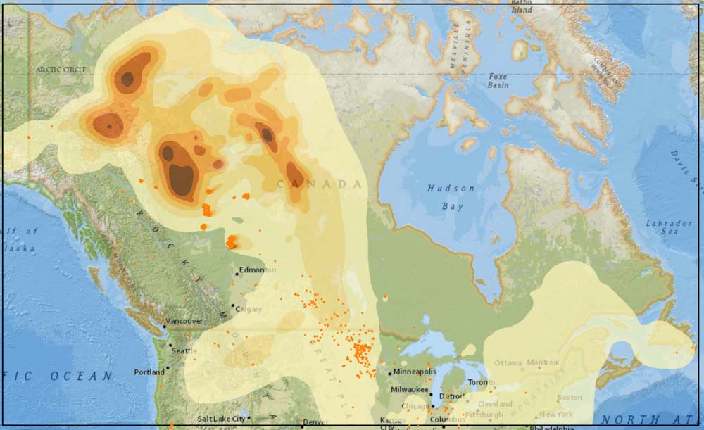
The distribution of wildfire smoke across North America. By NOAA, Office of Satellite And Product Operations.

Smoke created in Alberta by wildfires over the last week, but especially on Wednesday when extreme fire weather caused major fire growth, is moving farther south into the United States.  Much of the northern tier of states has significant quantities of smoke and it reaches as far south as Colorado and Kansas, with lighter concentrations in Oklahoma and Arkansas.

Montana is particularly affected according to AirNow, with Helena having “Unhealthy” air quality Friday morning. Lewiston and Great Falls are rated at “Unhealthy for Sensitive Groups”.

But it is much worse in the Canadian provinces of Alberta, Saskatchewan, and Manitoba. For example, the air quality in Calgary is maxed out on the nasty air scale, rated at “Very High Risk”.

Calgary Air Quality, May 31, 2019
Calgary Air Quality, May 31, 2019. Government of Canada.

Unfortunately, NOAA’s Office of Satellite And Product Operations that produced the smoke map is having problems with their website and it is not possible to confirm with 100 percent confidence how current the mapped smoke data is. But we’re thinking it represents the distribution of smoke as of Friday morning. Hopefully NOAA can get this glitch fixed.

Chuckegg Creek Fire in Alberta grows to over half a million acres

Will it become a million-acre “gigafire”?

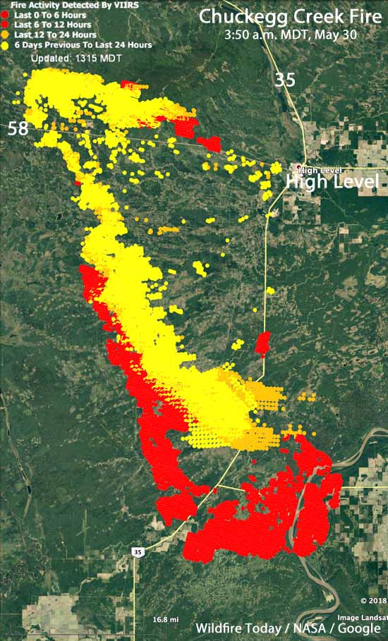
Map Chuckegg Creek Fire Northern Alberta
Map of the Chuckegg Creek Fire in Northern Alberta at 3:50 a.m. MDT May 30, 2019. The shaded areas represent heat detected by a satellite during the previous seven days.

The Chuckegg Creek Fire in Northern Alberta near the town of High Level was very active over the last 48 hours while being pushed by strong winds. Exhibiting extreme fire behavior, it grew to the south about 11 miles, and while moving 12 miles to the east it crossed Highway 35 and jumped the Peace River both north and south of the ferry crossing on Highway 697.

Alberta Wildfire estimated it has burned 230,000 hectares, or 568,000 acres.

Below is an excerpt from an update by Alberta Wildfire about the Chuckegg Creek Fire, issued May 30, 2019:

The Chuckegg Creek Fire experienced extreme fire behaviour yesterday with significant growth to the south towards Paddle Prairie, across Highway 35 by Highway 697 and spotted across the Peace River. Continued hot and dry conditions along with variable, gusty winds have proved a challenge to firefighting efforts and safety. Municipal firefighters and heavy equipment responded, with structure protection established as possible to the south of the fire. The fire also experienced growth to the west and continued fire activity on the north part of the fire around Watt Mountain.

Firefighters, heavy equipment, and aircraft are assessing the situation given the recent fire growth and will focus on priority areas. Structural protection and municipal firefighters are working to protect values. The weather forecast today anticipates cooler temperatures and higher minimum relative humidity, though winds today are expected to remain gusty and are expected to come primarily from the north.

I believe that the fire started during the week of May 12. It reached the 100,000-acre threshold to become a “megafire” on May 20. Now that it has easily grown to 568,000 acres, I wonder if it will reach a million acres to become a “gigafire”. A bushfire that started October 11, 2018 in Western Australia 120km southeast of Broome burned 880,000 hectares, or 2,174,527 acres.

The weather for the next seven days at the fire’s location will be variable, with a chance of rain on Saturday, Monday, and Thursday of next week, so there will not be many days conducive to explosive fire growth.

Maps: wildfire smoke conditions and forecast

wildfire smoke map north america
The distribution of wildfire smoke across North America, May 30, 2019. By NOAA, Office of Satellite And Product Operations.
wildfire smoke forecast map
Forecast for the distribution of wildfire smoke at 5 a.m. MDT May 31, 2019. By NOAA Earth System Research Laboratory.

Here is how the NOAA Office of Satellite And Product Operations described the smoke conditions at 10:36 a.m. MDT May 30, 2019:

“Northwestern to Western Canada/South Central Canada/Southeastern
Canada/Northern New England…

“Large complex wildfires are continuing to burn and be observed over Northern Alberta Province and through portions of Northwestern Canada. Several smaller fires are burning and being observed as well in South Central Canada. Heavy density smoke is being observed in the region of the large complex wildfires and has been transported with the low level flow South and Eastward down into South Central Canada, into North and South Dakota, and into the Northern Upper Midwest Region. Moderate density smoke is being observed throughout most of Alberta Province, Northwestern Canada, South Central Canada, the High Plains, the Midwest, Ontario, and into Upstate New York. Light density smoke has been observed throughout most of Northwestern Canada, South Central Canada, the Plains, Midwest, the Southern Great Lakes region, Northern New England and progressing into far Southeastern Canada. The smoke is expected to continue to progress South and East over the day.”