FSU researchers: Most fires in Florida go undetected

By: Zachary Boehm

A new study by Florida State University researchers indicates that common satellite imaging technologies have vastly underestimated the number of fires in Florida.

Holmes Nowell
Christopher Holmes, assistant professor in the department of Earth, Ocean and Atmospheric Science, and Holly Nowell, postdoctoral researcher in EOAS.

Their report, published in collaboration with researchers from the Tall Timbers Research Station and Land Conservancy, challenges well-established beliefs about the nature and frequency of fire in the Sunshine State. While there were more fires than expected, researchers said, strategically prescribed burns throughout the state are proving an effective force against the ravages of wildfire.

The paper appears in the journal Geophysical Research Letters.

For scientists studying fire, sophisticated satellites whizzing far above the Earth’s surface have long represented the best tool for monitoring wildfires and prescribed burns — carefully controlled and generally small fires intended to reduce the risk of unmanageable wildfires.

But FSU researchers suggest that fire experts themselves have been getting burned by faulty data, and that broadly accepted estimates of fire area and fire-based air pollutants might be flawed.

“There are well-known challenges in detecting fires from satellites,” said lead investigator Holly Nowell, a postdoctoral researcher in the Department of Earth, Ocean and Atmospheric Science. “Here we show that only 25 percent of burned area in Florida is detected.”

Using comprehensive ground-based fire records from the Florida Forest Service — which regulates and authorizes every request for a prescribed burn in the state — researchers found dramatic discrepancies between fires detected by satellites and fires documented by state managers.
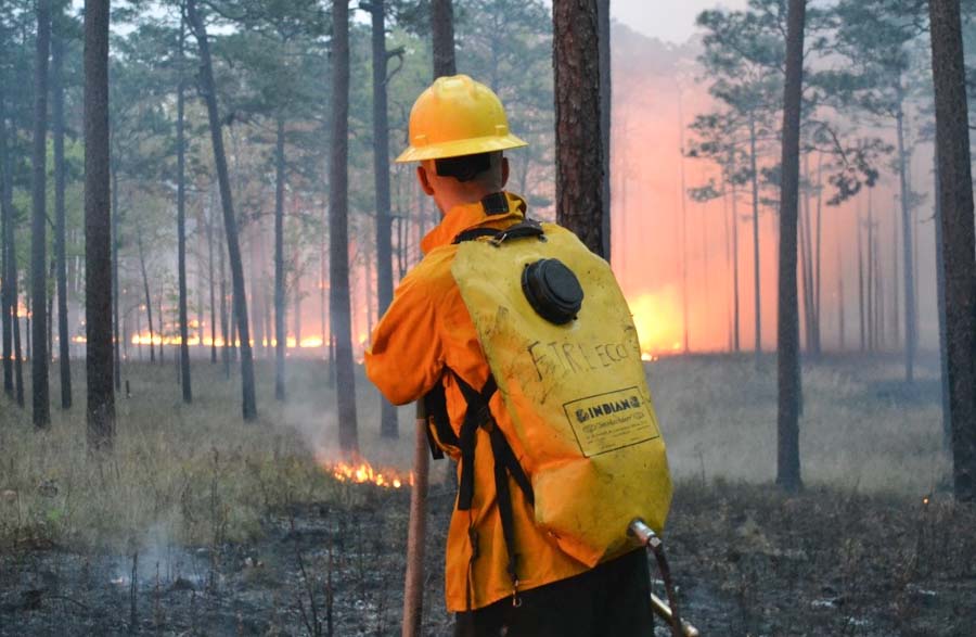
prescribed fire Florida
Austin Dixon of the Tall Timbers Research Station and Land Conservancy monitors a prescribed burn. Credit: Kevin Robertson

The majority of fires in Florida come in the form of prescribed burns, but because these fires are designed to be brief and contained, they often fall under the radar of satellites soaring overhead.

This is especially true in a state like Florida, where dense cloud cover is common and the warm, wet climate allows vegetation to regrow quickly after a blaze, disguising the scars that fires leave in their wake.

“Like a detective, satellites can catch a fire ‘in the act’ or from the ‘fingerprints’ they leave behind,” said study co-author Christopher Holmes, an assistant professor in EOAS. “In our area, catching an active fire in a thermal image can be hard because the prescribed fires are short, and we have frequent clouds that obscure the view from space.”

The state fire records also revealed a counterintuitive truth: Unlike in western states such as California, where dry conditions frequently produce massive increases in destructive and often uncontrollable fires, Florida actually experiences a decrease in land consumed by fire during drought.

When drought conditions emerge, researchers said, officials are less likely to authorize prescribed burns. And because prescribed burns account for the overwhelming majority of fires in the state, overall fire activity decreases.

This also suggests that prescribed burning programs — which aim to reduce the risk of wildfire in dry conditions — are having a materially positive effect.

“Although we still have occasional destructive wildfires, including the recent tragic Eastpoint fire, our results indicate that prescribed fire policy is helping to reduce wildfire risk,” Holmes said, referencing the June 2018 wildfire that destroyed dozens of homes in Florida’s Big Bend region.

Tall Timbers specialist Tracy Hmielowski uses a drip torch to ignite vegetation as part of a prescribed burn. Credit: Kevin Robertson
While the team’s study reconfirms the utility of prescribed burning, it calls into question prevailing estimates for airborne pollution from fire. If, as the study suggests, only 25 percent of fires in Florida are detected by satellites, then there could be “a rather large bias and a significant potential underestimation of emissions,” Nowell said.

The study’s findings are specific to Florida, but researchers suspect that similar satellite limitations may be skewing fire detection — and, consequently, emission estimates — in neighboring regions and geographically analogous areas like the savannas of Africa or the agricultural belts of Europe and Asia.

“We believe this result easily extends to the rest of the Southeast United States — which burns more area than the rest of the United States combined in a typical year — and other similar regions throughout the world that use small prescribed burns as a land management technique,” Nowell said.

Kevin Robertson, Casey Teske and Kevin Hiers from Tall Timbers contributed to this study. The research was funded by the National Aeronautics and Space Administration.

Thanks and a tip of the hat go out to Tom.
Typos or errors, report them HERE.

Wildfires close in on Utah communities south of Provo

The fires are threatening communities, including Woodland Hills and Elk Ridge

(UPDATED at 11:51 a.m. MDT September 16, 2018)

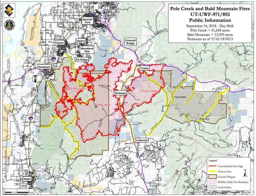
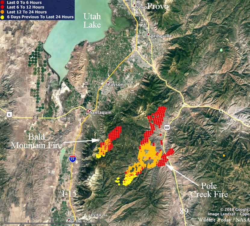
Map Pole Creek and Bald Mountain Fires
Map of the Pole Creek and Bald Mountain Fires with data from 12:16 a.m. MDT September 16, 2018. By the Incident Management Team.

The Incident Management Team reports that as of 12:16 a.m. Sunday the Pole Creek Fire had burned 61,248 acres and the Bald Mountain Fire, 13,509 acres.

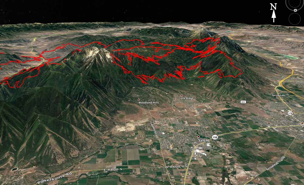
Map Pole Creek Bald Canyon Fires
3-D map of the Pole Creek and Bald Canyon Fires, looking south. Data from 12:13 a.m. MDT Sept. 16, 2018. Wildfire Today, Google, USFS. Click to enlarge.

(Originally published at 9:12 a.m. MDT September 15, 2018)

Smoke Pole Creek Bald Mountain Fires
Smoke from the Pole Creek and Bald Mountain Fires illuminated by flames. Posted on Twitter by Jennifer Stone (@stonejutah) with the hash tag #paysontemple

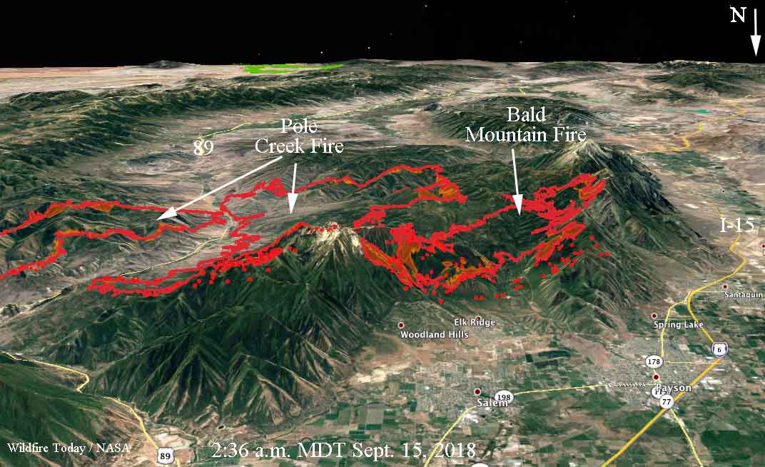
Fifteen miles south of Provo, Utah the Bald Mountain and Pole Creek fires had come within half a mile of merging when the fires were mapped at 2:36 a.m. Saturday. That city is not threatened but residents of Elk Ridge and Woodland Hills who have not evacuated yet are looking at flames on the steep slopes uncomfortably close to their homes.

Bald Mountain and Pole Creek Fires map
3-D map, looking south showing the Bald Mountain and Pole Creek Fires. The red lines were the perimeters at 10:45 p.m. MDT Sept. 14. The red dots represent heat detected by a satellite at 2:36 a.m. Sept. 15. The red shaded areas had intense heat Friday night. Click to enlarge.

The fires were started by lightning on the Unita National Forest — Pole Creek on September 6 and Bald Mountain on August 24. Initially Forest Service personnel allowed them to burn with the intention of suppressing only the portions that may threaten property, private land, important natural resources, or lives. They wanted to herd them around, while re-introducing a natural process, fire, into the environment.

To see all articles on Wildfire Today about the Pole Creek and Bald Mountain Fires, including the most current, click HERE.

Now they have both spread outside the land managed by the Forest Service and are burning private private property. No structures have been reported burned, but the estimated costs of suppressing the fires to date is almost $2 million. That number will keep rising as more firefighting resources flood in to augment the 433 personnel already on scene.

The reported sizes of the fires have been rather confusing at times, but according to a mapping flight at 10:45 Friday night the Pole Creek Fire was 48,497 acres and the Bald Mountain Fire had burned 11,090, for a combined total of 59,587 acres. A satellite overflight at 2:36 a.m. Saturday showed additional growth on the west and north sides that occurred in the four hours between the flights.

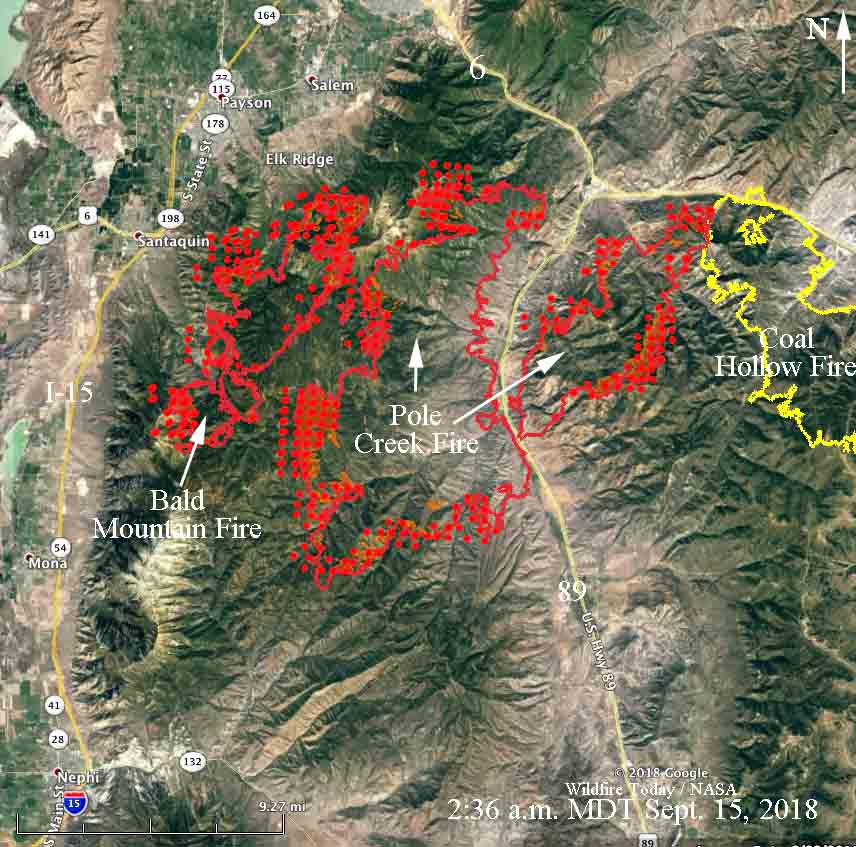
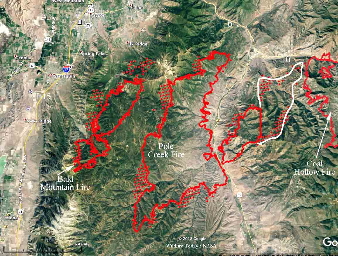
map Bald Mountain, Pole Creek, and Coal Hollow Fires
Map showing the Bald Mountain, Pole Creek, and Coal Hollow Fires. The red lines were the perimeters at 10:45 p.m. MDT Sept. 14. The red dots represent heat detected by a satellite at 2:36 a.m. Sept. 15. The red shaded areas had intense heat Friday night. The Coal Hollow Fire has been quiet for several days. Click to enlarge.

With a Red Flag Warning in effect through Sunday, rapid fire growth to the north and east is expected to continue, with strong winds, and on Saturday, single-digit relative humidity.

Red Flag Warnings
Red Flag Warnings in effect September 15, 2018.

Report released about firefighter fatality — trees were broken off during retardant drop

 Draper City, Utah Battalion Chief Matthew Burchett was killed when a low drop uprooted an 87-foot tall tree that fell on him

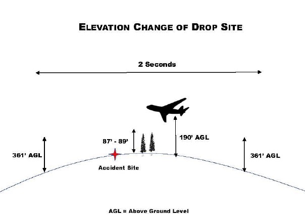
Diagram fatality air tanker drop Green Sheet
Diagram from the Green Sheet.

(Originally published on FireAviation, September 14, 2018. Updated at 7:43 MDT September 14, 2018)

The California Department of Forestry and Fire Protection (CAL FIRE) has released what they call a “Green Sheet” report about the fatality and injuries that were caused by falling tree debris resulting from an air tanker’s retardant drop. The accident occurred on the Ranch Fire which was part of the Mendocino Complex of Fires east of Ukiah, California. The report was uploaded to the Wildland Fire Lessons Learned Center on September 13, 2018 exactly one month after the August 13 accident.

A firefighter from Utah, Draper City Battalion Chief Matthew Burchett, was killed when a low drop uprooted an 87-foot tall tree that fell on him. Three other firefighters had different assortments of injuries from sheered-off trees and limbs, including broken ribs, deep muscle contusions, ligament damage to extremities, scratches, and abrasions.

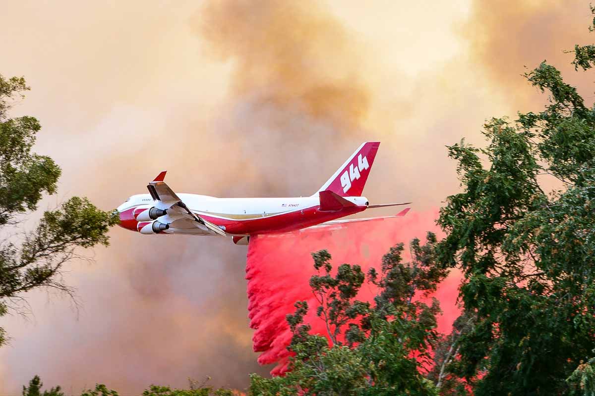
747 supertanker palmer fire
File photo: The 747 SuperTanker drops on the Palmer Fire south of Calimesa and Yucaipa in southern California, September 2, 2017. Photo by Cy Phenice, used with permission.

Standard procedure is for firefighters to leave an area before an air tanker drops. The report said the personnel on that Division were told twice that day to not be under drops — once in a morning Division break-out briefing, and again on the radio before the fatal drop and three others from large air tankers were made in the area. It was not confirmed that all supervisors heard the order on the radio to evacuate the drop area.

One of the “Incidental Issues / Lessons Learned” in the report mentioned that some firefighters like to record video of air tanker drops:

Fireline personnel have used their cell phones to video the aerial retardant drops. The focus on recording the retardant drops on video may distract firefighters. This activity may impair their ability to recognize the hazards and take appropriate evasive action possibly reducing or eliminating injuries.

The air tanker that made the drop was T-944, a 747-400 that can carry up to 19,200 gallons. Instead of a more conventional gravity-powered retardant delivery system, the aircraft has pressurized equipment that forces the retardant out of the tanks using compressed air. This is similar to the MAFFS air tankers. When a drop is made from the recommended height the retardant hits the ground as a mist, falling vertically, rather than the larger droplets you see with a gravity tank.

In this case, according to the report, the drop was made from approximately 100 feet above the tree tops. The report stated:

The Aerial Supervision Module (ASM) identified the drop path to the VLAT by use of a smoke trail. The VLAT initiated the retardant drop as identified by the smoke trail. Obscured by heavy vegetation and unknown to the VLAT pilot, a rise in elevation occurred along the flight path. This rise in elevation resulted in the retardant drop only being approximately 100 feet above the treetops at the accident site.

When a drop is made from a very low altitude with any air tanker, the retardant is still moving forward almost as fast as the aircraft, as seen in this drop. If it is still moving forward there will be “shadows” that are free of retardant on the back side of vegetation, reducing the effectiveness of the drop. From a proper height retardant will gradually slow from air resistance, move in an arc and ideally will be falling gently straight down before it hits the ground. Another example of a low drop was on the Liberty Fire in Southern California in 2017 that dislodged dozens of ceramic roofing tiles on a residence and blew out several windows allowing a great deal of retardant to enter the home.

We reached out with some questions to Global Supertanker, the company that operates the 747 Supertanker, and they gave us this statement:

We’re heartbroken for the families, friends and colleagues of Chief Burchett and the other brave firefighters who were injured during their recent work on the Mendocino Complex Fire. As proud members of the wildland firefighting community, we, too, have lost a brother.

On August 13, 2018, Global SuperTanker Services, LLC acted within procedural and operational parameters. The subject drop was initiated at the location requested by the Aerial Supervision Module (ASM) after Global SuperTanker Services, LLC was advised that the line was clear.

The former President and CEO of the company, Jim Wheeler, no longer works there as of September 1, 2018. The company is owned by Alterna Capital Partners LLC, of Wilton, Conn.

(Updated at 7:43 MDT September 14, 2018 to include the statement from Global Supertanker that we received at 7:35 p.m. MDT September 14, 2018)

Pole Creek and Bald Mountain Fires grow rapidly south of Provo, Utah

Above: Satellite photo taken at 6:12 MDT September 14, 2018, showing wildfires in Utah and Colorado 

(UPDATED at 7:32 p.m. MDT September 14, 2018)

The Pole Creek and Bald Mountain Fires continued to grow South of Provo Friday in Utah, but since the wind was not as strong they did not increase as much as in recent days.

The many different numbers we’re hearing for the sizes of the fires are confusing. Some of them conflate the two fires, Pole Creek and Bald Mountain, and some do not. Even when they are separated out, we are not convinced they are accurate. Having said that, Suzanne Tenhagen, a spokesperson for the Pole Creek Incident Management Team, told us at 7:05 p.m. Friday that the Pole Creek fire had burned 54,000 acres and the Bald Mountain, 14,500 acres.

To see all articles on Wildfire Today about the Pole Creek and Bald Mountain Fires, including the most current, click HERE.

The red dots on the map below represent heat detected by a satellite at 2:18 p.m. Sept. 14.

map coal hollow fire bald mountain pole creek utah wildfires
Map showing the Bald Mountain, Pole Creek, and Coal Hollow Fires. The red lines on the Bald Mountain and Pole Creek Fires were the perimeters at 11:30 p.m. MDT Sept. 13, 2018. The white line was the approximate additional growth that was missed during the 11:30 p.m. mapping. The red dots represent heat detected by a satellite at 2:18 p.m. Sept. 14. The Coal Hollow Fire has been relatively quiet for several days.

(Originally published at 9:55 a.m. MDT September 14, 2018)

Hot, dry, windy weather has caused two fires 15 miles south of Provo, Utah to increase in size dramatically over the last several days. The Pole Creek and Bald Mountain Fires initially started between Interstate 15 and Highway 89. On Thursday, pushed by a 12 mph southwest wind gusting to 25 mph with 6 percent relative humidity, the Pole Creek Fire reached Highway 89. It didn’t stop there, and kept going for another nine miles and may have reached the western edge of the 31,000-acre Coal Hollow Fire just south of Highway 6. The Coal Hollow Fire is nearly wrapped up and has been relatively quiet for several days.

The aircraft that mapped the Coal Hollow Fire at 11:30 p.m. MDT Wednesday came up with a size of 31,899 acres. However, a large portion of the fire east of Highway 89 was not mapped. Our very unofficial, rough estimate of the unmapped area is that it covers approximately 7,000 acres, based on heat detected by a satellite at 2:53 a.m. MDT September 14. This would bring the total to more than 38,000 acres. The fire is 17 miles long, measured southwest to northeast.

The Bald Mountain Fire, west of Pole Creek, did not grow as much on Thursday. It was mapped Wednesday night at approximately 6,600 acres. Both fires were very active during the satellite overflight at 2:53 a.m.

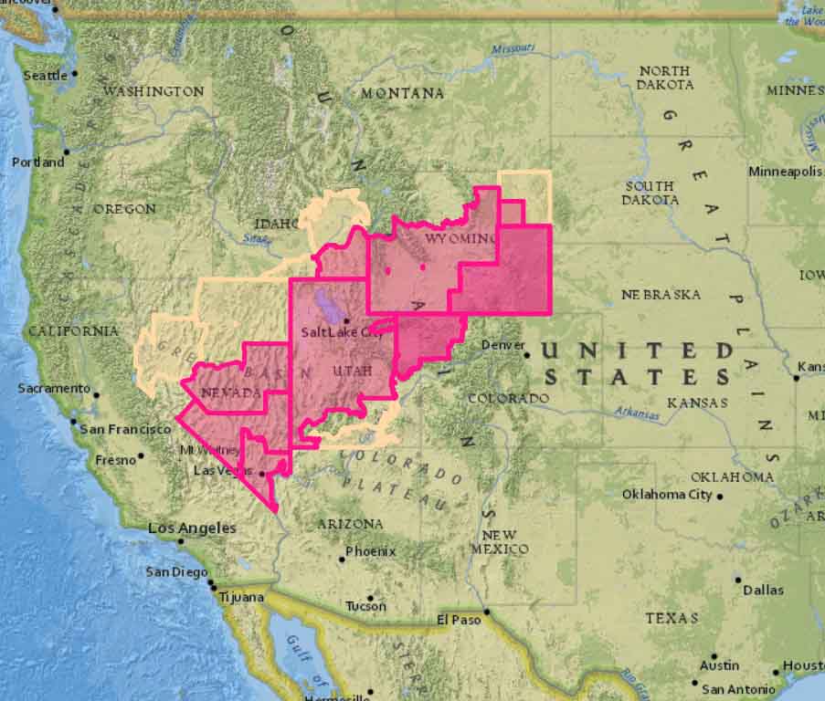
Utah and several other states have been under Red Flag Warnings for days, and that should continue through Saturday. Friday’s forecast for the fire area calls for a high of 89, relative humidity extremely low at 6 percent, and 15 to 18 mph southwest winds gusting to 25. These conditions will be conducive to continued spread to the northeast, with the possibility of reaching or even crossing Highway 6.

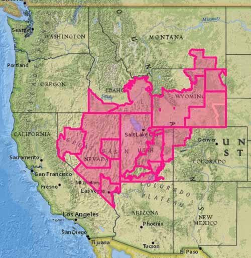
Red Flag Warnings
Red Flag Warnings (red) and Fire Weather Watches (yellow) for September 14, 2018. NOAA

Fire activity picks up in Utah and Colorado

At least five large wildfires are growing in the two states

Above: Satellite photo at 5:37 p.m. MDT Sept. 13, 2018 showing smoke from wildfires in Utah and Colorado.

(Originally published at 7:16 p.m. MDT September 13, 2108)

The Red Flag Warning that brought strong winds and very low humidities Wednesday and Thursday contributed to the rapid growth of several wildfires in Utah and Colorado.

In Utah two fires about 18 miles south of Provo spread very rapidly Wednesday night and Thursday. The Pole Creek and Bald Mountain Fires, between Highways 54 and 89, are only about five miles apart. Two Type 1 Incident Management Teams are en route to these fires.  Todd Pechota’s team will manage the Bald Mountain Fire and Beth Lund’s team will take the Pole Creek Fire.

To see all articles on Wildfire Today about the Pole Creek and Bald Mountain Fires, including the most current, click HERE.

Map Pole Creek Bald Mountain Fires
Map of the Pole Creek and Bald Mountain Fires showing heat detected by a satellite as late as 2:36 p.m. MDT September 13, 2018.

At 2:36 p.m. MDT a satellite detected heat on the Pole fire indicating that it had spread over a relatively narrow path 14 miles long and had crossed Highway 89. This information from a satellite 200 miles overhead is preliminary and needs to be confirmed by someone closer to the ground.

The Bald Mountain Fire appeared to have spread about five miles. Both fires were pushed by strong southwest winds, causing them to grow to the northeast.

Our extremely rough very unofficial estimate of the size of the two fires in Utah, based on the 2:36 p.m. MDT satellite data on Friday — at that time the Bald Mountain Fire had burned approximately 2,000 acres and the Pole Creek Fire had grown to about 14,000 acres.

Two fires along Highway 318 in northwest Colorado 10 and 24 miles northwest of Maybell were quite active Thursday. They are named the Three Wash and Boone Gulch Fires.

The Silver Creek Fire 16 miles northwest of Kremmling, Colorado continued to spread toward Highway 40. Thursday afternoon it was about three miles west of the highway.

Everyone Goes Home in the Wildland program is introduced

Above: WFF Executive Director Vicki Minor and NFFF Executive Director Ron Siarnicki. Screenshot from the video referenced below.

The National Fallen Firefighters Foundation (NFFF) is announcing a new initiative directed toward wildland firefighters. Today with the support of the Wildland Firefighter Foundation (WFF), they are introducing the Everyone Goes Home in the Wildland program. It is an offshoot of the Everyone Goes Home® (EGH) program established by the NFFF in 2004 featuring the 16 Firefighter Life Safety Initiatives. Their goal was to “help the U.S. Fire Administration achieve its objective of reducing the number of preventable firefighter fatalities”.

In 2017 the NFFF began a series of six listening sessions around the United States asking firefighting personnel for their ideas about how to reduce line of duty deaths and injuries on wildland fires. Input was also obtained from natural resource management organizations that have not traditionally identified themselves as part of what we know collectively as “the fire service.”

Drawing from their success in reducing LODDs among structural firefighters through programs under the Everyone Goes Home® umbrella, the NFFF now proposes to leverage their strengths and resources to do the same for wildland firefighters.

The actions taken today include the release of a video in which WFF Executive Director Vicki Minor and NFFF Executive Director Ron Siarnicki discuss their collaboration and adoption of the 16 Firefighter Life Safety Initiatives in the wildland environment.

In addition, a 12-page report is available that summarizes the findings of the NFFF’s wildland firefighting needs assessment, including the surveys and listening sessions. This paper will be the guiding document for this effort, prioritizing EGH program development for wildland firefighters in the near future.

Today the WFF and NFFF also released a tri-fold brochure designed to introduce the concepts of the 16 Firefighter Life Safety Initiatives to the wildland firefighter. It is designed to be downloaded and printed by organizations, either professionally or on a standard copier.