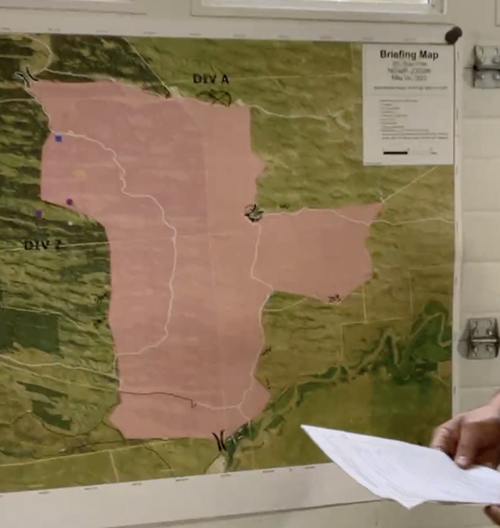
Map of the 201 East Fire, Friday morning, May 20, 2022.
In a Friday morning briefing Caleb, Operations Section Chief, said the 201 East Fire in Central Nebraska is still 4,100 acres and is not expected to grow larger.
Updated 9:09 p.m. MDT May 19, 2022
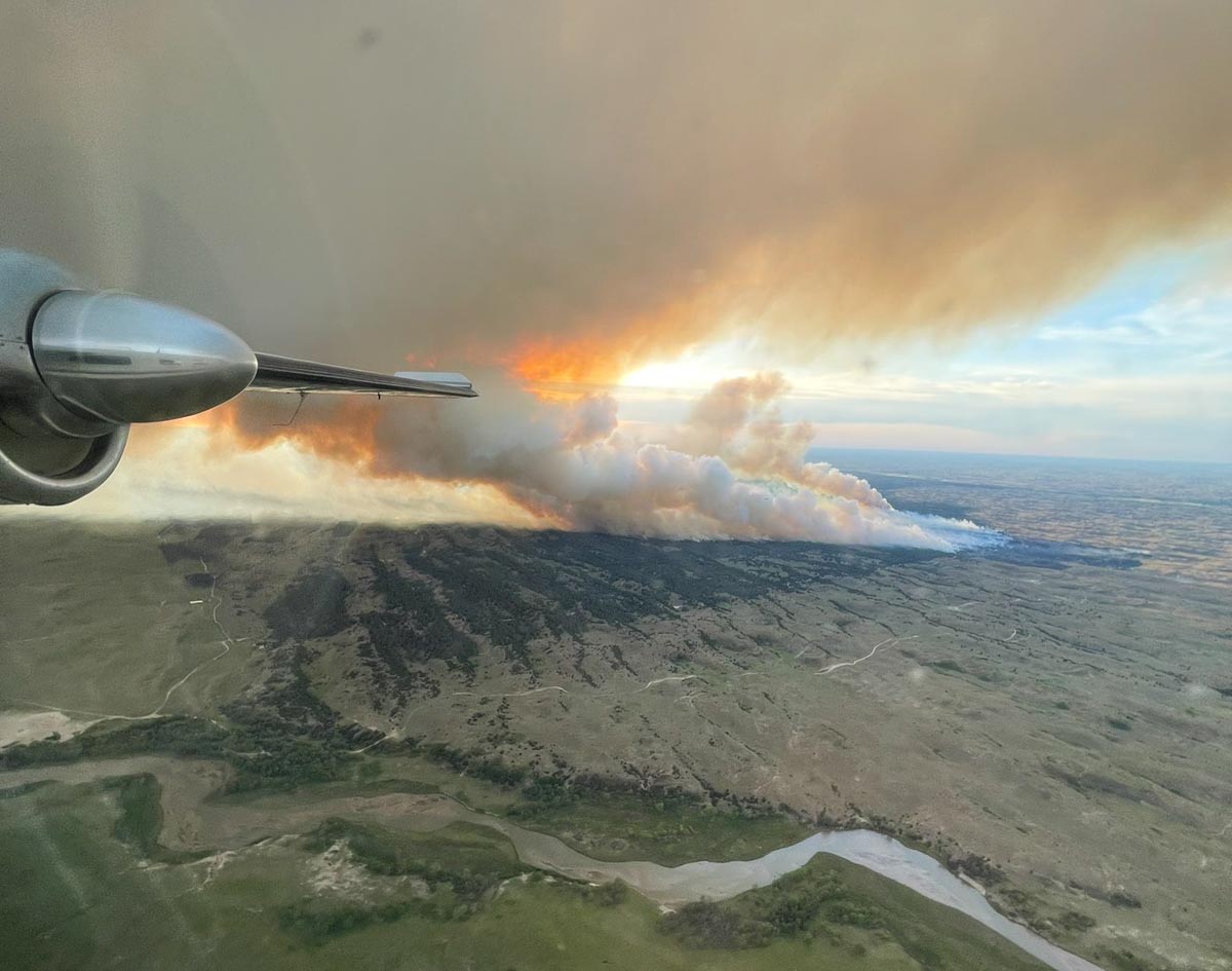
201 East Fire in central Nebraska, May 19, 2022. By@littleemilee6.
The 201 East Fire in Central Nebraska was very active again Thursday afternoon, as the convection column topped out with a hint of pyrocumulus. Thursday evening fire officials estimated it had grown to 4,100 acres, an increase of about 2,600 acres since Wednesday evening. Much of the growth was on the east side where it ran for about two miles, but when the wind shifted from coming from the west and then north gusting to 30 to 35 mph, it spread to the south where it merged with the Whitetail Fire, which also started from Tuesday’s lightning; it had been stopped at 8 acres, but flared up again Thursday. As of Thursday evening, the additional southward spread had not crossed the Dismal River.
Firefighters were battling 90 degree temperatures and strong, shifting winds.
Additional firefighting resources are arriving, including hand crews, helicopters, and engines. They hoping to directly suppress the flanks as it moves into the grass to the east.
The forecast for Friday is cooler temperatures, 55 degrees, 40 percent relative humidity, and 18 mph winds gusting out of the northwest at 28 mph, but there is a 26 percent chance of rain Friday night.
201 East Fire in central Nebraska, May 19, 2022. By@littleemilee6.
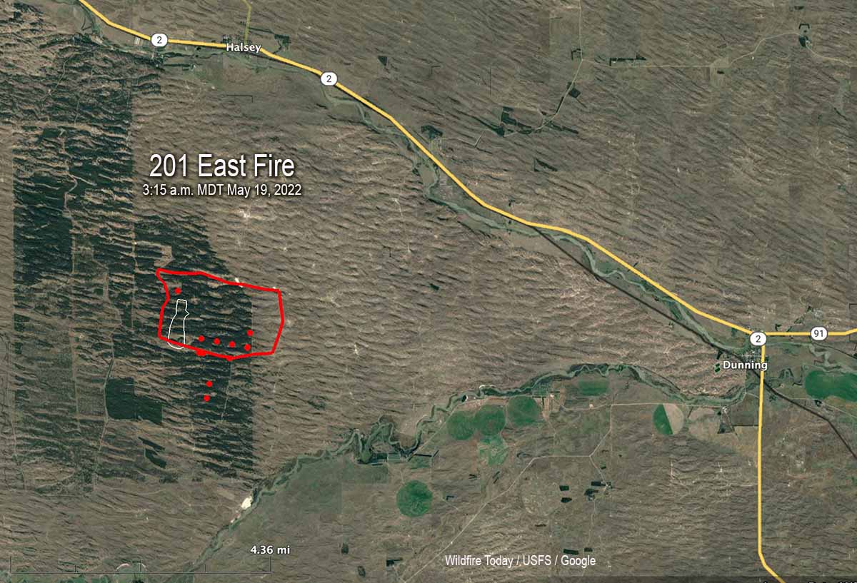
9:48 a.m. MDT May 19, 2022
Map of the 201 East Fire in Nebraska. The red line was the approximate perimeter early in the morning May 19, 2022. The white line was the perimeter about 24 hours before. The red dots represent heat detected by a satellite at 3:15 a.m. MDT May 19, 2022.
A fire in central Nebraska has burned about 1,500 acres of timber in the Nebraska National Forest. The 201 East Fire is one of six in the area ignited by lightning on Tuesday May 17. Firefighters were able to stop the spread of the others at less than 9 acres.
It started in a 21,000-acre patch of timber three miles south of Halsey. By Wednesday morning a dozer line had it mostly encircled, but in the afternoon the fire crossed the line on the east side and ran for about 1.5 miles, leaving the timber and getting into grass. District Ranger Julie Bain said greenup has started but there is enough dead grass mixed with this year’s growth to still carry a fire, but they feel they can more easily stop it in the grass.
201 East Fire in Nebraska, May 18, 2022. Photo by Air Attack pilot @littleemilee6.
Aircraft used on the fire Wednesday included two single engine air tankers, two large air tankers, and an air attack ship. A Type 3 incident management team has been assigned.
The weather recorded at Thedford Wednesday afternoon as the fire made the run to the east was 6 to 13 mph winds occasionally gusting to 17 mph, 84 degrees, and 26 percent relative humidity.
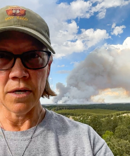
USFS District Ranger Julie Bain at a lookout tower during a briefing about the 201 East Fire, Wednesday afternoon May 18, 2022.
Numerous large wildfires are burning in New Mexico
Smoke forecast for 5 p.m. MDT May 18. NOAA.
Smoke from wildfires in New Mexico is drifting into the Southeast United States. While much of the smoke is not at ground level except in East New Mexico and West Texas, the impact should at a minimum produce red sunsets for a couple of days across the Southern states.
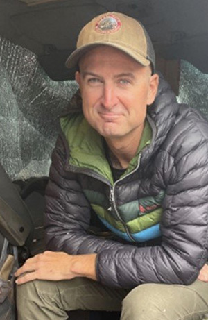
Patrick Gladics was working as a Helicopter Manager in Sierra Vista
Patrick Gladics. BLM photo.
A Bureau of Land Management firefighter who was reported missing on May 14 was found deceased May 16 in Sierra Vista, Arizona.
Patrick Gladics was staying at a hotel while working out of the Sierra Vista Municipal Airport in southern Arizona as a helicopter manager, but failed to report to duty on May 14.
The Coronado National Forest reported that the Sierra Vista Police Department with the assistance of Arizona Department of Public Safety Air Rescue, found the body of the 38-year-old firefighter shortly before 12:30 p.m. May 16.
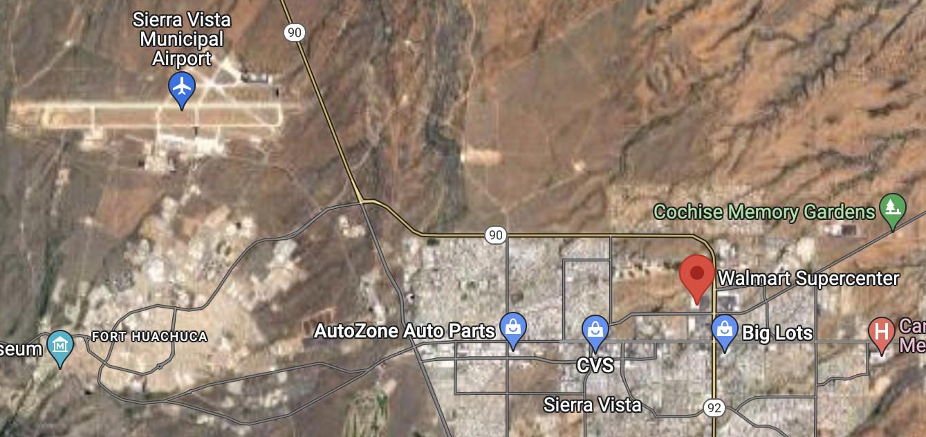
Mr. Gladics was found deceased in the desert area west of Walmart in Sierra Vista. SVPD Special Operations detectives responded to investigate the scene. The case is being referred to the Pima County Medical Examiner’s Office for further investigation.
His BLM vehicle had been located at the Walmart in Sierra Vista on Monday. Video surveillance showed him on foot heading north toward the open desert from the parking lot at about 5 a.m. on Saturday May 14.
The 11,620-acre San Rafael Fire is near the US/Mexico border 20 miles southwest of Sierra Vista. The latest entry on Inciweb was on May 15, reporting that the fire was 100 percent contained and was staffed by five people. Another fire in the area, the 112-acre Locklin Fire 20 miles southeast of Sierra Vista, was listed as contained April 30.
We send out our sincere condolences to the family, friends, and coworkers of Mr. Gladics.
Red Flag Warning for the Calf Canyon / Hermits Peak Fire, May 19-20, 2022. NWS.
The National Weather Service has taken the unusual step of issuing a Red Flag Warning one and two days in advance for the Calf Canyon / Hermits Peak Fire 21 miles east of Santa Fe, New Mexico. The prediction is for winds gusting from the west and southwest at more than 30 mph with single digit relative humidity. Similar conditions will exist at least on Thursday for the area of the Black and Bear Trap Fires in southwest New Mexico.
Updated 12:10 p.m. MDT May 18, 2022
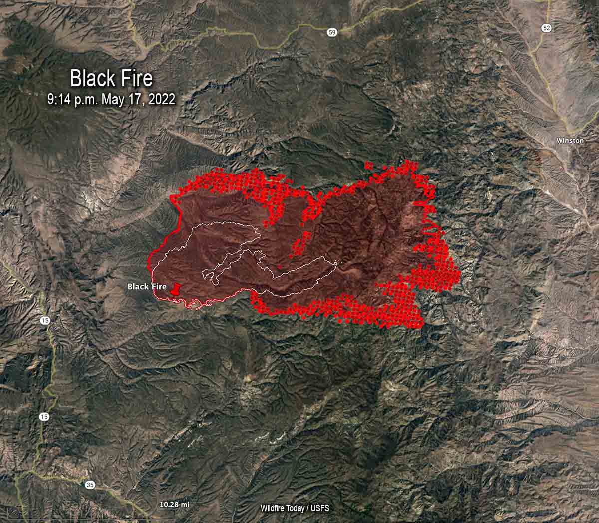
Map of the Black Fire. The bright red dots represent heat detected by a satellite at 2:48 a.m. May 18. The red line is the perimeter at 9:14 p.m. May 17. The white line is the perimeter about 48 hours before.
On Wednesday the northern half of New Mexico is under a Red Flag Warning. Isolated dry thunderstorms are predicted for portions of New Mexico, Texas, and Colorado.
Red Flag Warnings Wednesday.
Chance for isolated dry thunderstorms in portions of NM, CO, & TX.
From the NWS:
“Thunderstorms are expected across portions of the central Rockies this afternoon. Storms should be dry with the potential for new lightning induced fire starts.” pic.twitter.com/kT4KwlJC27
The Calf Canyon – Hermits Peak Fire 21 miles east of Santa Fe, NM was active on the west side Tuesday, but there was very little significant activity on the east side between Mora and Las Vegas.
The Cerro Pelado Fire 25 miles west of Santa Fe was relatively quiet Tuesday. There has been no major spread for several days and a satellite was only able to detect one large heat source early Wednesday morning.
Black Fire, May 16, 2022. IMT photo.
The Black Fire (see map above) 28 miles west-northwest of Truth or Consequences made another large run to the east Tuesday adding another 21,000 acres to bring the total up to 77,360. Fuel treatments and wildfires that have occurred over the last 20 years may slow any major spread to the north, west, and south, but the NIFC database shows no significant history of fire east of the incident.
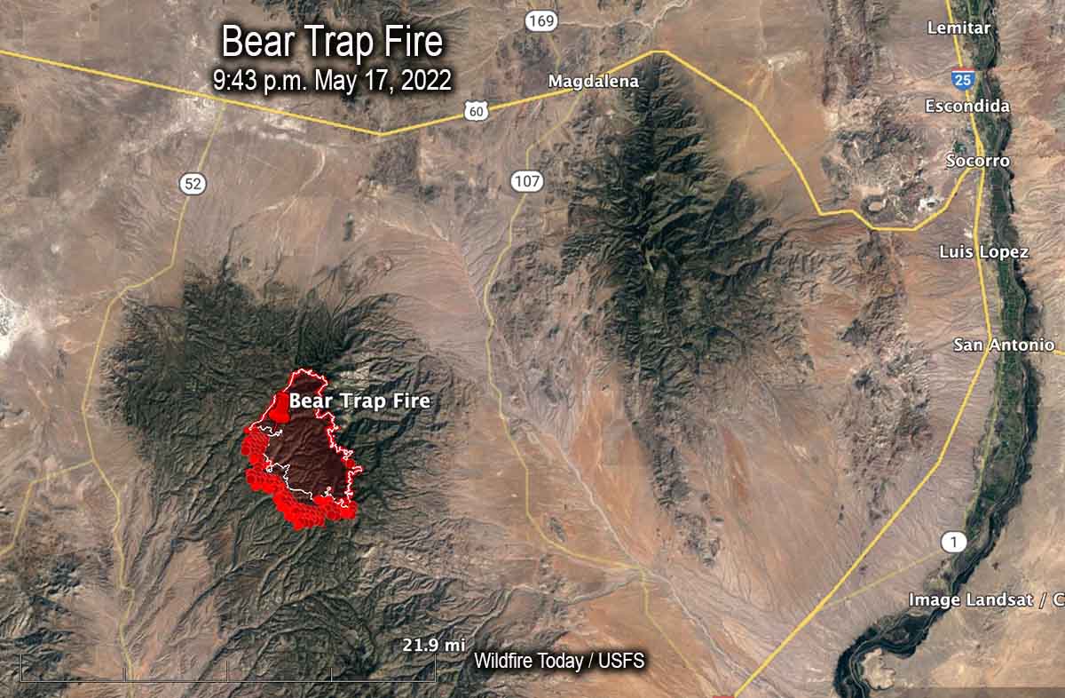
Map of the Bear Trap Fire. The bright red dots represent heat detected by a satellite at 2:48 a.m. May 18. The red line is the perimeter at 9:43 p.m. May 17. The white line is the perimeter about 24 hours before.
Another fire in southwest New Mexico, the Bear Trap Fire, is 34 miles southwest of Socorro. It spread southwest on Tuesday and was mapped Tuesday night at 15,215 acres. The fire is surrounded by fuel treatments and prescribed natural fires on all sides except for the southwest — which is where the most of the spread has occurred during the last couple of days.
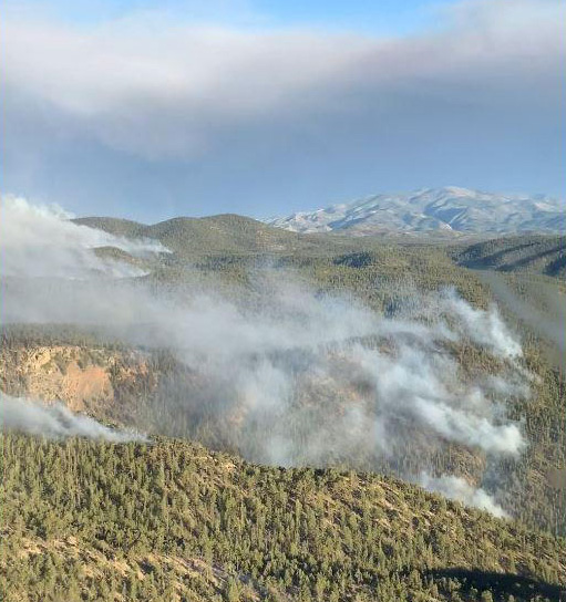
South side of the Bear Trap Fire, May 16. IMT photo.
5:10 p.m. MDT May 17, 2022
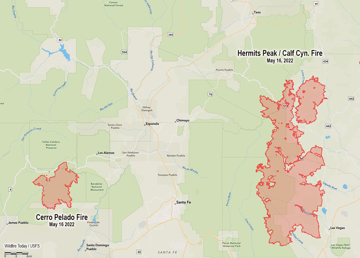
Map showing the location of the Cerro Pelado and Calf Canyon – Hermits Peak Fires, the evening of May 16, 2022.
High temperatures and very low humidity on Tuesday kept most of the large wildfires in New Mexico very active.
Calf Canyon – Hermits Peak Fire
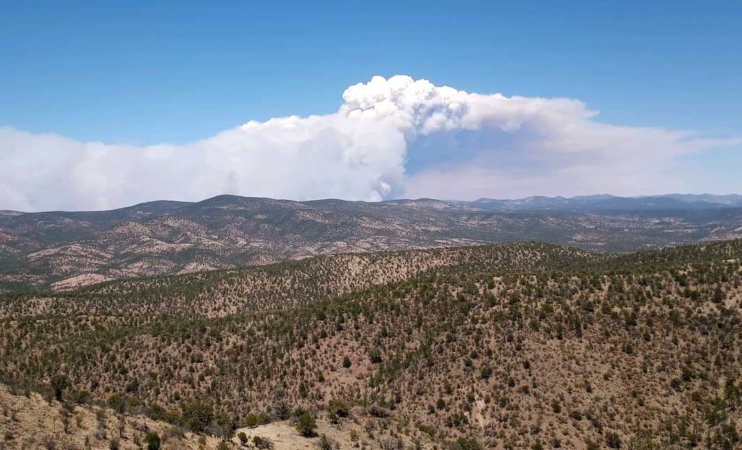
The Calf Canyon – Hermits Peak Fire 21 miles east of Santa Fe has become the largest fire in the recorded history of New Mexico. At 299,565 acres it has eclipsed the previous record set by the 297,845-acre Whitewater and Baldy Fires when they burned together in May of 2012 in Southwest New Mexico. On Tuesday it was again putting up a large smoke column while a 5 to 20 mph wind gusted out of of the northwest, west, and southwest at 25 mph. The humidity dropped to 10 percent in the afternoon.
Cerro Pelado Fire
On Monday most of the fire activity on the 45,605-acre Cerro Pelado Fire was on the northwest and southeast sides. On Tuesday the fire 25 miles west of Santa Fe was putting up much less smoke than the Calf Canyon – Hermits Peak Fire, judging from the Satellite photo below taken at 3:56 p.m.
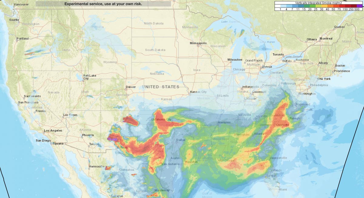
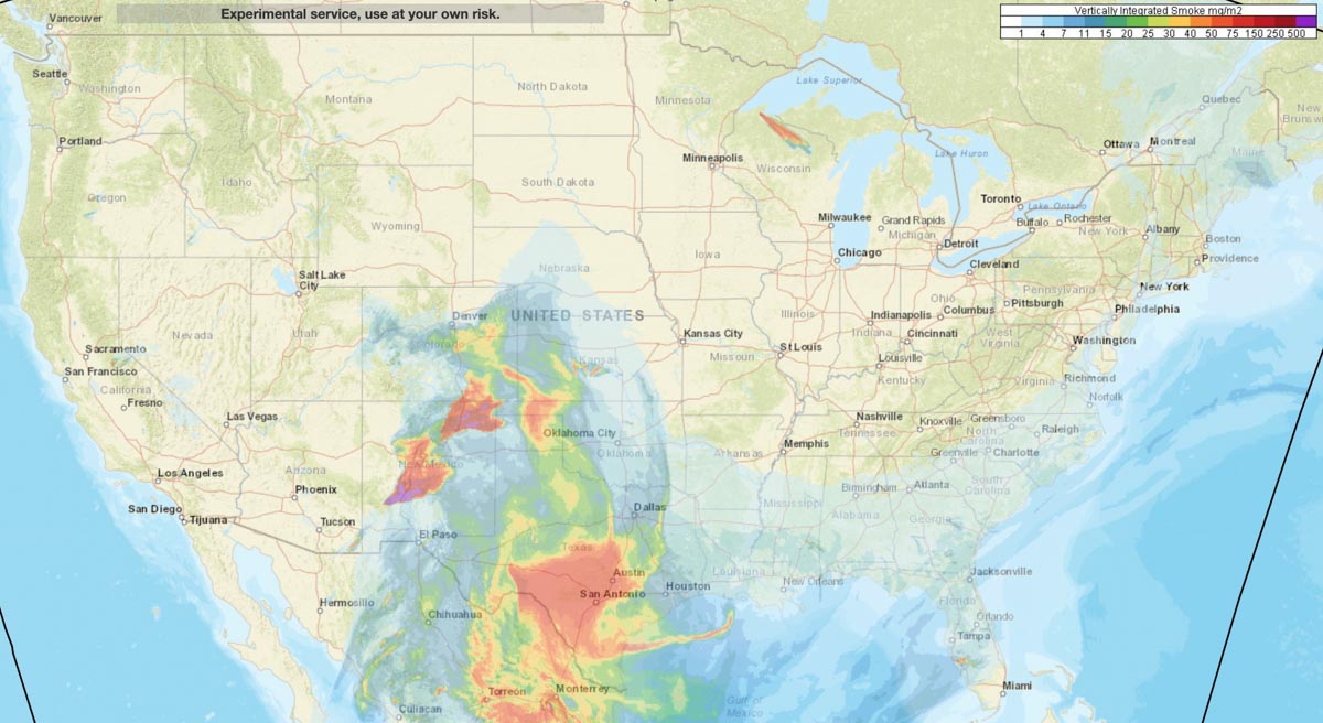
Vertically integrated wildfire smoke at 5 p.m. MDT May 16, 2022.
Large quantities of smoke from the Black and Calf Canyon Fires in New Mexico is impacting other states, including Texas, Oklahoma, Colorado, and Kansas.
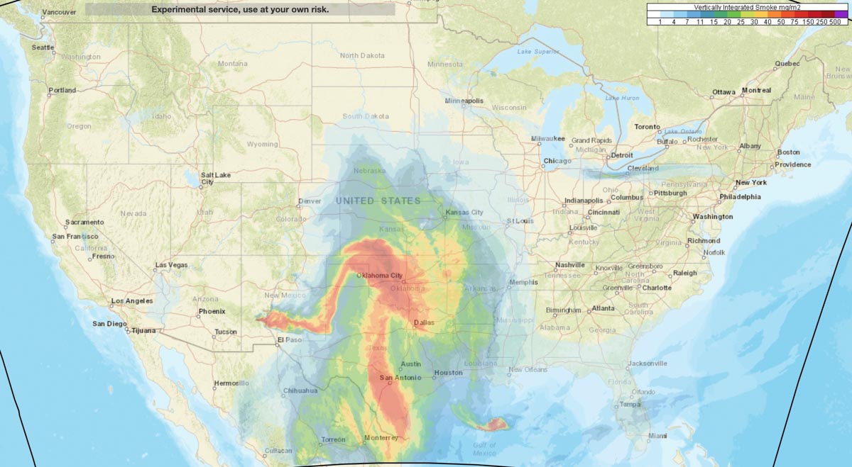
Vertically integrated wildfire smoke forecast for 10 a.m. MDT May 17, 2022.
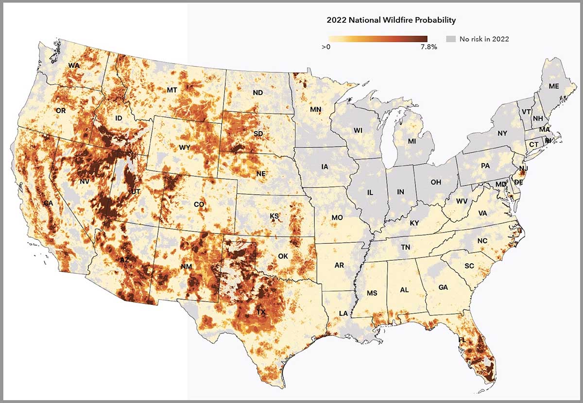
National Wildfire Probability. First Street Foundation. 2022.
An organization has developed a system for calculating the wildfire risk of 145 million properties this year and 30 years from now.
The First Street Foundation’s Risk Factor is a free source of probabilistic wildfire risk information where anyone can enter a street address and within seconds see the risk for both wildfires and floods at that location.
We tested the system by entering property addresses for two locations that were severely impacted by recent wildfires.
The Marshall Fire near Boulder, Colorado last year destroyed 1,091 homes and damaged 179. We looked up the Risk Factor for three properties in a community that had total destruction. The result was that they all had a 3 of 10 “moderate fire factor”, and individually a 1.84, 2.0, 1.84 percent chance of being in a wildfire over the next 30 years.
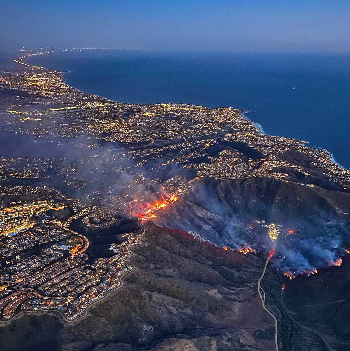
The Coastal Fire(see photo below) destroyed 20 homes last week in Laguna Niguel, California and damaged 11. The two we looked at in the zone with severe destruction received a 3 of 10 “moderate fire factor” with a 0.93 and 1.54 percent chance of being in a wildfire over the next 30 years. The homes were at the top of a steep brush-covered slope.
Coastal Fire, Orange County, CA, May 11, 2022. ABC7.
The text below is how the First Street Foundation describes their rating system for wildfire risk:
There has long been an urgent need for accurate, property-level, publicly available environmental risk information in the United States based on open source, peer reviewed science. In a mission to fill that need, First Street Foundation has built a team of leading modelers, researchers, and data scientists to develop the first comprehensive, publicly available risk models in the United States. Beginning with flood and now wildfire, First Street works to correct the asymmetry of information in the market, empowering Americans to protect their most valuable asset–their home while working with industry and government entities to inform them of their risk.
METHODOLOGICAL OVERVIEW
The First Street Foundation Wildfire Model integrates information on fuels, wildfire weather, and ignition into a Fire Behavior Model. The wildfire model requires data on the combustible fuels which may contribute to wildfire across the United States. The 2016 update, Version 2.0.0, of the canonical U.S. Forest Service (USFS) LANDFIRE (LANDFIRE, 2021) fuels dataset at the 30 meter resolution serves as a baseline of this fuels estimate, and that dataset is updated by including additional information of all known “disturbances” between 2016 and 2020 which could modify or change the fuels in a way not captured in the original dataset. These “disturbances” include activities such as recent wildfires, prescribed burns, harvests, and other forest management practices.
Another important and novel update included in the First Street Foundation Wildfire model is the reclassification of homes and other buildings from a “nonburnable” fuel type to a “burnable” fuel type. Typically, homes and other buildings are classified as nonburnable fuel types within LANDFIRE v2.0.0. In order to allow the wildfire behavior model to more accurately estimate how wildfire moves through the Wildland-Urban-Interface (WUI), properties within the WUI must be replaced by a burnable fuel type so as to not block the modeled wildfire spread.
To represent a wide range of possible weather-driven wildfire conditions across the landscape within the simulations employed here, the model utilizes a decade of NOAA weather data, the 2011-2020 Real Time Mesoscale Analysis (RTMA) dataset (NOAA/NCEP, 2022) augmented by data from Oregon State’s PRISM dataset (Parameter-elevation Regressions on Independent Slopes Model; PRISM, 2021).
These weather data include hourly surface wind, air temperature, relative humidity, and precipitation information at the 2.5 km horizontal resolution. This weather data supports a wide range of possible weather conditions, not to recreate any particular wildfire events, but to drive the wildfire behavior model millions of times in a Monte Carlo simulation scheme to derive 2022 wildfire hazard estimates.
Similarly, for 2052 the same weather time series was used to drive the simulations, but the air temperature, humidity, and precipitation were bias-adjusted to 2052 conditions following the CMIP5 RCP4.5 ensemble results. Rather than applying a bias-adjustment to the wind time series for the future climate, the same winds from the 2011-2020 time series were used to drive the 2052 simulations to reduce sensitivity of the model to highly uncertain future predictions of winds.
One of the primary indicators of where future wildfires will occur is informed through data on historical wildfire occurrences. These historical wildfires help to inform where wildfires may occur vis-à-vis the Fire Occurrence Database (FOD) developed by the USDA Forest Service (Short, 2014; Short, 2021). An open source wildfire behavior model was used, ELMFIRE (Eulerian Level Set Model of Fire Spread). This work does not develop new techniques for wildfire modeling, but rather implements computationally efficient and scalable modeling techniques at a high resolution based on existing science, wildfire probability, and hazard modeling paradigms. These scalable techniques make it practical to more easily conduct wildfire simulations at the 30 meter resolution across the entire country, enabling property and building specific assessments of wildfire risk.
For each 30 meter pixel across the country, information is recorded on the distribution and occurrence of burn incidence, flame lengths experienced, and the relative amount of embers which land in the pixel. These provide estimates of:
Burn probability: the estimated likelihood of the area burning during any single year.
–Fire intensity: estimated flame lengths, including maximum, average, and sum of all flame lengths experienced.
–Ember exposure: the relative amount of embers which land in an area due to nearby simulated wildfires.