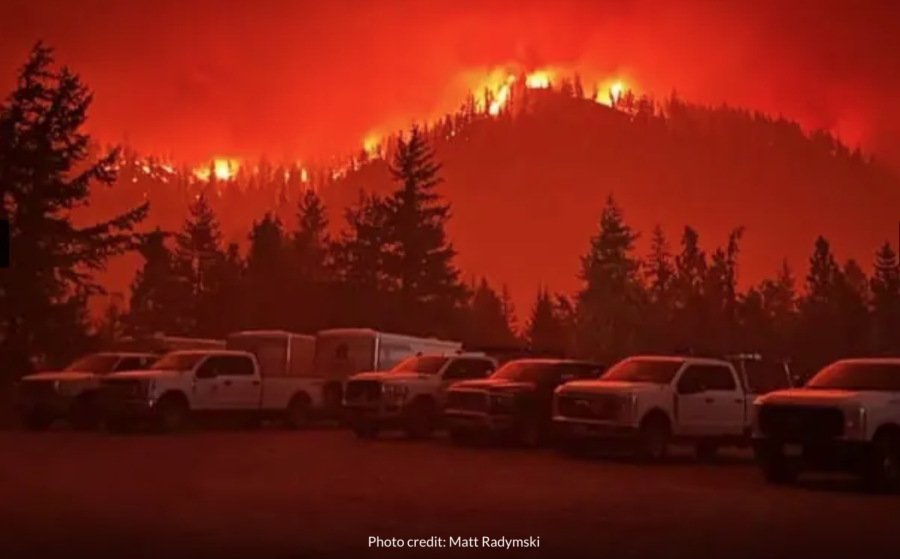
There’s only one way in and out of the Canadian municipality of Whistler.
The Coast Mountains surround the forested British Columbia town north of Vancouver, giving Whistler its world-renowned trait of being North America’s largest ski resort community. The rocky slopes, however, occasionally cause transportation problems for Whistler’s residents. Highway 99, the only passage through the southern parts of the mountain range, stands as residents’ only escape route during times of emergency.
Whistler firefighters reflect on the 2023 wildfire season
The frequently suffocated roadway and recent devastating wildfires in the nearby communities of West Kelowna and Kelowna pushed the perennially snow-focused municipality to begin serious planning for a potential fire disaster. Most Whistler neighborhoods are classified as “interface,” but the wildland and ornamental fuel load between residences have characteristics of an “intermix,” or homes being within a forest community. Because of this, Whistler scores high in the plan’s “overall fire risk” category.
Whistler’s pervasive forest primarily drove town officials to take a more proactive approach to wildfire defense in its creation of a community wildfire defense plan.
Whistler firefighters reflect on the 2023 wildfire season
“Typically when a wildfire is approaching a community, these defense plans are done at the time as it’s approaching,” Whistler Fire Chief Thomas Doherty told Global News journalists for a recent article. “Obviously wildfire specialists will come in and assist with doing these neighborhood defense plans. We’ve done that in advance. We believe we’re one of the first municipalities to do this type of plan, to have this information readily available ahead of time.”
Whistler firefighters reflect on the 2023 wildfire season
The approach Doherty references includes increasing FireSmart education for residents and visitors, changing municipal legislation and community planning with a wildfire resiliency focus, increasing interagency and firefighters’ wildfire response, and continuing strategic vegetation management efforts.
Global News, in their conversation with Doherty, reports that one of the tools created from this plan includes 19 tactical sheets and GIS maps for various critical infrastructure and water source locations, identifying which neighborhoods have a one-way-in and one-way-out access, and safe zones for responders during times of emergency. All this information will reportedly be available to fire personnel through scannable QR codes.
“Extremely critical to have all this information done in advance,” Doherty said. “It’s just unfortunate when an event does occur. At least we’re that much more prepared. And we have all that information readily available.”
You can read the full Whistler Community Wildfire Defense Plan [HERE].
The Coast Mountains surround the forested British Columbia town north of Vancouver, giving Whistler its world-renowned trait of being North America’s largest ski resort community. The rocky slopes, however, occasionally cause transportation problems for Whistler’s residents. Highway 99, the only passage through the southern parts of the mountain range, stands as residents’ only escape route during times of emergency.
A fire-focused NPR article had a concise central theme: Trees are not always good, fire is not always bad, and prescribed burning can bring a community together.
The article, written and beautifully photographed in 2022 by journalist Andria Hautamaki, told the story of the Loess Canyon Rangeland Alliance to paint a larger picture of the quick growth prescribed burn associations (PBAs) have had across the country, particularly in states without huge extents of government-owned land.
The Great Plains Fire Science Exchange estimated in 2022 that there were 113 PBAs throughout the United States. That exchange now estimates 135 PBAs, an 83 percent increase in under two years.
Plants flourish after a prescribed fire. Image courtesy Florida Panther National Wildlife Refuge.
PBAs got their start in California and are now found throughout the state. Despite this, California is an outlier in the average states with PBAs: nearly half of California’s land is federally owned. Other states with numerous PBAs (including Nebraska, Oklahoma, and Texas) have less than 2 percent of their land owned by the federal government.
Instead of the USFS burning on federal land, stakeholders in non-West states must convince and collaborate with landowners to spread the gospel of prescribed fire.
“The only way you’re ever going to get fire on the ground is through the landowners, especially in states with a lot of private land,” John Weir, an Oklahoma State University extension specialist for prescribed fire, told Hautamaki during the story. “This is landowner helping landowner. Agencies are important; they help provide technical assistance. But it’s all about grassroots. Landowners can burn safely and effectively because they’re out there managing their own land.”
An abundance of privately owned land isn’t the only thing driving PBA popularity in non-West states. The negative perception fire has gained from numerous disastrous wildfires in recent years has hampered Rx burn efforts in the West. Midwest and Southern states, which don’t have that same negative association with burning, have seen a rise in a grassroots-led fire efforts rather than an agency push.
Previous data have also shown the community-prescribed fire drive to be safe and effective in overcoming common burn limitations related to expertise, equipment, and personnel. A 2012 survey of PBAs found the majority were effective at developing burn plans, working within burn windows, and limiting liability.
“The safety record of PBAs indicates they provide a safe and viable option for landowners and managers who use or would like to use prescribed fire on their lands,” the survey said.
In the northwest portion of Lake Superior is a chunk of land of about 132,000 acres that is both a geographic novelty and an International Biosphere Reserve. The Isle Royale National Park is 56 miles off Michigan’s shore and 18 miles from Minnesota’s mainland. Congress designated the 50-mile-long island as a national park in 1931, but even before that it was apparent the island’s boreal forests had a close history with fire.
“Official fire record keeping began in 1847, when the first General Land Office survey of Isle Royale was conducted,” according to the park’s website. “These records show 31 fires between 1847 and 1898. Data suggests fire was more frequent and/or severe in the boreal forest of the island’s northeast end, compared with the northern hardwoods of the southwest end.”
The island’s dense concentration of high-flammability trees, e.g. balsam fir, black spruce, and jack pine, heightened the risk of wildfires igniting when lightning struck. A zoologist in 1931 recognized the important role fire played in the island’s unique ecosystem, but his ideas were discarded in favor of the system-wide preference toward fire suppression.
Flammable species on Isle Royale
“In planning for improvements and facilities on Isle Royale, the National Park Service consulted with University of Michigan Zoologist Adolph Murie,” the park said. “Murie visited Isle Royale in June 1935 and recommended that no new trails be cleared by the CCC and all efforts be made to ‘guard against any sort of development which will reduce space or increase travel.’ He also recommended that forest fires be allowed to occur on Isle Royale, but this idea was rejected, and instead, an aggressive anti-forest-fire point of view was adopted.”
Officials would soon come to regret dismissing Murie’s ideas. Park historians describe the summer of 1936 as hot and dry. Hundreds of CCC enrollees arrived at the heavily logged and mined island to establish the park. On July 25, a fire started near the Consolidated Paper Company and, while a cause was never determined, the “Fire of 1936” would have the most profound effect on the natural and human history of Isle Royale compared with any other historical event.
Around 200 CCC members and loggers tried in vain to fight the fire as it grew from 200 to 5,000 acres over 10 days. The fire was reported as contained on August 4, but two spot fires that had ignited on August 2 would become much larger problems. By August 18, the three fires burned 27,000 acres before they were officially declared out after heavy rainfall.
Multiple factors contributed to the high number of acres burned in the fire, park historians said. The island’s ground was, at the time, mostly covered in highly flammable mosses. In-fighting between the park system and CCC members, including a short CCC strike when tobacco supplies ran out, likely made matters worse.
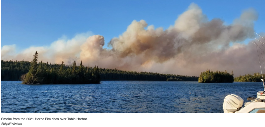
The island wouldn’t see significant wildfires again until the 2021 Horne Fire and the 2022 Mount Franklin Fire, which burned 335 acres and 6 acres respectively. In the fires’ wake, scientists and researchers hope to use the burned areas to learn more about the dynamics between fire and the island’s life.
“The area may look different, but wildfire is an agent of necessary change,” the park said. “At the site of the Horne Fire, Isle Royale ecologists now have a living laboratory, and these researchers can begin to study the relationships between fire, living things, and an island environment.”
Stories about the land the park exists on, located at the convergence of the Great Plains, Great Basin, and Columbia Plateau, were originally seen as tall tales because they were too fantastical to be true, according to park nonprofit Yellowstone Forever. Eventually, however, formal expeditions verified that the land was indeed covered in multicolored hot springs and spouting geysers, paving the way for the area’s federal protection and park designation.
The people who originally pushed Congress to protect the area were crafting their own tall tale, unbeknownst to themselves. The park’s first leaders told Congress that the park could be protected and run without any funding from the federal government. That idea was soon disproven.
Yellowstone’s first superintendent, Nathaniel Langford, was unpaid, and he and others quickly saw how the lack of funding made protecting the park’s wildlife and natural resources extremely difficult.
Essex County Herald, Vermont. September 02, 1920
Langford’s first annual park report to the federal government was filled with stories of squatters, poachers, and vandals creating problems throughout the area.
“A few months before … creating the park, several persons had located upon land at some of the points of greatest interest, with a view to establish squatter’s right of preemption,” Langford’s report said. “The reality of the land should be held alone by the Government, and be subject to such rules and regulations as may, from time to time, be adopted by the Department of the Interior.”
Langford’s report also marked a step toward the first national park’s first fire policy.
“It is especially recommended that a law be passed, punishing, by fine and imprisonment, all persons who leave any fire they may have made, for convenience or otherwise, unextinguished,” the report said. “Nothing less than a stringent law punishing negligence and carelessness can save the extensive pine timber fields of the park from destruction.”
The policy would soon become a reality not just for the park but for the nation as a whole. U.S. law mandates that anyone who starts a fire on federal lands and doesn’t extinguish it could face imprisonment for up to six months (on USFS lands) and no more than 12 months if on BLM lands.
It’s been four years since a near-perfect storm hit the U.S. West. COVID-19 was officially declared a pandemic by the World Health Organization in March 2020, just months before the worst wildfire season in recorded history.
The interactions between wildfire and COVID-19 were large and sweeping, research in the years since has shown. The 2020 season left lasting impacts on the wildland firefighting force, both systemically and personally.
Wildland firefighters are at high risk for both COVID-19 infection and, when infected, experiencing severe illness from the virus, research published in the National Library of Medicine and Science academic journals found. Researchers in one study examined potential health and workforce capacity impacts by modeling the movement of suppression resources across the country over a season and the corresponding potential for disease spread and cascading outbreaks across wildfire incidents.
The increased risk stems primarily from firefighters’ exposure to wildfire smoke, limited access to hygiene supplies, and constantly being physically near other wildland firefighters and the public.
IHC superintendents were surveyed by USFS researchers a year after the fires burned. At the beginning of the pandemic, the agency launched a wide range of new practices for hotshot crews to limit the spread of COVID-19 while also, it was hoped, improving operational efficiency. New practices included changes in pre-fire preparation, using virtual paperwork and briefings, and reformatting traditional fire camps to a more widespread layout. The USFS also created a COVID-19 Incident Risk Assessment Tool for fire managers; it measured numerous factors including camp size, mitigation techniques, and number of positive cases to estimate how at-risk each crew was.
The researchers wanted to know if superintendents were interested in maintaining any of those practices in daily hotshot crew use in the years after 2020, regardless of COVID-19. The survey found that the majority of practices contributed positively to operational efficiency in addition to crewmember safety and well-being. Most respondents preferred the ease of virtual vs. in-person paperwork and briefings, they liked having crews spike on or near the line with the full-scale ICP camp away from the fire, and they felt better physically and mentally as a result of these changes.
Wildland firefighter well-being — and proper pay — are still a major focus for the USFS post-2020 as retention becomes an increasingly worrying issue. Research conducted this year on retention found that highly skilled wildland firefighters with a high number of assigned days, payment of additional annual earnings, and gained experience throughout the firefighter’s career all had positive effects on retention. Local wages of alternative occupations in a firefighter’s local area had no significant effect on retention.
The future of wildland firefighter physical health may also see improvements thanks to technological developments stemming from COVID-19. Respiratory illnesses like coronavirus, and other long-term health risks firefighters face such as lung cancer and cardiovascular disease, may be seen in firefighters less and less as mobile respirators proceed further in development.
California fitted wildland firefighters with a mobile respirator prototype last October while they dug firelines or cut down trees with chainsaws. The results were mixed.
“Plenty broke. Hoses popped out of sockets. Straps snapped. Masks slid down sweating faces. Filters became dislodged,” Julie Johnson wrote for the San Francisco Chronicle.
During this event, firefighters from Cal Fire, L.A. County and the USFS took turns trying out several types of mask. They hiked down a slope and then back up, then pulled off their masks, sweating and breathing hard in triple-digit temps. Each round took only about ten minutes.
Firefighters shared their impressions with observers: Felt like a muzzle. Was too bulky. Too tight. It slipped off my face once I began to sweat.
Hearing one of her colleagues say “it’s better than nothing,” Cal Fire’s Sol Espinoza spoke up. “I’d rather take nothing,” she said.
The test is one of many completed or planned throughout the country as the fire agencies look to lower firefighter mortality from diseases increasingly found to be worsened through wildfire smoke inhalation. Experts have hedged their bets on technology frequently used to keep COVID-19 patients hospitalized with severe cases alive. Adaptations in the technology are still under development as researchers figure out which version might be best suited to meet the dynamic needs of firefighters in the field.
Espinoza, a firefighter with Cal Fire in San Bernardino. Espinoza said she could never imagine wearing a constrictive device that makes it harder to breathe.
The “beating heart of the American wine industry” has had to reckon with this question since 2017 when numerous wildfires spread across northern California’s famed wine country. The Tubbs, Atlas, and Nuns fires burned hundreds of thousands of acres, caused numerous deaths, and destroyed multiple wineries and vineyards in Napa and Sonoma counties.
The total acreage burned and widespread property damage caused the 2017 wildfire season to be the most destructive in California’s history. That record-breaking year was quickly surpassed by the 2018 and 2020 fire seasons. The 2020 season, in particular, also broke burn records in the other top American wine-producing states of Oregon and Washington, and even Canada in 2021. Wildfires in the years following impacted international wine markets as well, including Italy, France, and Australia.
Intense flames aren’t the only threat wildfires bring to vineyards; it’s also the smoke they produce. A condition called “smoke taint” causes wine grapes exposed to smoke to acquire “unmarketable smoky, burnt, ashy, or medicinal sensory characteristics,” according to the Australian Wine Research Institute (AWRI).
Agriculture-based technological developments, however, can only do so much to keep a fire-sensitive crop alive after it’s planted on fire-dependent lands. Grapes, while not technically invasive, have invaded portions of the Western United States’ lands and have largely usurped once highly forested regions where fire played an important ecological role. As prescribed fire establishes a larger role in modern Western land management practices, how long can an industry based on fruit that needs a smokeless environment survive and thrive?
What’s not well-recorded is how agricultural land conversions cleared millions of acres of conifer and oak forests throughout the state to make way for vineyards and other crop fields. In Napa and Sonoma counties specifically, areas now known as the pinnacle of “wine country,” modern vineyards sit on land that once supported massive oak forests culturally maintained by the area’s various Indigenous tribes.
“While almost all of the valley oaks are gone from Napa — the savannas were largely cleared to make way for intensive agriculture in the late 19th century — a few pockets remain,” a New York Times article on the Napa Valley Historical Ecology Atlas said. “The oldest trees, dating back more than 300 years, were alive when the Caymus, Napa, Canijolmano and Mayacma tribes managed the valley to produce abundant acorns, deer, salmon, and other staples.”
The clearing of these woodlands was coupled with a government-mandated suppression of cultural burning, a kind of prescribed burning Native Americans used to promote culturally significant foods and resources within a landscape. After a century of fire suppression, the USFS has begun to understand how significant cultural fire is to promoting biodiversity and creating healthy landscapes.
“Colonization and subsequent governmental fire policy mandates have disrupted the cultural use of fire, which in turn has disrupted ecological functions where those fires are absent,” USFS research said. “As society grapples with the devastating impacts of wildfires and the loss of biological diversity, many Indigenous people see traditional fire use as a key to mitigation of devastating losses while retaining traditional livelihoods associated with burning.”
In hopes of preventing future megafires, California increases prescribed burns throughout the state, including wine country. Even though research shows smoke from prescribed burns tends to be less harmful and toxic compared with smoke from wildfires, the grapes themselves don’t seem to care.
“Studies have shown that grapes need to be exposed to only a single smoke event, irrespective of the source, to become ‘tainted,’” AWRI said. “Bushfires, forest fires, planned burns, grassfires, and agricultural burns can all cause smoke taint if smoke from those fires is present in a vineyard at a high enough level for a period of time. Current research suggests fresh smoke presents the greatest risk for smoke taint, but smoke that has drifted hundreds of kilometers has also resulted in smoke taint.”
Efforts have been made for fire planners and wine producers to work together to minimize smoke’s negative effects on wine grapes, but thus far have mostly been in vain. AWRI and other wine industry researchers recommend the best time to conduct prescribed burns to limit smoke taint is during the height of wildfire season between May and October; before grapevine flowering and after grape harvest. The “usual” best times to set prescribed burns, mid-spring or in the fall, are the most at-risk times for smoke taint in grapes.
The contradiction is clear: Grapes, at least those that winemakers don’t want smoke-tainted, can’t exist in an area with regularly prescribed burns, e.g. California.
Grapes themselves are partly to blame for this. A concept called “terroir” has been used for centuries to describe the deep ecology behind why grapes grown in different places and in different ways acquire different qualities. Everything including temperature, soil, geology, elevation, water quality, wind direction, farming practices, and the winemaking process influences grapes and, by extension, the wine made from them. Even if researchers could 100 percent prevent smoke-taint issues in wine grapes, the grapes themselves would still be affected by the inevitable changes the fire-dependent landscape will experience in years to come.
The irony is that California does have native grapes, which thrived in the state’s pre-colonized and fire-dependent forests. In fact, the global wine industry wouldn’t exist today without California Wild Grapevines, as the species was used to save the European wine industry between 1870 and 1900 when most wine grapes were killed by leaf- and root-attacking aphids. Winemakers, in a last-resort desperate bid, used Califonia Wild Grapevine roots and grafted them onto European grape varieties. The result was a plant with the root resilience of a wild grape and the desirable taste of a European grape.
California wild grapes themselves, however, were originally discredited by European colonists for being too “foxy” and not containing enough sugar. But in a state destined to have more smoke, the more fire-resilient California Wild Grape, whose burnt vines can resprout, may soon be the California wine industry’s only option. One farmer in Sonoma County agrees and is experimenting with more than 30 different native grape hybrids in response to climate change.
The global wine industry is one of stubborn tradition. The industry’s desire to find easy “solutions” to existential problems without systemic change paints a worrying picture of the role California’s vineyards play in the state’s fight against future wildfires. Winemakers can only hide behind the industry’s $70 billion price tag for so long.
There comes a point at which economic benefit is outweighed by potential ecological destruction, and the industry will soon have to decide whether it will play a role in California’s solutions to megafires or actively hamper efforts to help make the state’s landscape healthy. Winemakers in California may soon have to answer the question of “when should this industry die?”


 Global News, in their conversation with Doherty, reports that one of the tools created from this plan includes 19 tactical sheets and GIS maps for various critical infrastructure and water source locations, identifying which neighborhoods have a one-way-in and one-way-out access, and safe zones for responders during times of emergency. All this information will reportedly be available to fire personnel through scannable QR codes.


 The island wouldn’t see significant wildfires again until the
  This month marks


