Report released on entrapment of six firefighters on the Cedar Fire in Arizona

cedar fire entrapment

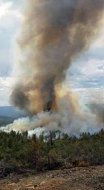
Above: Fire whirl on the Cedar Fire, June 28, 2016, around the time of the entrapment. Screen grab from the video.

A report has been released on the entrapment of six firefighters that occurred on the Cedar Fire south of Show Low, Arizona June 28, 2016.

The firefighters were part of the Navajo Interagency Hotshot Crew (NIHC) that remained along with two Type 6 engines and possibly one other crew after the Type 1 Incident Management Team was released the previous day. The assignment of half the crew, nine firefighters, was to “monitor” a part of the southwest side of the fire that had six miles of uncontained fire edge. The other half was working on the southeast side.

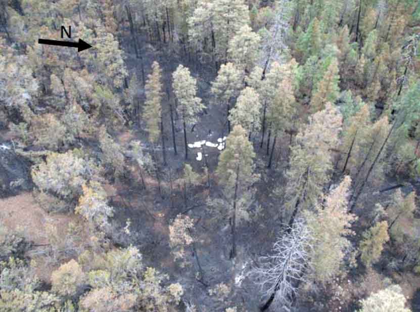
Three of the nine personnel on the southwest side served as lookouts while the remaining six were monitoring and checking the fire edge. When a very large fire whirl developed near the six, they realized their escape route was cut off, and took refuge in a previously burned area. The ground fuels had burned, but the canopy was still intact. As the fire approached they deployed their fire shelters, remaining in them for about 30 minutes.
cedar fire entrapment site
The entrapment site at the Cedar Fire.

After the fire whirl subsided, the squad members were able to hike out to staged vehicles. They were transported in three ambulances, medically evaluated, and transported to Summit Hospital in Show Low, Arizona where they were evaluated. Two firefighters were treated for smoke inhalation and all were released by 10 p.m. that evening.

The report says the personnel deployed and entered the shelters just as they had practiced several times in training, and the devices worked as designed. There were no difficulties, as reported at other entrapments, with the PVC bags becoming soft and difficult to open.

Thankfully there were no serious injuries and the training the firefighters had received paid off.

But there are a number of interesting facts about what occurred before the entrapment

Resources on the fire

On June 27, the day before the entrapment, the Type 1 Incident Management Team issued their final update on the 45,977-acre fire just before they were released later that day. Below is a portion of the document.

cedar fire update

The report claims the Type 1 Team recommended that the number of personnel assigned be reduced on Tuesday June 28 to about 400. But on Monday, June 27 all firefighters except for two Type 6 engines were released. With a 70 percent chance of rain in the weather forecast, on Tuesday the local agency decided to replace the Type 1 Team with a Type 4 Incident Commander, two Type 6 engines, and one or two hand crews. The crew(s) had to be re-mobilized on Tuesday after being released. Some aircraft were also assigned on Tuesday.

Video of the large fire whirl

Weather on Tuesday, the day of entrapment

About 20 minutes before the 2:45 p.m. entrapment the weather at the fire was 95 degrees, 21 percent relative humidity, with a 7 to 10 mph wind out of the south. Although “numerous” people observed dust devils and fire whirls before the large fire whirl formed, there was no discussion about modifying fire suppression tactics. Dust devils can be an indicator of the potential for extreme fire behavior.
cedar fire entrapment
Fire whirl on the Cedar Fire, June 28, 2016. Screen grab from the video.

Report on the use of night-flying helicopters on the Cedar Fire

The Wildland Fire Lessons Learned Center has released a report on the use of night-flying aircraft on the Cedar Fire west of Kernville, California that burned approximately 30,000 acres in August.

Two night-flying helicopters, from the Angeles National Forest and Kern County, were used along with a night-flying air attack. The video above shows the two helicopters flying to and dropping on a spot fire detected by the air attack ship.

Below are some quotes from the report:

“We were the first resources into the subdivision. We were having a difficult time figuring out where to go (fire front). Night ATGS located us with infrared and directed us to the right location.”
Engine Captain

“The Helicopter saved our bacon and let us keep working on digging line.”
Crew Member

“We were digging line next to the fire. I looked up and there were 25-foot flames. H-531 came in, cooled it down, and we continued digging line.”
Crew Member

Be-200 scooping air tankers reportedly effective working in Portugal

Be-200ES
File photo of a Be-200ES rolling out of the factory.

A Russian news service is reporting that the two Be-200 Russian-made amphibious scooping air tankers have been effective in Portugal. Quoting the Russian Emergencies Ministry, Sputnik News wrote:

“Overall, two Emergencies Ministry aircraft carried out 37 discharges of water, the total mass of which amounted to 444 tonnes, tackling fire in four spots and saving four settlements and two national parks,” the statement reads.

And:

“The Russian Emergencies Ministry’s airgroup, consisting of two Be-200ES aircraft, continues to work on extinguishing large forest fires in Portugal. On August 15, [Russian pilots] extinguished two fires covering a total area of 500 hectares [over 1,200 acres],” the statement reads.

It is possible the effectiveness of the aircraft is exaggerated. Air tankers do not “extinguish” fires. Under ideal conditions they can slow them down, allowing firefighters on the ground to move in closer and put them out.

Damage assessment teams report 96 homes destroyed in the Blue Cut Fire

(UPDATED at 9:39 a.m. PDT August 20, 2016)

There was very little growth of the Blue Cut Fire on Friday. As on Thursday, the east side of the fire was fairly quiet, while there is still fire activity on the west side, especially east and southeast of Wrightwood.

The incident management team is calling it 37,020 acres. On Saturday morning they revised upward the estimate of the number of structures destroyed, to 105 homes and 213 minor structures. Some evacuations are still in place.

****

(UPDATED at 4:15 p.m. PDT August 19, 2016)

CAL FIRE Public Information Officer Daniel Berlant reported this afternoon that Damage Assessment Teams estimate that 96 homes and 213 outbuildings have been destroyed in the Blue Cut Fire.

The fire has burned approximately 39,000 acres north of San Bernardino, California, according to the incident management team.

****

(UPDATED at 7:55 a.m. PDT August 19, 2016)

Blue Cut Fire
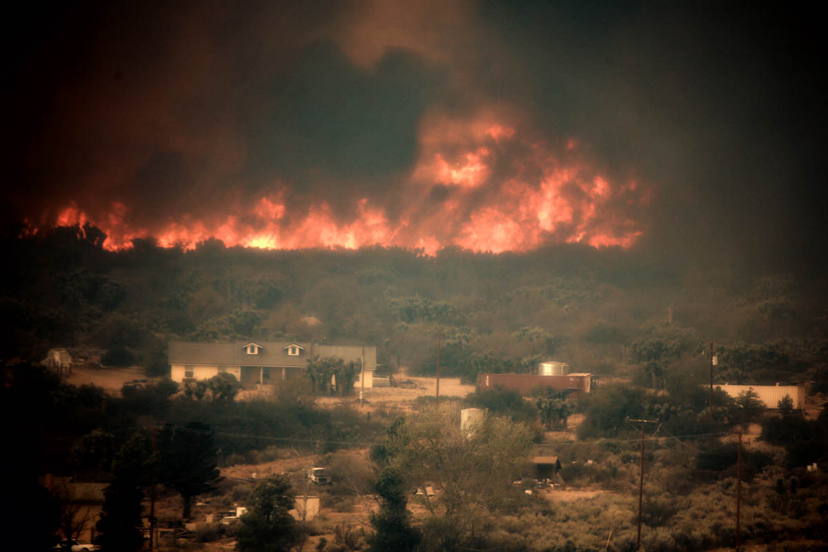
Blue Cut Fire. Photo by Jeff Zimmerman.

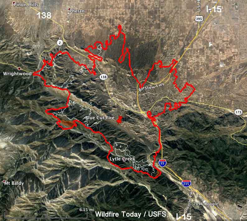
On Thursday the spread of the Blue Cut Fire north of San Bernardino in southern California was limited to the west side. According to the incident management team led by incident Commander Rocky Opliger, the growth added about 5,300 acres, bringing the total up to 39,000 acres.

The expansion occurred:

  • on the north side in the flats southeast of Phelan,
  • east of Wrightwood near Highway 2,
  • in the remote mountainous area on the west side, and
  • near Lytle Creek on the south side of the fire.

The east side of the fire has been relatively quiet for a couple of days.

Map Blue Cut Fire
Map of the Blue Cut Fire. The red line was the perimeter at 10:30 p.m. PDT August 18, 2016. The white line was the perimeter approximately 24 hours before.

A Red Flag Warning is in effect for the fire area Friday until 9 p.m. this evening for 15 to 25 mph southwest to west winds gusting to 35 mph during the afternoon and evening. Relative humidities will be 10 to 15 percent.

The fire started August 16 and grew to tens of thousands of acres quickly. Numerous structures were seen burning on live television, but no information has been released about how many were affected.

The incident management team expects the fire will continue to move to the north, northwest and northeast towards Wrightwood, Victor Valley, Phelan, Baldy Mesa and South Hesperia. Evacuations are still in place.

****

(UPDATED at 7:43 a.m. PDT August 18, 2016)

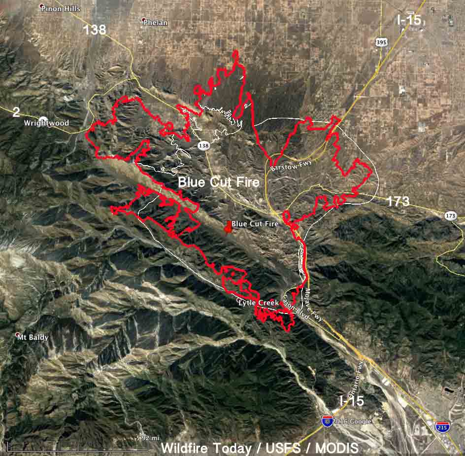
Map Blue Cut
Map of the Blue Cut Fire. The red line was the perimeter at 8 p.m. PDT August 17, 2016. The white line was the estimated perimeter approximately 24 hours before.

The Blue Cut Fire northwest of San Bernardino continued to spread Wednesday. The additional growth was on the northwest side where it reached Highway 2. And, on the north side it expanded a small amount at the base of the mountains and in the high desert flats toward Phelan. Evacuations are still in effect.

More accurate mapping on Wednesday resulted in the incident management team reducing the mapped size from 30,000 to 25,626 acres. After the growth of the fire yesterday, this morning they are calling it 31,689 acres.

Northbound Interstate 15 has reopened, but the southbound lanes are still closed. CALTRANS information about road conditions. UPDATE at 11:42 a.m. PDT August 18, 2016: Southbound I-15 is now open also.

Continue reading

Report released on burnover of CAL FIRE engine

The California Department of Forestry and Fire Protection has released what they call a “Green Sheet”, a summary of the burnover of an engine that occurred as it was making a mobile attack on the Pacheco Fire, which eventually burned 341 acres in Calaveras County south of Valley Springs.

****

“SUMMARY

On July 12, 2016, a CAL FIRE Type 3 Model 34 engine (E1) attempted to start a mobile attack toward the head of a vegetation fire. Firefighters deployed two lines, but before they could anchor and start the mobile attack, the main fire and several spot fires converged on the fire engine. One firefighter took refuge in the engine, and one firefighter ran into the green. The engine sustained damage from the fire. Neither firefighter was injured.

CONDITIONS

  • Weather: 89°, 21% relative humidity, winds 9 mph from the west and shifting, taken from the Campo Seco RAWS at 1400 hours.
  • Fuel Type: Approximately two feet tall grass.
  • Topography: Southeast aspect, rolling topography with multiple draws
  • Fire Behavior: Sheeting, fire whirls, spotting

SEQUENCE OF EVENTS

On July 12, 2016, at approximately 1314 hours, CAL FIRE and local government resources were dispatched to a vegetation fire in the vicinity of Langford Pacheco Road and Milton Road in Calaveras County. The initial report on conditions given by the Air Attack at 1329 hours was 15 acres of grass woodland and spotting out in front of the main fire. At 1356 hours, the fire was reported to be 100 acres in size and spotting under the column.

A CAL FIRE engine (E1) arrived at scene at 1345 hours and was assigned Division R, the right flank of the fire. The crew met with a Battalion Chief (BC1) and came up with a plan to create an anchor point and start a mobile attack toward the head of the fire. A second CAL FIRE Engine (E2) and Dozer (D1) were just behind E1.

As E1 crossed through a gate to make access to the fire. E1 stopped in the green and deployed a one inch THY-600 Angus line manufactured by Rawhide Fire, with a 3/8 inch tip for the mobile attack and a reel line to pick up any spot fires. The Captain (FC1) on E1 saw the engine was between the main fire and multiple spot fires. Winds were shifting and the fire behavior was erratic so FC1 from E1 gave the order to pick up the lines so they could move to a better location. As the two firefighters (FF1 and FF2) began to roll up the hose, the main fire and spot fires converged and burned up to the engine. FF1 jumped into the engine while FF2 ran away from the engine into the green, losing his helmet. FC1 lost sight of FF2, and seeing only flames, announced on the tactical frequency that a fire fighter had been burned over. Engine E2 radioed to E1 that they were heading toward them. A large fire whirl was between E2 and E1.

Uninjured, FF2 looked back toward E1 from the green and saw the under carriage of the engine was on fire. FF2 contacted E1 on the radio and told them the engine was on fire. FF1 exited the cab and used the reel line to extinguish the fire under the engine.

Flame impingement caused the airlines above the frame rails to burst. When the air pressure dropped below 60 psi, FC1 was unable to release the spring brake. FF2 ran back to E1. A helicopter dropped water around E1 while D1 constructed line around a portion of E1 to protect the crew. FC1 notified the Incident Commander that all personnel were accounted for and in a good location.

There were no injuries. E1 sustained heat damage to the tires, fenders, lens covers, air brake lines and pump panel.

CAL FIRE engine damage

SAFETY ISSUES FOR REVIEW AND LESSONS LEARNED

STANDARD FIRE ORDERS

  • Base all actions on current and expected fire behavior.

WATCH OUT SITUATIONS

  • Wind increases and/or changes direction.
  • Getting frequent spot fires across line.

LESSONS LEARNED

  • Consider topographical features and fuels, no matter how minor, in relation to you and/or your vehicle’s location to anticipate fire behavior.
  • Base actions on current fire situation and activity potential.
  • Properly wear your PPE”

Report released about the 2014 crash of an AT-802 in British Columbia

On July 14, 2016 the Transportation Safety Board (TSB) of Canada released the Investigation Report about the crash of a Conair Air Tractor AT-802A that occurred August 14, 2014. The crash took place as the air tanker was attempting to lift off after scooping water on Chantslar Lake in British Columbia. The pilot incurred minor injuries and the aircraft sank.

AT-802F
File photo of an Air Tractor 802-F. Air Tractor photo.

The investigators concluded that a wing stalled either independently or in combination with an encounter with a wing-tip vortex generated by another aircraft.

Below is the TSB’s Summary of the incident:

An Air Tractor AT-802A on amphibious floats (registration C-GXNX, serial number AT- 802A-0530), operating as Tanker 685, was carrying out wildfire management operations during daylight near Chantslar Lake, British Columbia. Three similar aircraft were working as a group with Tanker 685, which was second in line on a touch-and-go to scoop water from Chantslar Lake. Upon liftoff, control was lost and the aircraft’s right wing struck the water. The aircraft water-looped, and the floats and their support structure separated from the fuselage. The aircraft remained upright and slowly sank.

The pilot received minor injuries, egressed from the cockpit, and inflated the personal flotation device being worn. The third aircraft in the formation jettisoned its hopper load as it continued its takeoff and remained in the circuit. The fourth aircraft jettisoned its hopper load, rejected its takeoff, and taxied to pick up the accident pilot. There was sufficient impact force to activate the on-board 406- megahertz emergency locator transmitter, but the search-and-rescue satellite system did not detect a signal from the emergency locator transmitter until the wreckage was being recovered 6 days later.

The TSB’s findings, in part:

1. A wing stalled either independently or in combination with an encounter with a wing-tip vortex generated by the lead aircraft. This caused a loss of control moments after liftoff, and resulted in the right-hand wing tip contacting the water and in a subsequent water-loop.

2. The operator’s standard takeoff procedures did not specify a liftoff speed for scooping operations. Lifting off below the published power-off stall speed contributed to a loss of control at an altitude insufficient to permit a recovery.

3. The takeoff condition, with the aircraft heavy, its speed below the published power-off stall speed, and a high angle-of-attack contributed to the loss of control.

4. An understaffed management structure during organizational changes likely led to excessive workload for existing managers. This contributed to risks, contained within the standard operating procedures, not being addressed through the operator’s safety management system, resulting in continued aircraft operations below published minimum airspeed limitations.

The report states that Conair hired a safety manager and a company check pilot for the Fire Boss fleet before the 2015 spring training season started. And, Conair adopted a risk mitigation plan for 2015–2016, applicable to the company’s AT-802 fleet. The plan addresses issues mentioned in the TSB report, plus an additional issue identified in-house.

The year following the August 14, 2014 crash on Chantslar Lake there were three incidents that we are aware of that involved Conair AT-802’s:

NASA’s report on developing an improved fire shelter is like the last episode of The Sopranos

In this video that NASA published today the agency explains their role in working with the U.S. Forest Service in developing a fire shelter that would hopefully increase the survival chances of a wildland firefighter entrapped in a vegetation fire. NASA is looking at materials they have used or plan to use on spacecraft that could reflect heat, provide some insulation from the outside temperatures which can exceed 2,000 degrees F, is thin and flexible enough to be folded and easily carried, is durable enough to be carried by tactical athletes for years, and weighs less than five pounds. That’s tough criteria.

They have been working on this for about a year, which we have covered here and here. When I saw that they had just published this video, I assumed they would report on their progress, saying perhaps that they had selected a new very promising space age material and would be make a bunch of prototypes for rigorous testing. But no. In the five-minute video they simply say they are looking at materials.

Maybe I’m naive, thinking that when the vast resources of NASA are used to design a fairly straightforward product with no circuit boards or interplanetary radios, after a year their scientists could report at least SOME progress.

The video simply stops after five minutes and 18 seconds. There is no conclusion, no timetable is laid out, and there is no cause for celebration or hope. The video just ends. Like the final episode of The Sopranos.

The Sopranos
The last scene in “The Sopranos” series finale.