Equipment more sensitive than a conventional spirometer was able to detect lung damage
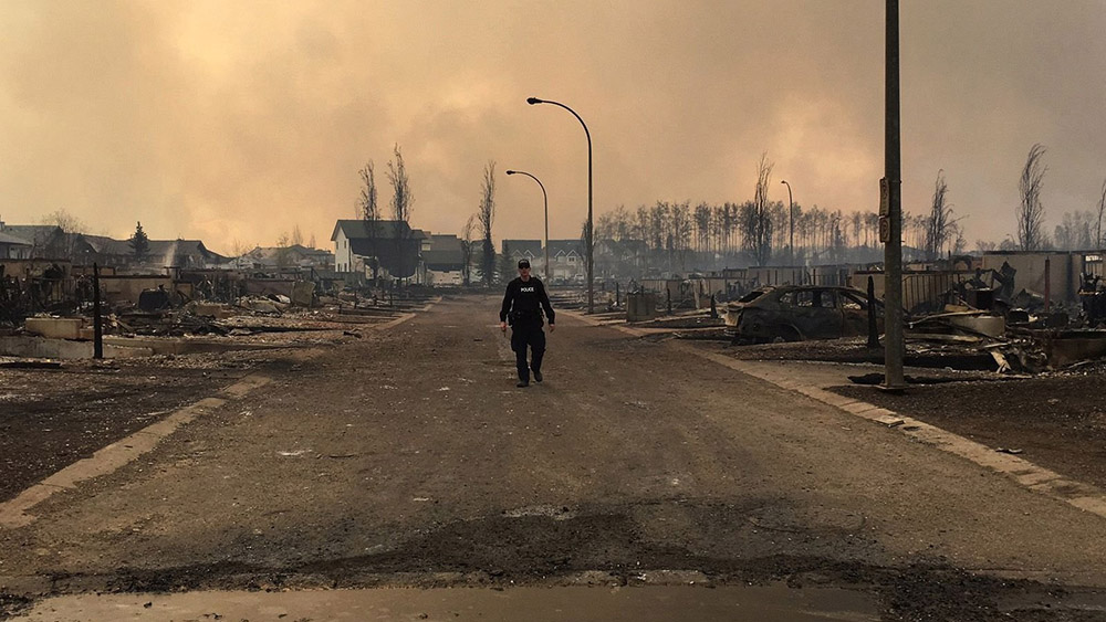
A police officer walks past burned homes in Fort McMurray, Alberta, Canada May 5, 2016. AFP photo / Alberta RCMP / HO
A study on the health of Royal Canadian Mounted Police (RCMP) officers who were deployed in Alberta, Canada in 2016 to the Horse River Fire at Fort McMurray found that their airway function was compromised in the first three months after deployment. An analysis of health data from 218 officers revealed that the small airways in their lungs underwent structural changes after they were deployed, potentially increasing their risk for respiratory diseases in the future. The median exposure duration of the officers was eight days.
“We cannot tell from our study whether it’s long-lasting damage, but we do know from other studies that if people are exposed to high levels of particulate matter in the air, they are more likely to suffer from long-lasting damage to the lungs,” said Paige Lacy, professor of medicine at the University of Alberta and former director of research for the Alberta Respiratory Centre.
The Horse River Fire caused the largest evacuation in Canadian history, with more than 80,000 people rapidly removed from the community as fires encroached on the city. Hundreds of RCMP members were sent to the community to assist with the evacuation and to secure the area in the following days. The fire burned 589,552 hectares (1.4 million acres) in 2016 and destroyed 2,400 structures. The extreme fire behavior created lightning in the pyrocumulonimbus cloud atop the smoke column that started a number of new wildfires 40 kilometers (26 miles) ahead of the main wildfire front according to a report released in June of 2017.
These two fires started at about the same time on May 1, 2016 near Fort McMurray, Alberta, Canada. On the left is the MMD-004 fire inside the city limits of Fort McMurray. The Horse River Fire, often referred to as the Fort McMurray Fire, is on the right.
Subtle changes in lung function detected
The lung-function data were gathered as part of a larger study being conducted by Synergy Respiratory and Cardiac Care, looking at the health of RCMP officers dispatched to the Fort McMurray wildfire. According to the researchers, the subtle differences in lung function that were found were not measurable using traditional lung-function tests, and could only be observed through the use of more sensitive instruments. Researchers employed both spirometry and body plethysmography testing methods.
“Small airways are potentially more vulnerable and there is no way that a spirometer (a device commonly used to measure lung function) can detect the progression of their damage over time,” said Subhabrata Moitra, first author on the study and a post-doctoral fellow in the U of A’s Division of Pulmonary Medicine. “So if we use highly sensitive instruments, we can immediately get some signals whether there are any acute yet subtle changes caused by physiological factors or occupational or environmental hazards.”
The researchers noted that because the officers only came in for testing once after being deployed, they were not able to observe potential recovery of lung function or measure long-term damage.
The authors of the study pointed out the importance of having a health-surveillance program in place so responders who are exposed to such hazards can have their health monitored.
Survey finds that firefighters also complained of respiratory issues
A survey found that some firefighters who fought the fire at Fort McMurray also battled respiratory and mental health issues.
The University of Alberta study surveyed 355 firefighters and found a “very large proportion” of them complained of respiratory issues including coughing, breathlessness, wheezing and chest tightness in the immediate aftermath of the fire.
“When we saw them later, probably about one in five of those still had problems with their chests that they felt had been caused or made worse by the fire,” said Nicola Cherry, the epidemiologist leading the study.
And they’re battling more than just physical ailments — mental-health issues affect one in six of study participants.
“When we collected this information, it was early days and people may develop bigger issues as time goes forward,” Cherry said.
Our Take
It is likely that wildland firefighters are routinely exposed to far higher concentrations of smoke and for longer periods of time than the RCMP officers at Fort McMurray. It is important that agencies who employ wildland firefighters establish a health-surveillance program that includes lung function tests using methods such as body plethysmography that are much more sensitive than a conventional spirometer.
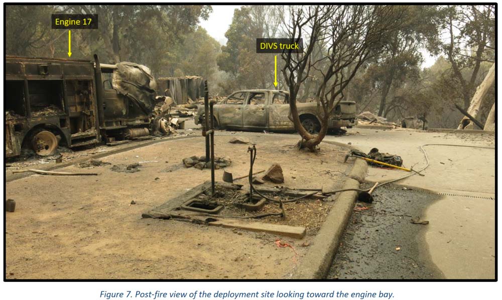
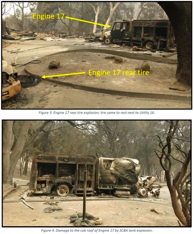
The Nacimiento guard station, two fire engines, several personal vehicles, and two dozers burned — there was one very serious injury
Dolan Fire deployment site. Engine & pickup. Image from the report
Several “learning reports” have been released by the U.S. Forest Service about the burnover and entrapment one and a half years ago of wildland firefighters at a remote fire station. It occurred on the Dolan Fire on the Los Padres National Forest in Southern California September 8, 2020. Fifteen firefighters deployed into only 13 fire shelters. Four firefighters were injured and three were hospitalized. One had very serious burns.
The Dolan Fire had been burning for weeks but there were about half a dozen other fires in California that were larger, some much larger such as the LNU Lightning Complex, SCU Lightning Complex, CZU August Lightning, and the August Complex.
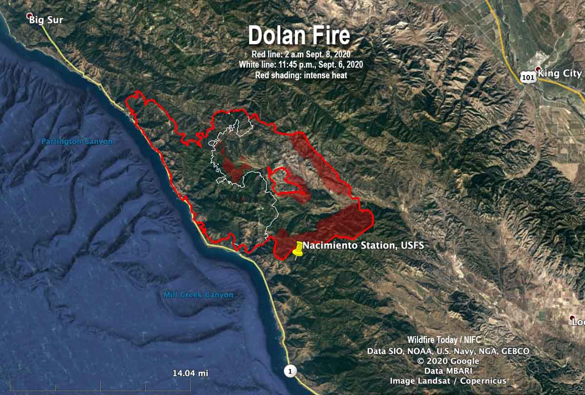
The Incident Management Team ran a modeling scenario on September 4 which showed that within the next 14 days the probability of the fire reaching the Nacimiento Guard Station was 60 to 80 percent with no delaying tactics. At that time the fire was 3.1 miles away.
The night before the fire reached the station on Nacimiento-Fergusson Road 7 miles from the highway on the California coast, the fire ran for about three miles toward the station, burning 30,000 acres with spot fires three-quarters of a mile ahead. The map below based on infrared data shows the growth in the 26-hour period ending at 2 a.m. on Sept. 8. The fire hit the station between 7 and 8 a.m. on September 8.
Map of the Dolan Fire. The red line was the perimeter at 2 a.m. PDT September 8, 2020. The white line was the perimeter about 26 hours earlier. The red shaded areas indicate extreme heat.
When the fixed-wing aircraft mapped the fire five or six hours before the incident, it had burned about 74,000 acres, more than twice the size mapped the previous night. The sensors on the plane detected intense heat on the southern edge of the fire, 0.7 miles north of Nacimiento Station.
The fire personnel at the station during the burnover included two USFS engine crews, two dozers with operators, and the only Division supervisor working the night shift — due to a shortage of personnel. Other overhead at the fire may have been distracted as a newly established Incident Command Post had to be evacuated and relocated as the fire approached in the middle of the night.
Dolan Fire deployment site. Engine 17. Image from the report.
Several of those involved at Nacimiento believed there was no way to defend the station even though a hand crew had cleared some vegetation, a hand line had been dug, and there were hose lays around the structures. With that work done and the fact that the station had survived other fires, some of the locals said they could protect the buildings and the personal belongings and vehicles of the fire personnel who lived there.
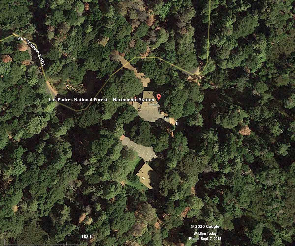
Below is an aerial photo of the Nacimiento Guard Station taken almost exactly two years before the burnover. It appeared in an article on Wildfire Today about the entrapment published September 11, 2020.
Nacimiento Station, satellite photo, September 7, 2018.
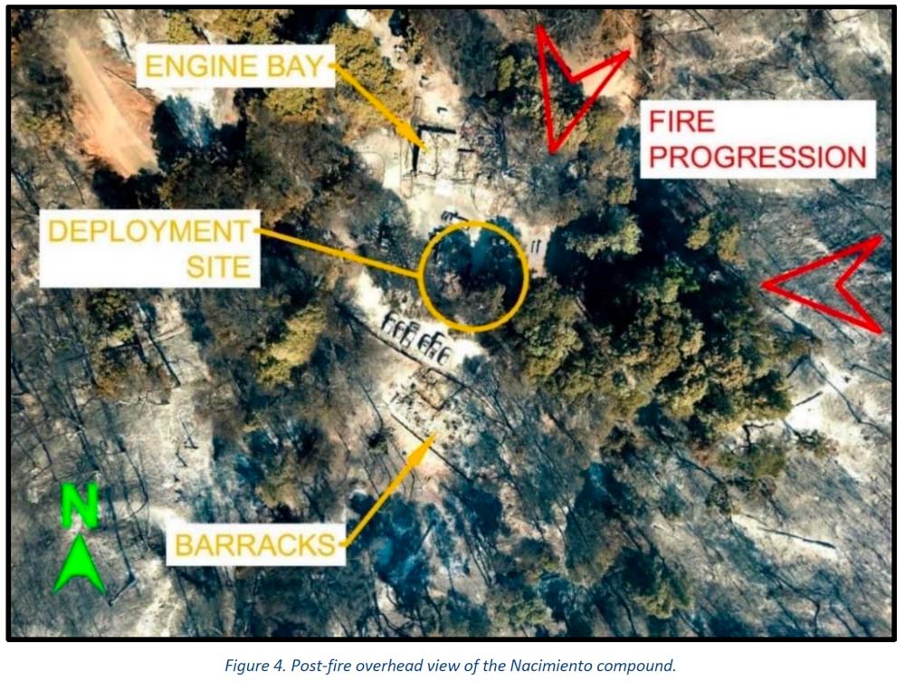
The photo below was taken after the burnover.
Dolan Fire deployment site, aerial photo. Image from the report.
This is the first paragraph in the Learning Review — Narrative:
Smoke is billowing out of the barracks and hot embers are raining down all around. Engine 16 is on fire. The engine bay is on fire. Marty can’t get his pack out of the burning engine, which means he can’t get to his fire shelter. He’s just standing there, and Rene can’t get his attention. She has her shelter out, ready to go. She hits him, but he just stands there. She hits him again, but he still just stands there. Marty is not ready to commit to the shelter; he’s thinking about potential dangers from the propane tanks around them, and that more needs to or could be done. Rene hits him again and pulls down on his shirt to get him down to the ground and into the fire shelter. Rene tucks the fire shelter around him and cinches it in tight under his arms and legs. She takes a quick look around and then climbs in under the shelter with him. Eleven other firefighters are deployed around them in the parking lot of the Nacimiento guard station. The heat inside the shelters was stifling. “I could feel the skin tightening on my face. Mucous was coming out of my nose and eyes, hanging off my chin. I felt like all the fluid was being roasted out of me. My throat was so sore I could barely drink my water.” Everyone is asking the same question: “How did we get here?”
“If we preach it, we should do it.”
The Organizational Learning Report has a section, Theme 3, pointing out that even though the Forest Service has “preached [to homeowners] FireWise concepts for decades” about how to reduce the chances of their houses burning as a wildfire approaches, too many of the agency’s own structures lack FireWise status. The report says, “If we preach it, we should do it. ”
We asked Kelly Martin for her thoughts about the reports on the Dolan Fire. She is the current president of Grassroots Wildland Firefighters and the retired Chief of Fire and Aviation for Yosemite National Park. She replied by text:
The biggest thing that comes to mind is our over confidence in what we deem ‘defendable’ until the time wedge becomes too small to make safe, proactive decisions. The oppressive personal/social pressure to protect treasured places puts us in an untenable situation to champion the notion, ‘not on my watch’ are we going to lose this place. The protection narrative gets repeated and reinforced by the majority who consider it ‘their home turf’ and unfortunately tend to dismiss many ‘outsiders’ objective perspectives on the situation that might help reduce the deep personal attachment to ‘home turf.’ Having ‘Outsiders’ become part of the decision making process can help enhance rational decision making.
Confirmation bias may have been a factor. The fire station survived previous fires, thus lulling us to previous events rather than fully appreciating the situation we now find ourselves in with excessive fuel buildup.
Also, I think the Wildfire Decision Support System (WFDSS) process and further high level local management and Incident Management Team analysis should have spotted this mindset trap early on.
Our Take
The disaster at the Dolan Fire is yet another example where knowing the real-time location of the fire may have made a difference. The Captain who ran the station and some other locals believed that they needed to protect the facility and insisted that they COULD. Others thought differently but were not assertive enough or didn’t have the authority to override that decision. They knew the fire was approaching. But would things have turned out differently with others who didn’t have emotional attachments to the buildings? Or who had real-time intelligence, and could “see” the locations of all resources as well as the entire fire — the very rapid rate of spread, the spot fires ¾ mile ahead, and the intensity? What if the Operations Section Chief, Branch Director, primary Safety Officer, or the Incident Commander had access to real-time video from a drone circling over the fire? Any one of those might have ordered the withdrawal of the engines, dozers, and 15 firefighters hours before they came close to death. They might have said, “Forget the damn structures. Think about the humans. Consider the physical and mental trauma those humans could suffer, perhaps for years.”
The decision to stay or go, in addition to human safety, should have also considered the dollar value of the personal belongings and vehicles of the employees who lived at Nacimiento. They were not evacuated days earlier even though the station was in a mandatory evacuation area. They trusted the Incident Management Team, the Forest overhead, and the Captains. How much will it cost those firefighters, on their meager salaries, to replace their personal vehicles and belongings? Then there is the cost to taxpayers of two engines, two dozers, and at least one pickup truck.
The technology has existed for years to provide real-time video of fires 24 hours a day. The John D. Dingell, Jr. Conservation, Management, and Recreation Act required that by September 12, 2019 the five federal land management agencies “develop consistent protocols and plans for the use on wildland fires of unmanned aircraft system technologies, including for the development of real-time maps of the location of wildland fires.”
While this technology has been demonstrated and used sparingly, such as the FIRIS program, real-time mapping is far from being used routinely.
The Dingell Act also mandated that the five federal land management agencies “jointly develop and operate a tracking system to remotely locate the positions of fire resources for use by wildland firefighters, including, at a minimum, any fire resources assigned to Federal type 1 wildland fire incident management teams,” due by March 12, 2021.
The Bureau of Land Management has installed hardware for Location Based Services (LBS), which are now operational on more than 700 wildland fire engines, crew transports, and support vehicles. Vehicle position and utilization data are visually displayed via a web-based portal or mobile device application. Ten months after it was required by Congress, the U.S. Forest Service has made very little progress on this mandate.
Some other government facilities are also not FireWise
It is not just the Forest Service with structures that do not all meet FireWise standards. When I was an area Fire Management Officer for the National Park Service, two of the parks for which I was responsible were threatened on different occasions by wildfires. Although the threat was low to moderate, I was able to convince the Park Superintendents that hazard reduction and thinning of the trees was necessary, now. It should have already been done, but seeing smoke in the air made it possible to make fast decisions and to get it accomplished very quickly. Up until then, removing any tree near park headquarters was a tough row to hoe. Neither fire spread into the parks, but the long-delayed and badly needed work got done. And I slept better.
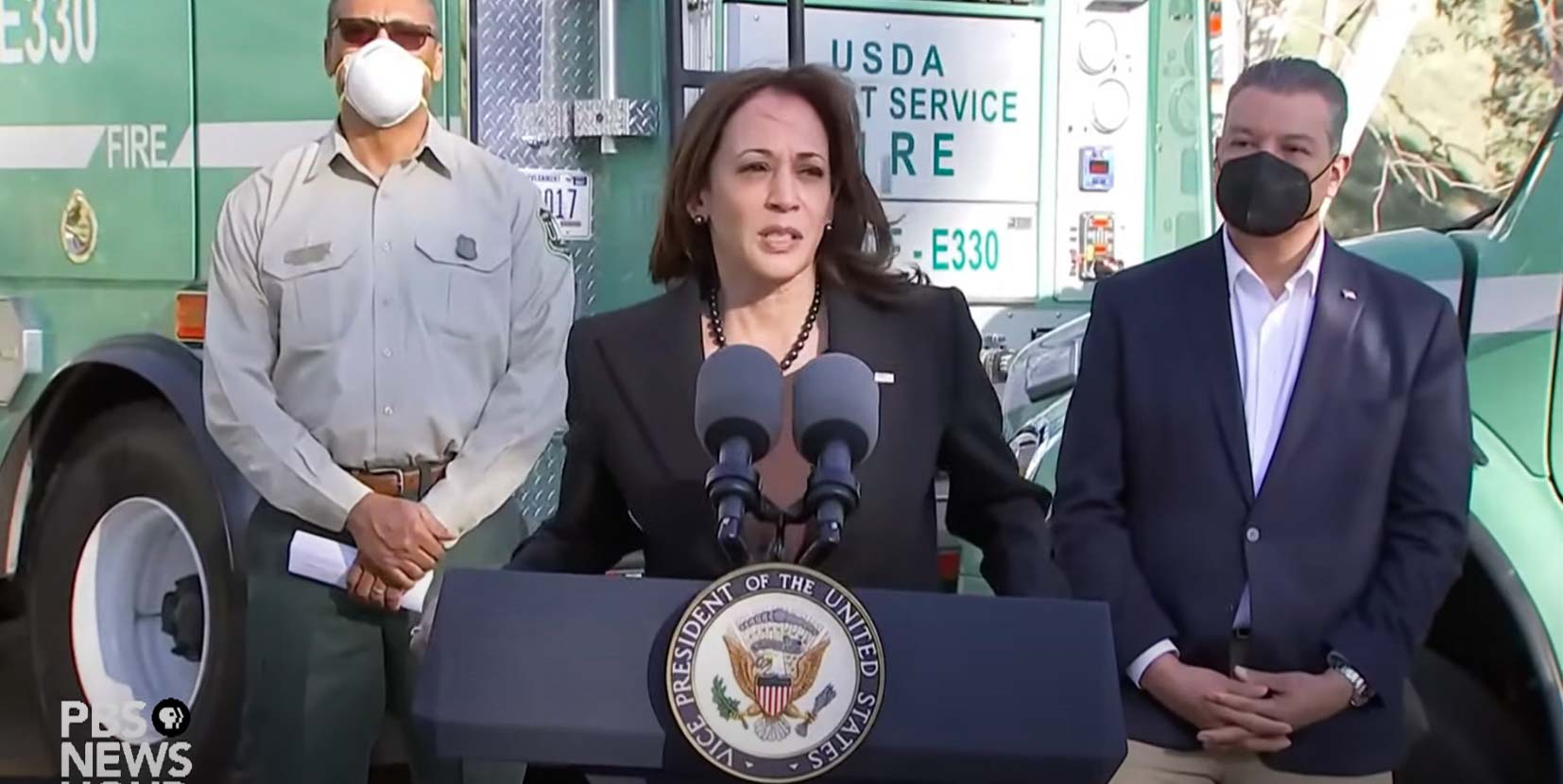
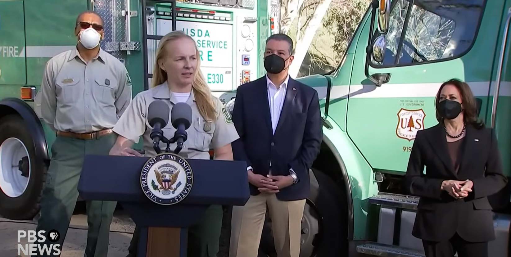
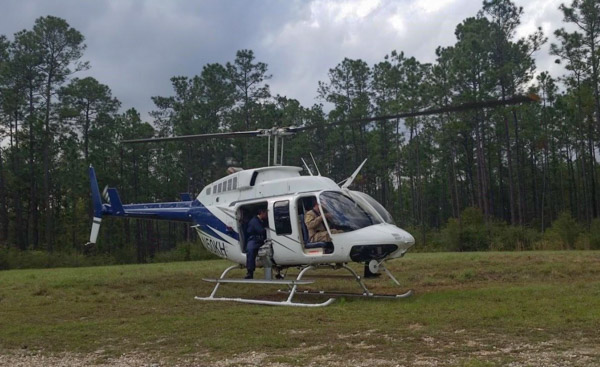
At Del Rosa fire station in Southern California the VP was introduced by a wildland firefighter
Vice President Kamala Harris at the San Bernardino National Forest, January 21, 2022.
On Friday Vice President Kamala Harris traveled to California where she spoke about wildland fires and the fact that federal firefighters are “underpaid given the nature and value of their work.”
Her 12-minute speech was made at Del Rosa fire station on the San Bernardino National Forest as she stood in front of US Forest Service fire apparatus, Engine 330 and a Del Rosa Interagency Hotshot crew buggy.
“On behalf of the President and myself I want to thank all the men and women who serve in such difficult times but always with such grace. Thank you Sarah and thank you Chief,” the Vice President said as she began her remarks. Sarah Hudson, a firefighter, introduced the VP. More about that below.
Later the Vice President mentioned the pay of federal wildland firefighters.
“There will be $5 billion, and more actually,” she said, “for wildfire preparedness and resilience, and it will include, and this requires its own conversation, a pay raise for our federal firefighters. And I invite everyone to become familiar with the history of this issue and for how long they have been underpaid given the nature and value of their work, and so we are very, very excited to acknowledge their work not only in words but with the pay that recognizes the value of the skill and the dignity of the work that they perform…And I am very proud of the folks who in particular are on the ground doing this work every day. As I have said before I will say again, you inspire us all.”
The Vice President spoke for 12 minutes about wildland fire and reducing their impact, and never mentioned raking the forest.
She also covered the resilience of communities threatened by fire.
“We are talking with home owners and reaching out to communities,” she said, “to figure out how we can support them to create a community that is less likely to be so significantly damaged if a fire should hit.”
The Home Ignition Zone should be an extremely high priority in preventing structures from burning as a wildfire approaches.
“Surprisingly, research has shown that home ignitions during extreme wildfires result from conditions local to a home,” wrote retired US Forest Service Research scientist Jack Cohen in a 2020 article on Wildfire Today. “A home’s ignition vulnerabilities in relation to nearby burning materials within 100 feet principally determine home ignitions. This area of a home and its immediate surroundings is called the home ignition zone (HIZ). Typically, lofted burning embers initiate ignitions within the HIZ – to homes directly and nearby flammables leading to homes.”
Other speakers at the event included Secretary of Agriculture Tom Vilsack, California Governor Gavin Newsom, and Chief of the Forest Service Randy Moore.
Sarah Hudson, a US Forest Service firefighter with Heaps Peak Helitack, introduces Vice President Kamala Harris, January 21, 2022.
In addition to the dignitaries peaking at the event, Sarah Hudson, a senior firefighter on the Heaps Peak helitack crew on the San Bernardino National Forest made remarks and then introduced the Vice President. This may be the first time a wildland firefighter has performed such a feat. In her spare time Ms. Hudson serves in the California National Guard as a senior airman with the 163rd Attack Wing where she performs maintenance on ground support equipment for remotely piloted aircraft such as the MQ-9 Reaper. On several occasions a National Guard Reaper or similar National Guard drone have assisted firefighters by gathering real time imagery over ongoing wildfires in California.
The entire 35-minute event is covered in the video below.
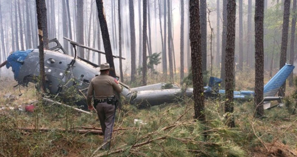
The National Transportation Safety Board has released their factual report on the crash of an AS350 helicopter that occurred March 27, 2019 during operations on a prescribed fire in Texas. Three people were on board, a pilot and two firefighters. The surviving firefighter and pilot were able to exit the helicopter; however, the second firefighter was partially ejected and sustained fatal injuries. The pilot suffered serious injuries and the surviving firefighter’s injuries were minor. The two injured personnel were transported to a hospital in stable condition after rescuers extracted them from the wreckage using jaws and air bags.
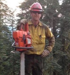
Daniel J. Laird. Tahoe National Forest photo.
The firefighter killed was Daniel Laird, a Captain on the Tahoe Helitack crew in California. He left behind a wife and young daughter.
Mr. Laird was a U.S. Forest Service employee who, along with the other firefighter and the pilot, were on an aerial ignition mission on the Sam Houston National Forest. Their equipment was dropping plastic spheres that burst into flame after hitting the ground, helping to ignite the prescribed fire. The ship came to rest outside the active area of the prescribed fire and there was no additional fire caused by the crash.
The pilot and surviving crew member reported that after completing the application of plastic spheres they began flying back to the staging area when the engine lost total power.
The March 27, 2019 helicopter crash in Texas. Photo by Sgt. Erik Burse/Texas Department of Public Safety.
Most NTSB accident reports are fairly straightforward, but this report, due to the way it is written, still leaves a small amount of doubt about the cause of the engine failure. However, signs point toward a loose fuel line.
“The fuel line between the firewall and hydro-mechanical unit (HMU) was loose and the required safety wire was not installed,” it says, and no other discrepancies were found. It does not say if the fuel line was loose enough to cause the engine to lose power.
From the NTSB report:
Federal Aviation Administration inspectors from the Houston Flight Standards District Office interviewed Mountain Air’s Director of Maintenance, who stated that on February 14, 2019, the USFS requested to validate the helicopter’s weight and balance. The helicopter was defueled, which involved disconnecting the main fuel line. After the weight and balance were verified, the main fuel line was reconnected. The director of maintenance asked another mechanic to verify that the fuel lines were reconnected, which was reportedly accomplished. The mechanic that accomplished the work informed the operator that he “was confident” that he torqued and secured the line. There was no other maintenance work which involved opening the fuel line after that day. On February 23, 2019, the helicopter’s engine would not light, and the engine’s igniters and/or igniter box was replaced. A maintenance records review found that the helicopter flew about 24.9 hours after the weight and balance was conducted on February 14, 2019.
On March 25, 2019, the pilot reported to management that the fuel pressure light had “flickered” during a flight “a few days before;” the pilot turned on the fuel boost pump, turned it off, and the light never reappeared. The pilot was informed to monitor the situation and report if it occurred again.
Following the accident, the digital engine control unit (DECU) was removed and sent to the manufacturer for data download. On April 11, 2019, the DECU was downloaded under the auspices of the FAA. The last recorded fault was a “P3 drift or engine flame out.”
The helicopter, N818MC, was owned Mountain Air Helicopters, Inc. The company has five other helicopters and a Cessna 414A registered with the FAA.
In 2015 two were killed in Mississippi under similar circumstances on a prescribed fire when engine failure brought down a helicopter conducting aerial ignition operations. A third person suffered serious injuries.
The helicopter involved in the March 30, 2015 incident in Mississippi, N50KH, is shown with doors removed and Pilot and PSD operator positions visible.
Our take
Flying low and slow in a single-engine helicopter while igniting fire below the aircraft is obviously very, very dangerous. These three fatalities offer very compelling justification for using drones for aerial ignition instead of manned aircraft.
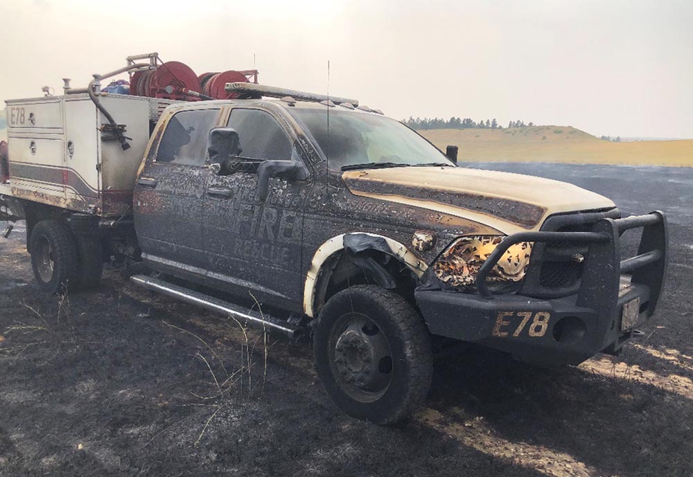
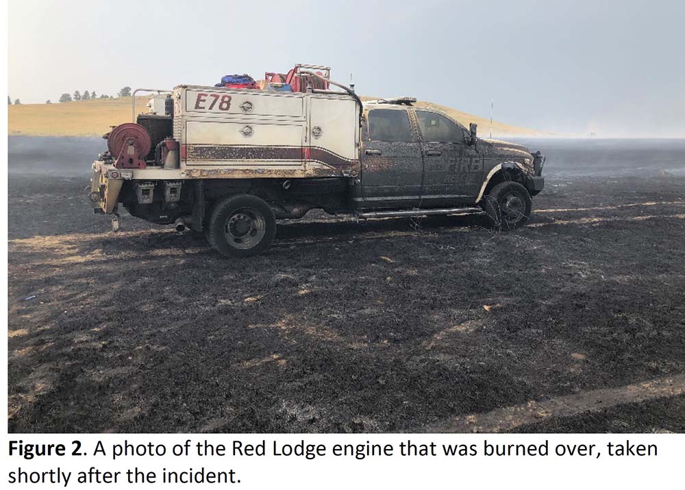
Engine in Harris Fire burnover — July 16, 2021. From the report.
A Facilitated Learning Analysis has been released for the burnover that occurred July 16, 2021 on the Harris Fire near Joliet, Montana 25 miles northeast of Red Lodge. Dan Steffensen of Red Lodge Fire Rescue who had six years of experience with wildland fire was on a two-person engine crew when very strong winds suddenly shifted. He attempted to reach safety, but was overrun by the fast moving fire and was injured. Due to the severity of his burns, 2nd and 3rd degree on 45 percent of his body, Mr. Steffensen was flown to the University of Utah Burn Center in Salt Lake City where he was treated for nine weeks.
Mr. Steffensen was operating a nozzle while he and another firefighter who was driving the engine were making a mobile attack on a grass fire. It was burning in pastureland that had not been burned, grazed, or hayed in six years, consisting primarily of dense grass and some sage approximately two feet in height.
In accordance with department common practice, Mr. Steffensen was not wearing his line pack and fire shelter, as neither he nor the driver would ever get past the end of the hardline hose. In that first section, Mr. Steffensen was always in the driver’s direct line of sight, and the three-to four-foot flames “took down easy” and quickly.
The firefighters did not know that minutes before the burnover the National Weather Service had issued a Significant Weather Advisory for thunderstorms moving in their direction. “Wind gusts of 50 to 60 mph are possible with these storms,” it said. “A gust to 63 mph was reported in Big Timber with this activity.”
When the wind gusts arrived at the fire, increasing from 10 mph to about 55 mph, a helicopter pilot who had been dropping water was forced to jettison the water from his bucket.
As the wind speed suddenly increased and the direction shifted, Mr. Steffensen and the engine were entrapped by flames. The firefighter driving the engine had no visibility and knowing there was a cliff nearby, stayed in place and let it burn over the engine. He later described it as being “hotter than hell in the cab” for the 20-30 seconds of the burnover. He was not injured.
From the report:
For Dan, those few seconds between when he recognized that they had a problem and when the flame front hit were not enough for him to return to the engine or reach the black. He later said “I’ve been on many fires, [and] I’ve never seen one come out of nowhere so fast. All it took was the wind switch.” Although he was only 15 or so feet from the burned portion of the field that he and Scott had just left, the fire was traveling too fast for him to get there. With no line gear on him, and no time to deploy a shelter even if he had carried it, he was left with just his PPE to protect him from the 20-foot high, fast-moving flame front, which hit him after slamming into the driver’s side of the engine and eddying under to the passenger side.
Below are the Key Takeaways from the report:
Almost every single experienced wildland firefighter reading this analysis will find the series of events recounted here familiar: an initial attack in light, flashy fuels with rapidly changing conditions. It can, therefore, be tempting to write this off as an unavoidable situation in an inherently risky profession. While the FLA team agrees that accepting some level of risk while fighting fire is inevitable, we do believe there are some key lessons for the reader to consider, should they ever find themselves in a similar situation.
1) Remember the importance of PPE and wearing it correctly. Dan’s injuries would have been much worse had he not been wearing his Nomex, a layered shirt, gloves, and a helmet in the appropriate manner.
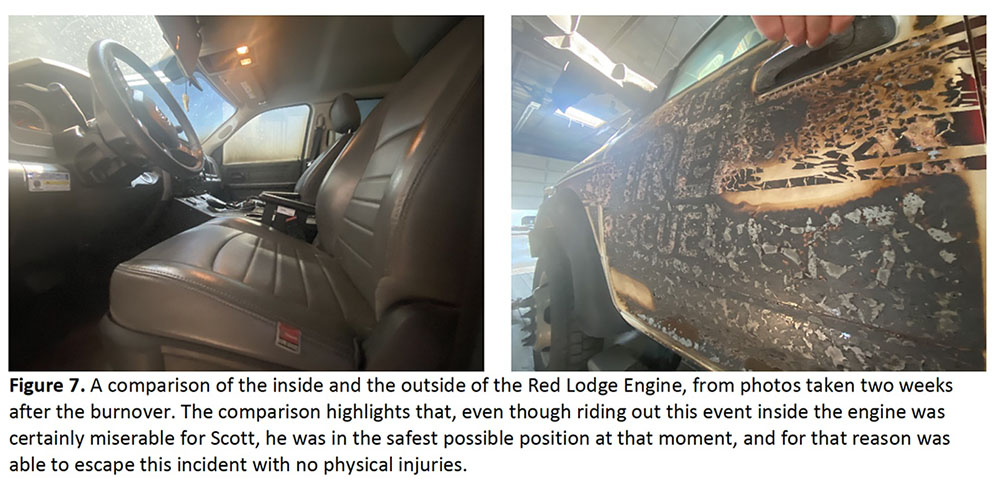
2) Remaining in your vehicle during a burnover may be the best option in light, flashy fuels. Scott was able to walk away from the Harris Fire that day with no physical injuries. The comparison of the conditions inside and outside of E78 suggest that this was the safest place he could have been in that moment.
We also encourage you to reflect on the following questions, especially as they relate to fast-moving initial attack scenarios:
1) When planning your escape route, how much time do you really have to react? It was repeated throughout this analysis, both from individuals involved in the incident and those not involved, how common it is in our current firefighting environment to operate outside of the black. In this case, however, there were some slightly unusual circumstances, such as the high grassy fuel loads, that contributed to the unintended outcome. Take the time to consider such factors, as well as harder to predict factors such as unexpected wind shifts, when planning an escape route.
2) Is the higher level of risk that comes with missing elements of LCES acceptable to you? If yes, what values must be threatened for you to accept that higher level of risk? When asked, Scott shared that his major lesson learned from the day was, “what were we doing here?” With time to reflect, he regretted entering an unburned area with an inadequate escape route to save a few acres of grass, especially when an alternate suppression strategy may have been as effective at keeping the fire on the plateau.
3) What is the process in your organization for quickly communicating special weather statements and advisories about changing conditions? In this case, the special weather statement was issued only minutes before the thunderstorm impacted wind speed, direction, and fire activity at the scene, and no one on the fire received this information in time to react and reevaluate their tactics.
4) When the forecast restates the same thing every day, how do you ensure that you still account for the potential impacts of extreme weather during initial attack? Even if those on the hill had received the special weather statement in a timely manner, it had been hot and dry with a chance of thunderstorms in the area for weeks. Such repetition during fire season often results in the line of thinking that “nothing bad happened yesterday, so today we should be fine again.” Even for the most experienced firefighters, extreme fire weather should still be of note; in fact, these are often the firefighters that must battle most against complacency to objectively consider the potential risk posed by extreme fire weather.
5) Is your assessment of fuels valid? Just as in timber litter fuel types, there can be significant variations in grass fuels with regards to fuel loading and arrangement. In many areas of the west, grazing lands are enrolled in conservation programs that govern the frequency of grazing, haying, or burning, resulting in significantly higher amounts of fuel on the ground. How do you make sure that your assumptions about fire behavior and spread rates are still valid as you make decisions about tactics?
It will use $2.42 billion authorized by the infrastructure bill for fiscal years 2022 through 2026 for fuels-related projects
Geronimo Hotshots on the Big Windy Complex, Oregon, 2013. USFS photo by Lance Cheung.
On Tuesday the U.S. Forest Service announced a 10-year strategy to address what they call the wildfire crisis which poses immediate threats to communities. The initiative, called “Confronting the Wildfire Crisis: A Strategy for Protecting Communities and Improving Resilience in America’s Forests,” combines the recent large investment funded by congress with years of research and planning into a national effort that is intended to significantly increase the scale of forest health treatments over the next decade.
The Forest Service will work with other federal agencies, including the Department of the Interior, and with Tribes, states, local communities, private landowners, and other partners to focus fuels and forest health treatments more strategically and at a larger scale.
Funding was approved in November
The Bipartisan Infrastructure bill signed by the President November 15, 2021 authorized about $2.42 billion for fiscal years 2022 through 2026 for fuels-related projects. (M = million)
$100M, Pre-fire planning, and training personnel for wildland firefighting and vegetation treatments
$20M, Data management for fuels projects and large fires
$100M, Planning & implementing projects under the Collaborative Forest Landscape Restoration Program
$500M, Wildfire defense grants for at risk communities
$500M, Prescribed fires
$500M, Constructing fuelbreaks
$200M, Remove fuels, produce biochar and other innovative wood products
Previous testimony about fuel management before congressional committees
During testimony June 17, 2021 before the Senate Committee on Energy and Natural Resources former US Forest Service Chief Vicki Christiansen said the agency treats fuels on about three million acres each year but said they need to treat two to four times that amount. She repeatedly called for a “paradigm shift” for treating hazardous fuels. Senator Ron Wyden (OR) got Ms. Christiansen to confirm that the agency’s latest estimate is that it would take $20 billion over a 10-year period to “get in front of the hazardous fuel challenge”.
On September 29, 2021 in a hearing before the House of Representatives Agriculture Committee’s Subcommittee on Conservation and Forestry, new USFS Chief Randy Moore said, “We will never hire enough firefighters, we will never buy enough engines or aircraft to fight these fires. We must actively treat forests. That’s what it takes to turn this situation around. We must shift from small scale treatments to strategic science-based treatments across boundaries. It must start with those places most critically at risk. We must treat 20 million acres over 10 years. Done right in the right places, treatments make a difference.”
On October 27, 2021 Jaelith Hall-Rivera, Deputy Forest Service Chief for State and Private Forestry told the House of Representatives’ Subcommittee on Natural Resources, “We need to treat an additional 20 million acres over the next decade and that could cost up to $20 billion or more.”
What is now planned
The plan released Tuesday by the Forest Service calls for:
Treating up to an additional 20 million acres on the National Forest System lands in the West, over and above current treatment levels;
Treating up to an additional 30 million acres on other Federal, State, Tribal, and private lands in the West;
The current level of treatment in recent years has been 2-3 million acres per year for fuels and forest health, the new document stated.
The plan calls for an unprecedented “paradigm shift” in land management to increase fuels and forest health treatments across jurisdictions to match the actual scale of wildfire risk to people, communities, and natural resources, especially in the Western United States.
The Forest Service is developing staffing plans and will be increasing capacity in not only field personnel specializing in prescribed fire to complete the work but also key administrative positions like contracting officers, human resources professionals, collaboration and partnership coordinators, communications, and grants and agreements specialists who will assist in connecting with partners.
During the first two years of the initiative, the agency will be looking for large landscape-scale projects that are ready to go, up until now lacking only the necessary funding.
They will be seeking projects that are:
Designed to reduce wildfire risk to communities, water supplies, or critical infrastructure (including utility lines, roads, and national security sites);
Critical ecological values (including watersheds, wildlife habitat, and old growth stands) and ecosystem services (including carbon storage);
Economic values (including outdoor recreation, timber, and grazing areas);
Areas of cultural and historic significance (including areas important to Tribes); and,
Areas of social importance to communities (including for access and subsistence use).
Reforestation
The new initiative also strives for increased rates of reforestation following forest fires.
“We currently address only 6 percent of post-wildfire replanting needs per year, resulting in a rapidly expanding list of reforestation needs,” the new plan states. “We have plans for the reforestation of more than 1.3 million acres of National Forest System land. However, these plans only address one-third of National Forest System reforestation needs, estimated to be 4 million acres and growing. As we work to recover from wildfire, we are emphasizing planting the right species, in the right place, under the right conditions, so forests will remain healthy and resilient over time.”
Our take
The testimony before congressional committees said that in order to “get in front of the hazardous fuel challenge” and “turn this situation around” the Forest Service needs an additional $2 billion a year for the next 10 years, over and above what is currently being spent. What was appropriated for the next five years was about $0.48 billion per year, less than one-fourth of the additional funds the agency said was needed.
The growth of the climate crisis which has contributed to the “wildfire crisis” appears to be exceeding the estimates of scientists. Changes are occurring even more quickly than previously expected. So low-balling the funding for protecting our homeland will mean we will fall even further behind in treating fuels and attempting to keep fires from wiping out more communities.
The heads of the five federal land management agencies need to be honest with congress and continue to point out the scope of the fuels problem and the increasing risk of fiddling while the forests and subdivisions burn. Congress must accept the facts and pass legislation adequate to address the threats to our ecosystems and communities.