Fire mapping plane assists in rescue of 10 military personnel

Search and rescue operation underway in Rocky Mountain National Park in Colorado.

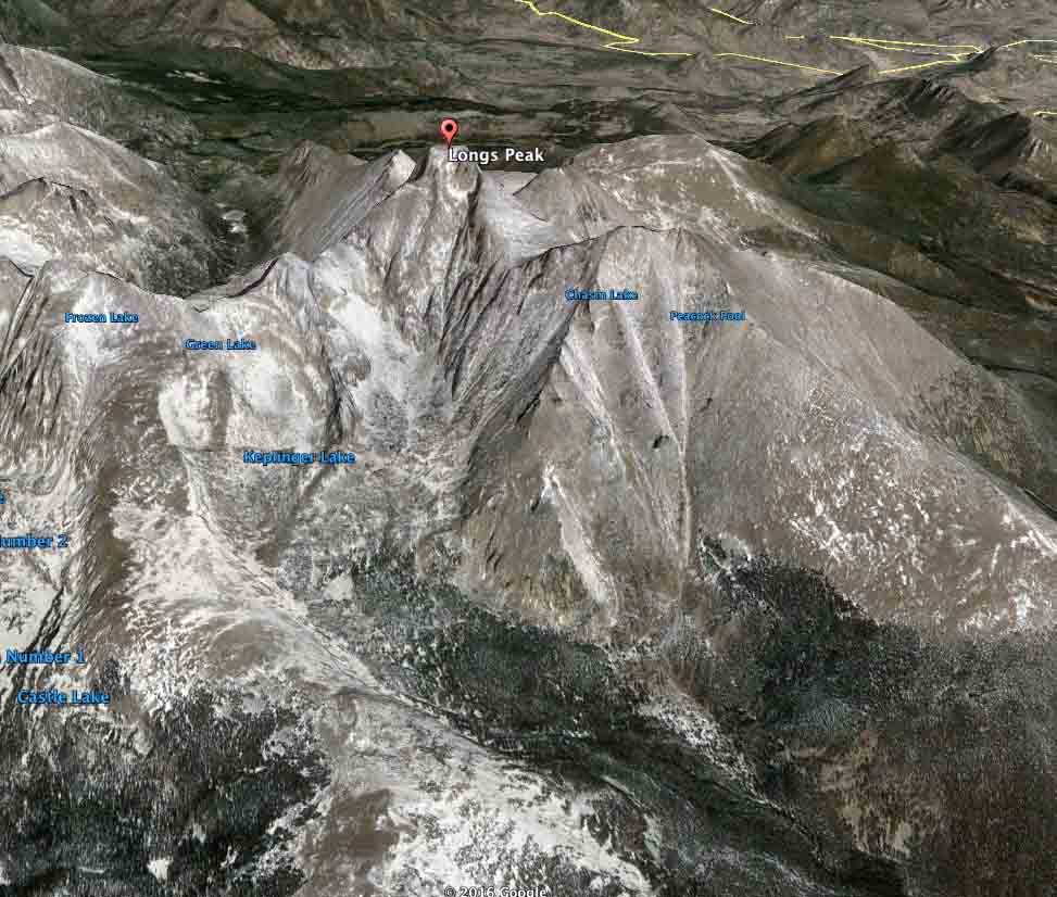
Longs Peak map
3-D map of Longs Peak in Rocky Mountain National Park, 10 miles southwest of Estes Park, Colorado. Google Earth.

(UPDATED at 2:10 p.m. MDT, June 3, 2016)

Helicopter rescue hikers
A helicopter extracts military personnel from the summit of Longs Peak at 1:42 p.m. MDT, June 3, 2016. Screen grab from TheDenverChannel video.

Ten soldiers, some of them with the 10th Special Forces Group based at Fort Carson, are being rescued from Longs Peak in Rocky Mountain National Park. Between 1:30 and 2 p.m. MDT TheDenverChannel streamed live video of a helicopter extracting personnel from the summit of the peak which is about 48 miles northwest of downtown Denver.

Kyle Patterson, a public affairs officer for the Park, said the state’s Pilatus PC-12 Multi-Mission Aircraft was used for reconnaissance. At 12:19 p.m. MDT she stated:

Late last night, Rocky Mountain National Park staff were notified that a group of ten people were requesting assistance on Kiener’s Route on Longs Peak.  The group consists of a variety of military personnel affiliated with Fort Carson.  This group was involved in a climbing training.  A few members reported having some degree of distress and were having difficulty continuing up the route. The group was not planning to over-night in the area.  The group continues to self-rescue by assisting each other to climb to the summit of Longs Peak.

Park rangers are planning evacuation efforts from the summit of Longs Peak via helicopter, weather and conditions permitting.  Rangers are also planning to assist the group to the summit, if needed.  There are forty-three park personnel affiliated with this incident.  Helicopter operations have taken place within the last hour to help with reconnaissance efforts.

Lt. Colonel Sean Ryan, a spokesman for the 10th Special Forces Group based at Fort Carson, confirmed this is a Green Beret unit.

Ryan said two members of the group got altitude sickness. He stressed that no one is missing and that altitude sickness can be a factor in mountain training.

****

(Originally published at 12:11 p.m. MDT, June 3, 2016)

An aircraft normally used for detecting and mapping wildfires has been mobilized to assist in the rescue of 10 overdue military personnel in Rocky Mountain National Park. The location is centered around Longs Peak which is 10 miles southwest of Estes Park, Colorado and about 48 miles northwest of downtown Denver.

This is a developing story which we will update as more information is available.

According to the Colorado Division of Fire Prevention and Control, one of their recently acquired Pilatus PC-12 Multi-Mission Aircraft is being used in the search. Sensors on the planes can detect and map the location of fires and transmit near real-time spatial data, still images, and short video clips to the Colorado Wildfire Information Management System (CO-WIMS), a web-based situational awareness platform. The infrared sensors may be able to detect the heat signatures given off by the overdue personnel. As you can see by the 3-D map above, the Longs Peak area is very steep and rugged, a difficult area for ground searchers to cover.

PIlatus PC-12 Colorado
One of Colorado’s two Pilatus PC-12 “Multi-mission Aircraft” at McClellan Air Field, March 23, 2016. Photo by Bill Gabbert.

Colorado's Pilatus PC-12 "Multi-mission Aircraft"
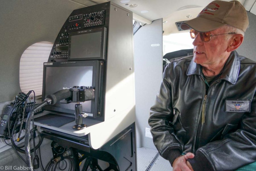
Guy Jones, one of the pilots for Colorado’s Pilatus PC-12 “Multi-mission Aircraft”, explains the sensing capabilities of the aircraft’s equipment at McClellan Air Field, March 23, 2016. Photo by Bill Gabbert.

Interior Secretary Sally Jewell talks about recovery at the Soda Fire

Secretary Jewell discusses the rehab of the Soda Fire and the illegal occupation of a National Wildlife Refuge.

In an interview with Rocky Barker of the Idaho Statesman, Secretary of the Interior Sally Jewell talked about the rehabilitation of the Soda Fire that burned 279,000 acres in Oregon and Idaho southwest of Boise last August. She addressed some of the criticism about the rehab strategy and also talked about the illegal occupation of the Malheur National Wildlife Refuge in Oregon and its effect on the U.S. Fish and Wildlife Service employees.

Map Soda Fire
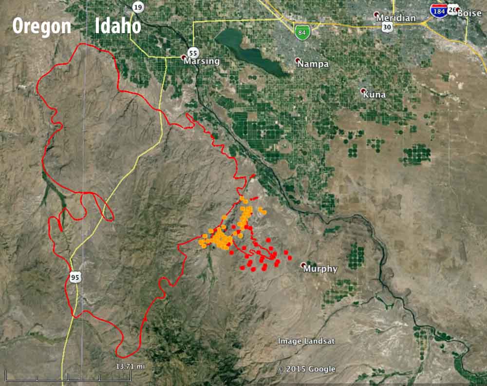
Map of the Soda Fire (red line) at 9 p.m. MT, August 14, 2015. The brown and red dots represent heat detected by a satellite as late as 10:05 p.m. MT, August 14, 2015. The fire was actively spreading near the location of the red dots at that time — the red dots were the most current. (click to enlarge)

Do California’s beetle-killed trees constitute an emergency?

Western Pine BeetleSome of the forests in California are experiencing a natural phenomenon that other areas in the Rocky Mountains, the Pacific Northwest, and British Columbia have been dealing with for years. Pine beetles, in this case Western Pine Beetles (WPB), are attacking and killing millions of trees. These things run in cycles and in this case the extended severe drought in the state has stressed the trees making it more difficult for them to fend off insects.

Politicians, residents, and even some individuals in fire organizations look at the hillsides with numerous dead or dying trees and intuitively think — dead vegetation — increased wildfire hazard.

Here are examples from the California Department of Forestry and Fire Protection (CAL FIRE):

From a 2015 news release:

These dead and dying trees create an environment more readily susceptible to dangerous and destructive wildfires.

In a video on YouTube the narrator says when referring to a beetle-attacked stand of trees:

…an increase in extremely flammable vegetation which could lead to larger, more intense and damaging wildfires.

SFGate quoted spokesperson Daniel Berlant:

“No level of rain is going to bring the dead trees back,” Berlant said. “We’re talking trees that are decades old that are now dead. Those larger trees are going to burn a lot hotter and a lot faster. We’re talking huge trees in mass quantity surrounding homes.”

A phone call to Mr. Berlant was not returned.

Those warnings are not 100 percent accurate. In increasing numbers, scientists are determining that generally, insect damage reduces burn severity. In one of the more recent studies, researchers from the University of Vermont and Oregon State University investigated 81 Pacific Northwest fires that burned in areas affected by infestations of two prevalent bark beetle and defoliator species, mountain pine beetle (Dendroctonus ponderosae) and western spruce budworm (Choristoneura freemani). The fires spanned the years 1987 to 2011.

Pine trees killed by bark beetles
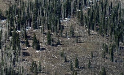
Pine trees killed by bark beetles. Photo by Ethan Miller.

Few of the 81 fires occurred in forests while the needles were still on the trees in the red highly flammable stage of the outbreak shortly after the trees were killed by mountain pine beetles, so more research is needed about this phase. Aside from the one to two year red stage, the burn severity decreased for more than 20 years following a MPB attack. It makes sense that fewer fine fuels in the canopy would reduce the fire intensity and make it less prone to transition from a ground fire to a crown fire. This data was derived from fire behavior and data on actual fires, not laboratory experiments.

We contacted one of the researchers that conducted the study in the Pacific Northwest, Garrett Meigs, a Postdoctoral Research Associate at the University of Vermont, and asked him if their conclusions about reduced fire severity following a Mountain Pine Beetle attack in the Northwest could be compared to California’s situation — a drought combined with a Western Pine Beetle attack:

I am aware of the impressive amount of tree mortality in California but have not seen it with my own eyes. As such, I am hesitant to comment on the current conditions in California forests, which are beyond the scope of our recent studies in Oregon and Washington. My understanding is that most of the dying/dead trees are ponderosa pines, which have been affected by intensive drought and the western bark beetle (whereas in the PNW, we studied lodgepole pines affected by mountain pine beetle and mixed-conifers affected by western spruce budworm).

Another thing that is a bit different in California is that many of these forests are generally closer to large human populations, so there are more human values/resources at risk…and these forests at the wildland-urban interface have elevated fuel/fire hazard with or without dead trees (whether caused by insects or drought).

Regarding your specific questions, I would expect that fire behavior and effects would be similar in forests with similar amounts of dead trees, whether the tree mortality was caused by bark beetles or drought (or some combination).

This does not mean that residents near insect-damaged forests can ignore the dead trees. There is legitimate cause to be concerned about fires during the one or two year red needle stage after a pine beetle attack when fire intensity may be temporarily increased, although more research studying actual fires is needed in this area. And there is danger from falling snags (dead trees) 5 to 20 years after an attack. Snags are dangerous for firefighters and any structures, hikers, traffic on roads, and any improvements that could be damaged by the falling trees.

In a fire prone environment, residents should remove any dead vegetation within 100 feet of structures. If there are numerous trees near homes, thinning them so that the crowns are at least 10 feet apart will not only reduce the intensity of an approaching wildfire, but will make more water and nutrients available to the remaining trees, giving the them a better chance of fighting off an insect attack.

California: Chimney Fire causes evacuations northwest of Indian Wells

(UPDATED at 2:56 PDT June 2, 2016)

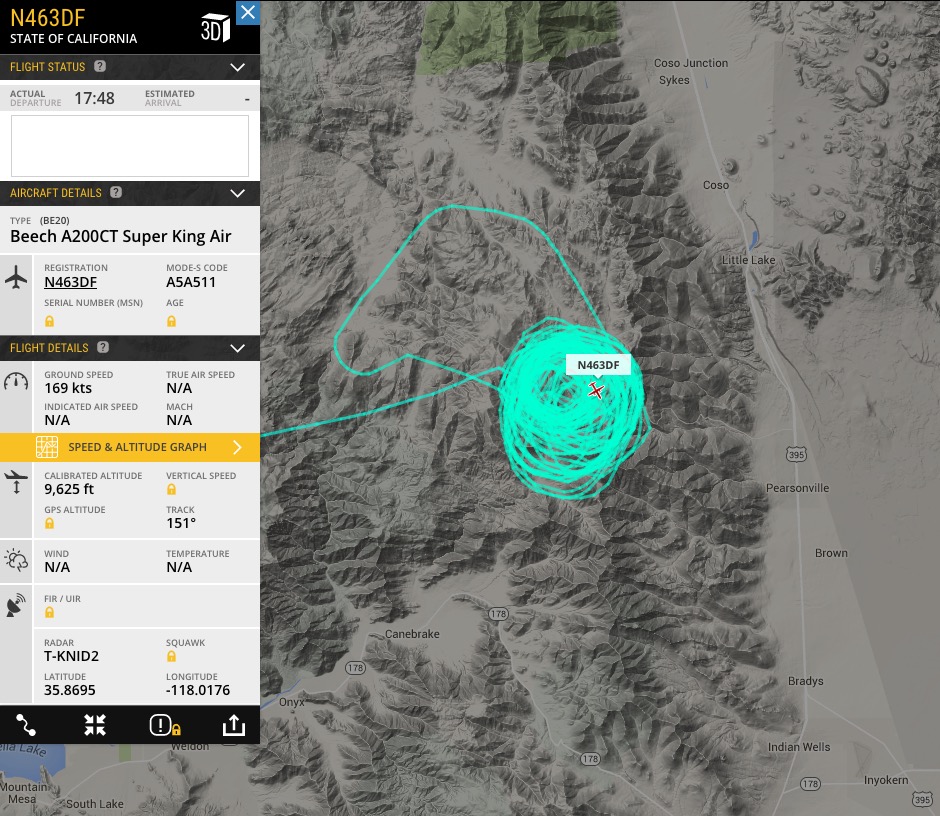
The CAL FIRE air attack ship appears to have located the Chimney Fire.

CAL FIRE Air Attack N463DF

****

(Originally published at 11:05 a.m. PDT, June 2, 2016)

Chimney Fire
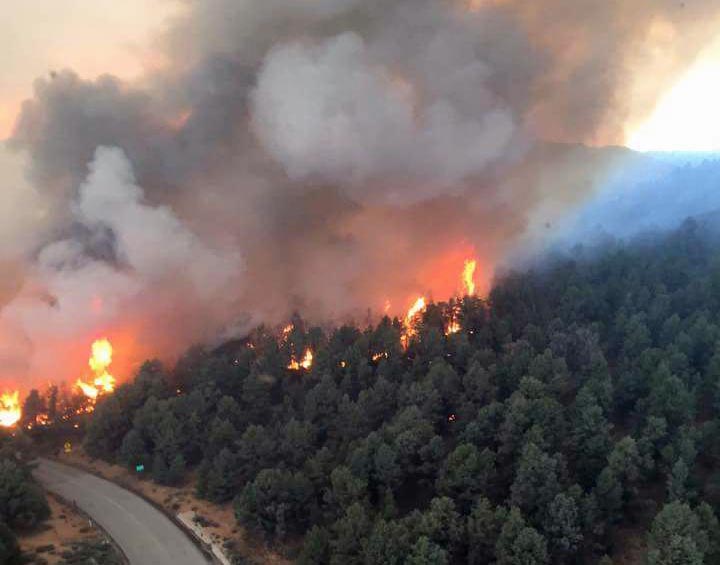
Chimney Fire, June 1, 2016. CAL FIRE photo.

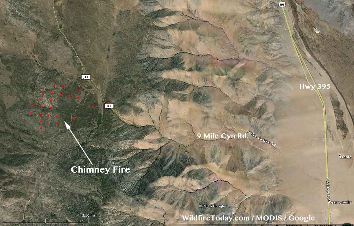
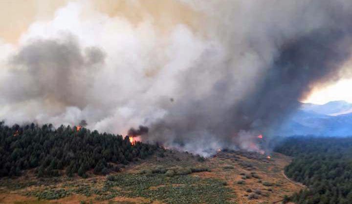
The Chimney Fire has caused evacuations in the community of Chimney Rock in California. Since it started on Wednesday, it has burned approximately 1,000 acres, and is located 7 miles west of Highway 395, 15 miles northwest of Indian Wells, and 25 miles northeast of Isabella Lake.

The video below was shot on Wednesday and gives a good overview of the fire at that time.

The fire is burning on Bureau of Land Management public lands in and adjacent to the Owens Peak and Chimney Peak wilderness areas. The Pacific Crest Trail, Nine Mile Road, and Canebreak Road are closed. Approximately 300 firefighters were on scene Thursday morning.

map Chimney Fire
Vicinity map of the Chimney Fire.
map Chimney Fire
The red dots on the map represent heat on the Chimney Fire detected by a satellite at 2:39 a.m. PT, June 2, 2016.

The National Weather Service forecast for the fire area Thursday afternoon predicts a temperature of 73, 16 percent relative humidity, and winds out of the south and southeast at 10 mph, increasing to 10 to 23 mph out of the west and northwest after 6 p.m.

A Type 2 incident management team, with Incident Commander Mills, will assume command of the fire today.

Chimney Fire
Chimney Fire, June 1, 2016. CAL FIRE photo.

Wildfire potential, June through September

On June 1 the Predictive Services section at the National Interagency Fire Center issued their Wildland Fire Potential Outlook for June through September, 2016. The data represents the cumulative forecasts of the ten Geographic Area Predictive Services Units and the National Predictive Services Unit.

If their forecast is correct, Alaska, the Northwest, the East, the Central states, and Rocky Mountain areas will avoid unusually high wildfire activity. Over the four-month period above normal wildfire potential should move from Arizona and New Mexico into California, Nevada, and southwest Idaho, and remain high in Hawaii for the entire period.

Wildfire Potential July 2016 Wildfire Potential Aug-Sep 2016

Here are the highlights of the written report issued May 1 (which we have reformatted a little for easier reading). More details are available at the link above.

****

Eastern States

“Conditions across the Eastern States have mitigated enough thanks to timely moisture and the onset of green-up that these areas no longer present a concern for above normal significant wildland fire potential.

Alaska

For June and early July two primary areas of fire activity are the focus. First, Alaska has begun to see significant fire activity. Recent moisture over the state has dried out, triggering an increase in fire activity. Some of these fires are holdover fires from the 2015 fire season. Alaska will continue to see normal levels of significant fire activity into July.

Southwest Area

Second, the Southwest Area enters its primary fire season in June and July. This area has a robust fine fuel crop; however, lingering moisture has largely kept significant fires at bay. As seasonal drying progresses south of the Mogollon Rim, expect above normal levels of significant fire potential to remain dominant through at least early July, especially in fine fuel regimes.

Great Basin and California

Heavy and continuous fine fuel loadings are expected across the Great Basin and lower elevation areas of southern and central California. Dry and windy periods will increase fire activity and the potential for fires to become large and grow rapidly. Fire activity will begin in June and July and transition northward throughout the Outlook period. Warm conditions have depleted much of the mountain snowpack. Remaining snowpack should continue to melt off but remain long enough for a normal to slightly delayed onset of higher elevation fire activity. Nearly all higher elevation timbered areas are expected to see normal fire activity throughout the Outlook period.

Other areas

Most other areas of the U.S. are expected to see normal significant fire potential throughout the summer fire season. It is important to note that normal fire activity still represents a number of significant fires occurring and acres burned.”


As a bonus, here is some additional weather data:

Continue reading “Wildfire potential, June through September”

Medfra Fire survives Alaska winter, burns thousands of acres

Above: The Medfra Fire near the North Fork Kuskokwin River, northeast of McGrath, Alaska. Alaska Division of Forestry photo by Jason Jordet, May 29, 2016.

Most wildfires, if they are not completely extinguished in the summer or fall, do not continue burning over the winter and flare up again the following spring or summer. The Alaska Division of Forestry (ADF) says this appears to have happened on the 16,500-acre Soda Creek Fire 43 miles northeast of McGrath, Alaska. The fire survived the Alaska winter and continues to burn.

The ADF says as of May 30, what is now known as the Medfra Fire, had blackened an additional 2,000 acres, but more recent satellite data leads us to believe it is at least twice that size on Tuesday morning. It is likely, the ADF said, that it will merge with the Berry Creek Fire, another fire that likely survived the winter, three to four miles to the north.

Or the two fires may have already merged by today.

Medfra Fire map
Map showing heat detected by a satellite on the Medfra Fire as late as 2:14 a.m. MDT, May 31, 2016.
From the ADF, May 30, 2016:

…The Alaska Division of Forestry is formulating a plan of attack to protect any structures and Native allottments that may be threatened and utilizing natural barriers to check the fire spread toward the small settlement of Medfra about 20 miles to the southwest. North winds Sunday night kept the fire burning through the night and winds were expected to continue today.

The fire is burning along the north bank of the North Fork Kuskokwim River. One Native allotment and one cabin are threatened by the fire and State Forestry is developing a site protection plan to protect any values at risk.

The Medfra Fire was called in as a smoke report at 10:25 a.m. Sunday. It is suspected to be a holdover fire from last summer’s 16,500-acre Soda Creek Fire, as it originated in the Soda Creek Fire burn scar and spread into an unburned area with fresh fuel. Fueled by gusty north winds, the fire grew rapidly despite water drops from a helicopter and retardant drops from air tankers. By 2 p.m., the fire was estimated at 50 to 100 acres and by 6 p.m. it was estimated at 500 acres. The last estimated at 9 p.m. was 1,650 acres and growing.

Air retardant tankers dropped several loads of retardant on the fire Sunday to keep it north of the river and thus far the fire is burning parallel to the river on the north side. Twelve personnel are working on the fire on the ground, including eight smokejumpers from the BLM Alaska Fire Service. Several crews from Southwest Alaska villages are staged in McGrath and are ready to join the suppression effort when a plan is formulated.

The Berry Creek Fire burning 3-4 miles north of the Medfra Fire is expected to merge with the fire today. The Berry Creek Fire was reported at approximately 8:40 p.m. Sunday by an air retardant tanker working on the Medfra Fire. It too could be a holdover fire as it originated in an old burn scar. It was initially estimated at 5 acres burning in mostly black spruce but it grew to approximately 50 acres within an hour and was estimated at at least 320 acres as of 10 p.m. Tankers dropped two loads of retardant on the fire Sunday night but the intensity of the fire was such that the retardant did not have much of an effect.