NIST releases report on Waldo Canyon Fire that burned 344 homes and killed two people

waldo canyon fireThe National Institute of Standards and Technology has released a lengthy report on the Waldo Canyon Fire that burned 344 homes and killed two people in Colorado Springs, Colorado in June, 2012. (It can be downloaded here, but is a large file.)

The 216-page document covers firefighting tactics, how structures ignited, defensible space, and how the fire spread, but does not address to any significant extent the management, planning, coordination, and cooperation between agencies, which were some of the largest issues.

The report was put together by five people, Alexander Maranghides, Derek McNamara, Robert Vihnanek, Joseph Restaino, and Carrie Leland.

At least three official reports have been written about the Waldo Canyon Fire, two from the city of Colorado Springs (here and here) and a third from the county sheriff’s office. However one of the most revealing was the result of an independent investigation by a newspaper, the Colorado Springs Independentwhich revealed facts that were left out of the government-issued documents, including numerous examples of mismanagement by the city before and during the event.

The fire was first reported the evening of June 22, 2012 on the Pike National Forest. Due at least in part to the anemic response from the U.S. Forest Service, the fire was not located until after noon the following day. No aircraft were requested until firefighters were at the fire, more than 16 hours after the initial report.

The day the fire started there were eight large fires burning in Colorado and 16 uncontained large fires in the country. Four days later on June 26 when the Waldo Canyon Fire moved into Colorado Springs burning 344 homes and killing two people, there were 29 uncontained large fires burning in the United States.

However there were only nine large air tankers in the United States on U.S. Forest Service exclusive use contracts, down from the 44 we had 10 years before.

The 7-page Executive Summary of this newest report lists 4 primary findings, 37 technical findings, and 13 primary recommendations.

Primary findings:

  1. Defensive actions were effective in suppressing burning structures and containing the Waldo Canyon fire.
  2. Pre-fire planning is essential to enabling safe, effective, and rapid deployment of firefighting resources in WUI fires. Effective pre-fire planning requires a better understanding of exposure and vulnerabilities. This is necessary because of the very rapid development of WUI fires.
  3. Current concepts of defensible space do not account for hazards of burning primary structures, hazards presented by embers and the hazards outside of the home ignition zone.
  4. During and/or shortly after an incident, with limited damage assessment resources available, the collection of structure damage data will enable the identification of structure ignition vulnerabilities.

Three of the technical recommendations:

  • Fire departments should develop, plan, train and practice standard operating procedures for responding to WUI fires in their specific communities. These procedures should result from scientifically mapping a community’s high- and low-risk areas of exposure to both the fire and embers generated during WUI events (as will be possible using the WUI Hazard Scale).
  • A “response time threshold” for WUI fires should be established for each community. Fire departments have optimal “time-to-response” standards for reaching urban fires. Similar thresholds can, and should be, set for WUI fires.
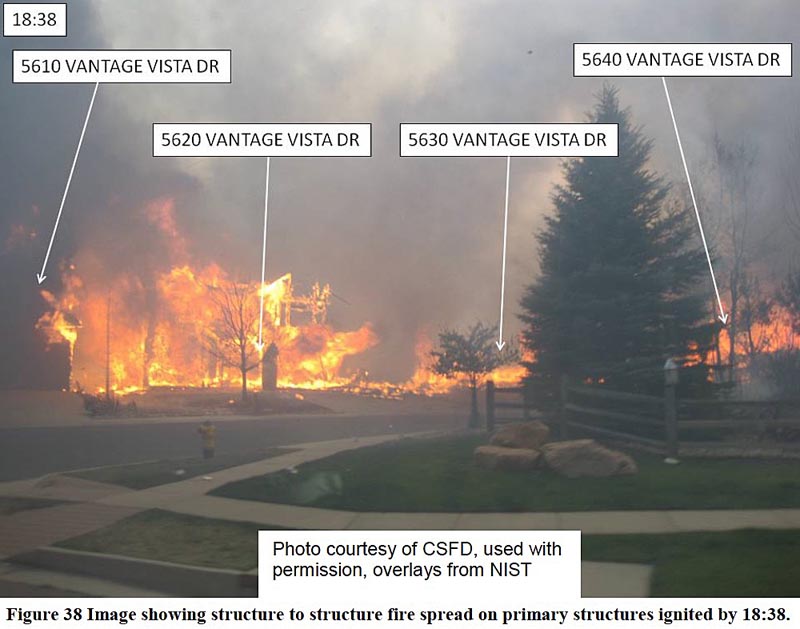
  • High-density structure-to-structure spacing in a community should be identified and considered in WUI fire response plans. In the Waldo Canyon fire, the majority of homes destroyed were ignited by fire and embers coming from other nearby residences already on fire. Based on this observation, the researchers concluded that structure spatial arrangements in a community must be a major consideration when planning for WUI fires.

Primary recommendations:

Continue reading “NIST releases report on Waldo Canyon Fire that burned 344 homes and killed two people”

White House announces efforts to mitigate effects of climate change on wildfires in urban interface

On Monday the White House announced several initiatives to mitigate the effects of climate change on fires in the wildland-urban interface (WUI). Vice President Biden appeared briefly at a meeting in the Executive Office Building with 20 fire chiefs and emergency managers from the western United States.

“I can’t prove any one fire is a consequence of climate change. But you don’t have to be a climatologist, you don’t have to be a nuclear engineer to understand that things have changed, they’ve changed rapidly,” the Vice President told the group. “The bottom line is your job is getting a hell of a lot more dangerous.”

At least 37 wildland fire chiefs and professional fire associations have signed on to a commitment, according to the White House, “to ensure that firefighters have the information, training and resources required to face the current and growing threats that climate impacts are having at the WUI, and to ensure community resilience by encouraging wildland fire prevention and mitigation practices by property owners, communities, and local governments across the country”.

The administration also announced the release of a study of the Waldo Canyon Fire that destroyed 344 homes in Colorado Springs in 2012, titled, A Case Study of a Community Affected by the Waldo Fire – Event Timeline and Defensive Actions (it can be downloaded here, but is a large file). The report covers firefighting tactics, how structures were ignited, defensible space, and how the fire spread, but oddly does not address to any significant extent the management, coordination, and cooperation between agencies, which was one of the largest issues. (We looked at this report in more detail in another article on Wildfire Today.)

Still another wildland fire related initiative announced Monday was the release of a report commissioned by the National Science and Technology Council, titled Wildland Fire Science and Technology Task Force Final Report. The task force was comprised of 28 representatives of federal agencies with any interest or responsibility, however fleeting, for land management or wildland fire.

The group’s primary recommendation was that a standing Federal Fire Science Coordination Council be established to:

  • ensure regular exchange among the leaders of those Federal organizations that either produce or use fire science;
  • strengthen coordination and collaboration among the organizations that produce wildland-fire science and technology;
  • establish mechanisms to systematically assess user needs and priorities for science, research, and technology support; and
  • define national-level needs for Federal fire science in support of the fire-management community

Fire shelter packaging has failed on two recent firefighter entrapments

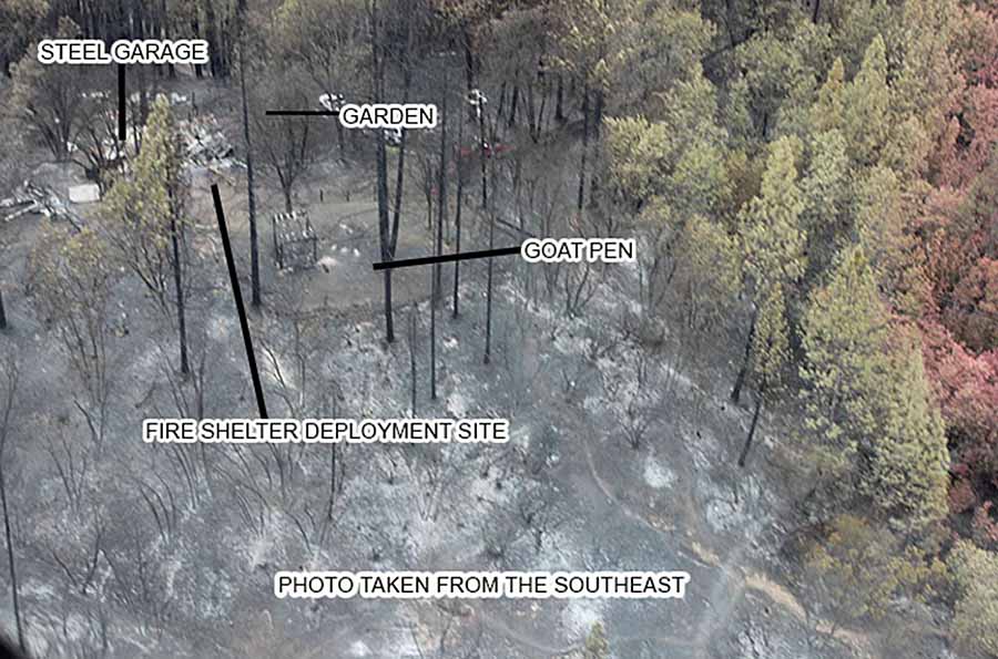
Valley fire entrapment site
Entrapment site of firefighters on the Valley Fire. Photo from the CAL FIRE report. (click to enlarge)

When two firefighters in California being overrun by flames on the Valley Fire in September of this year found that the plastic bag around their fire shelters had partially melted making it very difficult to deploy the life-saving device, it was not the first time this has happened.

A year earlier on the Beaver Fire in northern California two other firefighters experienced the same issue. The plastic became soft making it impossible for the tear strip to function. One of them used a knife to cut through the soft material that acted like “Saran Wrap”, and later said, “It wasn’t like the practice shelter at all”.

Four firefighters on the Valley Fire suffered significant burns to their heads, faces, arms, and hands before they were able to get into the shelters. The injuries on the Beaver Fire were less serious.

The Beaver Fire report addressed the failure of the fire shelter packaging:

Two of the firefighters who deployed reported that their shelter’s PVC bag became hot, which made it soft and pliable. This affected the ability of the red tear strip to pull apart.

But there was no recommendation that the design be modified.

The report on the 2015 Valley Fire entrapment describes a similar problem:

…FF4 had difficulty opening the fire shelter case from the Chainsaw Pack; the clear plastic covering of the fire shelter was soft and melted. FF4 had to remove the gloves to tear the plastic away from the aluminum shell of the fire shelter. FF3 couldn’t get the fire shelter out of the case because the clear plastic cover was melted to the white plastic protective sleeve…

One of the first times shelters were used was in 1964 when 36 members of the El Cariso Hotshots deployed them on a fire near Cajon Pass in southern California. Two years later 12 men on the crew were killed when they were entrapped on the Loop Fire on the Angeles National Forest — they were not carrying shelters at the time. In the hours before they began their fatal downhill fireline construction assignment the fire in that area had not been very active.

The U.S. Forest Service has modified the design of fire shelters several times since they were introduced in the 1960s. After 19 members of the Granite Mountain Hotshots were killed on the Yarnell Hill Fire in 2013 in spite of using the devices, the USFS began an effort to redesign them and has been testing numerous materials and configurations, including insulation that has been supplied by NASA.

The Press Democrat has a lengthy article about the recent deployments and the design of fire shelters.

…Firefighters across Sonoma County said they had been anxious to see the official preliminary Cal Fire “green sheet,” a summary of the incident released Oct. 3 detailing how the firefighters became injured [on the Valley Fire]. Many said they were stunned to learn about the plastic melting and the equipment failure on the survival tents they will all carry in the next wildland blaze even as the effectiveness of that equipment is under review.

Firefighters, especially those who jump into the thick of it, deal with extreme situations and the equipment must be able to withstand those situations, they said.

Ernie Loveless, who ran Cal Fire’s Sonoma-Lake-Napa unit for 20 years until he retired five years ago, said he was concerned about the durability of the bags after they were introduced in 2004.

“It seemed strange to have safety stuff like that made out of plastic that will melt in extreme heat,” said Loveless, who is now Schell-Vista fire board president. “I asked: ‘Why do we put stuff in plastic?’ The answer I received from our academy at the time is it was the best material they knew of at the time.”…

Thanks and a tip of the hat go out to Chris.

Was the 2014 wildfire season in California affected by climate change?

Happy Camp Complex, 2014
Happy Camp Complex in northern California in 2014. Photo by Kari Greer.

2014 was a busy year in California for wildland firefighters. Battles were fought over 555,044 acres of blackened ground in the state, which was the eighth largest number of acres burned in the last 28 years. So far in 2015, fires have covered 838,465 acres in California, which puts it fifth highest in 28 years.  (Stats from Cal FIRE and the NIFC National Situation Report.)

We have always been dubious of linkages between one weather event and long term climate change. When a senator brings a snowball onto the Senate floor or a governor talks about this summer’s fires to prove their cases that climate change does or does not exist, both may be over stating their “evidence”.

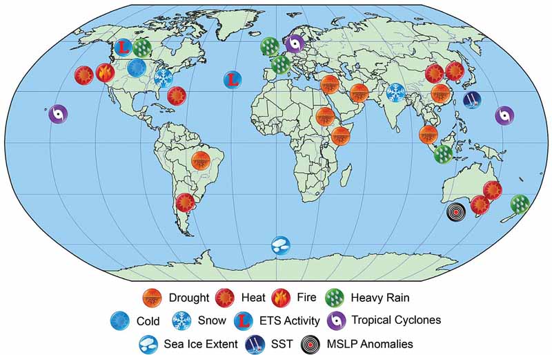
However, I’m not a meteorologist or climate scientist. But some of them who are, took a stab at investigating the possible attribution of extreme weather-related events in 2014 to global climate change. In their report, Explaining Extreme Events of 2014 from a Climate Perspective33 different research groups explored the causes of 29 different events that occurred that year.

The first event in the report is titled, Extreme Fire Season in California: A Glimpse Into the Future. It is debatable if the 2014 fire season in California was “extreme”, since like we wrote earlier, it had the eighth largest number of acres burned in the last 28 years according to data from the land management agencies. The authors, Jin-Ho Yoon, S.-Y. Simon Wang, Robert R. Gillies, Lawrence Hipps, Ben Kravitz, and Philip J. Rasch, reported “thousands more fires than the five-year average” between January 1 and September 20.

We don’t put very much stock in numbers of fires, since a small spot that can be stomped out by a couple of firefighters counts just as much as a 300,000-acre conflagration. Total burned acres is much more meaningful. The area burned data that the scientists studied was derived from satellite observations, which can underestimate wildfire extent due to its limit in the minimum detectable burned area, timing of the satellite overflights, light fuels cooling before being detected, and obscuration by cloud cover.

The report also examined the Keetch-Byram Drought index, and determined that “in terms of the KBDI and the extreme fire risk, 2014 ranks first in the entire state”, but it was not clear what time period they were referring to (it may have been since 1979).

The authors fall short of attributing the “extreme” 2014 fire season in California to global climate change:

Our result, based on the CESM1 outputs, indicates that man-made global warming is likely one of the causes that will exacerbate the areal extent and frequency of extreme fire risk, though the influence of internal climate variability on the 2014 and the future fire season is difficult to ascertain.

2014 climate events
Location and types of events analyzed in the publication. The image is from the study.

Only you…

Fire in the Lake San Antonio area of Monterey County, California, August, 2009. Photo by Vern Fisher.

The following article was contributed by Frank Carroll.

****

Only You…

For the United States Forest Service and the other major federal, state and local wildland fire agencies, the music is playing the band.  It worked OK for the Grateful Dead.  It’s a different story when it comes to developing and conducting wildland fire policy.

It may surprise no one to discover that wildland fires are bigger, more costly, more damaging, and more out of control than in any decade before the present, all the way back to 1910.  There was so much large fire on the ground in the 2015 fire season we ran out of superlatives to describe how big and bad they were.  In many cases the fires burned together forming “charismatic megafires” of untold destruction, sometimes because we had no choice.

Author Stephen Pyne, in an often brutally honest book about where we’ve been and where we’re headed with fire management in America, observes that fire is managing us; we’re not managing fire (Between Two Fires 2015).

What began in the late 1960s as a scarcely heard warning siren that wildfire should be left to its own devices on certain wild lands (prescribed natural fire or “let burn” fires pioneered by the National Park Service) became, by 2000, a five alarm screaming wail heard round the world.  Our best laid plans have come to naught.  We are caught in a blizzard of falling ash, awash in a river of flying embers, and blinded by the smoke.  It is clear that no human power will stop the rising tide of flames in wildlands and Red Zone suburbs where 10 percent of our homes are, no matter what the cost.

How we got here is a tale worth reading.  Where we’re headed is into the fog of war, but not without guideposts and markers.  Based on the very sound idea that fire should play a natural role in natural resource management, agencies and scientists spent the past 50 years trying to work out how to get it done.  And they had help.  The Nature Conservancy can field its own firefighters and burn its own ground.  Environmentalists looked for ways to burn without having to pay for the work of preparing and herding fires, and without the expertise to help.  Their grand experiment in the theology/ecology of hope over the last 50 years accelerated the fuels problem. The fuels situation is also exacerbated in places where logging results in activity fuels with resulting backlogs needing treatment and feeding wildfires.

Continue reading “Only you…”

Photo of Alder Fire used frequently in articles about wildfire

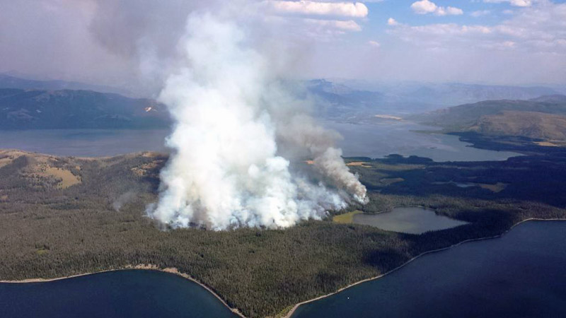
Alder Fire in Yellowstone National Park
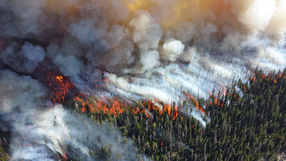
Alder Fire in Yellowstone National Park, August 19, 2015. NPS photo. (click to enlarge)

We happened to run across this photo of the Alder Fire in Yellowstone National Park when following up on a lead about how climate change may have influenced weather in 2014. After a few minutes of research we discovered that it was taken August 19, 2013 by fire personnel at Yellowstone National Park when they were monitoring the Alder Fire. It was burning at the same time two other fires were active in the park, the Alum and Druid Fires.

As we reported then, the Alder Fire was on a peninsula at the south end of Yellowstone Lake and eventually burned 4,240 acres. A lightning fire that was discovered on August 14, it was hemmed in by water on three sides and by a recently burned area to the south.

There are two reasons we are running the picture now — our Google research found that it has been used at least 228 times to illustrate various articles in the last two years; and, the picture is fascinating. The way the smoke is laying down on the lower-right side is very interesting, and a little mesmerizing, staying mostly below the tops of the trees. That smoke is apparently being sucked in to the area where the the intensity is greater and convection is developing, carrying the smoke vertically.

Below is another photo of the Alder Fire that we used in our 2013 article about the fires.

Alder Fire in Yellowstone National Park
Alder Fire in Yellowstone National Park, August 16, 2015. NPS photo.