Forests in many areas of California are just waiting for a spark

The Energy Release Component is at or above record levels in some areas of the state

Energy Release Component wildfire fire central sierra California
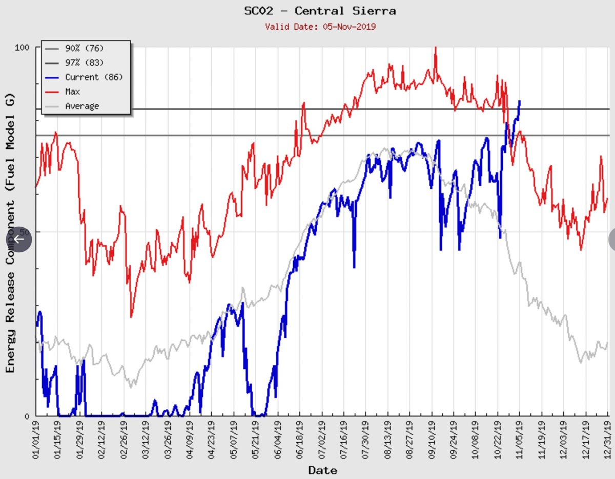
The Energy Release Component (or flammability) of the vegetation in the Central Sierra area is the highest recorded for this time of the year. (Click to enlarge)

The forests and brush lands of many areas of California are ready to burn. The effects of precipitation received in the winter and spring have been negated by relentless warm, dry, and occasionally very windy weather. The recent Kincade and Maria Fires were examples of wildfire potential during strong winds.

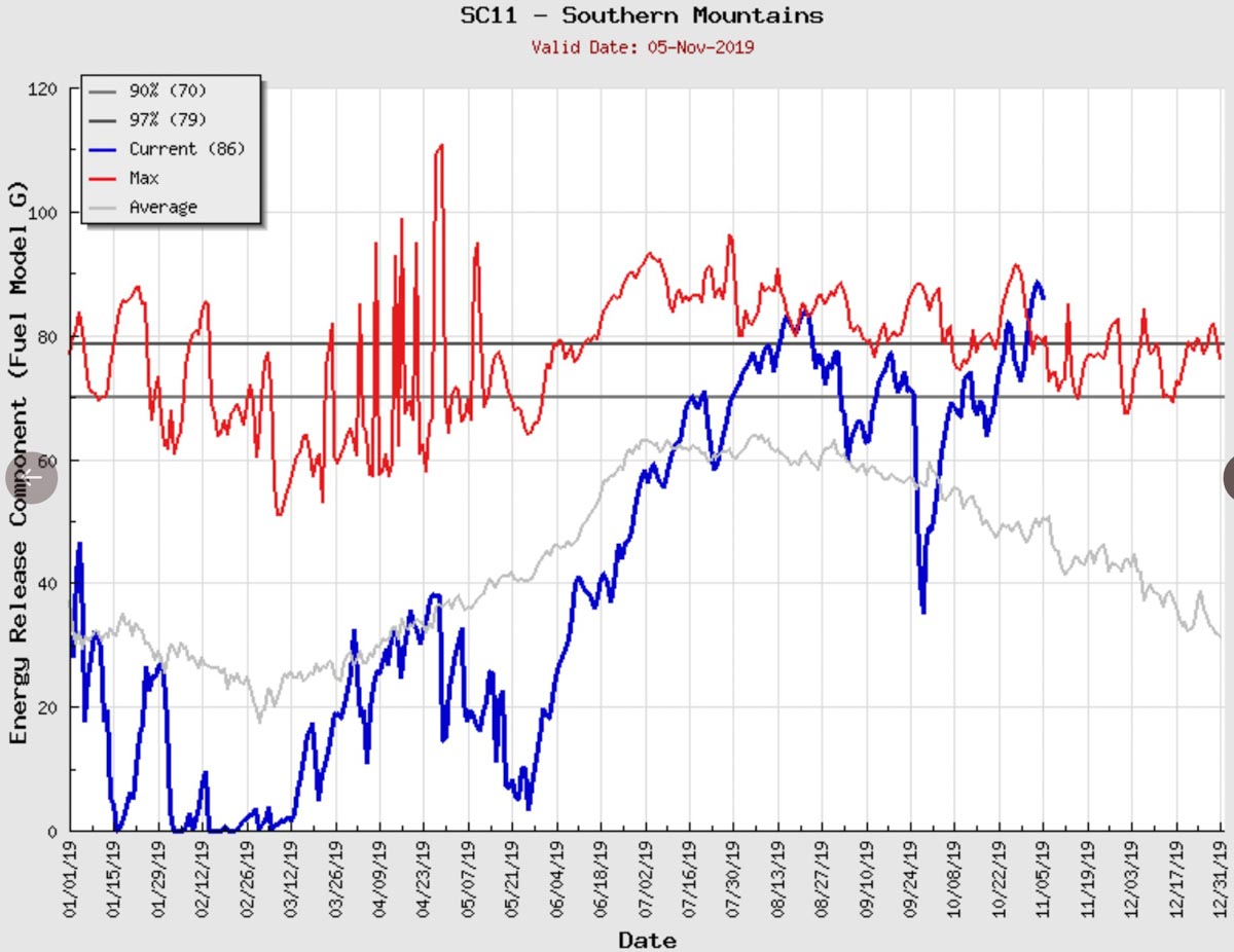
The Energy Release Component (ERC) is a measure of the heat produced within the flaming front of a vegetation fire and is largely influenced by the moisture in the live and dead fuels. In other words, it reflects the flammability of the vegetation. The weather in the last few months in California has resulted in many areas having record or nearly record high ERCs in recent days, including the Southern Mountains, Bay Marine, Central Coast, South Coast, Central Sierra, and Santa Cruz Mountains.

The data in these ERC charts shows the most current levels being above the 97th percentile for any date and close to or above the maximum ever recorded on November 5. (Charts for more areas in California)
Energy Release Component fire wildfire California mountains southern
The Energy Release Component (or flammability) of the vegetation in the Southern California Mountains is the highest ever recorded for this time of the year.

One thing that is striking about this information is the ERC in the Central Sierra, an area where the wildfire danger usually drops quickly after September. The conditions we are seeing now are similar to or perhaps more extreme than in 2017 and 2018 before the Camp, Woolsey, Thomas, and North Bay Fires that combined destroyed over 29,000 structures in October, November, and December.

This is not normal. The fire seasons are longer than they were a couple of decades ago.

The fuel is ready now. The only things lacking are very strong winds and an ignition source.
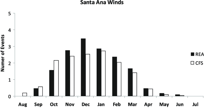
 Santa Ana wind events per month
The mean number of Santa Ana wind events per month. The dark bars refer to NCEP–DOE reanalysis and the clear bars refer to the CFS climate run. (Charles Jones, Leila M.V. Carvalho, and Francis M. Fujioka in Monthly Weather Review, December 2010)

There are no forecasts for very strong winds within the seven days in California, but wind is difficult to forecast and can sneak up on you. There is a possibility for an off-shore flow around November 15.

The three months with historically the most Santa Ana wind events are November, December, and January. The forecast for California in November is for higher than average temperatures and precipitation that is at or below average.
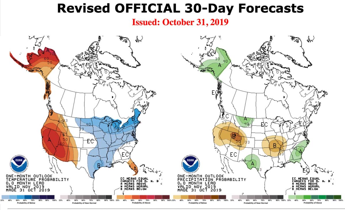
outlook probability precipitation temperature
One-month outlook for probability of precipitation and temperature, made Oct. 31, 2019, valid in November, 2019.

The Onion: Officials to reduce wildfire risk by shutting off oxygen to residents

And in what sounds like it is from The Onion, the CEO of PG&E gives advice about refilling refrigerators after they had to be emptied during power shutoffs.

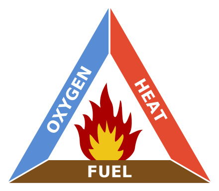
Fire Triangle
Fire Triangle

Satire from The Onion:


SAN FRANCISCO—With blazes engulfing Sonoma County and smoke-filled skies blanketing much of the Bay Area, officials in California announced Friday they would attempt to mitigate any further spread of wildfires with a mandatory shutoff of oxygen to thousands of the state’s residents. “In order to eliminate factors that could contribute to the fires’ growth, we will cut the flow of oxygen in high-risk areas throughout the northern part of the state,” California Public Utilities Commission president Marybel Batjer told reporters, explaining that the rolling “air-outs” would last 12 hours on average and residents would need to plan accordingly. “If each Californian can learn to make do without oxygen for just a day or two, we could avoid much of the devastation caused by wildfires. We understand this is a hardship, but it is simply too dangerous to allow open oxygen in fire-prone areas. Those requiring emergency supplies of air will be allowed to offset the shortage by cultivating hundreds of plants inside their home.” Batjer later confirmed that oxygen would continue flowing to all businesses deemed vital, including the headquarters of every major tech giant in or around Silicon Valley.


This satire is a takeoff on the fact that in recent weeks Pacific Gas & Electric and Southern California Edison cut power to millions of Californians over multiple days to prevent the companies’ dangerous and inadequately maintained infrastructure from starting more wildfires during strong winds. About 1,400 schools serving more than 490,000 students lost power for at least one day during power shut-offs between Oct. 24 and Nov. 1, according to Scott Roark, spokesperson for the California Department of Education.

Bill Johnson, the President and CEO of PG&E, did not win many friends during this October 31 exchange with Dan Noyes, a reporter for ABC7:

Noyes: “What do you say to people who just can’t afford to restock their fridges and are losing all this food they’ve had in their households after these shut offs?”

Johnson: “These events can be hard on people, really hard on people, particularly people who have struggles anyways and there are community-based things you can do, food banks, these kind of things. But for us, you know the main thing is we didn’t cause any fires, we didn’t, for these people we didn’t burn down any houses, the Kincade fire is still under investigation, I got that, but one of the things we did was give them the opportunity to actually refill their refrigerator ’cause their house is still there.”

The effects of shutting off the electricity rather than harden their infrastructure has far-reaching repercussions, including traffic lights not working, businesses having to close, difficulty in finding  functioning gas stations, air conditioning and heating unavailable, parents looking for child care when schools close, and many others.

Some cell phone systems do not have robust emergency power supplies, in fact some have none because the FCC does not require it. This can make the situation even worse for those without land lines who can’t call 911 for emergencies or receive evacuation notifications when endangered by a wildfire. It also makes it impossible for cell phones to receive earthquake warnings from the system that is being rolled out in California. In Marin County 57 percent of cell towers were down on October 28, for example.

Physical fitness test for wildland firefighters used in Alberta, Canada

This video shows the physical fitness test, WFX-FIT, used to evaluate wildland firefighters in Alberta, Canada.

The Pack Test version of the Work Capacity Test and the Step Test used by the Federal agencies in the United States basically measure how fast you can walk and how low you can keep your pulse rate, respectively. The Step Test was replaced by the Work Capacity Test.

The WFX-FIT used in some areas of Canada, which first saw widespread use in 2012, is described as “a valid job-related physical performance standard used to determine whether an individual possesses the physical capabilities necessary to meet the rigorous demands encountered while fighting wildland fires.” Here is a link to more information about the test.

Your thoughts on the WFX-FIT test?

The Ranch Fire burns hundreds of acres southwest of Red Bluff, Calif.

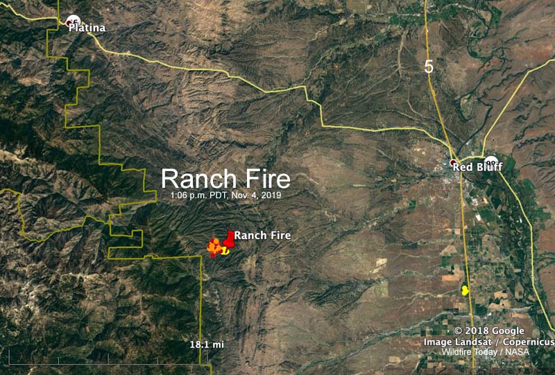
Ranch Fire map
Map showing heat detected by a satellite on the Ranch Fire at 1:06 p.m. PDT Nov. 4, 2019.

UPDATED at 6:42 p.m. PDT Nov. 4, 2019

CAL FIRE reported Monday at 6:25 p.m. that the Ranch Fire 21 miles southwest of Red Bluff, California has burned 1,308 acres. Early Monday morning it was 550 acres.

(To see all of the articles on Wildfire Today about the Ranch Fire, including the most recent, click here.)

The fire was very active Monday afternoon as firefighters on the ground were assisted by numerous air tankers and helicopters.

The fire was originally reported at Colyer Springs Road and Raglin Ridge Road in Tehama County.

The weather forecast for the fire area on Tuesday calls for moderate fire weather; 77 degrees, relative humidity of 20 percent, and winds from variable directions at 6 mph. Early in the morning the wind will be out of the northwest but will shift throughout the day, becoming southeast by sunset. Similar conditions are expected on Wednesday except the wind will be 6 to 10 mph out of the north after 9 a.m.

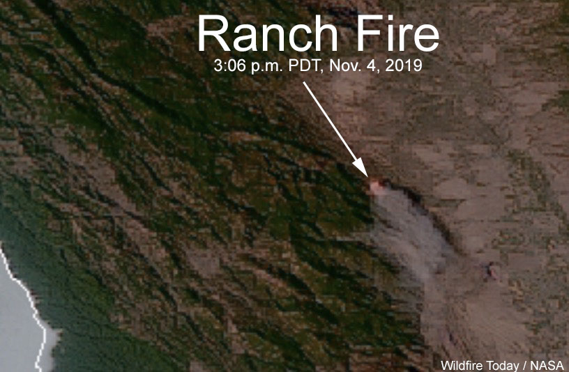
Ranch Fire map satellite photo
Sensors on the GOES-17 satellite detected heat and smoke from the Ranch Fire at 3:06 p.m. PDT Nov. 4, 2019.

Continue reading “The Ranch Fire burns hundreds of acres southwest of Red Bluff, Calif.”

The President again takes on fire and forest management in California

“The Governor of California, @GavinNewsom, has done a terrible job of forest management.”

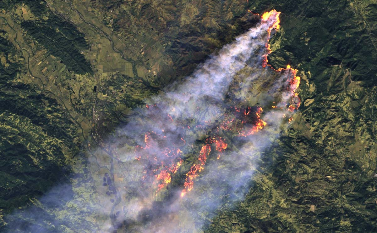
Kincade Fire photo Sentinel 2 satellite
Kincade Fire captured by the Sentinel 2 satellite at 12:02 p.m. PDT Oct. 27, 2019. Processed by Antonio Vecoli, @tonyveco.

Sunday morning President Trump renewed his verbal and tweet battle with the state of California and Governor Gavin Newsom in particular.

In a series of three tweets, Mr. Trump wrote:

The Governor of California, @GavinNewsom, has done a terrible job of forest management. I told him from the first day we met that he must “clean” his forest floors regardless of what his bosses, the environmentalists, DEMAND of him. Must also do burns and cut fire stoppers…..

..Every year, as the fire’s rage & California burns, it is the same thing-and then he comes to the Federal Government for $$$ help. No more. Get your act together Governor. You don’t see close to the level of burn in other states…But our teams are working well together in…..

….putting these massive, and many, fires out. Great firefighters! Also, open up the ridiculously closed water lanes coming down from the North. Don’t pour it out into the Pacific Ocean. Should be done immediately. California desperately needs water, and you can have it now!

After the Camp Fire wiped out much of Paradise, California Mr. Trump began criticizing forest management in the state and threatening to withhold federal funding.

On July 8, 2019 he said in a speech about the environment:

You can’t have dirty floors. You can’t have 20 years of leaves and fallen trees… And you don’t have to have any forest fires.

In November, 2018 the California Professional Firefighters responded to Mr. Trump’s criticism of forest management in the state:

The president’s assertion that California’s forest management policies are to blame for catastrophic wildfire is dangerously wrong. Wildfires are sparked and spread not only in forested areas but in populated areas and open fields fueled by parched vegetation, high winds, low humidity and geography. Moreover, nearly 60 percent of California forests are under federal management, and another one-third under private control. It is the federal government that has chosen to divert resources away from forest management, not California…

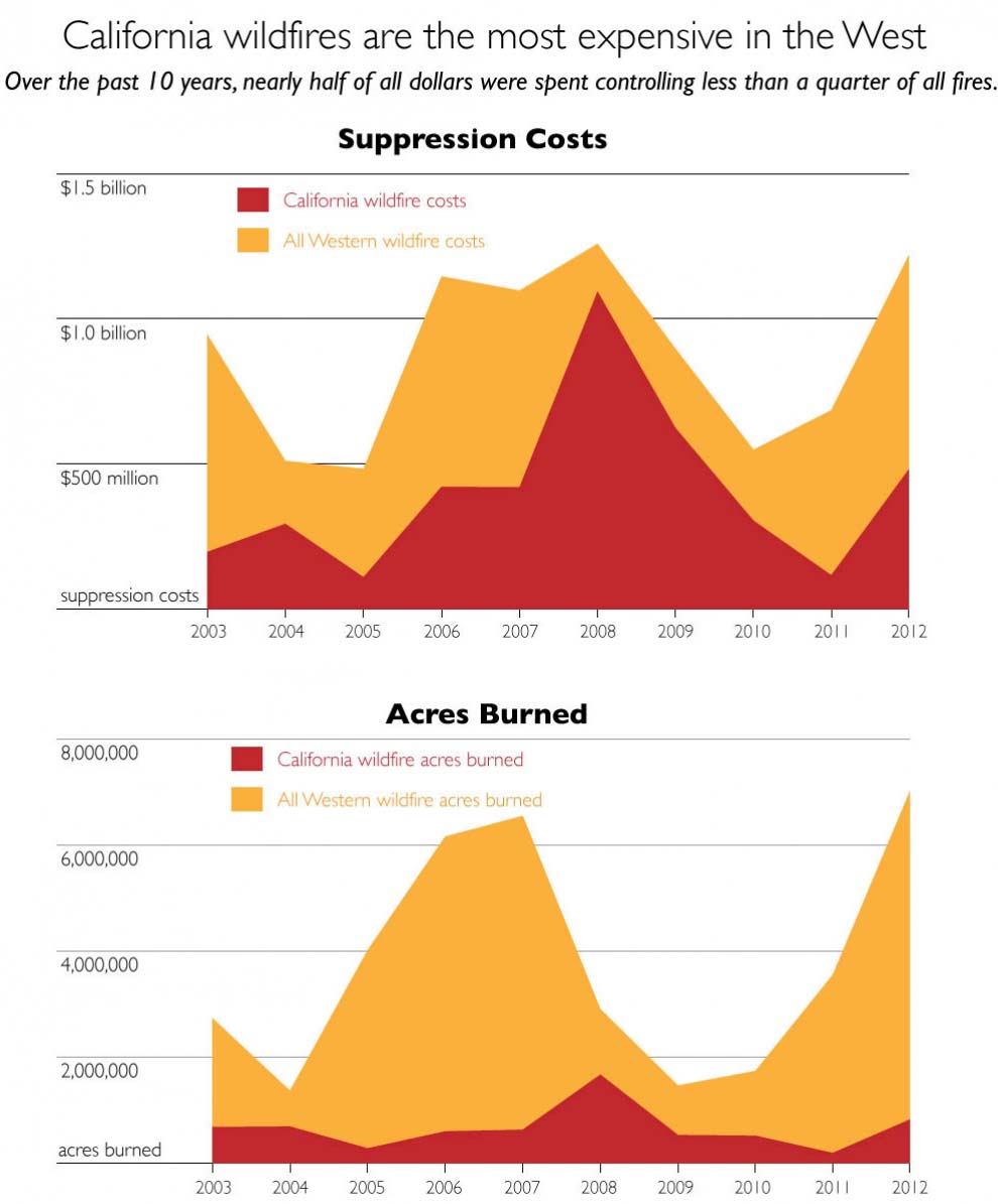
It is unclear what Mr. Trump meant when we wrote, “You don’t see close to the level of burn in other states.” Below are stats for fire suppression costs and acres burned in California vs. the 11 western states.

cost fires california
On average from 2003-2012, California wildfires had 44 percent of all reported suppression costs in the western 11 states (based on fiscal fire years, October 1 – September 30). Only 24 percent of acres burned were in California, on average, over the same time. Click image to enlarge. Credit: Climate Central.

(Note: if you would like to comment on this article by citing facts or expressing an opinion about wildfire and forest management in California, great, but please remember that at Wildfire Today we avoid political arguing, partisan stereotyping, and personal attacks. More information.)

Wrapping up the 77,000-acre Kincade Fire

The fire has burned 77,758 acres north of Santa Rosa, California

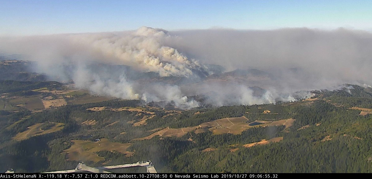
Kincade Fire 9:06 a.m. PDT Oct. 27, 2019
The Kincade Fire as seen from the St. Helena North camera at 9:06 a.m. PDT Oct. 27, 2019. Looking toward Healdsburg.

The Kincade Fire that raced across 77,758 acres north of Santa Rosa, California is not completely out and will not be for weeks or months, but there has not been any major spread for days. Satellites that can detect large areas of heat have not found any since November 1, but firefighters are still mopping up, extinguishing Black Oak stumps that the satellites can’t see, and are putting in fireline where needed. They will also need to repair miles of dozer line that helped keep the fire in check.

CAL FIRE reports that 175 homes, 11 commercial structures, and 186 other buildings have been destroyed.

All evacuation orders have been lifted except for three locations: Briggs Ranch Road area, Highway 128 North Knights Valley area to the Napa County Line, and The Chalk Hill Road area. (more information)

Resources assigned to the fire include 356 engines, 45 water tenders, 3 helicopters, 95 hand crews and 28 dozers for a total of 3,929 personnel.

The Press Democrat is not a huge media outlet, but the staff does a great job of covering wildfires in California’s North Bay. A November 1 article that summarizes the evolution of the Kincade Fire since it started on October 23 is evidence of why citizens should support local news and other original reporting. Their in-depth story has excellent photos and graphics as well as details you will not find other places.