Wildfires degrade public health across the country

South Moccasin Fire in Montana, October, 2021
South Moccasin Fire in Montana, October, 2021. Photo by Lauren Kokinda, BLM.

By Matt Vasilogambros 

As wildfires continue to burn in parts of the United States, state public health officials and experts are increasingly concerned about residents’ chronic exposure to toxin-filled smoke.

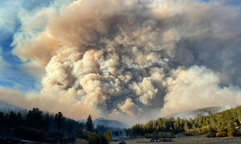
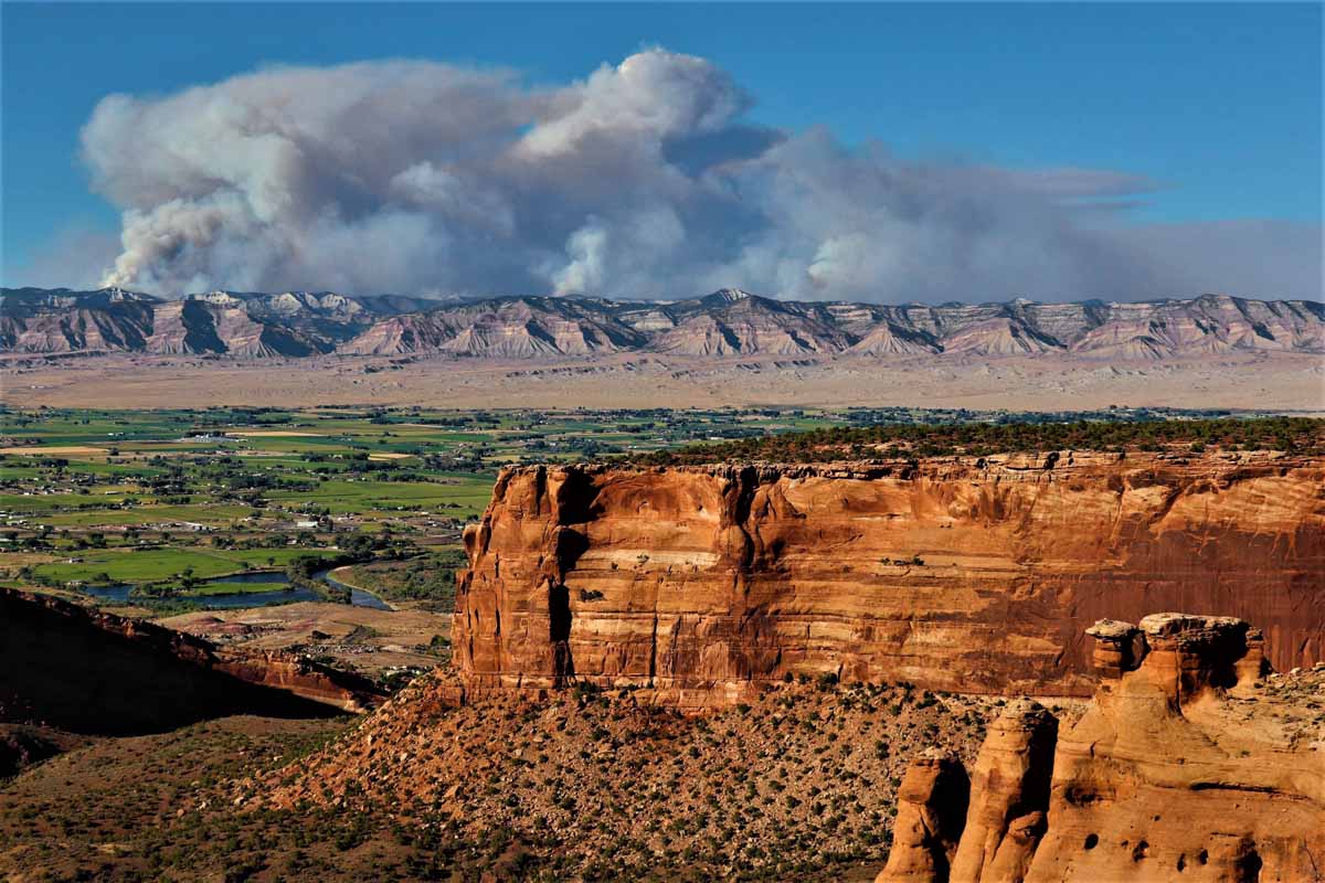
This year has seen the most wildfires of the past decade, with more than 56,000 fires burning nearly 7 million acres nationwide, according to the National Interagency Fire Center. While the total area burned is less than in some recent years, heavy smoke has still blanketed countless communities throughout the country.

Climate change is causing more frequent and severe wildfires, harming Americans’ health, pointed out Dr. Lisa Patel, deputy executive director at the Medical Society Consortium on Climate and Health, which raises awareness about the health effects of climate change.

“The data we have is very scary,” she said. “We are living through a natural experiment right now — we’ve never had fires this frequently.”

Patel sees the effects of wildfires in her work as a practicing pediatrician at Stanford Medicine Children’s Health, treating more women and underweight and premature infants at the neonatal intensive care unit when wildfires rage in Northern California.

As researchers focus on the public health impact of wildfire smoke, state health and environmental officials across the country have had to issue more air quality notices and provide guidance and shelter for residents struggling during periods of heavy wildfire smoke. And as experts have found, this issue isn’t isolated to the West Coast — it hurts more residents in the Eastern U.S.

Studies show that chronic exposure to wildfire smoke can cause asthma and pneumonia, and increase the risk for lung cancer, stroke, heart failure and sudden death. The very old and very young are most vulnerable. Particulates in wildfire smoke are 10 times as harmful to children’s respiratory health as other air pollutants, according to a study in Pediatrics last year.

What concerns experts is particulate matter in the air smaller than 2.5 microns across; there are around 25,000 microns in an inch. People inhale these microscopic bits, which then can embed deep in their lungs, irritating the lining and inflaming tissue. The particles are small enough to get into a person’s bloodstream, which can lead to other short- and long-term health effects.

Forecast for wildfire smoke
Forecast for wildfire smoke at 12:01 a.m. PDT Sept. 1, 2021.

Particulates in wildfire smoke are even hindering national progress on reducing air pollution, after decades of improvement.

The federal Clean Air Act has substantially decreased the level of toxic particles from industrial and automotive pollution across the country since 1970, the U.S. Environmental Protection Agency notes. But air pollution is expected to worsen in parts of the West because of wildfires, some researchers have found. A United Nations report earlier this year warned of a “global wildfire crisis,” saying the probability of catastrophic wildfires could increase 57% by the end of the century.

Researchers are trying to better understand how more frequent wildfires affect human biology.

Keith Bein, associate professional researcher at the University of California, Davis, created a rapid response mobile research unit in 2017 that he deploys when there are fires around the state. He’s like a storm chaser but for wildfires.

With his mobile unit, Bein can measure particulate matter in the air, take samples back to his lab and then determine their toxicology and chemical compositions. When near these fires, he said, the smoke is so bad that it feels like there’s no escaping it.

“The smoke rolls in, and you get that sinking feeling all over again,” he said.

Massive wildfires that tear through communities are becoming more common. The fires aren’t just burning trees but also synthetic materials in homes. And with repeated exposure to different particulates, health risks are more pronounced and can evolve into chronic conditions, Bein said.

Researchers are just beginning to understand how more frequent wildfires in residential areas impact human health, he added.

“It’s happening more frequently every summer,” he said. “The length of the fires is growing. The public exposure to the smoke is also growing. Once-in-a-lifetime events are happening every summer. This is a different kind of exposure.”

In 2020, a study in Environment International found that winter influenza seasons in Montana were four to five times worse after bad wildfire seasons, which typically last from July until September. The findings shocked study lead author Erin Landguth, an associate professor at the University of Montana.

“We know that hospitalizations for asthma and other respiratory conditions spike within days or weeks of wildfires,” she said. “The thought that this could potentially lead to effects later and how that can affect our immune system is really scary.”

Landguth is currently expanding her study to all Western states. She expects to find a similar trend throughout the Mountain West and Pacific Northwest. Monsoon season in Arizona and New Mexico may disrupt the trend there, she said, while air pollution is already so bad in California from smog and other pollutants that it might be difficult to pinpoint how wildfires are harming human health.

But wildfires are not just in the West, nor is their health impact geographically isolated. Some fires burn so intensely at such high temperatures that smoke rises into the atmosphere, where strong winds can carry the smoke long distances.

This was glaringly apparent in 2021 when the sun glowed red, and the sky hazed over New York City and throughout the Northeast, as smoke drifted from massive wildfires in California, Oregon and other Western states.

Pine Gulch Fire
Shot from Colorado National Monument August 7, 2020 about 15 miles Southwest of the Pine Gulch Fire. The view is looking towards the northeast and shows some of the explosive activity on the northern front Friday and the huge smoke plume extending to the east. Photo by Jennifer Deering.

That smoke is hurting the health of more people in the Eastern U.S. than it is in the West, said Katelyn O’Dell, a postdoctoral research scientist at George Washington University, who released that finding in a study in GeoHealth in 2021. Wildfire smoke contributed to more asthma-related deaths and hospital visits in Eastern communities than those in the West, she and other researchers found, in part because of higher population density.

The smoke hitting the Eastern U.S. doesn’t just come from the West; there are wildfires and prescribed burns throughout the country, said O’Dell.

“It’s sometimes easy to feel distant from fires and their impacts when you’re far from the flames of these large Western wildfires that are in the news,” she said. “But wildfires impact the health of the U.S.”

The next orange sunset people enjoy should be a moment to check an air quality mobile app, she said.

In Minnesota, the state has issued 46 air quality alerts since 2015, according to the state’s Pollution Control Agency. Of those, 34 were due to wildfire smoke, and 26 of those were issued last year.

That took state officials by surprise, said Kathy Norlien, a research scientist at the Minnesota Department of Health. The wildfire smoke risk is not just coming from the plumes that drift from the West Coast and Canada, but also from wildfires in the Boundary Waters — a lake-filled region in the northern stretches of the state. She expects the problem to worsen in the coming years.

“At this point, we’re planning for the worst-case scenario,” she said. “We have not had the extent that the Western states have had. But with climate change and concern over drought and the dry conditions, planning is of the utmost importance.”

She meets regularly with the Minnesota Pollution Control Agency and other state officials about how to get the message to state residents about the increasing wildfire risk to public health, encouraging residents to sign up for air quality alerts. State officials also have established larger community centers and buildings as safe air shelters.

The public plays an enormous role in both preventing (nearly 90% of wildfires are caused by humans, according to U.S. governmental data) and adapting to wildfires, many experts say.

For people living in fire-prone areas, there are nonflammable building materials for new homes and indoor air purifiers and upgraded HVAC systems. But these solutions may be too costly for some families, said Patel, of Stanford Medicine.

She counsels families about how to affordably stay safe during wildfire season, encouraging the use of N95 and KN95 masks, which were pivotal in combating the spread of the coronavirus. She also shares designs for do-it-yourself air filtration systems.

But she emphasized that wildfires will continue to rage across the country and cause adverse health effects unless climate change is reined in through serious public policy. Until then, climate change will continue to be the biggest threat to public health, she said.

“Summer used to be a time I’d look forward to,” she said, “but now I look at it with dread with the heat and wildfires.”


First published by Pew Charitable Trusts on Stateline. Used with permission.

More than 70 cars burn in grass parking lot near Temple, Texas

Robinson Family Farm Fire
Robinson Family Farm Fire. Lisa Adams.

The parking lot at the Robinson Family Farm in Temple, Texas turned into an inferno Saturday afternoon during their annual pumpkin patch event. According to the owner of the farm no injuries were reported but approximately 73 vehicles were destroyed when a wind-driven fire spread rapidly through the mowed pasture used as a parking lot.

Robinson Family Farm Fire
Robinson Family Farm. KCENN.

From KWTX:

The Temple Fire & Rescue Department responded to the blaze at around 1 p.m. Oct. 15. Multiple fire departments from Little River Academy, Troy, Rogers, Salado, Holland, Bartlett and Belton were called to assist.

The first units to arrive found approximately 10 cars on fire in the pasture area used for parking but due to the numbers of cars involved, the East Side Strike Team was called to bring in additional resources.

Fire crews were able to move some of the cars out of the way of the flames.

One attendee on Facebook wrote, “I have to say that is the most exciting and expensive pumpkin patch we’ve been to” after their family van “burned to a crisp.”

Robinson Family Farm Fire
Cars burn at Robinson Family Farm in Texas. KCENN.

On April 3, 2020 3,516 rental cars parked in a mowed field near the Southwest Florida International Airport (RSW) near Fort Myers, Florida burned in a similar manner.

“The cars were stored in a location not ordinarily used for any specific purpose”, Victoria B. Moreland, Director of Communications and Marketing for the airport said at the time. “The large number was due to the car rental agencies serving RSW not renting inventory during the peak season due to the current COVID-19 crisis.”

rental cars burn fire Fort Myers Airport
More than 3,500 rental cars burn at Southwest Florida International Airport at Fort Myers, Florida April 3, 2020. Fort Myers Fire Department photo.

At one point firefighters in Florida used dozers to build fireline through the cars to stop the spread.

Strong winds spread fires in Western Washington

4 p.m. PDT October 16, 2022

map Wildfires in western Washington, 3 p.m. PDT Oct. 16, 2022
Map of wildfires in western Washington, 3 p.m. PDT Oct. 16, 2022

Strong winds out of the east and southeast are increasing the spread of wildfires in Western Washington. Red Flag Warnings Sunday afternoon predicted 10 to 20 mph winds out of the southeast gusting at 25 to 30 with relative humidity in the low 20s.

Hilary Franz, the state’s Commissioner of Public Lands gave an update at about 2:20 p.m. Sunday:

Update Wash Fires

The Loch Katrine Fire on private land and the Mt. Baker-Snoqualmie National Forest 30 miles east of Seattle had burned about 2,000 acres at the last estimate Sunday afternoon. Aviation resources are being used where they can be effective. A Type 2 Incident Management Team will assume command on Monday.

map Smoke from wildfires in western Washington, 326 p.m. PDT Oct. 16, 2022
Smoke from wildfires in western Washington, 3:26 p.m. PDT Oct. 16, 2022.

Evacuations for approximately 1,000 homes are in effect at the Nakia Creek Fire 9 miles north of Washougal, Washington 11 miles northeast of Portland, Oregon. At 2 p.m. Sunday it had burned about 400 acres.

Lookout damaged in Bovee Fire to be assessed by engineer

Updated at 4:38 p.m. CDT October 16, 2022

Scott Lookout Tower, Nebraska National Forest
Scott Lookout Tower — Nebraska National Forest, Sept. 15, 2022. Photo by Rick.

We received photos taken by Rick of the Scott Lookout on the Nebraska National Forest that were taken September 15 about two weeks before the tower was damaged in the Bovee Fire on October 2. Rick is a Forest Service employee from another state and is knowledgeable about wildland fire.

Scott Lookout Tower, Nebraska National Forest. September 15, 2022.
Scott Lookout Tower — Nebraska National Forest, Sept. 15, 2022. Photo by Rick.

“The road up to the lookout was lined with big, old (well cured) hand piles and the tower was surrounded by ponderosa pines with an excellent needle cast duff layer,” Rick wrote.

Scott Lookout Tower, Nebraska National Forest
Scott Lookout Tower, Nebraska National Forest, Sept. 15, 2022. By Rick.

12:53 CDT October 15, 2022

Bovee Fire Scott lookout tower burning
Scott lookout tower burning during the Bovee Fire, October 2, 2022. USFS photo.

The Scott lookout tower that was damaged during the Bovee Fire in Nebraska on October 2 is going to be assessed next month by a structural engineer to determine the integrity of the structure that remains. The damage easily visible in photos includes wood steps and the cabin at the top. The steel framework still stands.

Bovee Fire Scott lookout tower
Scott lookout tower damaged during the Bovee Fire. USFS photo.

The fire burned nearly 19,000 acres of the Nebraska National Forest and private land on both sides of Highway 2 west of Halsey. When it started October 2 the relative humidity was in the 20s and the wind was gusting to 34 mph out of the south-southeast.

Bovee Fire Scott lookout tower
Scott lookout tower in the Bovee Fire. Photo by Nebraska State Patrol.

In addition to destroying most of the structures in a 4-H camp, several thousand acres of hand-planted forest burned. The forest was an experiment started in 1903 to provide timber for the railroad and early Sandhills residents. The first planting consisted of 35 acres of jack pine from Minnesota, 15 acres of yellow pine from the Black Hills, and 34 acres of mixed red cedar, blue spruce, jack, and yellow pine.

Bovee Fire grass
Grass sprouting after the Bovee Fire. USFS photo.

Washington Post article about six wildland firefighters

Fairview Fire, Sept. 7, 2022
Fairview Fire southeast of Hemet, CA, Sept. 7, 2022. By Ryan Grothe.

The Washington Post has published an interesting article about wildland fire. It was written by Amanda Monthei who had several seasons experience on hotshot crews. In recent years she has been busy writing about wildfire and climate adaptation for national publications.

In this case Amanda tells us about six former and current wildland firefighters from federal, tribal and private crews.

The excerpt below from the long article is about Jordin Schramm, a former rappeller and now an assistant engine captain for the US Forest Service in Oregon. The full article is here (subscription).

…Schramm knows a lot of women who work in the field, including four others who worked with her on her helirappel crew before she left to take a position as an assistant engine captain for the 2022 fire season. But as she nears 11 years of working in fire, there is one experience that she has found very few people can relate to: wanting to have children and stay on the line as a woman.

“I want kids, but I really don’t want to get out of fire,” Schramm said, suggesting that in wildland fire, that decision can feel like one or the other. “But it’s not one of those things where I’m going to stay in fire and have kids and be like, ‘I’ll show everybody.’ I want to stay and keep my qualifications because this is what I really like to do. But I’m not so naive to think that plan won’t change.”

[…]

“There’s nothing to complain about, but at the same time, maybe your expectations of your life have to change a little. And it’s hard to talk about this kind of stuff because there are only a couple of women who I know that are trying to stay in fire and have been able to make it work [with a family], while all my other female friends are like, ‘I don’t want kids.’ So I’m, like, ‘Okay, I can’t talk to you about this.’ Nobody ever really talks about this, which is understandable, because a lot of women [in fire] don’t want kids or don’t have kids. But at the same time, there’s a very small percentage of us that would like to have kids. And not having anybody to talk to in that situation is really difficult.”


You can follow Amanda on Twitter.


Photos of retardant dropped in Sespe Creek during Howard Fire

Map retardant Sespe Creek Howard Fire
Map showing location of photos of retardant near Sespe Creek at the Howard Fire. The red area is the western side of the fire Oct. 12, 2022. The photo locations were obtained from the metadata in the iPhone photos.

A lawsuit filed Tuesday alleged that the US Forest Service has polluted waterways by firefighting air tankers inadvertently dropping fire retardant in or near waterways in violation of the Clean Water Act and a policy adopted by the Forest Service and other federal agencies in 2011. The policy requires that retardant not be dropped within 300 feet of a waterway on federal land.

Retardant near Sespe Creek at the Howard Fire
Photo 1. Retardant near Sespe Creek at the Howard Fire. Oct. 12, 2022. Peter Deneen.

Fire Aviation has acquired photos and a video that reportedly show signs of retardant being dropped into Sespe Creek on the Los Padres National Forest 8 miles northeast of Ojai, California October 8, 2022. The photos were shot by Pete Deneen on October 12, 2022 at the 85-acre Howard Fire. The creek is designated a “wild and scenic river” and is in a wilderness area.

Retardant near Sespe Creek at the Howard Fire
Photo 2. Retardant near Sespe Creek at the Howard Fire. Oct. 12, 2022. Peter Deneen.

The photos show retardant on rocks and other objects very close to water in Sespe Creek.

Retardant near Sespe Creek at the Howard Fire
Photo 3. Retardant in a dry area of Sespe Creek at the Howard Fire. Oct. 12, 2022. Peter Deneen.

Some organisms, including aquatic threatened and endangered species or their habitats, can be adversely affected by retardants. In addition, retardant in water is a pollutant.

According to US Forest Service data, between 2012 and 2019, the Forest Service discharged retardant on at least 376 occasions totaling 761,282 gallons from aircraft directly into national forest waterways.

In the video below Mr. Deneen explains that there were two locations where retardant was dropped very close to the creek. In one case the aircraft may have turned as it was dropping to follow the creek for several hundred yards, or a second drop accounted for the retardant in the waterway.

The lawsuit was filed Oct. 11 by the Forest Service Employees for Environmental Ethics, FSEEE. In the group’s complaint they are seeking:

  • A declaration that the Forest Service’s placement of retardant in waterways is a violation of the Clean Water Act.
  • An injunction “to compel the Forest Service to comply with applicable environmental statutes, prevent irreparable harm, and satisfy the public interest.”
  • Reimbursement for FSEEE’s costs, expenses, expert witness fees, and attorney fees.
  • “Such further relief as may be just, proper, and equitable.”

More about FSEEE’s history of protesting retardant, and the federal government’s policy of retardant avoidance areas established in 2011.