Cave Fire near Santa Barbara burns thousands of acres, forcing evacuations

The fire started Monday afternoon, pushed by strong winds

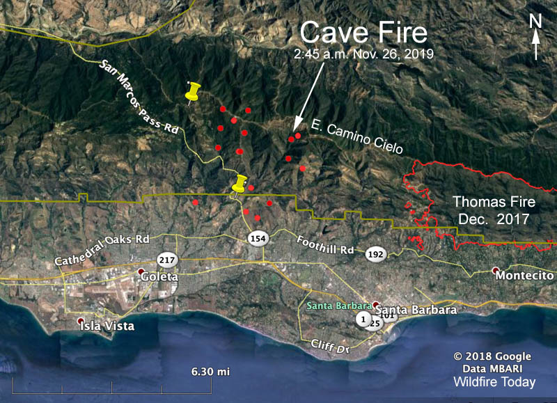
map Cave Fire Santa Barbara
The red dots represent heat on the Cave Fire detected by a satellite at 2:45 a.m. PST Nov. 26, 2019.

UPDATED at 1:55 p.m. PST November 26, 2019

At an 11 a.m. press conference Tuesday fire authorities said the Cave Fire at Santa Barbara, California had burned 4,262 acres. In addition to the 10 air tankers and 9 helicopters, 500 firefighters are working on the blaze.

The strong wind that drove the fire rapidly downhill toward the city Monday night slowed on Tuesday. Rain is expected to begin at about 10 p.m. Tuesday, but forecasters have backed off the two inches that was predicted through Thursday, cutting it in half, to about one inch. There is a chance of more rain this weekend.

(Click here to see all articles on the Cave Fire, including the most recent)


Updated at 8:01 a.m. PST Nov. 26, 2019

The spread of the Cave Fire northwest of Santa Barbara, California slowed after midnight Monday night but it continued to grow actively near Painted Cave Road and had burned into the San Marcos Foothills Nature Preserve just north of the city limits of Santa Barbara.

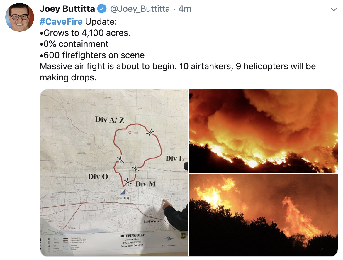
At 7:34 a.m. PST Mike Eliason of the Santa Barbara County Fire Department reported, “4,100 acres with 0% containment. 600 firefighters assigned. No structures (homes) destroyed & no injuries.”

In the map above the red dots represent heat detected by a satellite orbiting 500 miles above the earth. The locations have not been confirmed by individuals closer to the ground. We expect to obtain slightly more accurate satellite data later Tuesday morning.
map Cave Fire Santa Barbara
Posted by Joey Buttitta of Fox 11 at 7:38 a.m. Nov. 26, 2019.
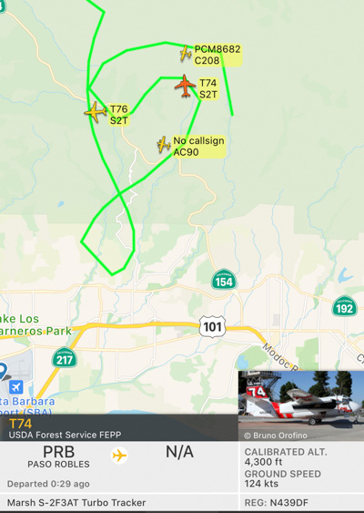
aircraft cave fire over
Aircraft over the fire at 7:52 a.m. included two S-2T airtankers and an air attack ship.
Cave Fire November 25, 2019
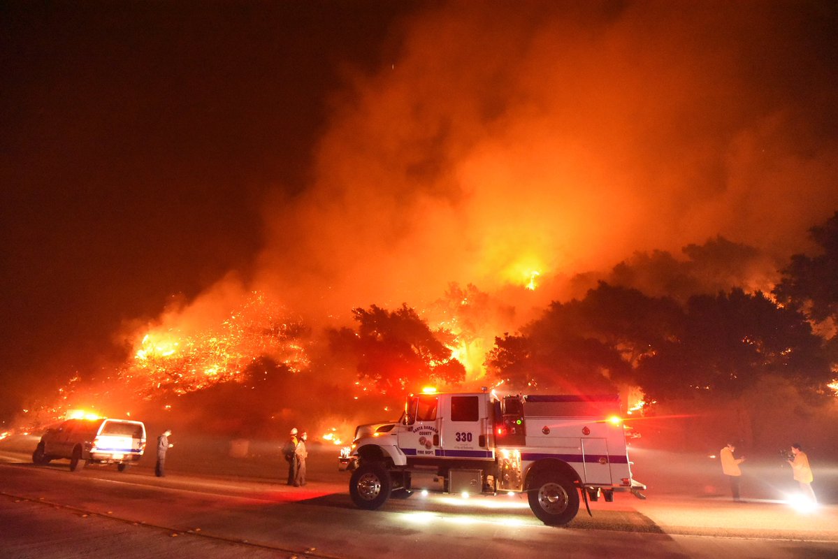
“#CaveFire- FF’s from Santa Barbara County Fire battle flames off CA Hwy-154 north of Santa Barbara Monday night,” wrote Mike Eliason of the Santa Barbara County FD who took this photo Monday night.

Originally published at 10:40 p.m. PST November 25, 2019

Firefighters are working to protect structures threatened by the Cave Fire that spread rapidly after it started northwest of Santa Barbara, California at 4 p.m. Monday. It was pushed by winds out of the north that increased from 5 mph to 16 mph, with gusts up to 30. At sunset a nearby weather station in San Marcos Pass recorded a temperature of 61 degrees with 16 percent relative humidity.

Continue reading “Cave Fire near Santa Barbara burns thousands of acres, forcing evacuations”

Red Flag Warning to be followed by snow in Owens Valley

It will also be very windy in Northern California

Red Flag Warning Sierras
Red Flag Warning issued at 1:57 a.m. PST Nov. 25, 2019. NWS.

8:24 a.m. PST November 25, 2019

Strong north winds gusting up to 50 mph in the Southern Sierras on Monday with humidity in the low teens has generated a Red Flag Warning for Owens Valley. The wind behind a cold front is expected to reach Bishop, California around 10 a.m. and then spread down to the rest of the valley by noon, continuing into the early evening before gusts decrease to less than 35 mph.

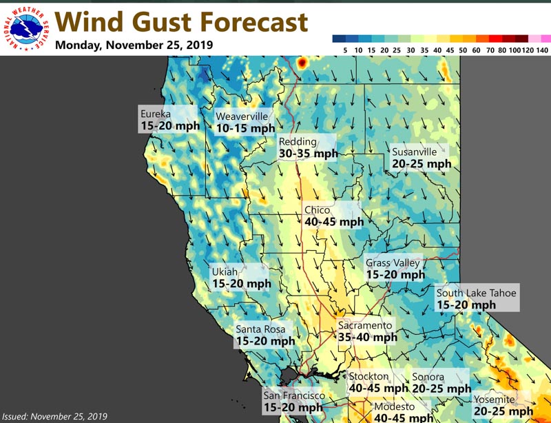
It will also be very windy in Northern California on Monday but no Red Flag Warnings have been issued for that part of the state as of 8:15 a.m. Monday.

strong wind forecast northern california

The enhanced wildfire danger will be followed by a winter storm warning from late Tuesday afternoon through Friday morning. Significant snow accumulations are predicted for much of Inyo County, the southern Great Basin, and higher elevations of the Mojave Desert. Forecasters expect total snow accumulations of five to 10 inches in the Owens Valley and 12 to 36 inches in the mountains, with winds gusting up to 45 mph.

(Red Flag Warnings can be modified throughout the day as NWS offices around the country update and revise their weather forecasts.)

Remnants of tropical storm pause fire season in Southern California

Nine weather stations in San Diego County recorded more than 4 inches of precipitation

Above: Mt. Laguna Observatory in Eastern San Diego County at 8 a.m. PST November 21, 2019. HPWREN.

On Tuesday the remnants of tropical storm Raymond hit Southern California and the next day merged with a cold storm that formed in the Gulf of Alaska. The result was two waves of rain, lightning, wind, and in the higher elevations, snow.

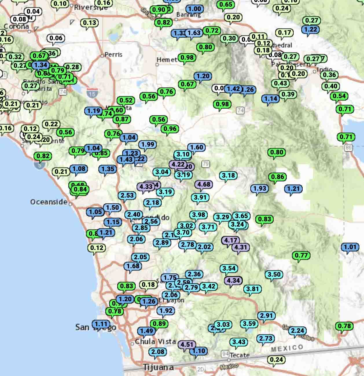
Nine weather stations in San Diego County recorded more than 4 inches of precipitation. The highest total was at Lake Henshaw with 4.68 inches. Some of the moisture became snow at Mount Laguna 6,100 feet above sea level.

Precipitation recorded Southern California
Highest totals of precipitation recorded in Southern California during the 48-hour time period ending at 8 a.m. PST Nov. 21, 2019. NWS.

Many other locations in San Diego County received more than an inch, but farther north Riverside, San Bernardino, and Los Angeles Counties had less.

This of course will pause the fire season in these areas and may be the season-ending weather event in the locations that were dumped on with multiple inches of precipitation.

Precipitation recorded Southern California
Precipitation recorded in Southern California during the 48-hour time period ending at 8 a.m. PST Nov. 21, 2019. NWS.

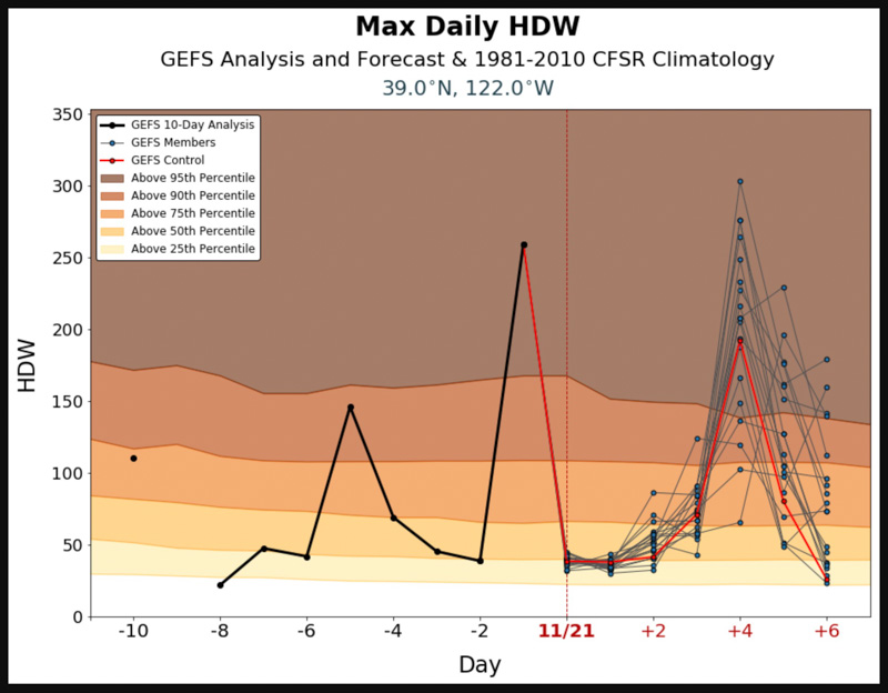
Meanwhile in Northern California it was dry and very windy Tuesday and Wednesday. On Monday in the Sacramento area the Hot Dry Windy Index is predicted to be above the 95th percentile again but there is a chance of rain in the area the next day, November 26.

Hot Dry Windy Index Sacramento weather wildfires
Hot Dry Windy Index for the area 25 miles west of Sacramento, CA. Generated November 21, 2019.

After the Tubbs Fire, homes in California town are being rebuilt without strong building codes

Above: Homes being rebuilt in the Coffey Park area of Santa Rosa. Screenshot from Sacramento Bee video.

In Santa Rosa, California the 1,200 homes that were destroyed in the 2017 Tubbs Fire are being rebuilt without a requirement that they adhere to the stricter building codes required in rural areas of California that would make them more resistant to being consumed in the next wildfire.

From the Sacramento Bee:

…Coffey Park [neighborhood] is rebuilding quickly: The community organization Coffey Strong says more than half of the 1,200 homes that burned down in 2017 are finished, and hundreds more are under construction.

But some wildfire experts wonder if Coffey Park isn’t courting danger by ignoring a state building code designed for wildfire-prone areas.

“They’re setting themselves up for the next disaster,” said Chris Dicus, a wildfire expert at Cal Poly San Luis Obispo. “I was disappointed to see they didn’t build up to code.”

Coffey Park residents seem resigned to the risk of another fire. They consider it part of the cost of living in a neighborhood they love. When asked about building codes, they say yes, another monster like the Tubbs Fire would be devastating — but no amount of fire-resistant roofing would likely change that.

“If it’s going to burn down, it’s going to burn down,” said Charlie Catlett, a retired physician who moved back home a little more than a week ago, after the latest evacuations were over.

Chapter 7A of the California Building Code designed for the state’s areas at high risk from wildfire can be optionally adopted by cities, but is mandatory in rural areas designated by CAL FIRE as being at high risk of wildfires. It lays out standards for roofs, exterior walls, vents in exterior walls and attics, windows, exterior doors, decking, and outbuildings.

Analysts studying the aftermath of the Camp Fire which destroyed much of Paradise, California found that homes built to fire-safe standards had a much higher survival rate than those that were not. Beginning in 2008 new construction in the city was required to follow Chapter 7A. Fifty-one percent of the homes built under that standard survived, while only eighteen percent built before 2008 did.

Headwaters Economics found that the cost of building a fire-resistant home is about the same as a standard home.

Adopting sensible building codes is very important, but a holistic approach is required to keep from repeating wildfire disasters:

  1. Home spacing/ lot size
  2. Envelope of the structure itself
  3. Home ignition zone
  4. Community infrastructure and planning
  5. Wildland-urban interface

In April, 2019, we covered these five categories in more detail.

Report released on the entrapment of firefighter and two civilians on Kincade Fire

The three people shared one fire shelter as the fire burned around them

The California Department of Forestry and Fire Protection, CAL FIRE, has released a Green Sheet, or preliminary report, on the October 25, 2019 entrapment of one firefighter and two civilians. It occurred on the Kincade fire northeast of Geyserville, California about 43 hours after the fire started.

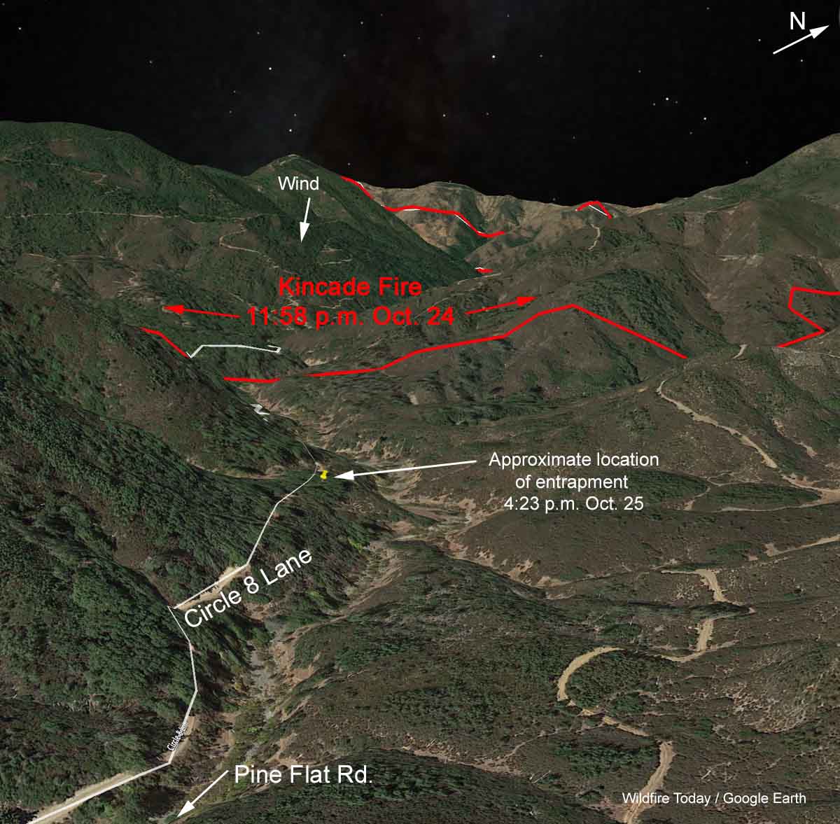
In mid-afternoon a Division Supervisor was scouting his division and searching for firefighters who he had been told were not wearing their Nomex wildland fire jackets. He turned his SUV off Pine Flat Road onto Circle 8 Lane, an unpaved road that reaches a dead end 1.5 air miles from Pine Flat Road.

map Kincade Fire entrapment deployment
3-D map showing the approximate location of the entrapment of three people on the Kincade Fire, October 25, 2019.

Later, seeing that the fire intensity had increased and crossed the road behind him, he realized that he was in imminent danger and decided to ride it out near an old cabin. A dozer operator had already cleared a line around the structure as as well as a line from the road downhill to the drainage.

Below is an excerpt from the Green Sheet as well as more maps, photos, and a video. The Division Supervisor is identified as “DIVS1”.

Continue reading “Report released on the entrapment of firefighter and two civilians on Kincade Fire”

Power company to pay $360 million to settle wildfire lawsuits

The settlement addresses costs after three fires in southern California started by electrical equipment burned 378,000 acres in 2017 and 2018 destroying over 2,600 structures

Above: 3-D map of the Thomas Fire, looking north. The red line was the perimeter at 12:30 a.m. PST December 17, 2017. 

Southern California Edison has reached an agreement to settle lawsuits with 23 public entities for taxpayer losses caused by wildfires attributed to the power company’s equipment. The settlement is related to damage and expenses incurred during and after three fires in 2017 and 2018, the Thomas Fire, Woolsey Fire, as well as the Koenigstein Fire which burned into the Thomas Fire. The agreement also addresses the debris flows that killed 20 people in Montecito when rains washed mud off the barren slopes of the Thomas Fire.

The $360 million settlement is for public entities only and does not affect the claims of residents, individuals, or businesses affected by the fires and debris flows.

“While this is not 100%, it’s not pennies on the dollar,” said John Fiske an attorney who represented local governments. “A lot of these communities … were hit very hard. In the aftermath of these wildfires, all sorts of public resources and taxpayer resources are lost.”

In December, 2017 the Thomas Fire burned over 281,000 acres and 1,000 homes in Ventura and Santa Barbara Counties in Southern California. The Woolsey Fire destroyed over 1,600 structures and burned nearly 97,000 acres north of Malibu, California in November, 2018.

The public entities involved in the agreement include Los Angeles County, Los Angeles County Flood Control District, Consolidated Fire Protection District of Los Angeles, Ventura County, Ventura County Watershed Protection, Ventura County Fire Protection District, City of Malibu, City of Agoura Hills, City of Calabasas, City of Hidden Hills, City of Thousand Oaks, City of Westlake Village, Conejo Recreation and Park District, Rancho Simi Recreation and Park District, Conejo Open Space Conservation Agency, Santa Barbara County, Santa Barbara County Flood Control and Water Conservation District, Santa Barbara County Fire Protection District, City of Santa Barbara, City of San Buenaventura, Montecito Water District, Montecito Fire Protection District, and Carpinteria Summerland Fire Protection District.