The state of California is beginning the initiative in rural San Diego County
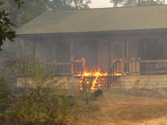
Relatively fire-resistant homes can ignite during low-intensity wildfires if a path of combustible material, such as fences, stairs, decks, or support beams lead the fire to the home. Image from Texas Forest Service report about fires in 2011.
Recognizing that the Home Ignition Zone can be the most important factor that determines how vulnerable a residence is to an approaching wildfire, the State of California has embarked on a pilot program that will grant up to $40,000 to homeowners who retrofit their homes to make them more fire resistant.
Working with the Federal Emergency Management Agency (FEMA) the funds in the $100-million project will be available in areas that are commonly threatened by fires.
The California Department of Forestry and Fire Protection, or CAL FIRE, chose the communities of Dulzura, Potrero and Campo based largely on their concentration of low-income residents living in older, fire-prone homes. The state is also starting to roll out the pilot in Shasta County [in Northern California]. Residents with higher incomes can still qualify for the retrofits as long as they pay for a percentage of the work on a sliding scale.
There may be additional federal funds becoming available in the future. During a January 21 speech at Del Rosa Fire Station on the San Bernardino National Forest Vice President Kamala Harris spoke about wildland fires and the resilience of communities threatened by fire.
“We are talking with home owners and reaching out to communities,” she said, “to figure out how we can support them to create a community that is less likely to be so significantly damaged if a fire should hit.”
However, she may have been referring to the $100-million from FEMA and California.
Our take
We will never be able to prevent all fires that threaten homes and private property. We have to learn to Live With Fire. The Home Ignition Zone should be an extremely high priority in preventing structures from burning in wildfires.
Grants for homeowners to retrofit homes to make them more fire resistant is the right thing to do. These could be expanded to include modifying the vegetation within 100 feet of the structures. Below is an excerpt from an article posted September 24, 2020 on Wildfire Today:
“Ignition resistant homes, and collectively communities, can be readily created by eliminating and reducing ignition vulnerabilities within the Home Ignition Zone,” said Jack Cohen, a retired U.S. Forest Service Research fire scientist. “This enables the prevention of wildland-urban fire disasters without necessarily controlling extreme wildfires. Ironically, ignition resistant homes and communities can facilitate appropriate ecological fire management using prescribed burning. The potential destruction of homes from escaped prescribed burns is arguably a principal obstacle for restoring fire as an appropriate ecological factor. Therefore, it is unlikely that ecologically significant prescribed burning at landscape scales will occur without ignition resistant homes and communities.”
Here are some suggestions that could be considered for funding along with an enhanced prescribed fire program.
Provide grants to homeowners that are in areas with high risk from wildland fires. Pay a portion of the costs of improvements or retrofits to structures and the nearby vegetation to make the property more fire resistant. This could include the cost of removing some of the trees in order to have the crowns at least 18 feet apart if they are within 30 feet of the structures — many homeowners can’t afford the cost of complete tree removal.
Cities and counties could establish systems and procedures for property owners to easily dispose of the vegetation and debris they remove.
Hire crews that can physically help property owners reduce the fuels near their homes when it would be difficult for them to do it themselves.
Provide grants to cities and counties to improve evacuation capability and planning, to create community safety zones for sheltering as a fire approaches, and to build or improve resilient emergency water supplies to be used by firefighters.
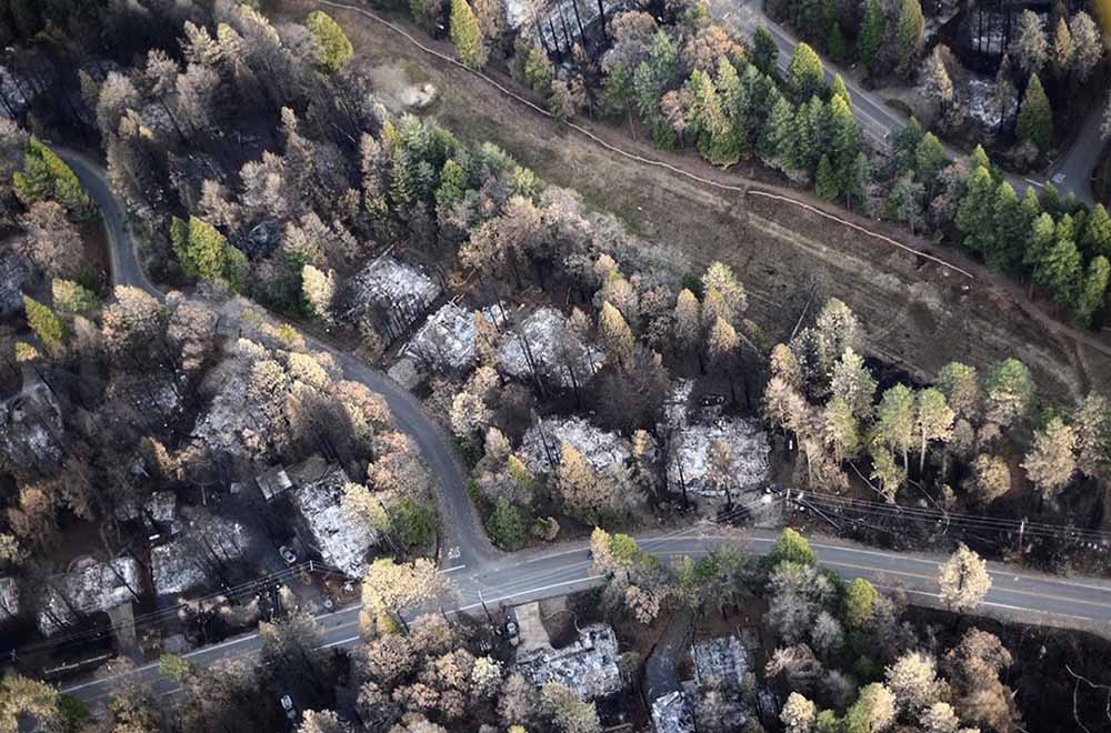
The blaze in Northern California destroyed 18,804 structures, most of which were in Paradise
Aerial image showing a portion of Magalia just NW of Paradise, illustrating a gradient of fire damage to overstory vegetation with distance from destroyed homes. At least in some areas, burning homes may have influenced the effects to overstory vegetation more so than burning overstory vegetation influenced the outcome to homes. Photo: Owen Bettis, Deer Creek Resources.
In a paper published October 4, 2021, researchers analyzed the structures that were destroyed and those that survived the Camp Fire that ran through the city of Paradise, California in 2018. They considered at least four primary characteristics of structures:
Were they built before or after the adoption in 2008 of Chapter 7A of the California Building Code which requires certain fire resistance measures, including exterior construction materials used for roof coverings, vents, exterior walls, and decks and applies to new construction of residential and commercial buildings in designated fire hazard severity zones.
Distance to nearest destroyed structure.
Number of structures destroyed within 100 meters.
Pre-fire overstory tree canopy within 100 meters
They found that the last three criteria were the strongest predictors of survival. Homes more than 18 meters from a destroyed structure and with less than 53 percent pre-fire overstory canopy within 30 to 100 meters survived at a substantially higher rate than homes in closer proximity to a destroyed structure or in areas with higher pre-fire overstory canopy. Most fire damage to surviving homes appeared to result from radiant heat from nearby burning structures or flame impingement from the ignition of near-home combustible materials. The researchers concluded that building and vegetation modifications are possible that would substantially improve outcomes. Among those include improvements to windows and siding in closest proximity to neighboring structures, treatment of wildland fuels, and eliminating near-home combustibles, especially within 1.5 meters of the structure.
The authors noted that while 7a includes requirements not found in many building codes, a few others are more complete incorporating multiple construction classes based on anticipated radiant heat, flame, and ember exposure levels. For example Chapter 7A does not consider the interaction between components such as siding, window, and the under-eave area on an exterior wall.
There is an opportunity for much needed improvement in both current building codes and how we live in wildfire prone WUI areas.
Below is the complete Conclusion section from the research.
Conclusions
The results of this study support the idea that both proximities to neighboring burning structures and surrounding vegetation influence home survival with wildfire. Denser developments, built to the highest standards, may protect subdivisions against direct flame impingement of a vegetation fire, but density becomes a detriment once buildings ignite and burn.
Recent examples of losses in areas of higher density housing include the wind-driven 2017 Tubbs Fire in northern California, where house-to-house spread resulted in the loss of over 1400 homes in the Coffey Park neighborhood (Keeley and Syphard 2019), and the wind-driven 2020 Almeda Fire in southern Oregon, which destroyed nearly 2800 structures, many in denser areas in the towns of Talent and Phoenix (Cohen and Strohmaier 2020). Once fire becomes an urban conflagration, proximity to nearby burned structures becomes especially important because occupied structures contain significant quantities of fuel, produce substantial heat when burned, and are a source of additional embers. For density to be protective, home and other structure ignitions would need to be rare.
Fifty-six percent of homes in Paradise built during or after 2008 did not survive, illustrating that much improvement is needed in both current building codes and how we live in wildfire prone WUI areas before proximity to nearby structures becomes a benefit rather than a vulnerability. The threat posed by nearby burning structures as well as our finding of an apparent strong influence of vegetation 30–100 m from the home—a distance that in most cases encompasses multiple adjacent properties—demonstrates that neighbors need to work together to improve the overall ability of homes and communities to resist wildfire exposures.
To maximize survivability, homes need to be designed and maintained to minimize the chance of a direct flame contact, resist ember ignition, and survive extended radiant heat exposure. Our analyses demonstrating the strong influence of nearby burning structures on home survival suggests improvements to resist radiant heat exposures may be warranted in the California Building Code—i.e., increasing the standards for buildings within a certain minimum distance of other structures.
Some possible improvements might include noncombustible siding with rating minimums tied to proximity to other structures, both panes in windows consisting of tempered glass, or installation of deployable non-combustible shutter systems. Additionally, certain options for complying with Chapter 7A are better for resisting radiant heat and flame contact exposures and could minimize fire spread to other components. Whereas the International Code Council’s Wildland Urban Interface Building Code (International Code Council 2017) provides three ignition-resistant construction classes to allow for material restrictions as a function of exposure level, Chapter 7A consists of one level, so is binary in nature in that a building either needs to comply, or it does not. The Australian building code for construction in bushfire prone areas, AS 3959 (Standards Australia 2018), incorporates six different construction classes based on anticipated radiant heat, flame, and ember exposure levels. Interaction between components, for example, siding, window, and the under-eave area on an exterior wall, is not considered.
Our summary of damaged but not destroyed homes in Paradise was in line with other reports showing a high proportion of home ignitions indirectly resulting from embers (Mell et al. 2010). Embers frequently ignited near home combustibles such as woody mulch, fences, and receptive vegetative fuels with flames and/or associated radiant heat then impacting the home itself, supporting awareness of the importance of combustibles within the first 1.5 m (5 ft) of the building on home survival.
A re-interpretation of defensible space fuel modifications is needed to increase the building’s resistance and exposure to embers and direct flame contact, especially in the area immediately around a building and under any attached deck or steps. This does not diminish the value of defensible space fuel modifications 9 to 30 m (30 to 100 ft) away from the home, which not only reduces fuel continuity and the probability of direct flame contact to the home, but also provides firefighters a chance to intervene.
While our data show a relationship between home loss and vegetative fuels (high pre-fire overstory canopy cover likely associated with a greater litter and woody fuel abundance, as well as other wildland understory vegetation) that can contribute to fire intensity and ember generation, the WUI fire loss issue has been described as home ignition problem more so than a wildland fire problem (Cohen 2000; Calkin et al. 2014). The damaged home data were in line with this view, with few homes showing evidence of continuity with wildland fuels that would contribute to flame impingement, but numerous homes with near home fuels, both from manmade and natural sources, that led to direct or indirect ember ignitions.
California’s Mediterranean climate will continue to challenge its residents with regular wildfire exposure throughout the state. Whether through modifying the nearby surface and vegetative wildland fuels or the home itself, adapting to wildfire will take time. The good news is that the trend in survival is improving with newer construction practices. However, with 56% of houses built after 2008 still succumbing to the Camp Fire, much room for improvement remains.
Our data suggest it is possible to build (and maintain) buildings that have a high probability of surviving a worst-case scenario type of wildfire, even in fire-prone landscapes such as the Paradise area. Newer homes built after 1972, where the nearest burning structure was >18 m away, and fuels associated with vegetation 30–100 m from the home kept at moderate and lower levels (<53% canopy cover) had a 61% survival rate—an approximately 5-fold improvement over the Paradise housing population as a whole. Survival percentages substantially higher still are potentially possible if all components of risk, including ember generation in nearby wildland fuels, continuity of wildland and other fuels on the property, and home ignitability are sufficiently mitigated.
Citation:
Knapp, E.E., Valachovic, Y.S., Quarles, S.L. et al. Housing arrangement and vegetation factors associated with single-family home survival in the 2018 Camp Fire, California. fire ecol 17, 25 (2021). https://doi.org/10.1186/s42408-021-00117-0
Fuel treatments, Lake Tahoe area, and perimeter of the Caldor Fire Sept. 1, 2021.
For decades land managers and some residents in the Lake Tahoe area have been anticipating the Caldor Fire that has been burning since August 14. The blaze has blackened more than 204,000 acres as it rages to the northeast. It passed through the south edge of Meyers six miles south of the lakeshore and the head of the fire Wednesday morning was four miles from the lake.
Under the concept of reducing the fire threat to structures in the Lake Tahoe Basin, the US Forest Service and other organizations have been conducting hazardous fuel treatments. Since 1997, over 2,000 acres of landscape underburns and over 8,000 acres of prescribed pile burning has been completed on the Lake Tahoe Basin Management Unit (LTBMU), a division of the USFS that manages much of the land near the lake. In these areas, surface fuels have been reduced and smaller live trees thinned. The USFS says this “creates a zone where a damaging crown fire is less likely, which provides a safer environment for firefighters.”
The map above shows the fire on the morning of September 1 and completed hazardous fuel treatments. The green areas represent mechanical methods, such as thinning by hand or by using machines such as dozers or feller bunchers which can rapidly gather and cut a tree before felling it. Then the cut vegetation is piled. The purple areas represent locations where piles were burned. Some of the projects shown were completed in the last few years and others are older. This map shows very few areas (in yellow) that were treated with prescribed broadcast fire.
The USFS web page for the LTBMU politely says that budget restraints limit the number of acres that can be treated: “Increasing the annual number of acres treated with prescribed fire will challenge our future capacity.”
USFS engine crews on the initial attack of the Caldor Fire, August 14, 2021. USFS photo.
The hope is that reducing the flammable vegetation will reduce the chances of structures being destroyed when a fire like the Caldor Fire burns into the area. Thinning trees and removing brush will not stop a fire, but in a best case scenario under benign weather and fuel conditions it might reduce the intensity of the fire and the number of firebrands landing on and near structures. If a fire does dramatically slow down when entering a treated area, it may make it possible for firefighters on the ground, perhaps aided by firefighters in the air, to stop the spread. That is, unless the wind is too strong and the vegetation moisture is historically low like we have seen this summer in California. As we wrote on August 22, under these conditions, “There is no possibility of stopping the forward spread of the fire. There is no number of 747 air tankers or firefighters on the ground that could be effective against the flaming front of this raging inferno.” This will continue to be true until something changes — some combination of cooler more humid weather, less wind, and vegetation with higher moisture content — or until it runs out of fuel at high elevations or spreads into agricultural land.
The Caldor has been lofting burning embers into the air that have landed a mile ahead of the flaming front, starting new fires, called spot fires by firefighters. When that is occurring fuel reduction projects a half mile wide around a community will not necessarily keep structures from burning. We could pave the forest paradise and put up a parking lot but if a fire a mile away can ignite residences we need other solutions.
The Home Ignition Zone (HIZ) is what home owners need to concentrate on. If it is welcoming to an ember storm, then the structure could burn no matter how much forest management is done. The HIZ must be maintained so that burning embers will not start a fire on the structure or ignite nearby vegetation which creates a fire that spreads to and ignites the building.
This is called Living With Fire. We can’t stop fires from burning, but we can stop homes from igniting when the inevitable fire occurs.
The best way to prevent homes from being destroyed in a wildfire is not clear cutting or prescribed burning a forest, it is the homeowner reducing flammable material in the HIZ. This includes spacing the crowns of trees at least 18 feet apart. The envelope of the structure itself must be fire resistant, including the roof, vents, siding, doors, windows, foundation, fences, eaves, and decks. A FEMA publication (13 MB) has excellent detailed recommendations. Headwaters Economics found that the cost of building a fire-resistant home is about the same as a standard home. When implemented, Chapter 7A of the California Building Code, regulates these features.
Here is an excerpt from an article written by Jack Cohen and Dave Strohmaier:
Uncontrollable extreme wildfires are inevitable; however, by reducing home ignition potential within the Home Ignition Zone we can create ignition resistant homes and communities. Thus, community wildfire risk should be defined as a home ignition problem, not a wildfire control problem. Unfortunately, protecting communities from wildfire by reducing home ignition potential runs counter to established orthodoxy.
UPDATE September 3, 2021:
In a live briefing Sept. 3 about the Caldor Fire near South Lake Tahoe, California, East Side Incident Commander Rocky Oplinger complimented the land owners and managers for the fuel treatments that have been accomplished over the years. He said the 150-foot flame lengths dropped to about 15-feet when the fire entered the treated areas. This allowed hand crews and engines to take an aggressive approach to suppress the fire and prevent structure loss. The video of the briefing is on Facebook; Mr. Oplinger’s comments about the fuel treatments begin at 34:10.
The Federal Emergency Management Agency has recently awarded millions of dollars through their Disaster Mitigation Grant program.
Boulder County, Colorado
Boulder County will receive a $1.2 million Pre-Disaster Mitigation Grant for two wildfire mitigation actions. The first is to create defensible space for approximately 500 properties. The second is hazardous fuels reduction in an area of about 160 acres that will provide further protection on 27 properties where defensible space creation was previously completed.
Homeowner efforts to create defensible space will not just be a one-time effort. They will join the county’s wildfire mitigation program, Wildfire Partners, to support continued maintenance of defensible space over the long-term and conduct comprehensive mitigation efforts to effectively reduce wildfire risk in a community that has been severely affected by wildfire.
FEMA is providing 75 percent of the project costs, a total of $1,215,630. Funding is provided through FEMA’s Pre-Disaster Mitigation Grant Program, which is designed to assist states, U.S. territories, federally-recognized tribes, and local communities in implementing a sustained pre-disaster natural hazard mitigation program. The goal is to reduce overall risk to the population and structures from future hazard events, while also reducing reliance on federal funding in future disasters.
Ashland, Oregon
The city of Ashland, Oregon will receive a $3 million Pre-Disaster Mitigation Grant to create wildfire defensible space around 1,100 homes and to replace 23 wood shake roofs with ignition-resistant roof material.
The City of Ashland in Oregon’s Jackson County is in a high wildfire risk zone. In the fall of 2020, neighboring communities of Talent and Phoenix were devastated by the Almeda Fire, which burned 2,977 acres and destroyed over 2,300 structures.
This mitigation project will help protect structures from wildfires and will help homes in the Ashland area comply with recommended local best practices for wildfire risk reduction. Replacing wood shake roofs and providing defensible space to structures reduces the risk of wildfire spread and diminishes the likelihood of wildfires starting from embers. Once these highly flammable roofs are replaced, these types of roofs will no longer be allowed in Ashland.
The City is contributing a $1 million cost-share, making the total value of this grant $4 million.
The project includes hiring a project manager, preliminary assessments of identified homes, surveys for vegetation removal, scheduling and training of pre-approved contractors, removal of vegetation, and reconstruction of roofs.
Rolling Hills, California
A $1.1 million grant is going to the Los Angeles community of Rolling Hills. The funds will replace overhead power lines and poles with nearly 2,000 feet of underground cables and relocate transformers to an area with less wildfire risk. The Los Angeles Fire Department identified the area as a Very High Fire Hazard Severity Zone, the highest designation with the greatest fire risk.
The $1.5 million project includes a $1.1 million grant from FEMA’s Hazard Mitigation Grant Program (HMGP), with the remaining $381,000 from non-federal sources.
Our take
As we wrote last September, grants to mitigate wildfire risk and improve community resiliency is a worthwhile investment:
Provide grants to homeowners that are in areas with high risk from wildland fires. Pay a portion of the costs of improvements or retrofits to structures and the nearby vegetation to make the property more fire resistant. This could include the cost of removing some of the trees in order to have the crowns at least 18 feet apart if they are within 30 feet of the structures — many homeowners can’t afford the cost of complete tree removal.
But the limited amount of Federal taxpayer funds available must be distributed where they can get the most bang for the buck and assist a significant number of residents.
Rolling Hills is a gated community of private roads on a hill overlooking the Pacific Ocean in Los Angeles where the median household income is $239,375 and the poverty rate is 1.6%. The project will reduce wildfire ignitions along 2,000 feet of power lines.
Boulder County has a median household income of $83,019 and a poverty rate of 10.7%. Their grant will mitigate hazards on 527 properties.
Ashland, Oregan has a median income of $56,315 and a poverty rate of 18.4%. More than 1,100 homes will be affected by the project.
Putting 2,000 feet of power lines underground in Rolling Hills could reduce the chance of poorly designed or maintained electrical lines starting fires. But a case could be made that the project should not rank high enough nationwide to prevent other grants from being approved that would have a much greater beneficial effect on larger numbers of people with far less disposable income. In this affluent Los Angeles community improvements on the electrical lines, in this case, should be funded by the Los Angeles Department of Water and Power.
There is probably more than one resident in Rolling Hills who could write a check for the project then go into the backyard and finish their game of tennis.
Sponsored by two Senators and four Representatives
154th Company, Civilian Conservation Corps, Eagle Lake Camp NP-1-Me. Bar harbor Maine, February, 1940.
Two Oregon Senators are going to reintroduce a bill that would put people to work in the woods, helping to restore public lands and provide jobs. The 21st Century Conservation Corps Act brought forward by Senators Ron Wyden and Jeff Merkley, would provide funds to support a natural resource management and conservation workforce and bolster wildfire prevention and preparedness.
Of course an earlier Conservation Corps with some similar goals was the Civilian Conservation Corps (CCC) 80 years ago. (More about the CCC later in this article.)
According to Senator Wyden:
Rural communities are facing two big challenges: struggling economies and continued wildfire threats. By investing in a 21st century workforce, this bill will put people to work to tackle the climate emergency, restore our public lands and reduce wildfire risks. The bottom line, creating new jobs and supporting our public lands go hand in hand.
Provisions
Some of the provisions in the legislation would actually accomplish some meaningful things out on the ground that could make a difference:
Establishes a $9 billion fund for qualified land and conservation corps to increase job training and hiring specifically for jobs in the woods, helping to restore public lands and provide jobs in a time of need.
Provides an additional $3.5 billion for the U.S. Forest Service and $2 billion for the U.S. Bureau of Land Management to support science-based projects aimed at improving forest health and reducing the risk of catastrophic wildfire.
Establishes a $2 billion fund to provide economic relief for outfitters and guides holding U.S. Forest Service and U.S. Department of the Interior special use permits.
Provides $2 billion for the National Fire Capacity program, which helps the Forest Service implement FireWise, to prevent, mitigate, and respond to wildfire around homes and businesses on private land.
Provides $6 billion for U.S. Forest Service, $6 billion for the National Park Service, and $2 billion for the Bureau of Land Management maintenance accounts to create jobs, reduce the maintenance backlog, and expand access to recreation.
Provides $3.5 billion for reforestation projects on a combination of federal, state, local, tribal and NGO lands, with over one hundred million trees to be planted in urban areas across America by 2030.
Increases access to public lands through expanding and investing in programs like Every Kid Outdoors and the Outdoor Recreation Legacy Partnership.
Legislation with the same title was first introduced in the 2017-2018 Congress by Senator John McCain with strong bipartisan support, and a second time in the 2019-2020 Congress by Senator Ron Wyden. Neither was brought to a vote in the full Senate. It is possible that with the new administration and a new Congress the bill will have a slightly better chance of passage. So far, all six of the co-sponsors are of the same party, Democratic.
National Prescribed Fire Act of 2020
A few of the provisions in the bill are similar to our recommendations made in the analysis of the National Prescribed Fire Act of 2020, Senate Bill 4625, which was introduced September 17, 2020 by Senator Ron Wyden and died in the last Congress. It would have helped address the workforce capacity issue by appropriating $300 million for both the Forest Service and the Department of the Interior to plan, prepare, and conduct controlled burns on federal, state, and private lands.
At the time I made some suggestions that could be considered for funding along with an enhanced prescribed fire program:
Provide grants to homeowners that are in areas with high risk from wildland fires. Pay a portion of the costs of improvements or retrofits to structures and the nearby vegetation to make the property more fire resistant. This could include the cost of removing some of the trees in order to have the crowns at least 18 feet apart if they are within 30 feet of the structures — many homeowners can’t afford the cost of complete tree removal.
Cities and counties could establish systems and procedures for property owners to easily dispose of the vegetation and debris they remove.
Hire crews that can physically help property owners reduce the fuels near their homes when it would be difficult for them to do it themselves.
Provide grants to cities and counties to improve evacuation capability and planning, to create community safety zones for sheltering as a fire approaches, and to build or improve emergency water supplies to be used by firefighters.
The 21st Century Conservation Corps has some of the same goals as the Civilian Conservation Corps which between 1933 and 1942 employed young men across the United States who had trouble finding employment during the Great Depression. Through the course of its nine years in operation, three million participated in the CCC, which provided them with shelter, clothing, and food, together with a monthly wage that is equivalent to about $600 today. Enrollment peaked at the end of 1935, when there were 500,000 men in 2,600 camps with operations in every state.
The program closed in 1942 with World War II raging. The military reluctantly helped run the program but when the draft began in 1940, the policy was to make CCC alumni corporals and sergeants. Through the CCC, the regular army could assess the leadership performance of both regular and reserve officers.
Many of the projects the CCC accomplished still exist today. Their work included:
Structural improvements: bridges, fire lookout towers, service buildings;
Transportation: truck trails, minor roads, foot trails and airfields;
Erosion control: check dams, terracing, and vegetable covering;
Reports can be customized for every city, county, and state
Homes at risk from wildfire in Yreka, CA. An excerpt from a report by Headquarters Economics.
Headwaters Economics has developed new Wildfire Risk report system for communities. Reports can be customized for every U.S. city, county, and state which provide information about wildfire risk and potentially vulnerable populations. It uses public data from the USDA Forest Service, US Census Bureau, and other sources and is one of several reports available in their Economic Profile System.
Headwaters Economics explains that they created this new report because wildfire risk is more than a physical hazard. Economic, demographic, and social vulnerabilities put some people disproportionately at risk. Information in their reports can help elected officials, land use planners, fire personnel, and community health organizations to:
prioritize and direct resources to the people and places most at-risk;
customize and target outreach and education efforts; and
tailor wildfire response and operational plans.
The graphic at the top of this article is a portion of the 15-page report for Yreka, California, which can be downloaded here.
Arizona Central also has a system for generating data about wildfire risk for individual communities in the Western United States.