After assessing the exposure to wildfire of communities across the Pacific Northwest Region, Oregon and Washington, the 50 most-threatened communities in each state were identified.
In the broadest sense, wildfire exposure encompasses the likelihood of wildfire burning a given location on the landscape, and the potential intensity of a wildfire if one were to occur. For this assessment the researchers focused only on wildfire likelihood because the effect of fire intensity on home loss rate is not well studied, and because the inclusion of intensity for this and similar assessments did not influence the conclusions. Wildfire likelihood is measured by annual burn probability, a measure generated by comprehensive simulation of wildfire occurrence and spread (see section below on Wildfire hazard simulations).
The 10 communities in Washington with greatest cumulative housing-unit exposure to wildfire. The “mean of exposed housing units” rank indicates the mean (typical) burn probability of housing units within each community.The 10 communities in Oregon with greatest cumulative housing-unit exposure to wildfire. The “mean of exposed housing units” rank indicates the mean (typical) burn probability of housing units within each community.
The research was commissioned by the U.S. Forest Service’s Northwest Region.
More details, including lists of the 50 most threatened communities in both Oregon and Washington, can be found here.
Two decades of work in Montecito, California had a positive effect during the fire
The northern edge of Montecito, CA shares a five-mile border with the Los Padres National Forest. Looking north. Google Earth/Wildfire Today. Click to enlarge.
In December, 2017 the Thomas Fire burned over 281,000 acres and 1,000 homes in Ventura and Santa Barbara Counties in Southern California. But in Montecito, with a wildland-urban interface stretching for five miles along the Los Padres National Forest boundary, only seven primary residences were destroyed. Considered a success story, this result is due to many factors, including the fact that homeowners and firefighters had days to prepare for the fire entering the city, which meant that firefighters did not have to make a choice between helping residents to evacuate or protecting homes. This is in stark contrast to last November’s Camp Fire that raced into Paradise, California within a couple of hours after being ignited by a PG&E power line. In that case firefighters did not have the luxury of suppressing the fire as it burned homes; they had to concentrate on helping residents evacuate and saving lives.
But another important factor that helped to reduce the number of homes destroyed in Montecito in 2017 was the pre-fire mitigation work that had been ongoing in the community for two decades.
After the fire the Montecito Fire Protection District sought to document and understand the confluence of social, ecological, and biophysical factors associated with implementing fire adaptation activities and how they affected the outcome of the Thomas Fire in their community.
The findings in this study should be considered by all communities in a fire-prone environment. Cities that resist mitigation efforts such as constructing fuel breaks, enacting FireWise building codes, spacing homes more than 10 to 20 feet apart, planning for evacuations, and being proactive in protecting their residents long before smoke is in the air, are doomed to a very unpleasant and rude awakening one day. It is not IF a fire will impact their community, it is WHEN.
The Montecito Community Wildfire Protection Plan used fire modeling to geospatially characterize ember exposure and defensibility across the community with respect to structures, in order to prioritize key areas for future vulnerability reduction activities. (From the report)
…Here, we document both the social and the biophysical vulnerability reduction strategies taken by the community of Montecito, California in Santa Barbara County, USA, prior to the 2017 Thomas Fire, and how those strategies translated into outcomes. Montecito is one of the many communities in the United States that has been repeatedly exposed to wildfires over the last several decades, with multiple disastrous events . As such, the Montecito Fire Protection District (MFPD) embarked on an effort to reduce wildfire vulnerability in the community two decades ago. That effort was subsequently tested in the December 2017 Thomas Fire, which consumed over 1000 homes and became the largest wildfire in contemporary California history for several months until it was surpassed in 2018. Most of the homes were consumed at the outset of the Thomas Fire on days when strong downslope winds (i.e., Santa Ana and Sundowner winds) prevailed, and extreme fire behavior including long runs and long-range spotting, occurred, overwhelming fire suppression efforts. By contrast, Montecito experienced relatively little infrastructure damage from the Thomas Fire, despite similar conditions, including extreme fire behavior and the presence of Sundowner winds on the day the fire beset the community (16 December 2018).
Montecito Fire Protection District fuel treatment network, homeowner defensible space, and locations of residences (both primary homes and guest houses) destroyed by the Thomas Fire in Montecito.
Over the 20-year period between 1999 and 2018, the MFPD expended approximately $1.76 million (mill) USD ($2 mill USD adjusted for inflation to 2018) on wildfire vulnerability reduction activities (Figure 2). We include 2018 here as these are fiscal year totals, where the fiscal year ends June 30 of the year listed, so the Fiscal Year 2018 (FY2018) expenditures were primarily expended in autumn 2017, prior to the December ignition of the Thomas Fire (this also contributes to reduced FY2018 expenditures relative to prior years). When adjusted for inflation, it is clear that funding was inter-annually variable, but generally increasing over time (Figure 2).
Most of the activities undertaken by MFPD addressed more than one component of the vulnerability triangle (i.e., exposure, sensitivity, and adaptive capacity).
Any action that specifically identified geospatial patterns of exposure to wildfire (e.g., defensible space surveys), or was designed to reduce direct exposure to wildfire (e.g., defensible space improvements, roadside fuel reduction) addressed exposure vulnerability.
Any action that specifically identified populations in the community that are more sensitive to the negative ramifications of wildfire and determined population-specific actions designed to mitigate those ramifications addressed sensitivity vulnerability.
Any action that increased the ability of the community to respond to wildfire and reduce the negative ramifications developed adaptive capacity.
An action such as hiring a Wildland Fire Specialist, whose primary position is to build relationships with community members and facilitate programs to reduce vulnerability, addressed all three components of vulnerability.
Evacuation and ingress/egress issues were key elements of two other activities undertaken by MFPD prior to 2017.
First, MFPD improved ingress/egress and evacuation and fire suppression effectiveness by delineating pre-attack zones across the community in their wildland fire initial attack plan. MFPD utilized these pre-attack zones (which are essentially sub-units of the community that were delineated prior to firefighters attacking a future, hypothetical wildfire) in their community education efforts, planning process, and printed high-resolution paper maps of each zone that were pre-packed in a portable file box for distribution to non-MFPD fire suppression resources in the event of a wildfire. Nine of the interviewees noted the utility of these maps in facilitating greater life safety for firefighters and increased suppression effectiveness, because the maps were able to help resources not familiar with the area to navigate the community safely and quickly and find the pre-designated water sources and equipment staging areas in Montecito, which were also marked on the map.
Second, while MFPD implemented several new fire codes focused specifically on structures (e.g., banning cedar shakes for roofing and siding, requiring boxed eaves), a new requirement for wider driveways focused on reducing exposure through improved evacuation, and increasing adaptive capacity by facilitating firefighter safety during fire suppression activities and post-fire clean up. In Montecito, as in many WUI communities, many of the homes are located at the end of long (>100 m), narrow, winding driveways that terminate at garages. Increasing driveway width and turnaround space supports larger fire apparatus and other large equipment allowed firefighters access these areas, and safely use a tactic referred to as “fire following.” Fire following is frequently used during extreme conditions, wherein firefighters (1) prepare homes to resist an oncoming wildfire, (2) retreat from the home or neighborhood when extreme fire behavior and direct flames from the fire front threaten their life safety, and then (3) “follow” behind the flaming front and re-engage with the home or in the neighborhood. During this re-engagement, they focus on extinguishing portions of the structure that are on fire, extinguishing spot fires on the property, remove flaming debris from structures (e.g., flaming palm fronds on the roof or deck), and wetting down vegetation if there are additional threats for re-ignition (e.g., additional spot fires). Fire following depends on firefighters being able to safely navigate to a home and turn around so that they can evacuate rapidly if needed; driveway design is paramount to this dependency.
The effectiveness of fire suppression efforts was directly supported by the pre-fire vulnerability reduction efforts undertaken by MFPD. Interviewees noted that they were able to use fire following tactics because homes were fire-resistant, giving firefighters time to engage and remove flammable debris before a structure became fully involved with fire. Firefighters also described being able to engage because most homes had sufficient defensible space to make it safe for them to do so, without fear of entrapment. This was of particular concern due to entrapment of firefighters that occurred on the nearby Jesusita Fire in 2009, which was associated with lack of defensible space and evacuation routes.
Interviewees also noted that suppression effectiveness was amplified by the reduction of roadside fuels, which allowed them to conduct backfiring operations along some parts of the road system and hold the fire along other segments. Interviewees described the difference between other portions of the Thomas Fire in Santa Barbara County, where heavy roadside vegetation created a “tunnel effect” that inhibited large fire apparatus passage (leading to over a dozen homes destroyed in one nearby canyon), and Montecito, where roadside clearance eliminated vegetation tunnels and facilitated two large city fire apparatus being able to pass each other on narrow roads. Videos taken by some interviewees further demonstrated how such clearance improved firefighter safety given the low visibility created by heavy smoke. Several firefighter fatalities in the US have been attributed to exiting the roadway due to lack of visibility in smoky conditions.
Both defensible space and roadside fuel treatments were supplemented by the community fuel treatments implemented by MFPD, which served to “link” together with the fuel reductions undertaken by residents and along roadways. All but one interviewee described this network of fuels reduction as being vital to effective suppression efforts and structure protection, specifically because it allowed firefighters to engage the fire safely. Of the seven primary residences destroyed in Montecito, two were located below a ‘gap’ in the fuel treatment network, and the loss of the remaining dwellings was primarily attributed to the presence of fuels immediately adjacent to the structure, and inaccessibility for firefighters to support the fire following tactic. These losses were attributed to fire exposure that was not mitigated.
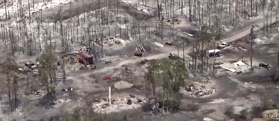
Structures that burned in the Puntzi Fire in British Columbia.
A reporter asked me what needs to be done to keep from repeating disasters like we have seen recently in California at Paradise, Redding, and the Napa Valley. I told him that there is no one thing that needs to be done, such as raking or “forest management”, it requires a comprehensive holistic approach.
The principle of the weakest link in the chain applies here. If one of the categories of improvements to protect a development is sub-par, the individual structures and the entire community in a fire-prone environment is at risk. And if a homeowner does not do their part, it can endanger their neighbors.
Reducing the chances that a fire in a populated area will turn into a disaster that burns thousands of homes involves at least six categories of factors: home spacing, envelope of the structure itself, home ignition zone, community infrastructure, wildland urban interface, and fire codes.
Home spacing/lot size
Cities, counties, and planning boards are often under pressure to approve new housing developments. They want to expand their tax base. Developers try to fit as many homes into a new subdivision as possible to maximize their investment. This too often results in homes that are 20-feet apart. If one is ignited by a burning ember that may have traveled a quarter of a mile from a fire (or a burning home) the radiant heat alone can ignite the homes on both sides. Then you can have a self-powered conflagration spreading house to house through a city. When the structures are that close together, the homeowners have not reduced the fuel in the Home Ignition Zone, and the home itself is not built to FireWise standards, a massive disaster can be the result.
If a homeowner wants, or is required, to reduce the flammable material within 100 feet of their residence, what are they expected to do if there is another home 20 feet away that is really a large assembly of flammable material?
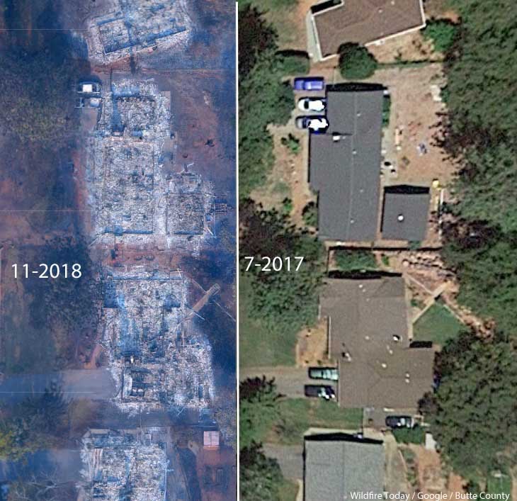
A neighborhood on Debbie Lane in Paradise, California, before and after the Camp Fire that started November 8, 2018. The homes were 14 to 18 feet apart.
Some of the homes in Paradise, California that burned were less than 20 feet apart. According to measurements using Google Earth, we determined that the structures in the photo above were 14 to 18 feet from each other.
The National Institute of Standards and Technology released a report on the 2012 Waldo Canyon Fire that burned 344 homes and killed two people in Colorado Springs, Colorado. They concluded that current concepts of defensible space did not account for hazards of burning primary structures, hazards presented by embers, and the hazards outside of the home ignition zone. In addition, NIST recommended:
High-density structure-to-structure spacing in a community should be identified and considered in [Wildland Urban Interface] fire response plans. In the Waldo Canyon fire, the majority of homes destroyed were ignited by fire and embers coming from other nearby residences already on fire. Based on this observation, the researchers concluded that structure spatial arrangements in a community must be a major consideration when planning for WUI fires.
After studying the Carr Fire that destroyed 1,079 residences at Redding, California earlier this year, retired CAL FIRE Battalion Chief Royal Burnett reached similar conclusions.
It was easy to figure out why the houses on the rim burned — they were looking right down the barrel of a blowtorch. Even though they had fire resistant construction, many had loaded their patios with flammable lawn furniture, tiki bars and flammable ornamental plants. Palm trees became flaming pillars, shredded bark became the fuse, junipers became napalm bombs. Under current standards houses are build 6 to an acre; 10 feet to the property line and only 20 feet between houses. Once one house ignited, radiant heat could easily torch the next one.
2. Envelope of the structure itself
Included in this category are characteristics of the roof, vents, siding, doors, windows, foundation, fences, eaves, and decks. A FEMA publication (13 MB) has excellent detailed recommendations. Headwaters Economics found that the cost of building a fire-resistant home is about the same as a standard home. When implemented, Chapter 7A of the California Building Code, regulates these features.
3. Home Ignition Zone
The NFPA and FireWise programs recommend reducing flammable material within 100 feet of structures and spacing the crowns of trees at least 18 feet apart that are within 30 feet of the home, 12 feet apart at 30 to 60 feet, and 6 feet apart at 60 to 100 feet. Another house that is 15 to 50 feet away is also fuel, and if it ignites will be a serious threat.
Road and driveway width, wide enough for large fire trucks
Turnarounds at the end of roads
Signage, and
Emergency water supply.
Again, the FEMA document has great recommendations.
5. Wildland-Urban Interface
There is of course much that can be done surrounding the places where people live that would reduce the vegetation or fuel and decrease the intensity and ember generation potential of a fire as it approaches an urban area. Large scale fuel management projects including fuel breaks and prescribed fire programs are usually conducted by state and federal agencies.
A fuel break does not have to be devoid of vegetation, but it should have minimal tons per acre that would therefore burn with less intensity and with fewer fire brands being lofted downwind. This could enable firefighters to make a stand and create a place from which to ignite a backfire, perhaps aided by aircraft dropping water or retardant.
6. Fire codes are essential
The only effective way to ensure that residents understand and implement these five tasks is to make them mandatory by establishing Fire Codes at the local and state levels.
Analysts studying the aftermath of the Camp Fire which destroyed much of Paradise, California found that homes built to fire-safe standards had a much higher survival rate than those that were not. Beginning in 2008 new construction in the city was required to follow a standard, Chapter 7A of the California Building Code, designed for the state’s areas at high risk from wildfire. Fifty-one percent of the homes built under the 7A code survived, while only eighteen percent built before 2008 did.
Chapter 7A lays out standards for roofs, exterior walls, vents in exterior walls and attics, windows, exterior doors, decking, and outbuildings. Remember, the cost of building a fire-resistant home is about the same as a standard home.
The warming climate is demonstrating that wildfires are becoming increasingly perilous. It is the responsibility of state and local governments protect their citizens by enacting sensible standards.
The California Department of Forestry and Fire Protection has put together a list of 35 projects around the state where they intend to reduce the wildfire risk for residents. This follows multiple large fire disasters in 2017 and 2018 that killed over 100 people and destroyed tens of thousands of homes. In many areas those not directly affected by the flames were exposed to hazardous levels of smoke for days or weeks at a time.
The State will establish incident bases in proximity to vulnerable communities and coordinate fuels treatment operations from those facilities utilizing the Incident Command System. The Governor will activate the National Guard to help complete the work.
The projects, identified and planned at the local level, are intended to reduce the public safety risk for over 200 communities. Examples of work to be done include removal of hazardous dead trees, vegetation clearing, creation of fuel breaks and community defensible spaces, and establishment of ingress and egress corridors. CAL FIRE believes these projects can be implemented immediately if their recommendations are taken to enable the work.
Recognizing that entry level employees in California are not highly compensated, and often have challenges finding affordable housing in areas where they work, the state will provide additional government housing for seasonal state employees working on forest management and fuels reduction.
In addition to large-scale fuel reduction projects near communities, CAL FIRE understands that residents have to also do their part to reduce the flammable material in their home ignition zone within 100 feet of structures, and especially immediately adjacent — within 5 feet.
Details on the projects can be found online at http://calfire.ca.gov/fire_prevention/downloads/FuelReductionProjectList.pdf. CAL FIRE expects to keep the list updated.
Structures farther apart are less likely to ignite neighboring homes during a wildfire
Deschutes County in Oregon has approved new zoning that will require new construction on the west side of Bend to be low density and fire-resistant.
Oregon Public Broadcasting reports that the new regulation will result in 90 percent fewer homes in the area than the previous code permitted.
One contributing factor that led to more than 15,000 homes being destroyed in two fires in California in 2018, the Camp and Carr Fires, was the close spacing between the structures.
A neighborhood on Debbie Lane in Paradise, California, before and after the Camp Fire that started November 8, 2018. The homes were 14 to 18 feet apart.
Cities, counties, and planning boards (where they exist) are often under pressure to approve new housing developments. They want to expand their tax base. Developers try to fit as many homes into a new subdivision as possible to maximize their investment. This too often results in homes that are 20-feet apart. If one is ignited by a burning ember that may have traveled a quarter of a mile from a fire (or a burning home) the radiant heat alone can ignite the homes on both sides. Then you can have a self-powered conflagration spreading house to house through a city. As long as the structures are that close together, the homeowners have not reduced the fuel in the Home Ignition Zone within 100 feet of the structure, and the home itself is not built to FireWise standards, a massive disaster can be the result.
Reducing the chances that a fire in a populated area will turn into a disaster that burns thousands of homes involves at least three categories of factors, in addition to weather:
Envelope of the structure itself: characteristics of the roof, vents, siding, doors, windows, foundation, fences, eaves, and decks. A FEMA publication (13 MB) has excellent detailed recommendations. Headwaters Economics found that the cost of building a fire-resistant home is about the same as a standard home.
Home Ignition Zone — topography and fuel within 100 feet.
Community infrastructure and planning: distance to nearby structures, evacuation capability, safety zones, road and driveway width, turnarounds at the end of roads, signage, and emergency water supply. Again, the FEMA document has great recommendations.
Jurisdictions need to develop standards for structures, the home ignition zone, and community infrastructure
A neighborhood on Debbie Lane in Paradise, California, before and after the Camp Fire that started November 8, 2018. The homes were 14 to 18 feet apart.
In the weeks after 86 people were killed and over 14,000 homes and businesses were destroyed in the Camp Fire at Paradise, California three influential individuals and organizations urged the consideration of banning or restricting development in areas that are at high risk from wildfires.
First there was the Los Angeles Times Editorial Board on November 24 writing that “To rebuild Paradise as it was, would be land-use malpractice.” The Board continued, “The question facing state and local authorities is whether Paradise — and other towns that have burned — can be rebuilt to withstand the next, inevitable wildfire. If not, how does California relocate communities and restrict new construction while respecting property rights and not worsening the state’s affordable housing crisis? At a minimum, cities should remap fire-prone areas and focus reconstruction in areas with lower risk. “
Then on December 10 the group 1000 Friends of Oregon released “A New Vision for Wildfire Planning” that recommended avoiding development in high risk areas.
Chief Ken Pimlott, March 22, 2016. Photo by Bill Gabbert.
Five days before he retired on December 15 Ken Pimlott, Director of the California Department of Forestry and Fire Protection, was quoted by the Associated Press as saying officials should consider banning home construction in areas vulnerable to wildfires.
Cities, counties, and planning boards (where they exist) are often under pressure to approve new housing developments. They want to expand their tax base. Developers try to fit as many homes into a new subdivision as possible to maximize their investment. This too often results in homes that are 20-feet apart. If one is ignited by a burning ember that may have traveled a quarter of a mile from a fire (or a burning home) the radiant heat alone can ignite the homes on both sides. Then you can have a self-powered conflagration spreading house to house through a city. As long as the structures are that close together, the homeowners have not reduced the fuel in the Home Ignition Zone within 100 feet of the structure, and the home itself is not built to FireWise standards, a massive disaster can be the result.
The NFPA and the FireWise program recommend reducing flammable material within 100 feet of structures, and spacing trees at least 18 feet apart that are within 30 feet of the home. At the 60 to 100-foot distance tree canopies should be at least 6 feet apart. Another house that is 15 to 50 feet away is also fuel and if it ignites will be a serious threat.
If a homeowner wants, or is required, to reduce the flammable material within 100 feet of their residence, what are they expected to do if there is another home 20 feet away that is really a large assembly of flammable material?
Some of the homes in Paradise, California that burned were less than 20 feet apart. According to measurements using Google Earth, the structures in the photo at the top of this article were 14 to 18 feet from each other.
Photo: Anchor Point Group, Boulder, CO
The National Institute of Standards and Technology released a report on the Waldo Canyon Fire that burned 344 homes and killed two people in Colorado Springs, Colorado in June, 2012. They concluded that current concepts of defensible space did not account for hazards of burning primary structures, hazards presented by embers, and the hazards outside of the home ignition zone. In addition, NIST recommended:
High-density structure-to-structure spacing in a community should be identified and considered in [Wildland Urban Interface] fire response plans. In the Waldo Canyon fire, the majority of homes destroyed were ignited by fire and embers coming from other nearby residences already on fire. Based on this observation, the researchers concluded that structure spatial arrangements in a community must be a major consideration when planning for WUI fires.
After studying the Carr Fire that destroyed 1,079 residences at Redding, California earlier this year, retired CAL FIRE Battalion Chief Royal Burnett reached similar conclusions.
It was easy to figure out why the houses on the rim burned — they were looking right down the barrel of a blowtorch. Even though they had fire resistant construction, many had loaded their patios with flammable lawn furniture, tiki bars and flammable ornamental plants. Palm trees became flaming pillars, shredded bark became the fuse, junipers became napalm bombs. Under current standards houses are build 6 to an acre; 10 feet to the property line and only 20 feet between houses. Once one house ignited, radiant heat could easily torch the next one.
We have to learn to live with fire
Reducing the chances that a fire in a populated area will turn into a disaster that burns thousands of homes involves at least three categories of factors, in addition to weather:
Envelope of the structure itself: characteristics of the roof, vents, siding, doors, windows, foundation, fences, eaves, and decks. A FEMA publication (13 MB) has excellent detailed recommendations. Headwaters Economics found that the cost of building a fire-resistant home is about the same as a standard home.
Home Ignition Zone, as described above — topography and fuel within 100 feet.
Community infrastructure and planning: distance to nearby structures, evacuation capability, safety zones, road and driveway width, turnarounds at the end of roads, signage, and emergency water supply. Again, the FEMA document has great recommendations.
Someone asked me recently what needs to be done to keep from repeating disasters like we have seen within the last year at Paradise, Redding, and the Napa Valley. I told him that there is no one thing that needs to be done, such as raking or “forest management”, it requires a comprehensive holistic approach.
The items we have listed here only apply within communities. There is of course much that can be done surrounding the places where people live that would reduce the vegetation or fuel and decrease the intensity and ember generation potential of a fire as it approaches an urban area. Large scale fuel management including fuel breaks and prescribed fire programs are usually conducted by state and federal agencies.
The weakest link in the chain principle applies here. If one of these categories is sub-par, the individual structures and the entire community in a fire-prone environment is at risk. And if a homeowner does not do their part, it can endanger their neighbors.
The warming climate is demonstrating that wildfires are becoming increasingly perilous. It is unlikely that local governments or states are going to ban development in fire-prone environments, but it is their responsibility to protect their citizens by enacting sensible standards.