Tubbs Fire, October, 2017. Photo by Jeff Zimmerman.
Retired Fire Chief John Hawkins has written what he calls a “Major Wildfire Action Plan” for the state of California. The Chief describes the document as “comprehensive and broadly addresses the wildfire problem via the four accepted phases of emergency management: Prevention, Response, Recovery, and Mitigation.”
The catastrophic fires of 2017 and 2018 in California are evidence that something needs to change. Maybe this four-page document will help move the conversation along.
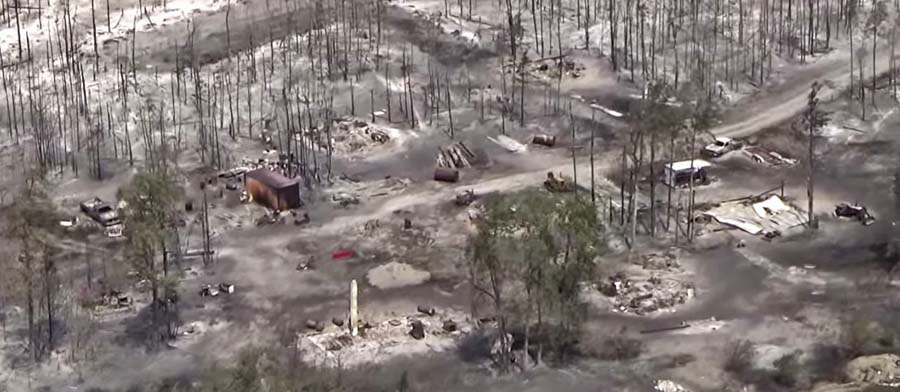
Photo taken on the Camp Fire by a drone in Magalia near Indian Drive.
Pamela Ren Larson and Dennis Wagner of the Arizona Republic studied nearly 5,000 small communities around the West to find out how how many of them are facing large-scale wildfire risk similar to Paradise, California where 19,000 structures burned and 85 people were killed in the Camp Fire. After finding 526 places that have a higher wildfire potential than Paradise, nine reporters set out to report on nine communities in eight states.
Click on the tweet below to reveal the detailed thread which is an introduction to the very detailed reporting that you will see when you click on the links therein. Here is a link to the main story.
About six months ago, I began an enormous project: To find other places like Paradise, California, at risk of wildfire in the West. With wildfire season getting longer, we set out to find these high-hazard communities, ahead of the fire. (THREAD)
BOZEMAN — Ray Rasker, who has researched wildfire for more than a decade as the executive director of Bozeman-based nonprofit Headwaters Economics, makes a bold claim about wildfire and its human impacts.
“We don’t have a forest fire problem, we have a home ignition problem,” he said. “As soon as you come to that realization, it changes your view on wildfire.”
(UPDATE: Ray Rasker contacted us in a comment, below, to say, “The top quote [above] was something I mentioned to the reporter as something that was said by Dr. Jack Cohen, a long-time Fire Science Researcher with the U.S. Forest Service. It’s not my quote and I’m not trying to take credit for Jack’s insightful comment.”)
Often we hear about the costs of suppressing wildfires, but the cost of fire trucks, firefighters, dozers, and aircraft are only part of that cost.
Another excerpt:
Some of a community’s willingness to change growth policies, subdivision regulations, building codes, and the like can be attributed to economics. Although significant, the money spent putting out a wildfire is minor — about 9 percent — relative to fire’s total financial impact, Rasker said. “Fifty percent of the cost is borne by the community. That’s businesses that close, that’s the loss of tax revenue during the fire, that’s the cost of reconstruction — restoring your wetland, for example. Your tax base goes up in flames.”
When economic losses become severe enough, elected officials find the political cover they need to push for additional regulation. Rasker said he’s seen the dynamic at work in several communities CPAW has worked with, including Flagstaff, Arizona; Boulder, Colorado; and San Diego, California. “Now it’s not planning as a liberal agenda; now it suddenly becomes something that’s fiscally responsible.”
Such regulations can include mandating better egress roads to make subdivision evacuations safer, requiring new buildings to be constructed with fire-resistant material, and developing landscaping guidelines for homeowners. There was a time, Rasker said, when municipal fire codes mandating safety measures like sprinkler systems and marked fire exits were all but nonexistent, resulting in casualties. “In an urban environment, we’ve fixed this problem,” he said. “But when the houses are surrounded by trees on the outside of town, suddenly none of those rules apply,” Rasker said, referencing a lack of regulations and enforcement in many rural areas.
Structures that burned in the Puntzi Fire in British Columbia.
A reporter asked me what needs to be done to keep from repeating disasters like we have seen recently in California at Paradise, Redding, and the Napa Valley. I told him that there is no one thing that needs to be done, such as raking or “forest management”, it requires a comprehensive holistic approach.
The principle of the weakest link in the chain applies here. If one of the categories of improvements to protect a development is sub-par, the individual structures and the entire community in a fire-prone environment is at risk. And if a homeowner does not do their part, it can endanger their neighbors.
Reducing the chances that a fire in a populated area will turn into a disaster that burns thousands of homes involves at least six categories of factors: home spacing, envelope of the structure itself, home ignition zone, community infrastructure, wildland urban interface, and fire codes.
Home spacing/lot size
Cities, counties, and planning boards are often under pressure to approve new housing developments. They want to expand their tax base. Developers try to fit as many homes into a new subdivision as possible to maximize their investment. This too often results in homes that are 20-feet apart. If one is ignited by a burning ember that may have traveled a quarter of a mile from a fire (or a burning home) the radiant heat alone can ignite the homes on both sides. Then you can have a self-powered conflagration spreading house to house through a city. When the structures are that close together, the homeowners have not reduced the fuel in the Home Ignition Zone, and the home itself is not built to FireWise standards, a massive disaster can be the result.
If a homeowner wants, or is required, to reduce the flammable material within 100 feet of their residence, what are they expected to do if there is another home 20 feet away that is really a large assembly of flammable material?
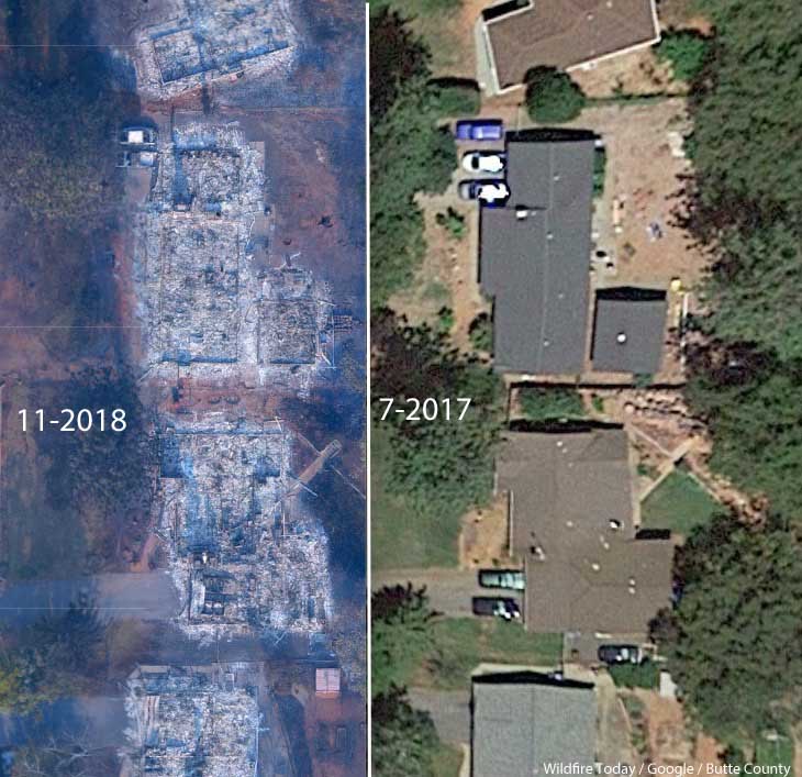
A neighborhood on Debbie Lane in Paradise, California, before and after the Camp Fire that started November 8, 2018. The homes were 14 to 18 feet apart.
Some of the homes in Paradise, California that burned were less than 20 feet apart. According to measurements using Google Earth, we determined that the structures in the photo above were 14 to 18 feet from each other.
The National Institute of Standards and Technology released a report on the 2012 Waldo Canyon Fire that burned 344 homes and killed two people in Colorado Springs, Colorado. They concluded that current concepts of defensible space did not account for hazards of burning primary structures, hazards presented by embers, and the hazards outside of the home ignition zone. In addition, NIST recommended:
High-density structure-to-structure spacing in a community should be identified and considered in [Wildland Urban Interface] fire response plans. In the Waldo Canyon fire, the majority of homes destroyed were ignited by fire and embers coming from other nearby residences already on fire. Based on this observation, the researchers concluded that structure spatial arrangements in a community must be a major consideration when planning for WUI fires.
After studying the Carr Fire that destroyed 1,079 residences at Redding, California earlier this year, retired CAL FIRE Battalion Chief Royal Burnett reached similar conclusions.
It was easy to figure out why the houses on the rim burned — they were looking right down the barrel of a blowtorch. Even though they had fire resistant construction, many had loaded their patios with flammable lawn furniture, tiki bars and flammable ornamental plants. Palm trees became flaming pillars, shredded bark became the fuse, junipers became napalm bombs. Under current standards houses are build 6 to an acre; 10 feet to the property line and only 20 feet between houses. Once one house ignited, radiant heat could easily torch the next one.
2. Envelope of the structure itself
Included in this category are characteristics of the roof, vents, siding, doors, windows, foundation, fences, eaves, and decks. A FEMA publication (13 MB) has excellent detailed recommendations. Headwaters Economics found that the cost of building a fire-resistant home is about the same as a standard home. When implemented, Chapter 7A of the California Building Code, regulates these features.
3. Home Ignition Zone
The NFPA and FireWise programs recommend reducing flammable material within 100 feet of structures and spacing the crowns of trees at least 18 feet apart that are within 30 feet of the home, 12 feet apart at 30 to 60 feet, and 6 feet apart at 60 to 100 feet. Another house that is 15 to 50 feet away is also fuel, and if it ignites will be a serious threat.
Road and driveway width, wide enough for large fire trucks
Turnarounds at the end of roads
Signage, and
Emergency water supply.
Again, the FEMA document has great recommendations.
5. Wildland-Urban Interface
There is of course much that can be done surrounding the places where people live that would reduce the vegetation or fuel and decrease the intensity and ember generation potential of a fire as it approaches an urban area. Large scale fuel management projects including fuel breaks and prescribed fire programs are usually conducted by state and federal agencies.
A fuel break does not have to be devoid of vegetation, but it should have minimal tons per acre that would therefore burn with less intensity and with fewer fire brands being lofted downwind. This could enable firefighters to make a stand and create a place from which to ignite a backfire, perhaps aided by aircraft dropping water or retardant.
6. Fire codes are essential
The only effective way to ensure that residents understand and implement these five tasks is to make them mandatory by establishing Fire Codes at the local and state levels.
Analysts studying the aftermath of the Camp Fire which destroyed much of Paradise, California found that homes built to fire-safe standards had a much higher survival rate than those that were not. Beginning in 2008 new construction in the city was required to follow a standard, Chapter 7A of the California Building Code, designed for the state’s areas at high risk from wildfire. Fifty-one percent of the homes built under the 7A code survived, while only eighteen percent built before 2008 did.
Chapter 7A lays out standards for roofs, exterior walls, vents in exterior walls and attics, windows, exterior doors, decking, and outbuildings. Remember, the cost of building a fire-resistant home is about the same as a standard home.
The warming climate is demonstrating that wildfires are becoming increasingly perilous. It is the responsibility of state and local governments protect their citizens by enacting sensible standards.
Homes in Paradise, California built to fire-safe codes had a much higher survival rate in the Camp Fire
Camp Fire, as it began to burn into Paradise, Calif. LANDSAT 8 image at 10:45 a.m. PT, Nov. 8, 2018. Processed by Zeke Lunder, Deer Creek Resources, Chico, Calif.
Analysts studying the aftermath of the Camp Fire which destroyed much of Paradise, California found that homes built to fire-safe standards had a much higher survival rate than those that were not.
Beginning in 2008 new construction in the city was required to follow a standard, known as the 7A Code, designed for the state’s areas at high risk from wildfire, requiring fire-resistant roofs, siding and other safeguards. Fifty-one percent of the homes built under the 7A code survived, while only eighteen percent of those built before 2008 did.
While this would seem like an easy lesson to learn, some areas in the state are reluctant to apply the fire-safe standard.
Below is an excerpt from an editorial at the Sacramento Bee:
“…As many as 3 million homes stand in what the state calls “very high fire hazard severity zones,” according to Cal Fire. These areas, where the climate and the presence of combustible foliage can lead to tinderbox conditions, are destined to burn. The data on which homes survived the Camp Fire should be a call to action for every city in the danger zones.
“Unfortunately, short-term thinking can triumph over common sense. Cities facing severe fire risks can avoid compliance with the fire-resistant building codes, or choose to avoid their obvious advantages, despite the fact that “a new home built to wildfire-resistant codes can be constructed for roughly the same cost as a typical home,” according to a report by Headwaters Economics.
“Take Santa Rosa’s Coffey Park neighborhood, where the Tubbs Fire killed five people and destroyed 1,321 homes in 2017. The neighborhood wasn’t considered a fire hazard zone, unlike some other areas of Santa Rosa. The Tubbs Fire proved otherwise, but Coffey Park still isn’t designated as a “very high fire hazard zone” by Cal Fire.
“ ‘City officials are OK with that,” according to The Bee. “Although developers rebuilding Coffey Park are being urged to consider fire-resistant materials, city spokeswoman Adriane Mertens said the city doesn’t see any reason to impose the 7A code in the neighborhood.’ “
Jurisdictions need to develop standards for structures, the home ignition zone, and community infrastructure
A neighborhood on Debbie Lane in Paradise, California, before and after the Camp Fire that started November 8, 2018. The homes were 14 to 18 feet apart.
In the weeks after 86 people were killed and over 14,000 homes and businesses were destroyed in the Camp Fire at Paradise, California three influential individuals and organizations urged the consideration of banning or restricting development in areas that are at high risk from wildfires.
First there was the Los Angeles Times Editorial Board on November 24 writing that “To rebuild Paradise as it was, would be land-use malpractice.” The Board continued, “The question facing state and local authorities is whether Paradise — and other towns that have burned — can be rebuilt to withstand the next, inevitable wildfire. If not, how does California relocate communities and restrict new construction while respecting property rights and not worsening the state’s affordable housing crisis? At a minimum, cities should remap fire-prone areas and focus reconstruction in areas with lower risk. “
Then on December 10 the group 1000 Friends of Oregon released “A New Vision for Wildfire Planning” that recommended avoiding development in high risk areas.
Chief Ken Pimlott, March 22, 2016. Photo by Bill Gabbert.
Five days before he retired on December 15 Ken Pimlott, Director of the California Department of Forestry and Fire Protection, was quoted by the Associated Press as saying officials should consider banning home construction in areas vulnerable to wildfires.
Cities, counties, and planning boards (where they exist) are often under pressure to approve new housing developments. They want to expand their tax base. Developers try to fit as many homes into a new subdivision as possible to maximize their investment. This too often results in homes that are 20-feet apart. If one is ignited by a burning ember that may have traveled a quarter of a mile from a fire (or a burning home) the radiant heat alone can ignite the homes on both sides. Then you can have a self-powered conflagration spreading house to house through a city. As long as the structures are that close together, the homeowners have not reduced the fuel in the Home Ignition Zone within 100 feet of the structure, and the home itself is not built to FireWise standards, a massive disaster can be the result.
The NFPA and the FireWise program recommend reducing flammable material within 100 feet of structures, and spacing trees at least 18 feet apart that are within 30 feet of the home. At the 60 to 100-foot distance tree canopies should be at least 6 feet apart. Another house that is 15 to 50 feet away is also fuel and if it ignites will be a serious threat.
If a homeowner wants, or is required, to reduce the flammable material within 100 feet of their residence, what are they expected to do if there is another home 20 feet away that is really a large assembly of flammable material?
Some of the homes in Paradise, California that burned were less than 20 feet apart. According to measurements using Google Earth, the structures in the photo at the top of this article were 14 to 18 feet from each other.
Photo: Anchor Point Group, Boulder, CO
The National Institute of Standards and Technology released a report on the Waldo Canyon Fire that burned 344 homes and killed two people in Colorado Springs, Colorado in June, 2012. They concluded that current concepts of defensible space did not account for hazards of burning primary structures, hazards presented by embers, and the hazards outside of the home ignition zone. In addition, NIST recommended:
High-density structure-to-structure spacing in a community should be identified and considered in [Wildland Urban Interface] fire response plans. In the Waldo Canyon fire, the majority of homes destroyed were ignited by fire and embers coming from other nearby residences already on fire. Based on this observation, the researchers concluded that structure spatial arrangements in a community must be a major consideration when planning for WUI fires.
After studying the Carr Fire that destroyed 1,079 residences at Redding, California earlier this year, retired CAL FIRE Battalion Chief Royal Burnett reached similar conclusions.
It was easy to figure out why the houses on the rim burned — they were looking right down the barrel of a blowtorch. Even though they had fire resistant construction, many had loaded their patios with flammable lawn furniture, tiki bars and flammable ornamental plants. Palm trees became flaming pillars, shredded bark became the fuse, junipers became napalm bombs. Under current standards houses are build 6 to an acre; 10 feet to the property line and only 20 feet between houses. Once one house ignited, radiant heat could easily torch the next one.
We have to learn to live with fire
Reducing the chances that a fire in a populated area will turn into a disaster that burns thousands of homes involves at least three categories of factors, in addition to weather:
Envelope of the structure itself: characteristics of the roof, vents, siding, doors, windows, foundation, fences, eaves, and decks. A FEMA publication (13 MB) has excellent detailed recommendations. Headwaters Economics found that the cost of building a fire-resistant home is about the same as a standard home.
Home Ignition Zone, as described above — topography and fuel within 100 feet.
Community infrastructure and planning: distance to nearby structures, evacuation capability, safety zones, road and driveway width, turnarounds at the end of roads, signage, and emergency water supply. Again, the FEMA document has great recommendations.
Someone asked me recently what needs to be done to keep from repeating disasters like we have seen within the last year at Paradise, Redding, and the Napa Valley. I told him that there is no one thing that needs to be done, such as raking or “forest management”, it requires a comprehensive holistic approach.
The items we have listed here only apply within communities. There is of course much that can be done surrounding the places where people live that would reduce the vegetation or fuel and decrease the intensity and ember generation potential of a fire as it approaches an urban area. Large scale fuel management including fuel breaks and prescribed fire programs are usually conducted by state and federal agencies.
The weakest link in the chain principle applies here. If one of these categories is sub-par, the individual structures and the entire community in a fire-prone environment is at risk. And if a homeowner does not do their part, it can endanger their neighbors.
The warming climate is demonstrating that wildfires are becoming increasingly perilous. It is unlikely that local governments or states are going to ban development in fire-prone environments, but it is their responsibility to protect their citizens by enacting sensible standards.