Canadians Aid U.S. Firefighting Effort 

canadian firefighters Missoula airport
The Canadian firefighters gather around a firefighter memorial at the USFS Aerial Fire Depot and Smokejumper Center at Missoula International Airport. In the background is the smokejumper’s DC-3. Photo courtesy Alberta Ministry of Agriculture and Forestry.

This article was written by Rae Brooks while she was working as a Public Information Officer on the Motorway Complex of fires in north-central Idaho.

KOOSKIA, Idaho — We call it extended attack. They call it “sustained action.”  We build fire line. They build “fire guard.”  Our fires are finished when they’re controlled.  They don’t stop until they’re at “extinguishment.”

The Canadian firefighters who spent two weeks filling leadership positions on the Motorway Complex of fires in north-central Idaho might talk about fire a little differently — and even fight it differently — but they found they share the same goals as American firefighters.

“Swinging a Pulaski is the same from High Level to Florida,” said Canadian firefighter Wade Klein, who served as a task force leader on the Slide Fire.  “When it comes down to it,” added colleague Gregory Williams-Freeman, a task-force leader on the Woodrat Fire, “fire is fire, and we all know that business.”

High Level, by the way, is a town in northern Alberta.  Although the common incident command system used by both countries minimized differences, a few other translations were needed to integrate the Canadians into the U.S. firefighting operation.

The fire behavior analyst, for example, started adding metric conversions for chains and rates of spread at the morning briefing.  The word hectares came up occasionally in lieu of acres.  And the Canadians, all from the western province of Alberta, had to get used to talking about percentage of containment, instead of their usual categories for fires: Out of Control, Being Held, Under Control and Extinguishment.

The Albertans came to Idaho through a joint agreement between the United States and Canada that allows each country to call in firefighting resources from the other in times of need. Under the same agreement, American firefighters flew to Canada to help out in July at the height of an intense fire season in western Canada.

Last month, after a lightning burst sparked dozens of fires across Idaho and the Pacific Northwest, it was the Americans’ turn to call for international assistance.  Besides Alberta, Canada also sent firefighters from Ontario and the Yukon.  Australia and New Zealand also aided the effort.

canadian firefighters at Woodrat fire
Three Canadians confer during division breakout on the Woodrat Fire after morning briefing at the Motorway Complex. Left to right: Division supervisor Mark Handel, task-force leaders Jason, Cottingham, and Alan Gammon.​ Photo by Rae Brooks.

The 23 Alberta firefighters working under Mark Ruggiero’s Southwest Area Type 1 Incident Management Team at the Motorway Complex included six division supervisors, 10 task force leaders, four heavy equipment bosses, a helibase manager and two helicopter crew members. Kris Heemeryck accompanied the group as a representative of the Alberta Ministry of Agriculture and Forestry.

It was the Albertans’ first exposure to a U.S. Type 1 team in action.  They praised the chow-line food, the clean showers and the well-stocked medics.  They also appreciated being able to eat outside under open-sided tents.  At Alberta fire camps, mosquitoes and black flies force firefighters to dine inside in oil-field trailers.

Phil Bruner was serving as groomsman at a crew member’s wedding in Edmonton when he got the word about the Idaho assignment.  He stepped out of the church after the ceremony and turned his cell phone on to find his supervisor had called to see if he wanted to go fight fire in the United States.

Bruner deliberated for half an hour.  He had tickets to a music festival he had looked forward to attending for months, which he would miss if he took the assignment.  But Canadian firefighters almost always fight fires only in their own provinces.  Interprovincial requests come infrequently.  International requests are even rarer.

Finally he phoned a friend for advice.  “He didn’t even ask why I didn’t want to go,” said Bruner.  “He just said, “Don’t be dumb. Go.”

canada Fire shelter training.
Fire shelter training. Photo by Kris Hemmeryck.

A total of 42 Alberta firefighters flew to Missoula, Montana, on Aug. 24 on a jet contracted by the National Interagency Fire Center for two days of briefings, including an introduction to fire shelters.  Canadian firefighters don’t normally carry them.

About half the group was assigned to other fires in Idaho and Montana.  Some of the group of 24 that ended up at the Motorway Complex started out at another complex to the north.  The differences between Canadian and U.S. firefighting techniques quickly became apparent.

Because of the vast distances involved, the lack of roads and the need for a speedy response, almost all initial attack in Alberta is done by helicopter.  The Albertans generally fight fire with water, because they have it, rarely building hand line, especially in the flat, swampy northern part of the province where the duff may be six-feet deep.

Instead of building line, they rely on hose lays or dozers to encircle fires.  When an area is dry enough, dozers work in groups of three, with the lead dozer knocking timber down, the second pushing it away from the fire, and the third clearing a line down to mineral soil.

In Idaho, the Canadians found U.S. hot shot crews performing the same task, but in a manner more suited to the terrain and vegetation: constructing hand line, then burning off those lines.  The Albertans do very little hand ignition, relying more on helitorching.

Alberta firefighters generally are transported to and from the fire line by helicopter.  They immediately start laying hose, while helicopters do bucket drops, with added support from air tankers.  With a raging crown fire, they don’t stop to deploy hose, instead relying on an aggressive air attack.  When extinguishing hotspots, Alberta firefighters sometimes have to use chain saws to cut several layers of duff blocks to ensure the spot is properly cooled.

In Idaho, the Albertans also ran into wildland-urban interface issues they don’t normally face, working close to — and even in — the communities of Syringa and Lowell.  In contrast, Alberta’s forests, especially in the north, are largely empty.  Alberta is about the same size as California and Nevada combined, but has just a tenth of the population.

“Where we work is so remote, there’s only a cabin or two,” said Dave Leegstra, task-force leader on the Woodrat Fire.  “Here it was houses, and lots of them.”  Added Bruner, a task-force leader on Slide: “Our wildland-urban interface is flying into lookouts and trappers’ cabins and putting up sprinkler systems.”

Williams-Freeman, another task-force leader, worked closely with the Lolo Hotshots and was so impressed by them that he hopes to join them for a season.  As a member of the Blackfeet Nation, Williams-Freeman is entitled to dual Canadian-U.S. citizenship, so is able to work in the United States.  He picked the Hotshots’ brains and carefully studied their set-up to get ideas for his own unit crew, the more plainly titled Alberta hotshot equivalent.

Unit crews were created in Alberta just four years ago.  Unlike U.S. hotshot crews, nothing separates them visually from other crews.  They wear the same garb as other Alberta firefighters and their 20-person crews drive around in five pickup trucks, not the distinctive buggies of U.S. hotshots.

Last week, on the last day of their assignment, the dawn morning briefing at the incident command post where most of the Albertans were billeted included a presentation of a personalized thank-you certificate and a Southwest Area challenge coin to each Canadian firefighter. Inscribed at the certificate’s bottom: “Geography made us neighbors; working together made us friends.”

The tough crowd of division supervisors, task-force leaders, crew bosses, engine bosses and other fire leaders saluted the Albertans by singing the first few bars of Canada’s national anthem to their new fire friends.

Bear bites sleeping firefighter

grizzly bear
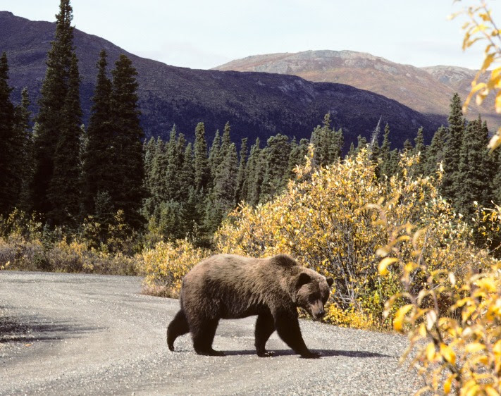
File image of a grizzly bear in Denali National Park. Photo by Bill Gabbert.

Tuesday night a bear bit a sleeping firefighter who was trying to get some rest between shifts while assigned to a wildfire near McCall, Idaho. The firefighter was taken to the hospital, treated for minor wounds and released, then he returned to work, according to Forest Service officials.

A bear believed to be the perp was later trapped and euthanized. Idaho Fish and Game will check to see if DNA from the bear matches saliva the animal left on the firefighter’s small tent, known as a bivvy sack that he was sleeping in when the bite occurred. However, it’s uncertain whether there will be enough DNA on the bivvy sack to get a match.

Fish and Game had reports of a bear in the area raiding garages and causing property damage. Agency personnel had set a trap prior to the bear biting the firefighter, but hadn’t been able to catch it.

In June, 2015 a firefighter working on the Juneau Lake Fire in the Chugach National Forest in Alaska sustained minor injuries in a bear encounter. The firefighter was transported by a life med helicopter from the remote Juneau Lake site (map) to a hospital in Anchorage. The firefighter walked from the encounter site to the helicopter and was treated at the hospital for animal bites.

In 2008 a firefighter working on the LeHardy fire in Yellowstone National Park received some minor injuries from an encounter with a grizzly bear which may have been trying to leave the fire area but the firefighter was unknowingly in its path. The firefighter was treated and released at the Yellowstone Clinic.

Precipitation last 7 days

Precipitation last 7 days. September 5, 2015.
Observed precipitation last 7 days. September 5, 2015. NOAA.

The above map shows precipitation during the seven days preceding September 5, 2015. Some areas in Montana, Idaho, Washington, and Oregon received over an inch.

The map below is the observed precipitation today, September 5, 2015. This rainfall over the last week, and in some cases snow, probably will not put out the large fires, but will certainly slow them down.

Observed precipitation on September 5, 2015
Observed precipitation on September 5, 2015. NOAA.

Soda Fire in Idaho nears containment

(UPDATED at 4:25 p.m. MT, August 18, 2015)

Fire managers are calling the Soda fire southwest of Boise, Idaho, 90 percent contained.

The demobilization process will begin today, August 18, and most firefighting resources will be reassigned to other fires in the west. The remaining crews and engines will continue to patrol, look for any smokes, and assist in the rehabilitation of containment lines.

As the Soda Fire nears 100% containment, a federal Burned Area Emergency Response (BAER) Team is being convened to begin field work as early as Wednesday. The BAER Team of natural resource specialists will assess damage and design emergency stabilization and rehabilitation treatments for BLM lands. This assessment focuses on mitigating threats to life, property, and resources within the burned area over the next 3 years.

The Rocky Mountain Incident Management Team will be transitioning the Soda Fire to a local BLM Type 3 Team at 6am Wednesday, August 19, 2015.

This will be our last update on the Soda Fire unless there is a significant upward change in fire activity.

(Update June 3, 2016: the final size was 279,144 acres.)

****

(UPDATED at 9:18 a.m. MT, August 15, 2015)

Map Soda Fire
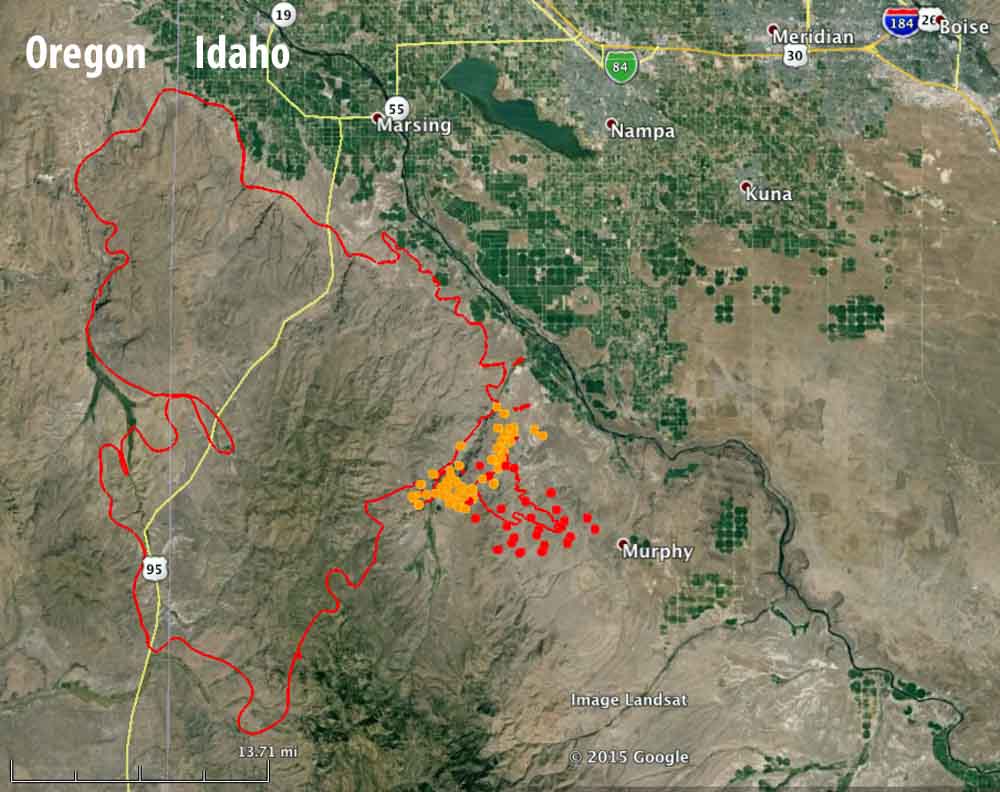
Map of the Soda Fire (red line) at 9 p.m. MT, August 14, 2015. The brown and red dots represent heat detected by a satellite as late as 10:05 p.m. MT, August 14, 2015. The fire was actively spreading near the location of the red dots at that time — the red dots were the most current. (click to enlarge)

Friday evening the Soda Fire only had one area that with a large amount of fire activity, and that was on the southeast side where the fire was spreading to the southeast in the direction of Murphy, Idaho. This fire is very hard for heat-sensing mapping systems to track because in many areas the vegetation is grass or light brush that ignites, burns up quickly, and may cool off before an infrared aircraft or heat-sensing satellite passes over.

The fire has burned about 265,000 acres.

From InciWeb, August 14, 2015:

The Owyhee County Dispatch issued notification for residents to prepare for evacuations in the Bailey Road, Reynolds Road near feedlot, China Ditch, and Wilson Creek due to extreme fire behavior caused by high winds and terrain that is aligned with the wind. Highway 78 open at this time.

There is limited air support at this time due to the very high winds (30-40 mph). A very large air tanker was used throughout the day in conjunction with crews and dozers to construct containment lines along the Willow and Reynolds Creek areas.

Friday afternoon the wind was gusting at 30 to 43 mph out of the southwest and later the northwest, while the relative humidity got as low as 8 percent at 7 p.m. The forecast on Saturday for the southeast portion of the fire is for 81 degrees, 18 percent RH, mostly sunny skies, and 10 mph winds from the northwest shifting to the north in the afternoon. With the lower wind speeds on Saturday the fire should not spread as quickly as it did Friday afternoon.

****

(UPDATED at 12:36 p.m. MT, August 14, 2015)

soda fire
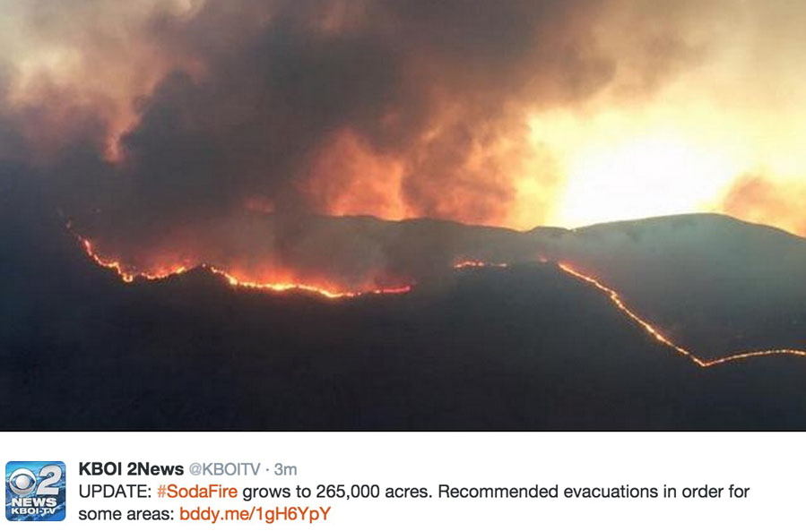
A tweet by KBOI at about 10:30 a.m. MT, August 14, 2015.

At 2 a.m. on August 14, the Owyhee County Sheriffs office recommended (but did not require) an evacuation near the Soda Fire for the Wilson Creek area south of Hwy 78 at milepost 16 through 18 due to increased fire activity. This area includes the Gibbons Hot Springs and the Hard Trigger Road. The Sheriff is asking people to please be prepared to evacuate. There are no mandatory evacuation orders in place on the Soda Fire.

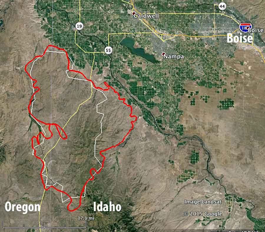
The blaze is burning grass and sagebrush in Oregon and Idaho 14 miles southwest of Caldwell and 11 miles southwest of Nampa, Idaho (see the map below). The incident management team reports it has now blackened 265,000 acres.

Friday could be a big day on the fire, and dangerous for firefighters.  The area is under a Red Flag Warning from noon on Friday until midnight for southwesterly winds reaching 18 to 25 mph with gusts to 35 mph in the afternoon. Friday night the wind will shift to come out of the west and then the northwest. The relative humidity will dip to 10 to 15 percent Friday afternoon.

You can monitor the weather conditions updated once an hour at the Owyhee weather station, 5 miles west of the northern end of the fire. At 11:52 a.m. on Friday it recorded 85 degrees, 14 percent humidity, and southwest winds of 8 mph gusting to 17 mph.

soda fire
The red line represents the perimeter of the Soda Fire as mapped by an aircraft at 2 a.m. MT Aug 14, 2015. The white line was the perimeter the day before, and was an estimate Wildfire Today developed based on heat detected by a satellite.

Strong winds Thursday night caused increased fire activity in the Reynolds Creek and Wilson Creek drainages on the southeast flank of the fire. Over 300 additional firefighting resources were put in place to reinforce the line through the night.

The Rocky Mountain Type 1 Incident Management Team led by Incident Commander Todd Pechota will shadow Great Basin Incident Management Team 5 Friday in preparation for assuming command of the southern section of the fire Saturday morning.

****

(UPDATED at 5:50 p.m. MT, August 13, 2015)

Soda Fire Aug 13, 2015
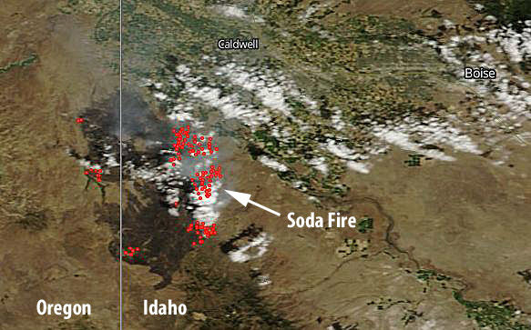
Satellite image of the Map showing the Soda Fire, August 13, 2015, showing smoke drifting toward the northwest. The red dots represent heat. NASA.

Continue reading “Soda Fire in Idaho nears containment”

Fire near Boise Wednesday afternoon

Fire near Boise 7-22-2015

Richard McCrea sent us this photo he took of a fire near Boise Wednesday afternoon. It looks like three engines are taking care of the left side while a single engine air tanker completes a drop on the bottom end.

Mr. McCrea said the firefighter’s successful efforts were aided by rain as they stopped the spread.

Campers rescued by boat on the Cape Horn Fire

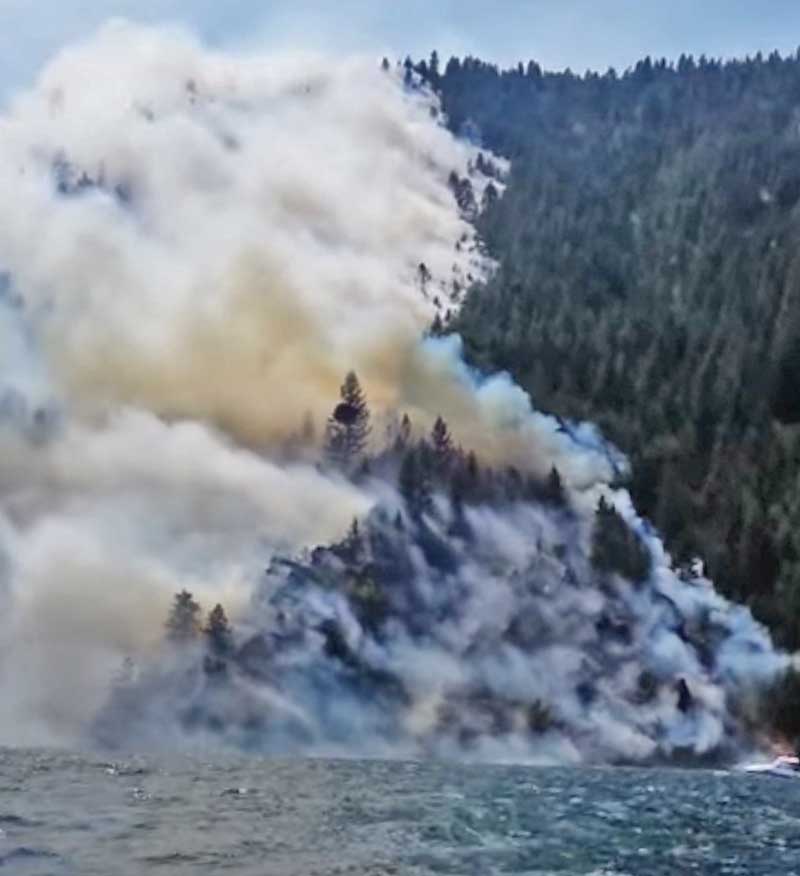
A boater rescued campers who were stranded on the shore of a lake while the Cape Horn Fire was burning close to their camp site. The campers appeared to have a boat in their small cove that was partially submerged in Lake Pend Oreille. Near the beginning of the video you can hear a voice saying, “hey those people are waving to us.”

The people in the boat from which the video was shot were considering going in to rescue the individuals, and shouted “You’ll have to leave your stuff!”, but later another boat arrived that picked up the campers.

These photos are screen grabs from the video that was uploaded to YouTube by John Stenberg on June 6.

The 1,380-acre Cape Horn Fire in northern Idaho has destroyed six homes and two outbuildings. The incident management team reports that a fireline has been established around “much of the fire”, however some evacuations are still in effect.

Cape Horn Fire
Cape Horn Fire

Cape Horn Fire

The Tweet below is from a reporter, and includes some good photos of the fire. Click on them to see larger versions.