Rollover of a trailer loaded with a dozer on Cougar Creek Fire

Above: A trailer loaded with a D-5 dozer rolled over on the Cougar Creek Fire in Idaho August 10, 2018. Incident Management Team photo.

(Updated at 8:55 a.m. PDT September 6, 2018)

A trailer loaded with a Caterpillar D-5H dozer rolled over while it was being relocated on the Cougar Creek Fire about 26 miles west of Chelan, Washington. A Peterbilt dump truck was pulling the triple-axle transport trailer as it travelled downhill on USFS Road 5700 near Pine Flats Campground.

About halfway down the grade the driver said the brakes failed on both the truck and the trailer. As the speed increased on the curvy one-lane road the driver attempted to slow down by driving off the edge of the road in soft dirt. After negotiating several curves the trailer climbed up a bank causing it to tip over onto its side. The truck and the trailer came to a stop on the road.

The report we saw did not indicate that the truck rolled over, but it had damage to the front end, bumper, headlights, and the rear trailer hitch. On the trailer the hitch was damaged and three tires were punctured. There was some damage to the dozer but the driver was not injured.

The preliminary report suggested to prevent similar accidents drivers should use lower gears and slower speeds when driving downhill to reduce overheating the brakes.

The accident occurred at 4:10 p.m. on August 10. We have an unconfirmed report that approximately 200 contractors and agency personnel were trapped due to the blocked road and had to remain without logistical support overnight at a drop point which did not qualify as a safety zone.  When the Rapid Lesson Sharing team arrived the next day at least some of the personnel refused to speak to them about the incident.

(This article was revised to clarify that the incident occurred on the Cougar Creek Fire, rather than the Cougar Fire.)

Two fire engines burned on the North Eden Fire in Utah

Two fire vehicles fighting the North Eden Wildfire were destroyed August 17 by wind-driven flames. A heavy engine from Woodruff Fire Department and a light engine from the State Division of Forestry Fire & State Lands responded to the fire’s west flank.

One engine experienced a mechanical problem and as both crews tried to make the vehicle mobile again flames quickly moved toward the scene cutting off their escape route. The group of three firefighters was forced to leave the vehicles and escape into the black. No injuries were reported.

The 13,753-acre fire is burning in Utah, Idaho, and Wyoming.– a rare three-state fire.

Thanks and a tip of the hat go out to Tom.
Typos or errors, report them HERE.

Interview with Kari Greer about her photography exhibit in Missoula

Above: Kari Greer, wildfire photographer, at a reception for the opening of her exhibit at the University of Montana May 21, 2018.

Tuesday we had an opportunity to interview Kari Greer about her “Facing the Inferno” exhibit of wildfire photography. It is on display for three days, May 21-23, during the Fire Continuum Conference at the University of Montana in Missoula in the University Center, room 227.

The photos in the exhibit are borrowed from the main venue showing her photography which was at the Prichard Art Gallery on the campus of the University of Idaho until April 14, 2018.

Kari is a very well respected and skilled wildland fire photographer who has specialized in the field for years.

BLM: fuel breaks stopped spread of Centennial Fire

The BLM fuel breaks are initially created by using herbicides

Above: screenshot from the BLM video showing a fuel break.

(Originally published at 10 a.m. MST December 2, 2017)

The Bureau of Land Management produced this video that explains their philosophy of creating fuel breaks in Idaho by using herbicides followed by planting fire resistant vegetation such as “Stabilizer” Siberian wheatgrass. The 2017 Centennial Fire west of Twin Falls would have grown much larger, they claim, had it not stopped at a fuel break 275 feet wide.

fuel break herbicide aerial application
An aircraft sprays herbicide on a BLM fuelbreak. Screenshot from the BLM video.

Wildfires persist in the Cascades and Northern Rockies

Today there are 71 large uncontained wildfires in the United States.

Above: the red and orange dots on the map represent heat on wildfires detected by a satellite in the 24 hours before 7:30 a.m. MDT September 11, 2017. Heat found before that is not shown.

(Originally published at 7:45 a.m. MDT September 11, 2017)

In spite of the hurricanes impacting the southeast United States, the wildfires in the Cascade Range and the Northern Rockies persevere in Montana, Idaho, Oregon, Washington, and Northern California.

Off and on over the last week they have slowed as clouds and even some scattered very light showers passed over the areas, but the National Interagency Fire Center reported today there are 71 active large fires, 32 that are being suppressed and 39 that are being suppressed only where needed to protect property.

So far this year 8.2 million acres have burned in the United States, which is 46 percent higher than the 5.6 million average to this date.

Red Flag Warning Northwest Montana
Red Flag Warning for Northwest Montana, September 11, 2017. There is a Fire Weather Watch due to “abundant lightning on dry fuels” predicted Tuesday afternoon for areas in northern California and south-central Oregon.

The weather for Monday and Tuesday could be conducive to fire growth, especially in Northwest Montana where a Red Flag Warning is in effect Monday. But Wednesday through Saturday will bring a chance of rain to Idaho and Western Montana, while the forecast for Northern California, Oregon, and Washington looks dry this week.

Weather forecast Wednesday September 13
Weather forecast for Wednesday September 13, 2017. Weather.com

Satellite detects heat from wildfires, September 7

(Originally published at 6:36 p.m. MDT September 7, 2017.)

Large wildfires Washington Oregon northern California
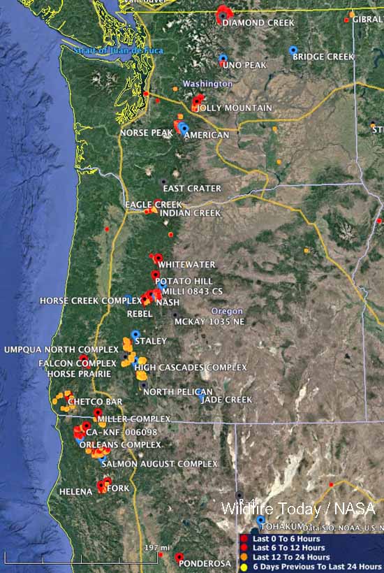
Large wildfires currently active in Washington, Oregon, and northern California. The red, yellow, and orange dots represent heat detected by a satellite in the 24 hour period ending at 10 a.m. MDT September 6.

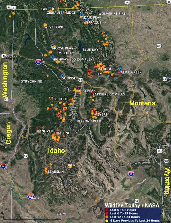
These maps show heat that was detected by a satellite on wildfires in the northwestern United States during the 24-hour period ending at 6 p.m. Thursday September 7, 2017. We did not include heat from the 6 days previous to the last 24 hours.

If there was heat found, it means the fires are still active, however some of it could be from proactive burning by firefighters to secure the area between firelines and the edge of the fires.

map wildfires idaho montana
Large wildfires currently active in Montana and Idaho. The red, yellow, and orange dots represent heat detected by a satellite in the 24 hour period ending at 6 p.m. MDT September 7.