Wildfire briefing, June 28, 2013

Former volunteer firefighter sentenced for arson

The San Francisco Chronicle reports that a former volunteer firefighter was sentenced to a total of two years in jail for setting fires in the northern California counties of Sonoma and San Mateo. Our original story on the charges is here, and the Chronicle has the details about Friday’s sentencing of Nathaniel Ridgway Schmidt, 20, of Cazadero, California.

Extreme heat forecast for some areas in the West

This weekend and the first part of next week some areas in the west will experience extremely hot weather. The temperature for Death Valley was expected to reach nearly 130 on Friday — just short of the 134-degree reading from a century ago that stands as the highest temperature ever recorded on Earth. More details.

This is a good time for firefighters to review the video on Heat Related Illness.
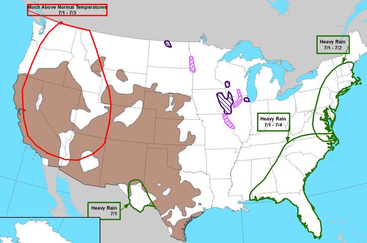
Heat wave map NWS 3-7 day outlook
Much above normal temperatures are forecast for parts of the West on July 1-3, 2013. Map: NOAA and FEMA.

Helicopter crashes into river near Missoula

A helicopter made a crash landing into a river Friday while recertifying for water bucket operations near Missoula, Montana. Both the pilot and a passenger survived, according to an article in the Missoulian. More details are at Fire Aviation.

Colorado: West Fork Complex Fire
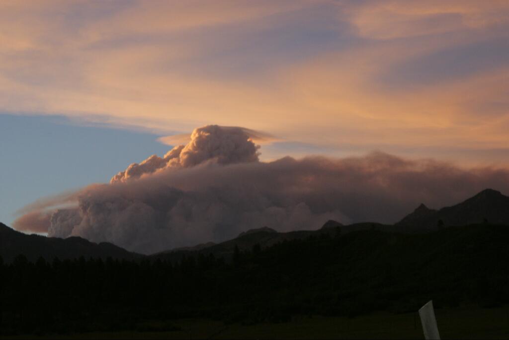
West Fork Complex, June 25, 2013
Smoke from the West Fork Complex at sunset, June 25, 2013 by @PagosaCabin

The Papoose Fire, part of the West Fork Complex of fires in southern Colorado, was extremely active Thursday night and early Friday morning, running for four miles and creating new spot fires 1 to 1.5 miles ahead. More details are in our main article about the fire.

New York Times on smaller budgets for fuel management

The New York Times is the latest news organization to run a major story on how the federal government is reducing the budgets for prescribed fire and other types of fuel mitigation which lower the fire risk by removing accumulations of thick vegetation in forests and in wildland-urban interfaces near populated areas. Here is an excerpt from their article:

The government has cut back on programs to reduce fire risks in areas where homes and the wilderness collide. The United States Forest Service treated 1.87 million acres of those lands in 2012, but expects to treat only 685,000 acres next year. Conservation advocates say that is likely to mean fewer people working to prevent runaway fires, fewer controlled burns and fewer trucks hauling away dry brush and tinder.

Trimming trees and clearing brush can make blazes less destructive, and the Forest Service said it had treated more than 26 million acres since 2000. But as the government spends an increasing amount to battle wildfires, critics say it makes little sense to cut back on prevention.

“There is a growing consensus in the West that dollar for dollar, these kinds of prevention efforts are paying off,” said Senator Ron Wyden, Democrat of Oregon. “And when the big fires break out, the bureaucracy steals money from the prevention fund and the problem gets worse. The Forest Service has become the fire service.”

Senators write letter about cuts in fuel treatments

More Senators have written another letter about cuts to fire budgets. The AP reports:

A bipartisan group of Western U.S. senators on Friday urged the Obama administration to focus more on preventing wildfires rather than taking money from programs that clear potentially hazardous dead trees and brush to fund efforts to fight the increasingly destructive blazes.

It is easy to write letters. Politicians tend to look the other way when it comes to actually DOING SOMETHING MEANINGFUL to correct the problem, such proposing and passing budget legislation. (sigh)

Wildfire smoke closes George Parks Highway in Alaska

Smoke from the Skinny’s Road Fire, which is named after a nearby bar, forced officials to close a section of the George Parks Highway between Nenana and Fairbanks on Wednesday. It reopened Thursday but travelers had to be escorted by pilot cars through the smoke. The highway is the main route between between Anchorage and Fairbanks, Alaska.

Lightning in the Yukon starts 23 fires

Fire managers in the Yukon Territory asked the British Columbia government to send 62 more fighters to help put out 23 new fires started by lightning Thursday. They will join the other 45 firefighters that B.C. sent to help out earlier.

Below is an excerpt from an article at CBC.com:

“Obviously, the emphasis right now is the protection of life and property, while maintaining the safety of our staff,” said Fire Information Officer George Maratos.

“Given the intense fire behaviour on some of these fires, the safest and most effective response was from the air with air tankers and helicopters.”

One of the priority fires is burning 18 kilometres east of Faro. Two are near Carmacks: one 45 kilometres east of the community near Little Salmon River and another 16 kilometres northwest near Free Gold Road. The fourth is 36 kilometres northeast of Mayo.

Environment Canada is forecasting more thunderstorms in the area for Friday.

Los Alamos National Laboratory criticized for wildfire preparedness

A report issued by the Department of Energy’s inspector general said the Los Alamos National Laboratory in New Mexico has not done enough to protect the facility from wildfires and other natural disasters. The inspectors were concerned about what would happen if an earthquake or fire caused damage that could lead to exposure from some of the radioactive waste stored at the lab.

On May 10, 2000, a fire that began as a prescribed fire in Bandalier National Monument burned into Los Alamos. The Cerro Grande Prescribed Fire was carried by very strong winds, with embers blowing a mile or more across the fire lines to the north, south, and east. The towns of Los Alamos and White Rock were in the fire’s path and more than 18,000 residents evacuated.

By the end of the day on May 10, the fire had burned 18,000 acres, destroyed 235 homes, and damaged many other structures. The fire also spread towards the Los Alamos National Laboratory, and although fires spotted onto the facility’s lands, all major structures were secured and no releases of radiation occurred.

Washington: Soap Lake fire department quits

The Columbia Basin Herald reports that after the Mayor of Soap Lake, Washington (map) fired the Fire Chief, 11 volunteer firefighters resigned from the fire department, leaving the town with no fire protection. This mess began from a fund raiser to replace the water tank on a wildland fire truck.

Oregon drought worries ranchers and firefighters

A severe drought in southeast Oregon has firefighters concerned and has forced the Bureau of Land Management to haul water to herds of wild mustangs and pronghorn antelope.

Mount Rushmore cancels July 4 fireworks show

Mount Rushmore has again cancelled the July 4 fireworks extravaganza, which rains down large quantities of fireworks debris into the forest and rocky slopes around the sculpture. Previous fireworks at the Memorial have caused over twenty small fires. The Park Superintendent, Cheryl Schreier, cited the fire hazard in the nearby beetle-damaged forest as the reason for the cancellation.


Thanks go out to Dick and Kelly.

Another Fuels and Fire Behavior Advisory — this time, Arizona and New Mexico

Fuels and fire behavior advisoriesOne of the Predictive Services offices has issued another Fuels and Fire Behavior Advisory. The last one, issued June 10, was for California. This new one, dated June 16, is for portions of Arizona and New Mexico.

The advisory does not mention the “Southwest Monsoon,” an event that typically starts in early July and generally begins to draw the curtain on the fire season in Arizona, New Mexico, West Texas, southern Utah and southwestern Colorado.

Below is the full text of the advisory.

****

“Fuels and Fire Behavior AdvisoryPredictive Services

Arizona and New Mexico

June 16, 2013

Subject: Persistent multi-year drought across much of New Mexico and Arizona has dropped fuel moistures to critically low levels in the large dead and live foliar fuels. These critically low fuel moistures increase available fuel loading which contributes to and supports active crown fire in timber fuels when critical fire weather is present.

Discussion: The multi-year drought has reduced the fine fuel loading across most of the region so the focus for this advisory will be the timber fuels within the region.

Difference from normal conditions: Drought creates more available fuel in timber fuel types which will increase fire intensities, crown fire potential and difficulty of control for fire suppression resources. Short duration rain events provide only short term fuel moisture improvement in timber litter fuels (1, 10, and 100 hour dead fuels). Fuels rebound quickly to previous dryness levels. Short duration rain events provide no fuel moisture recovery in large dead and live foliar fuels.

Concerns to Firefighters and the Public:

  • Surface fire will quickly transition to crown fire and only requires low to moderate surface fire intensity to transition.
  • Active/running crown fire has produced long range spotting up to one mile under the influence of an unstable atmosphere.
  • Active fire behavior can extend well into night and early morning hours even with moderate RH recovery.
  • Thunderstorm activity will create a mosaic pattern of surface fuel moistures. Surface fire intensity and fire behavior may change abruptly when fires cross these boundaries of moist and dry surface fuels.

Mitigation Measures:

  • Local briefings need to be thorough and highlight specific fire environment conditions. These include but are not limited to local weather forecasts, Pocket Cards, ERC’s, live and dead fuel moistures, and special fuel conditions such as drought and insect mortality
  • Lookouts, both on the ground and in the air, can help identify the initiation and location of crown fire. They can also provide the location of resultant spot fires from active crown fire.
  • Firefighters should acknowledge that fire growth and fire behavior they encounter this year may exceed anything they have experienced before due to the drought factor. Normal strategies and tactics may need to be adjusted to account for the drought factor.

Area of Concern: Please reference the map posted on the National Fuel Advisory Page.

http://www.predictiveservices.nifc.gov/fuels_fire-danger/fuels_fire-danger.htm

The timber fuels within this area of concern are the target for this fire behavior advisory.”

****

(End of text)


Thanks go out to Ken

Felling a tree on the Thompson Ridge Fire


This 42-second video shows a faller finishing the process of felling a tree on the Thompson Ridge Fire in northern New Mexico. Turn up the volume so that you can hear the sound echoing through the forest of the tree hitting the flat, bare ground. The video was shot by Kristen Honig of the Valles Caldera Trust.

New Mexico: Thompson Ridge and Tres Lagunas Fires (updated June 9, 2013)

(UPDATE at 9:55 a.m. MT, June 9, 2013)

Map Thompson Ridge Fire
Map Thompson Ridge Fire, 2 a.m., June 9, 2013 (click to enlarge)

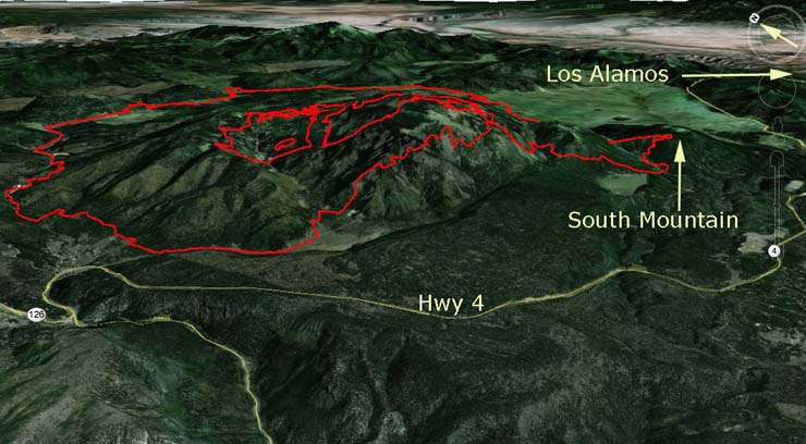
The map of the Thompson Ridge Fire above shows the perimeter at about 2 a.m. Sunday. The most recent fire spread was on the southeast side onto South Mountain, within about a mile of Highway 4.

The fire has grown to 20,687 acres and is listed at 40 percent containment. Firefighters have been completing firelines and burning out in the interior for the last couple of days. Saturday just before sunset they were firing out along a road on the southeast side, removing fuel between a planned line and the fire edge, when the fire spotted across the road and became established on the north side of South Mountain.

The plans now are to prepare for and then burn out between the southeast side of the fire and Highway 4.

Effective 6 a.m. today, June 9, 2013, New Mexico Highway 4 will be closed at the junction of State Route 126 to the junction of State Route 501. Residents in and around Sierra los Pinos are permitted entrance and exit along Highway 4 south to Jemez Springs. No traffic will be allowed to travel along Highway 4 east of Forest Road 10. Residents must show their identification to gain re-entry. There are no additional evacuations at this time. Evacuations remain in effect for Thompson Ridge, Rancho de la Cueva, and Elk Valley.

****

(UPDATE at 1 a.m. MT, June 9, 2013)

The Thompson Ridge Fire posted this “Urgent Update” at about 6 p.m. MT, June 8:

During burning operations this evening, the fire spotted across the fireline on the southeast side and established on South Mountain. Fire personnel are on scene evaluating containment options. Further updates as information becomes available.

Effective 0600 Sunday, June 9, 2013, New Mexico Highway 4 will be closed at the junction of State Route 126 to the junction of State Route 501.

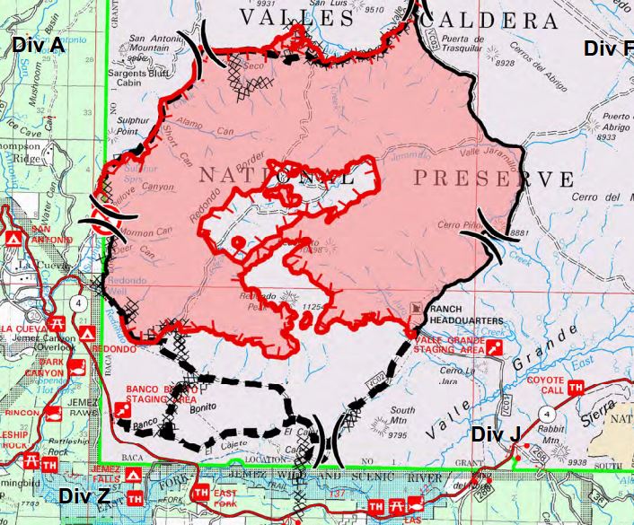
On the map of the Thompson Ridge Fire below, (created before the expansion onto South Mountain) the firefighters were most likely burning to remove fuel between the fire (the red area) and the black dashed line on the southeast side of the fire when it spread onto South Mountain, between the black dashed line and Highway 4.

Map Thompson Ridge Fire,
Map Thompson Ridge Fire, June 8, 2013 (click to enlarge)

The DC-10 air tanker and possibly other air tankers were dropping retardant on the Thompson Ridge fire Saturday afternoon, probably in the South Mountain area..

****
Continue reading “New Mexico: Thompson Ridge and Tres Lagunas Fires (updated June 9, 2013)”

Two fires in northern New Mexico

Tres Lagunas Fire
Tres Lagunas Fire, June 1, 2013. Photo by Jim Winchester, NM Environment and Energy Department.

Two fires in northern New Mexico are putting smoke into the air and making residents nervous.

Tres Lagunas and Thompson Ridge Fires
Tres Lagunas and Thompson Ridge Fires at about 10 p.m. MT, June 1, 2013.

The Tres Lagunas (Three Lagoons) Fire, 11 miles east of Santa Fe, was caused by a downed power line May 30 and has burned either 6,249 or 7,476 acres (both acreages appear on InciWeb). It is zero percent contained. Management of the fire was turned over to a Type 2 New Mexico Incident Management Team with John Pierson as Incident Commander. An Incident Command Post has been established at the Pecos National Historical Park nine miles south of the fire.

The Thompson Ridge Fire has burned about 1,700 acres 15 miles west of Los Alamos, north of Highway 4 and Jemez Springs, and is listed at 25 percent containment. Sunday at 3 p.m. there will be a public meeting at the Sierra de Los Pinos Fire Station 52.

New Mexico firefighter dies while on project work

A firefighter for the U.S. Forest Service in New Mexico collapsed and died May 5 while performing project work with his engine crew. The following message was distributed Monday, May 6, by Jeanne Higgins, Deputy Regional Forester for the USFS’ Southwestern Region.

It is with heavy hearts and great sadness that we share the tragic news of the death of Fallen Wildland Firefighter, Daniel Davidson.  Davidson, age 26, was working on project work near Mayhill, NM, on Sunday afternoon with two other engine crew members, when he collapsed. CPR was administered immediately, however when emergency personnel responded with the Life Flight helicopter, Davidson was pronounced deceased at the scene.The cause of Daniel Davidson’s death is under investigation.

Davidson, a U.S. Army veteran had served two tours in Afghanistan with the 10th Mountain Infantry Division. Following his tour in the Army, Davidson became a crew member of Engine 621 on the Sacramento Ranger District of the Lincoln National Forest.

Our sincerest condolences and heartfelt sympathy goes out to the family of Daniel. Additional information will be provided as it becomes available.

FEMA’s report can be found here.

Our sincere condolences go out to Mr. Davidson’s family and co-workers.

Thanks go out to Jeff