
Another fire, north of Beatty, OR, has burned more than 600 acres
Continue readingLabor Day fires of 2020 burned more of the Oregon Cascades than had burned in the previous 36 years combined
An analysis of the Labor Day 2020 wildfires in Oregon determined that the combination of high temperatures, unusually dry fuels, and strong winds occurring at the same time was unprecedented in the area.

That flammable combination led to an unprecedented number of acres burned in the Oregon Cascades, about 11 percent of the mountain range, and more than the previous 36 years combined.
Below is a summary of research published last month titled, “Compound Extremes Drive the Western Oregon Wildfires of September 2020,” by John T. Abatzoglou, David E. Rupp, Larry W. O’Neill, and Mojtaba Sadegh.
“Several very large fires in western Oregon spread rapidly during an unusually strong offshore wind event that commenced on Labor Day in 2020. The Labor Day fires burned more area of the Oregon Cascades than had burned in the previous 36 years combined and very likely exceeded the area burned in any single year for at least the past 120 years. The fires damaged over 4,000 structures, led to several fatalities, placed over 10% of the state’s residents under some level of evacuation advisory, and contributed to the hazardous air quality across the Northwestern United States.
“A compound set of weather-related factors leading up to and during the fires facilitated these extreme fires. Unusually warm conditions with limited precipitation in the 60-days leading up to the fires allowed for fuels to become particularly dry and combustible by early September. Downslope offshore winds materialized during September 7–9, 2020 across the Oregon Cascades bringing exceptionally strong winds and dry air that drove rapid rates of fire spread. While neither of these individual factors was unprecedented, the concurrence of these drivers created conditions unmatched in the observational record.”
The authors called that the “Plain Language Summary.” To drill down even more into Plain Language, the conditions in Oregon were hot, dry, and windy.
The Hot-Dry-Windy Index (HDWI) is a new tool for firefighters to predict weather conditions which can affect the spread of wildfires.
It is described as being very simple and only considers the atmospheric factors of heat, moisture, and wind. To be more precise, it is a multiplication of the maximum wind speed and maximum vapor pressure deficit (VPD) in the lowest 50 or so millibars in the atmosphere. It does not consider fuel moisture.
In preliminary data that had not been peer reviewed when we wrote about it February 20, 2019, the HDWI was far more useful than the Haines Index in predicting the growth of the Chetco Bar Fire which burned over 191,000 acres in Southwest Oregon in July, 2017.
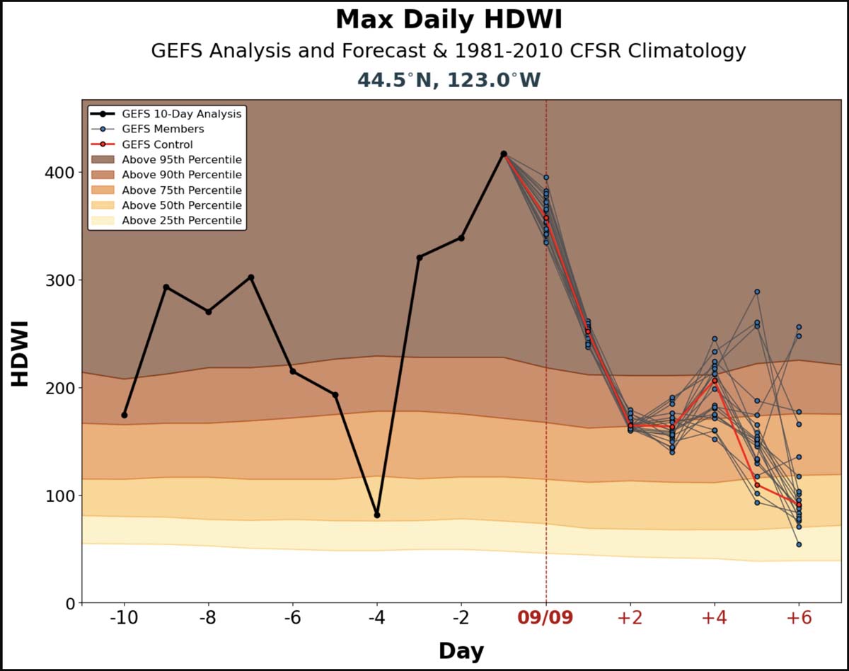
The HDWI for Oregon’s Willamette Valley was far above the 95th percentile September 6-9, 2020. During the 10 days prior to September 9 it was above the 90th percentile on nine days. The strong winds occurred September 7-9, and most of the growth of the Labor Day fires was during that period.

Thanks and a tip of the hat go out to Bob.
The Oregon Supreme Court ruled in favor of beavers — in 1939
A lawsuit between two landowners
Continue readingFEMA denied most Oregonians’ requests for wildfire disaster aid
Lower income applicants were about four times more likely to be denied than those with higher incomes
Continue readingManufactured housing units being built in Oregon as temporary housing for fire victims
FEMA has begun moving Manufactured Housing Units (MHUs) onto a newly constructed site in Mill City, Oregon that will provide temporary housing for qualified wildfire survivors and their families.
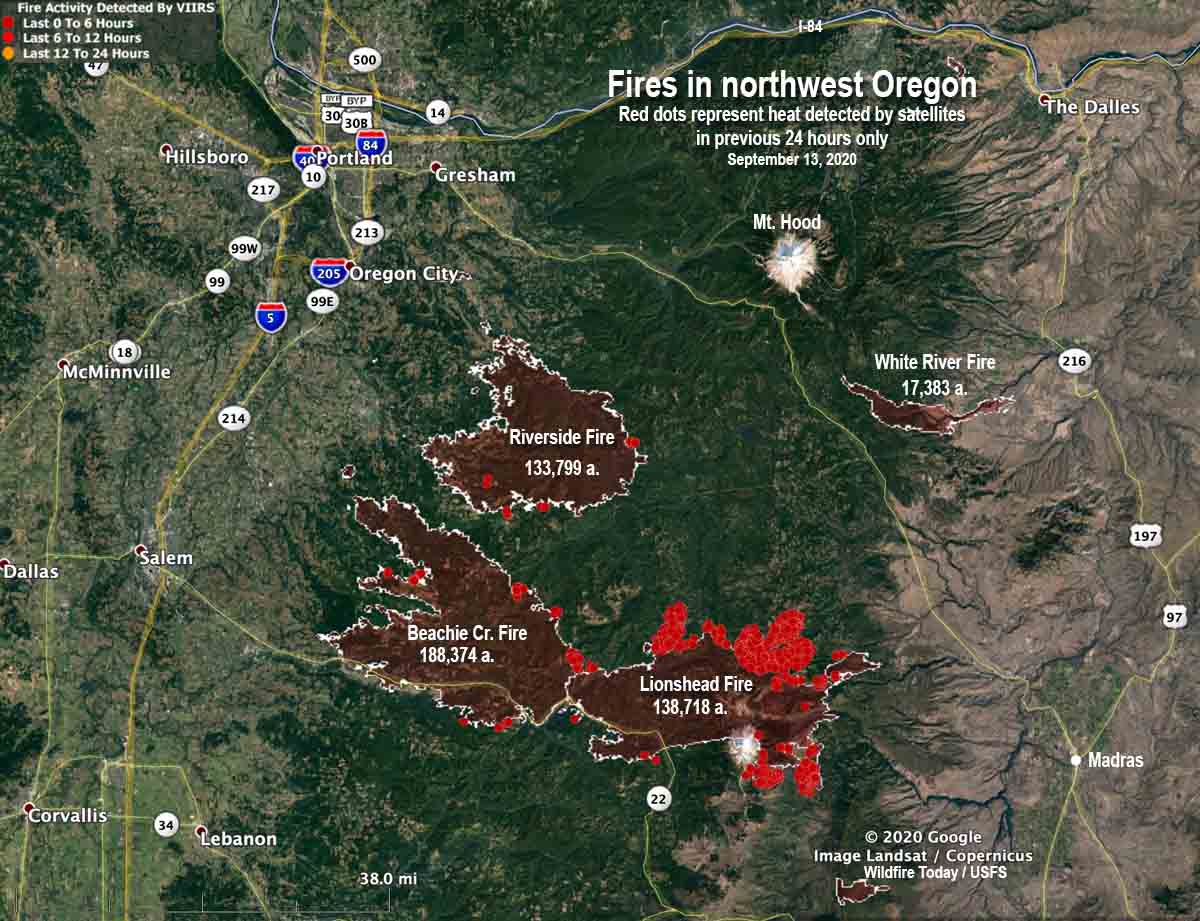
Several communities southeast of Salem along Highway 22 suffered severe impacts from the Beachie Creek and Lionshead Fires which grew large during the wind event of September 7 and 8, 2020. Some of the worst hit towns were Mill City and Gates.
Construction on the new Mill City site began earlier this month, with work completed ahead of schedule. The site is currently scheduled to receive 13 manufactured housing units (MHUs) and can accommodate up to 16 MHUs, providing necessary temporary housing for the qualified residents of both Linn and Marion counties.
As soon as all MHU are delivered and placed on site, each unit will be given a final inspection ensuring they are ready for occupancy, and families will be scheduled to move into their temporary homes.
To date, 85 families whose homes were severely damaged or destroyed by this year’s wildfires have been approved for temporary housing units. These units are placed in established RV parks or in FEMA constructed group sites.
In addition to Linn and Marion counties, FEMA’s Direct Housing mission is establishing temporary housing for qualified disaster survivors in Jackson and Lincoln counties in sites like the one in Mill City. Housing units are chosen by FEMA based on the survivor family composition and needs, as well as to ensure that requirements for access or functional needs are met.
Currently, 240 qualified families are scheduled to receive FEMA Direct Temporary Housing in the four counties. The current number of qualified families has fallen as many households that qualified for this assistance have located alternate temporary or permanent housing on their own.
Other programs for fire victims such as rental assistance may be available. Apply online at DisasterAssistance.gov, by downloading the FEMA app, or by calling the disaster assistance helpline at 800-621-3362 from 7 a.m. to 10 p.m. PDT, seven days a week.
BLM intends to give grazing permits to members of the Hammond family that served time for arson on public lands
Would grant access to 26,000 acres for $1.35/month per animal
Continue readingStudy found hazardous air quality conditions at fire camps in Oregon and California
Smoke exposure levels at the Creek Fire ranged from hazardous to unhealthy for 30 days
Continue readingPhotos of lookout tree on Ochoco National Forest in Oregon

Steve Stenkamp sent us photos of another lookout tree in Oregon. This one is on the Ochoco National Forest between Bend and John Day. Previously he documented one on the Deschutes National Forest in Central Oregon.
Years ago, in order to detect new ignitions of wildfires, land management agencies occasionally took advantage of tall trees on hilltops, building platforms near the top with ladders or other climbing aids below.
Mr. Stenkamp used his Phantom 3 Pro drone to get these photos.

“The unique feature is the ‘resting platform’ about 30 feet up,” Mr. Stenkamp said. “The ground cabin was moved to the Ochoco Guard Station when the lookout went out of service.”


Smokejumper hangs up in tree, falls during let down procedure
Suffered a serious back injury. Report is available.
Continue readingLawsuit filed to obtain documents about the Beachie Creek Fire in Oregon
Linn County requests records about the suppression of the fire
Continue reading