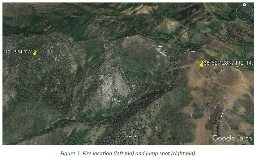
The Wildland Fire Lessons Learned Center has released a Facilitated Learning Analysis for an incident within an incident. Three of the seven smokejumpers that parachuted into the Miner Camp Peak Fire on July 29 east of Meadow, Utah were injured when landing. (Map) Two injuries were to the hand or wrist and the other was diagnosed at the scene as a broken collar bone or at least the potential for one.
The jumpers were evacuated by two helicopters, an air ambulance and a helicopter with hoist capabilities.
The jumpers received the resource order for the fire at 8:30 a.m. on July 29 while they were engaged in physical training at Winnemucca, Nevada. Since some of them “like to run trails in the surrounding area”, they did not get off the ground until 10:30. Due to the delayed departure, the distance they had to fly, and multiple issues related to fuel, the seven jumpers did not arrive on the ground at the fire until 5 p.m.
The incident occurred on the North Eden Fire which burned in Utah, Idaho, and Wyoming. No firefighters were injured.
Two engines burned on the North Eden Fire, August 16, 2018. Photo Credit: Brandon Everett, August 17, 2018.
A report has been released for an incident that occurred August 16, 2018 on the North Eden Fire. Two fire engines were burned over and destroyed but thankfully no one was injured. The fire eventually burned more than 13,000 acres in three states, Utah, Idaho, and Wyoming.
While a 5-ton 6X6 former military cargo truck converted for use as a fire engine was making a mobile attack on the fire, the driver, the only person in the vehicle, was operating a nozzle out of his window. The truck was in the green unburned area suppressing the active fire edge when the Low Air Warning System activated and it suddenly came to a stop. The driver was not able to move the vehicle. He got out, looked at the fire, then went back to retrieve his fire shelter. The truck would still pump water and he used a nozzle to wet the area around the immobile vehicle. Another engine, with the Fire Warden and a Fire Chief, came over to help and also sprayed water, but the fire closed in quickly
From the report:
…The Fire Warden used Heavy Brush 13 as a shield and sprayed down the 20-foot flames as the Fire Chief and Engine Operator ran to the black. The Fire Chief looked back and saw the Fire Warden “on his knees spraying into a wall of fire.”
Instincts and training kicked in. The Fire Warden recalls “I pulled them to the front of my truck, dropped the nozzle and told them to get into the black.” The Fire Warden then dropped the hose and also retreated into the black. He went approximately 15 feet where he joined the Fire Chief and Engine Operator. Flames were shooting out of the window of both trucks.
Within seconds, the tires of the trucks began exploding. From the time the Heavy Brush 13 was first reported down until the two trucks were engulfed in fire was a total of approximately three minutes.
There were no injuries.
One hour after burn over at 2:51 p.m.. This photo from the report shows the fuels and topography. Photo Credit: David Stacey, Woodruff Fire Department.
The report does not conclude exactly what caused the engine to become immobile, but pointed out that the 5-ton M928A2 has an air compressor that feeds three separate air tanks and components for the 6-wheel drive, as well as the parking and braking systems. Air brake systems require compressed air to work. If a loss of air occurs, the brakes will engage and the truck cannot be moved.
When received from the military the M928A2 has poly air lines which can be vulnerable to getting snagged and broken by brush, or melted by extreme heat from a nearby fire. Owners and operators using these on wildfires are advised to shield the lines with heat-resistant materials, relocate the lines, or replace them with more durable braided lines.
When Chief Royal Burnett retired in 1993 his employer’s agency was still called California Department of Forestry (CDF). At that time he was Chief of the Shingletown Battalion of the Shasta-Trinity Ranger Unit in Northern California. Still keeping his hand in the game, Chief Burnett recently spent some time analyzing how the disastrous Carr Fire spread into his town, Redding, California in July of 2018.
“I retained my interest in fire and fuel modeling after retirement”, the Chief said, “and with my fire geek friends I try to keep current.”
Chief Burnett told us that when he left the CDF he was qualified as a Type 2 Incident Commander, Type 1 Operations Section Chief, Type 1 Planning Section Chief, and Fire Behavior Analyst. He has lived Redding, California for 40 years.
The article below that the Chief wrote about his analysis of the Carr Fire is used here with his permission. A version of it has previously appeared at anewscafe.
The Carr Fire burned 229,651 acres and 1,079 residences, about 800 in the county area and the remaining number inside the city limits.
My friends Steve Iverson, Terry Stinson and I spent several days looking at the portion of the Carr Fire burn where it entered the city of Redding. This would be the Urban portion of the Wildland Urban Interface. That part of our town is newer construction, high-end subdivision homes built to California’s “SRA Fire Safe Regulations”. That is, non-flammable roofs, stucco siding, and all the rest of the State’s requirements. How did we lose almost 300 of them in one wildfire?
Royal Burnett
Many of these homes were built right on the edge of the Sacramento River canyon on finger ridges to maximize the view, or on the rim of side draws — anything to maximize the view from the property and capture the afternoon up-canyon wind flow. Most had large concrete patios and some had pools. There were no wooden decks extending over the canyon that I saw.
The Canyon is about ½ mile across where most of the houses burned, with the slope estimated at around 100 percent. The aspect where most of the homes burned is west-facing, meaning it catches the afternoon sun and preheats the forest fuels.
The canyon itself was predominantly filled with manzanita 12 to 15 feet high (75 percent) and the remainder was oak woodland, with scattered ceanothus brush and poison oak . The brush field was approximately 75 years old, having sprouted after Shasta Dam was completed in 1945. Available fuel loading ranged from 1 to 3 tons per acre in the oak woodland to 13 tons per acre in the heavy brush. All herbaceous material was cured and live fuel moisture was approximately 80 percent in manzanita — right at the critical level, which means it will burn as if its a dead fuel, not a live one.
The east side of the Carr Fire near Redding, California. Mapped August 26, 2017. Click to enlarge.
So, we’ve got a canyon filled with tons and tons of very flammable brush on an extremely steep slope with hundreds of very pricey homes perched on the rim, on a day when the temperature was 112 degrees and relative humidity was around 9 percent. To repeat a phrase from the 1960s, this was a “Design For Disaster”. (That was the title of fire training film describing the events of the Bel Air fire in Los Angeles County in 1961). [below]
We can determine how things burned by looking at burn patterns and other forensic evidence. For those who did this for a living its like reading a book. It was easy to figure out why the houses on the rim burned — they were looking right down the barrel of a blowtorch. Even though they had fire resistant construction, many had loaded their patios with flammable lawn furniture, tiki bars and flammable ornamental plants. Palm trees became flaming pillars, shredded bark became the fuse, junipers became napalm bombs.
Under current standards houses are build 6 to an acre; 10 feet to the property line and only 20 feet between houses. Once one house ignited, radiant heat could easily torch the next one.
We followed burned wood fence trails from lot to lot — wooden fences were nothing more than upright piles of kindling wood — and then into some ornamental shrubbery with an understory of shredded bark which torched and set the next house on fire. Then the fire progressed away from the canyon rim, not a wildland fire now, but a series of house fires, each contributing to the ignition of the next one.
We noted several, perhaps as many as a half dozen homes that burned from the ground up. Fire entered the building at the point where the stucco outer wall joined the slab and fire in the decorative bark was forced into the foam insulation and composition board sheeting under the stucco by the wind. Normally a fire in decorative bark is not a problem, it simply smolders. But in this case, where literally every burning ember was starting a spot fire and those spot fires were fanned by 100 mph in-draft wind, those smoldering fires were fanned into open flames which burned the homes. A simple piece of flashing could have prevented some of that loss.
We built homes to a fire resistant standard and then compromised them.
The fire hit Redding on an approximately two-mile front. It spotted across the Sacramento River in several locations and spread rapidly in the canyon, spawning numerous fire whirls. The updrafts caused the convection column to rotate, generating firestorm winds estimated at 140 mph. I’d guess most of the homes that were lost burned in the first hour after the fire crossed the river. The fire and rescue services were overwhelmed.
View from the Sacramento River in Redding north of the Sacramento River Trail Bridge. Google Street View. Click to enlarge.
The city of Redding allowed home construction on canyon rims, places that have proven to be fire traps over the years in almost every community where this construction has been allowed. Houses built in those exposed areas are similar to houses built in a flood zone. Its not a question IF they will burn, the question is When?
These subdivisions had limited egress. In one high-priced gated subdivision there is only one way in or out. Redding planners have seemingly ignored the lessons from past disasters like the Tunnel Fire in Oakland Hills in 1991 where 2,900 homes burned and 25 people died.
The city’s green belts have proven to be nothing but time bombs — fuel choked canyons that are a haven for her homeless. How many fire starts have we had in the canyon below Mercy Hospital, or in Sulfur Creek below Raley’s on Lake Boulevard? The homeless problem has exacerbated the fire problem. The fuels are there, the homeless provide the starts.
Even today, new subdivisions are being built overlooking the burned out canyons, looking across the rim at the ruins of homes burned in the Carr Fire.
The Sacramento River canyon will regrow, and it will be more flammable next time and stumps sprouting brush and noxious weeds will germinate in the burned area. The skeletons of the burned trees will become available fuel. In a couple of years the fuel bed will be more receptive to fire than it was before the Carr Fire.
If we don’t learn from our mistakes we are doomed to repeat them.
Thanks and a tip of the hat go out to Kelly. Typos or errors, report them HERE.
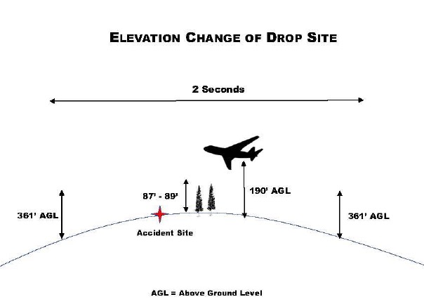
Draper City, Utah Battalion Chief Matthew Burchett was killed when a low drop uprooted an 87-foot tall tree that fell on him
Diagram from the Green Sheet.
(Originally published on FireAviation, September 14, 2018. Updated at 7:43 MDT September 14, 2018)
The California Department of Forestry and Fire Protection (CAL FIRE) has released what they call a “Green Sheet” report about the fatality and injuries that were caused by falling tree debris resulting from an air tanker’s retardant drop. The accident occurred on the Ranch Fire which was part of the Mendocino Complex of Fires east of Ukiah, California. The report was uploaded to the Wildland Fire Lessons Learned Center on September 13, 2018 exactly one month after the August 13 accident.
A firefighter from Utah, Draper City Battalion Chief Matthew Burchett, was killed when a low drop uprooted an 87-foot tall tree that fell on him. Three other firefighters had different assortments of injuries from sheered-off trees and limbs, including broken ribs, deep muscle contusions, ligament damage to extremities, scratches, and abrasions.
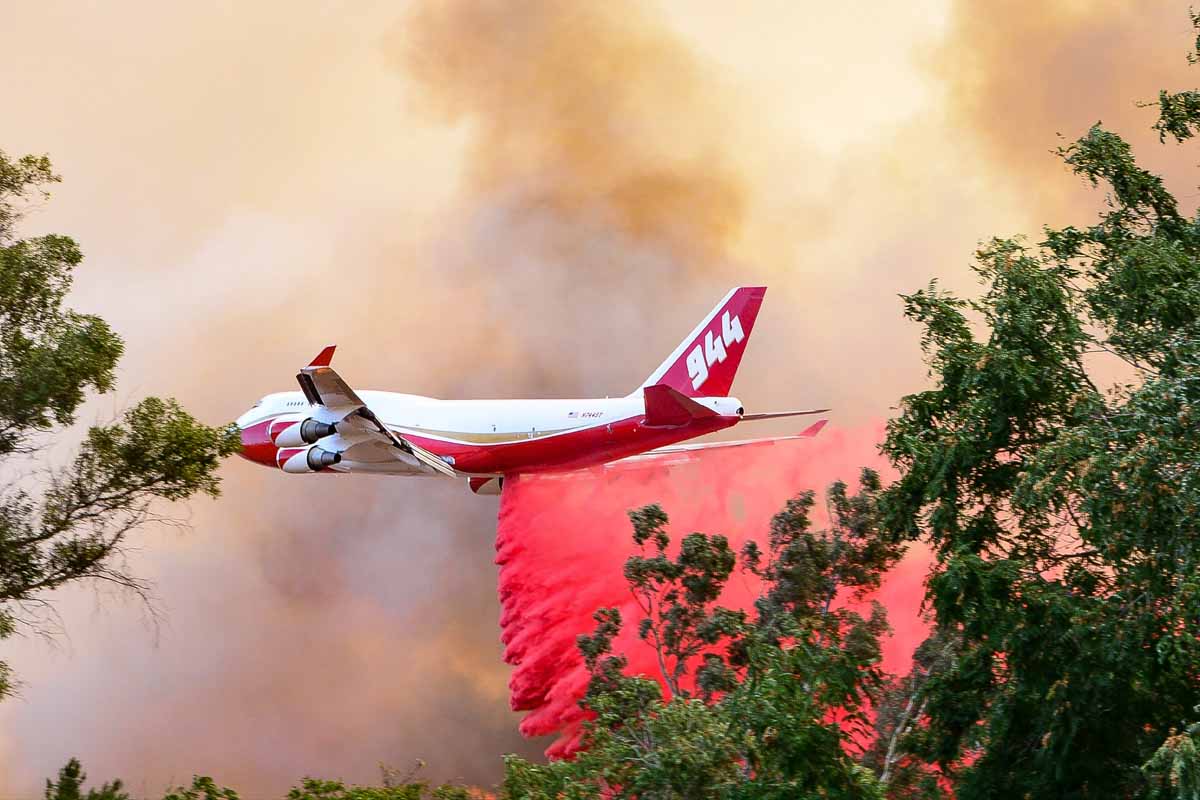
File photo: The 747 SuperTanker drops on the Palmer Fire south of Calimesa and Yucaipa in southern California, September 2, 2017. Photo by Cy Phenice, used with permission.
Standard procedure is for firefighters to leave an area before an air tanker drops. The report said the personnel on that Division were told twice that day to not be under drops — once in a morning Division break-out briefing, and again on the radio before the fatal drop and three others from large air tankers were made in the area. It was not confirmed that all supervisors heard the order on the radio to evacuate the drop area.
One of the “Incidental Issues / Lessons Learned” in the report mentioned that some firefighters like to record video of air tanker drops:
Fireline personnel have used their cell phones to video the aerial retardant drops. The focus on recording the retardant drops on video may distract firefighters. This activity may impair their ability to recognize the hazards and take appropriate evasive action possibly reducing or eliminating injuries.
The air tanker that made the drop was T-944, a 747-400 that can carry up to 19,200 gallons. Instead of a more conventional gravity-powered retardant delivery system, the aircraft has pressurized equipment that forces the retardant out of the tanks using compressed air. This is similar to the MAFFS air tankers. When a drop is made from the recommended height the retardant hits the ground as a mist, falling vertically, rather than the larger droplets you see with a gravity tank.
In this case, according to the report, the drop was made from approximately 100 feet above the tree tops. The report stated:
The Aerial Supervision Module (ASM) identified the drop path to the VLAT by use of a smoke trail. The VLAT initiated the retardant drop as identified by the smoke trail. Obscured by heavy vegetation and unknown to the VLAT pilot, a rise in elevation occurred along the flight path. This rise in elevation resulted in the retardant drop only being approximately 100 feet above the treetops at the accident site.
When a drop is made from a very low altitude with any air tanker, the retardant is still moving forward almost as fast as the aircraft, as seen in this drop. If it is still moving forward there will be “shadows” that are free of retardant on the back side of vegetation, reducing the effectiveness of the drop. From a proper height retardant will gradually slow from air resistance, move in an arc and ideally will be falling gently straight down before it hits the ground. Another example of a low drop was on the Liberty Fire in Southern California in 2017 that dislodged dozens of ceramic roofing tiles on a residence and blew out several windows allowing a great deal of retardant to enter the home.
We reached out with some questions to Global Supertanker, the company that operates the 747 Supertanker, and they gave us this statement:
We’re heartbroken for the families, friends and colleagues of Chief Burchett and the other brave firefighters who were injured during their recent work on the Mendocino Complex Fire. As proud members of the wildland firefighting community, we, too, have lost a brother.
On August 13, 2018, Global SuperTanker Services, LLC acted within procedural and operational parameters. The subject drop was initiated at the location requested by the Aerial Supervision Module (ASM) after Global SuperTanker Services, LLC was advised that the line was clear.
The former President and CEO of the company, Jim Wheeler, no longer works there as of September 1, 2018. The company is owned by Alterna Capital Partners LLC, of Wilton, Conn.
(Updated at 7:43 MDT September 14, 2018 to include the statement from Global Supertanker that we received at 7:35 p.m. MDT September 14, 2018)
CAL FIRE has released a “Green Sheet” report on the accident that occurred August 1, 2018
The California Department of Forestry and Fire Protection (CAL FIRE) has released a Green Sheet report about the rollover of a dozer that occurred August 1, 2018 on the Carr Fire west of Redding, California.
Below are excerpts from the 14-page report:
“At approximately 7:00 AM on Tuesday, July 31, 2018, two CWN bulldozers (DOZ1 and DOZ2) were 24 hour resources assigned to Branch III, Division D on the Carr incident. DOZ1’s operator (OP1) had been assigned to the same area on the previous 24-hour operational period (south of HWY 299E on County Line Road) and worked the night shift (7:00 PM to 7:00 AM). OP1 had 4 years of bulldozer operating experience and at least 17 years in the logging industry. OP1 had used the bulldozer extensively in Sonoma and Napa counties in the Fall of 2017.
[…]
“At approximately 12:30 AM, STL1 looked toward DOZ1, located up the spur ridge and observed DOZ1 close to the steeper east aspect of the spur ridge. From STL1’s vantage point, DOZ1 was facing him and appeared to be tilted to the right at approximately 40-45 degrees. STL1 observed DOZ1 attempt to climb back to the center of the spur ridge in reverse. While DOZ1 backed, STL1 further observed the front of DOZ1 abruptly rotated 90 degrees to the left and the front of the dozer lift into the air. DOZ1 then lost traction and slid backwards downhill, at which time STL1 saw DOZ1 roll twice, end over end, before he lost sight of it down the slope. STL1 could hear DOZ1 continue to roll down the slope, and then stop. STL1 went to the edge of the slope where DOZ1 left the ridgetop, and could see DOZ1 approximately 300 feet downslope.
“At approximately 12:32 AM, STL1 notified Branch II (t) of the accident and his intention to proceed to DOZ1 to ascertain injuries and needs. STL1 contacted DOZ2 to cease operations and then proceeded to DOZ1’s location. Branch II Safety Officer and Division C Fireline Medics responded to the accident site. Carr Communications was notified of the accident at 12:34 AM by Branch II (t).
“While walking downslope to DOZ1, STL1 heard the engine speed fluctuating up and down. STL1 found the dozer upright on its tracks with the cab still intact. STL1 observed movement inside the bulldozer cab. DOZ1 appeared to be stable and STL1 boarded the dozer on the uphill (right) side. The right cab door was jammed and would only open a couple of inches. STL1 contacted OP1 and did a quick visual assessment. OP1 suffered injuries to the head but was alert and oriented.
“At approximately 12:35 AM, STL1 updated Branch II (t) of OP1’s condition via radio. Branch II (t) advised STL1 to follow the “Incident Within an Incident” protocol in the Incident Action Plan. OP1 self-extricated through the left cab door. With OP1 sitting on the ground, STL1 performed a thorough secondary patient assessment. A night hoist capable helicopter was requested due to mechanism of injury, patient location, and extended ground transport time to a medical facility. A California National Guard night vision equipped 24-hour helicopter medivac resource, assigned to the incident, responded from Redding Helibase and an Advanced Life Support ground ambulance was dispatched to Hwy 299E and County Line Road (Buckhorn Summit) from their staging area in west Redding.
“Division C Fireline Medics arrived at the accident site at 1:35 AM. Due to a heavy smoke inversion, the helicopter experienced difficulty accessing the accident site and at 2:01 AM, Division C Medics cancelled the helicopter and walked OP1 out to meet the ground ambulance. OP1 was transferred to the ALS ambulance at 2:43 AM and began transport to Mercy Medical Center with a 2-hour estimated time of arrival…”
The rollover path of the dozer accident on the Carr Fire, August 1, 2018. Image from the CAL FIRE Green Sheet.
The six firefighters on the Mendocino Complex of Fires in Northern California had to run for a mile through unburned vegetation when an unexpected wind shift caused explosive fire growth
The following “72-Hour Report” was distributed by the Wildland Fire Lessons Learned Center August 28, 2018 for an incident that occurred August 19, 2018 on the Mendocino Complex of Fires in Northern California.
THE FOLLOWING INFORMATION IS PRELIMINARY AND SUBJECT TO CHANGE
Location: Ranch Fire, Mendocino Complex, east of Ukiah, CA Date of Occurrence: Sunday, August 19, 2018 Local Agency Administrator: Ann Carlson, Mendocino Forest Supervisor Activity: Wildland Fire Suppression Number of Injuries: 6 Number of Fatalities: 0 Property Damage: Radios, packs, 2 vehicles with paint blistering.
SUMMARY
On August 19, 2018, six firefighters received injuries when the fire crossed the dozer line in multiple locations and cut them off from their planned egress. At the time of the incident, firefighters were en-gaged in firing operations off a dozer line near the division break between Hotel and Juliet on the Ranch Fire of the Mendocino Complex.
CONDITIONS
Information from RAWS nearby around the time of this incident, showed temperatures at 93.3 Fahren-heit, RH 11.3%, and winds at 6.6 mph with gusts to 13.3 mph.
NARRATIVE
The Mendocino Complex consisted of the Ranch and River fires that started on July 27th. The fires experienced significant growth during the first ten days, growing 30,000 acres on August 3rd, 40,000 acres on August 4th and 50,000 acres on August 5th. Up until August 19th, the fire growth had been steadily moving both south/southeast and north/northeast. Most days experienced warming and drying trends with very poor recoveries and critically low fuel moistures and afternoon relative humidities near single digits. Steep terrain, poor ventilation, fire intensities and long travel times made it difficult to insert crews and utilize aircraft in certain areas of the fire.
On August 19th, the plan for the fire’s northeast flank was to secure dozer line north of DP25 near the division break in Branch II with a firing operation. Resources from other divisions were brought over to help with the operations. These resources included federal and local fire resources and strike teams from the Los Angeles Fire Department and CAL FIRE. After arriving near the drop point, the personnel staged their engines and vehicles, reconfigured, and were split into two modules to support burning operations and hold the line along a Forest Service road and the dozer line.
During the burnout operations, a sudden wind shift and explosive fire growth happened and at about 1733, personnel were cut off from their escape routes. Most of the firefighters were able to move back to their vehicles to exit the area. However, six individuals farther down the dozer line were forced to run in front of the advancing flame front, through unburned fuels to a nearby dirt road for approximately one mile before they were picked up and transported for treatment. Five Los Angeles Fire Department firefighters and one CAL FIRE firefighter were injured. Two unoccupied CAL FIRE emergency crew transports parked in the vicinity sustained damage from the fire when it jumped containment lines.
Injuries include 1st and 2nd degree burns and a dislocated shoulder.