Two wildfires east of Phoenix grew rapidly on Friday

South of Globe, Arizona

5:31 p.m. MDT June 5, 2021

Mescal Fire
According to the San Carlos Apache Tribe Emergency Response Commission, evacuations have been ordered for Coyote Flats Peridot Heights, the San Carlos High School Area, and all residents along Route 3.

The fire has burned more than 25,600 acres and has 400 personnel assigned, led by Southwest Area Incident Management Team 5.

(To see all articles on Wildfire Today about these fires, including the most current, click here.)

Telegraph Fire
The incident management team (IMT) announced the estimated size has been updated to 25,000 acres. A Type 1 IMT has been ordered. The Sheriff’s Office has placed the towns of Superior and Top-of-the-World in “SET- Be Alert” status due. This means there is significant danger in the area, threatening approximately 150 residents — be ready to evacuate if notified from public safety officials. This is NOT an evacuation notification.

An estimated 150 personnel are managing the fire including 3 hand crews and 5 engines, with additional support from the State of Arizona, Gila District Bureau of Land Management, and Pinal County. A Type 1 Incident Management Team has been ordered.

Smoke
Below is the smoke forecast for Saturday evening at 8 MDT. Heavy smoke from the Mescal and Telegraph Fires is projected to move east into Southern New Mexico and Texas toward El Paso and Juárez.

Smoke Forecast Mescal and Telegraph Fires
Smoke Forecast for 8 p.m. MDT June 5, 2021. Heavy smoke from the Mescal and Telegraph Fires is projected to move east into Southern New Mexico.

12:19 p.m. MDT June 5, 2021

map Telegraph & Mescal Fires Arizona
Map, showing the locations of the Telegraph & Mescal Fires in Arizona.

Two wildfires east of Phoenix, Arizona were very active Friday, exhibiting extreme fire behavior while pushed by strong winds.

Mescal Fire

The Mescal Fire 60 miles east-southeast of Phoenix and 12 miles southeast of Globe spread several miles to the east and northeast Friday, pushed by strong winds gusting to 34 mph, coming to within less than two miles of the north shore of San Carlos Reservoir. The west side of the fire continued to move to the west. (see map above)

The incident management team reported Friday that it had grown to 7,900 acres since it started June 1. Heat detected by satellites indicates that with the growth late Friday and into the night it could be two to three times that size, but mapping aircraft were not available Friday night to update the mapped perimeter.

Telegraph Fire

The Telegraph Fire is 35 miles east-southeast of Phoenix and 18 miles southwest of Globe. As this was written before noon on Saturday it had been burning approximately 24 hours. Officially it is 3,500 acres but with recent growth could be more than 5,500 acres. The Pinal County Sheriff’s Office placed the town of Superior in “SET-Be Alert” status at about 11 a.m. Saturday, meaning there was significant danger from the fire, but evacuations had not been ordered at that time. (Sign up for alerts.)

Fire officials said they expect it to move to the north and east Saturday with extreme fire behavior.

Telegraph Fire Arizona
Telegraph Fire, June 4, 2021. InciWeb photo.

Weather

The weather forecast for the area is for hot, dry, and breezy conditions to persist through the weekend, with wind gusts up to 30 mph, daytime humidities in the single digits, and high temperatures near 100. These conditions will make it a challenge for firefighters to make a lot of progress toward containing the fires. A Red Flag Warning is expected to be in effect Saturday afternoon.

Telegraph Fire Arizona
Telegraph Fire, June 4, 2021. InciWeb photo.

What you can do to prepare for wildfire smoke this summer

Certain type of air cleaners and masks can be helpful

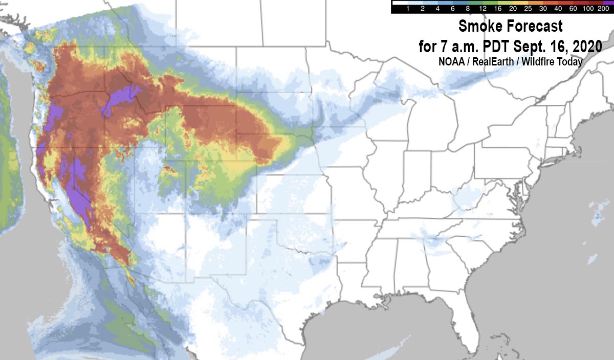
Smoke Forecast for 7 a.m. PDT Sept. 16, 2020
File image — Wildfire smoke Forecast for 7 a.m. PDT Sept. 16, 2020.

In August and September of last year some areas in the western states were under smoke advisories for weeks at a time due to numerous wildfires. If the weather in the coming months is hot, dry, and windy, and with the vegetation being dried by the multi-year drought, there could be multitudinous large fires producing conditions at least as smoky as 2020, or worse.

Smoke can have serious adverse effects on those who have asthma, COPD, heart disease, diabetes, and other chronic conditions or acute infections such as COVID-19.  Older people, pregnant women, and young children can also be at risk.

It is not practical for most of us to move to a different part of the country to find better air quality, but there are some measures that can be taken to reduce the concentration of the tiny smoke particles inside the home that can cause problems when they get into the lungs.

Closing windows will not keep smoke out of a structure. However, if you have a good quality air filtration device, the air inside the house should be better than what is outside with the windows closed. When the smoke is dense, it would be difficult for one portable air cleaner with a HEPA filter to treat the entire home, so if you only have one, put it where you spend the most time, such as the bedroom.

If you have a central air conditioner or heating system, slide-in filters can be purchased that are rated to remove very small particles like smoke and pollen. Filters are rated under various criteria — one is MERV (Minimum Efficiency Reporting Value). The higher the MERV number the better it is at removing the small particles. And medium-efficiency MERV filters in the 8 to 13 range can remove about 90 percent or more of these.

You can also tape a MERV 8 to 13 filter on a box fan and it will do a pretty good job of removing smoke in a small room. Unfortunately not all filter manufacturers use the MERV rating system. The New York Times reports that Filtrete, one of the larger filter companies, said their rating system, MPR, can be translated to MERV. “Filtrete said MPR 1900 is equivalent to MERV 13, MPR 1500 to MERV 12, and MPR 1000 to MERV 11.”

Respirator masks used during the pandemic, such as well-fitting N95, KN95 and KF94 masks, can offer protection when outside. A simple cloth mask can’t filter the PM 2.5 smoke particles.

Apps for smart phones can provide up to date air quality information. Examples include WeatherCAN and AQHI Canada in Canada, and AirNow and SmokeSense in the U.S.

Satellite photo smoke wildfires
File image — Satellite photo showing smoke from wildfires at 5:17 p.m. PDT September 11, 2020.

Large wildfires in Manitoba prompt smoke advisories

Manitoba fires map
Map showing the locations of wildfires in Southern Manitoba at 5:12 a.m. CDT May 18, 2021. Based on heat detected by satellites.

Multiple wildfires in Southern Manitoba grew large Monday pushed by strong winds while the temperature was high and the relative humidity was low. The smoke being produced by the blazes prompted Environment Canada to issue multiple special air quality statements Monday evening.

“Localized areas of smoke are creating reduced visibilities and poor air quality down wind of fires,” the agency said in the statement.

Satellite photo of smoke from Manitoba wildfires
Satellite photo of smoke from Manitoba wildfires, May 17, 2021.

The areas under the air quality statement as of Monday evening include:

  •  Whiteshell – Lac du Bonnet – Pinawa
  •  Arborg – Hecla – Fisher River – Gypsumville – Ashern
  •  Bissett – Victoria Beach – Nopiming Provincial Park – Pine Falls
  •  Brandon – Neepawa – Carberry – Treherne
  •  Dauphin – Russell – Roblin – Winnipegosis
  •  Dugald – Beausejour – Grand Beach
  •  Grand Rapids – Waterhen
  •  Selkirk – Gimli – Stonewall – Woodlands
  •  Ste. Rose – McCreary – Alonsa – Gladstone

Four 10-person teams of firefighters are being brought in from Ontario to assist, while Quebec sent two air tankers and a bird dog aircraft.

Ontario firefighters en route Manitoba fire
Ontario firefighters en route to assist with wildfires in Manitoba May 15, 2021. Photo by Ontario Ministry of Natural Resources.

The EA044 fire 23 Km (14 miles) west of Gypsumville seen on the map above is very close to another much larger fire. They may be all one fire separated by an area of light vegetation that cooled in between heat-detecting satellite overflights. If they are one, they cover an area of approximately 52,500 hectares (130,000 acres). About 28,300 hectares (70,000 acres) burned at that location Monday during the strong winds.

Below are forecasts produced by FireSmoke Canada for the distribution of wildfire smoke on Tuesday and Thursday. The circles with numbers indicate multiple fires at each location.

Forecast for smoke from Arizona’s Tussock Fire

Tussock Fire smoke plume May 10
Tussock Fire predicted smoke plume. May 10. Arizona Department of Environmental Quality.

The Arizona Department of Environmental Quality expects that smoke from the Tussock Fire will generally disperse to the east Monday and Tuesday. The fire is 27 air miles northwest of the northern Phoenix suburbs.

Below is their prediction issued at 9:47 a.m. on Monday May 10, 2021:

“[Monday] is expected to be another windy day, with south-southwest winds in the 10-20 mph range. Smoke is forecast to rise and disperse toward the east-northeast. Smoke may move over Camp Verde, Payson, and Winslow; however, smoke is expected to be elevated off the ground. Some smoke may drop down the backside of the Bradshaws Mountains this afternoon and into Bumble Bee, Cordes Lakes, Cleator, and Mayer, but impacts are expected to be short-lived.

“[Tuesday], as high pressure builds into the region, smoke is forecast to rise and disperse toward the east-southeast, with some smoke moving over the far north portion of the Phoenix Valley. This smoke is expected to be elevated well off the ground, so not forecasting any smoke impacts to the Valley. With that said, Anthem, New River, and Cave Creek may briefly smell smoke, especially in the late evening on Tuesday.”

The forecast below for Arizona is for 6 p.m. MDT May 10, 2021, produced by NOAA.

Smoke Forecast, 6 p.m. MDT May 10, 2021 Arizona Tussock Fire
Smoke Forecast for Arizona, 6 p.m. MDT May 10, 2021. NOAA.

Two women killed in I-15 accident as smoke obscured the highway

In Northern Montana north of Conrad

 I-15 North of Conrad, MT fire
Heat from a fire detected by a satellite near I-15 north of Conrad, MT, May 3, 2021 near the site of the fatal crash as reported by the Montana Highway Patrol.

A tractor-trailer that slowed as it traveled through a cloud of smoke from a controlled burn near the highway led to a chain-reaction crash on Interstate 15 near Conrad May 3, killing two young women from Columbia Falls.

A chain reaction series of crashes began when a tractor trailer slowed to 25 mph as it entered the smoke according to the Montana Highway Patrol (MHP). A second tractor trailer plowed into the first, then a sedan with the two women hit the second truck and a fourth vehicle, a sedan, hit the vehicle with the two women, who died at the scene. Four people in the fourth vehicle were injured.

The crash occurred at approximately 1:15 p.m. on I-15 at mile marker 344, about five miles north of Conrad, 0.78 mile south of Ledger Road (MT 366).

During a 2:54 p.m. MDT overflight on the day of the crash a satellite detected heat from a fire just west of the location of the crash reported by the MHP. According to Google Earth imagery virtually everything within a mile of the site, other than roads, is agricultural fields, including the location of the detected fire. It appears likely that the controlled burn was from agricultural or debris burning, rather than a prescribed burn used by land managers to reduce hazardous fuels or restore fire to a fire dependent ecosystem.

Thanks and a tip of the hat go out to Dick.

Mass Bird Die-Off Linked to Wildfires and Toxic Gases

Using observations from crowdsourced science and weather location data, researchers concluded that wildfires caused a mass die-off of birds in the western and central United States in 2020.

By Joshua Rapp Learn

After an abnormally large number of migratory birds turned up dead in people’s backyards in Colorado and other parts of western and central U.S. states, locals began to document their observations on a crowdsourced science platform called iNaturalist. Within the app, a special project was set up specifically for this die-off, which occurred in August and September 2020, so that records of the dead birds could be compiled together.

Around the same period as the birds’ deaths, more than 3 million hectares (7.8 million acres) of land burned, which resulted in habitat loss and the emission of toxic compounds that threaten the health of both avian species and humans. In addition, snowstorms struck parts of the Northwest in early September while these birds were in the midst of their annual migration. Some areas experienced temperature drops of as much as 40°C (72°F) in just a few hours.

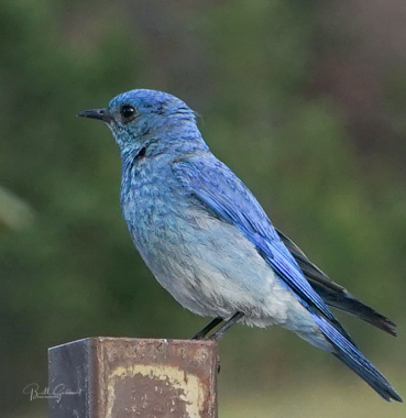
Mountain Bluebird, male
Mountain Bluebird, male. Photo by Bill Gabbert.

Researchers heard of this die-off event and wanted to see whether there was a link between the birds’ deaths and the other major events (wildfires and snowstorms) occurring in the United States at the time. In a new study published in GeoHealth, Yang et al. used the iNaturalist data, which included recordings of a number of migratory species such as warblers, geese, hummingbirds, swallows, flycatchers, and sparrows. The scientists also studied map readings that showed where observations were taken on iNaturalist to compare the locations of the birds’ deaths with the locations of the wildfires and storms.

Their findings were starkly clear. “The wildfire and also the toxic air were the two factors that influenced the birds’ mortality,” said Anni Yang, a postdoctoral fellow in spatial ecology at Colorado State University and one of the study’s authors. There was a strong correlation between the observations of dead birds and wildfires and the toxic gases they produced, but not with the early winter storms.

“The birds are sensitive to the environment,” Yang said. The respiratory system of avian species in particular easily can be damaged by air pollution. Although wildfires have always occurred and birds have evolved to cope with them in some measure, the combination of climate change and decades of fire suppression in parts of the United States has led to fires that burn far hotter and larger than fires that burned in centuries past. The larger fires could cause problems that birds nowadays aren’t capable of dealing with.The researchers also discovered that there were some differences in local areas. In parts of California, for example, more bird deaths occurred farther from the wildfires. The reason could be secondary impacts of the fires affecting humidity levels, which could lead to the deaths of birds in hot, humid air over the ocean.The researchers also noticed other trends. Land cover had an impact on bird deaths; the data showed that more birds died in urban areas. According to the authors, the reason could be known issues that affect birds, such as building strikes. But Yang noted that this correlation may be slightly biased because of quarantining due to the pandemic. In other words, people were spending more time in urban areas and perhaps paying more attention to dead birds around their homes, which inadvertently may have boosted the numbers in cities compared with rural areas.Yang also suggested that the lack of correlation between bird deaths and the snowstorms could be explained by shortcomings in the crowdsourced science application. In that case, fewer people may have been going outside during the bad weather, which could translate to fewer observations of dead birds.

Yang said other local factors might have played roles in the deaths of some species. The researchers looked at all bird deaths equally, but different species could be affected in different ways by climate events like wildfire smoke or a snowstorm.

Rongting Xu, an ecosystem modeler at Oregon State University and another of the paper’s authors, said that it would be great to run the same study over multiple years, comparing the summer of 2020 with previous summers, for example, to see whether wildfires or early snowstorms in other years caused similar die-offs. Such long-term examinations could also reveal whether factors like climate change are playing a role in bird deaths, she said. (GeoHealthhttps://doi.org/10.1029/2021GH000395, 2021)

—Joshua Rapp Learn (@JoshuaLearn1), Science Writer


This article first appeared at EOS, Science News by AGU.
Citation: Learn, J. R. (2021), Mass bird die-off linked to wildfires and toxic gases, Eos, 102, https://doi.org/10.1029/2021EO156447. Published on 26 March 2021.