More homes and acres burn in Brian Head Fire in southwest Utah

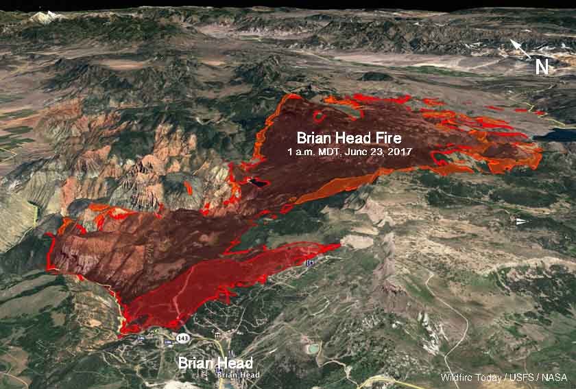
Above: A 3-D map of the perimeter of the Brian Head Fire as of 10:30 p.m. MDT June 23, 2017.

The Brian Head Fire in southwest Utah continued to burn structures Friday. At the end of the day the Incident Management Team reported that 26 have been destroyed, double the number from Thursday.

The fire also blackened an additional 10,000 acres bringing the total up to 37,560.

As of Saturday night the fire had spread to the south approaching the closed Highway 143 in several places but has not crossed it. Most of the expansion on Saturday was on the south and southeast sides.

Tim Roide’s Great Basin Type 2 Incident Management Team is not providing a great deal of information about the fire, but as of Friday evacuations were still in effect in several areas. They have been producing a daily update, but on Inciweb the Team suggests searching for the generic hashtag #BrianHeadFire to find information provided by others.
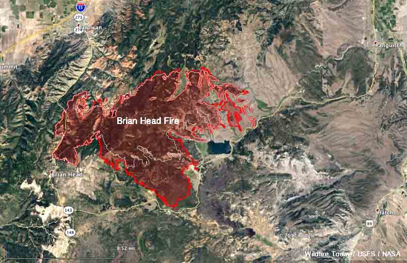
map Brian Head Fire
Map of the perimeter of the Brian Head Fire as of 10:30 p.m. MDT June 23, 2017. Click to enlarge.

Firefighting resources assigned to the fire include 10 Type 1 hand crews, 13 Type 2 hand crews, 4 Type 1 helicopters, 5 other helicopters, 40 engines, and a total of 836 personnel.

Be sure and click on the photos below a couple of times to see larger versions… especially the one on the left.

Brian Head Fire in Utah burns 13 homes

The fire doubled in size between Wednesday night and Thursday night.

Strong winds on Thursday spread the Brian Head Fire much farther to the south and east, adding another 16,800 acres, bringing the total to 27,700. The Utah Department of Natural Resources said 13 homes and 8 outbuildings have been destroyed in the communities near Brian Head, Utah as the fire spread down Clear Creek.

Southern Utah University is opening their dorms to displaced residents of the fire ravaged town of Brian Head. The University will have room for up to 60 people. Those interested can call George Colton, Red Cross Site Director, at (435) 879-9033.

map Brian Head Fire Utah
3-D map of the Brian Head Fire as of 1 a.m. MDT June 23, 2017.

Highway 143 is closed from the cemetery in Parowan to milepost 50 outside of Panguitch.

The weather for Friday and Saturday should bring temperatures around 70, relative humidity in the low teens, and winds out of the northwest to northeast at 5 to 10 mph with gusts in the high teens. There will be virtually no humidity recovery at night; it will be no higher than the 20’s for the next two nights. For Sunday through Friday the nighttime humidity will be below 40 percent and in the teens during the day. This could allow the fire to remain active 24 hours a day. Monday through Wednesday will bring 20 mph winds, which could be problematic for firefighters.

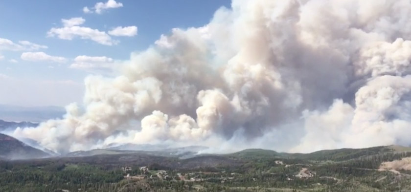
Brian Head Fire, from video uploaded to Inciweb June 21, 2017.

Wildfire forces evacuation of Brian Head, Utah

Above: The Brian Head Fire at Brian Head, Utah. Photo by Iron County Sheriff’s Office, posted June 17, 2017.

The Brian Head Fire has burned at least one home in the town by the same name, which is 12 miles east of Cedar City, Utah. As of Saturday evening the fire had burned about 957 acres on the north side of the town near the Dixie National Forest. Multiple structures are threatened.

The fire was reported at 12:20 p.m. on June 17 and caused the evacuation of all 500 residents of the town.

A Type 3 Incident Management Team was due to arrive Saturday evening, and a Type 2 Team is expected at mid-day on Sunday.

Brian Head Fire 3-d map
A 3-D map showing the approximate location of the Brian Head Fire as of 4:30 a.m. MDT June 18, 2017.
Brian Head Fire map
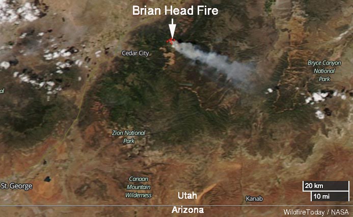
Satellite photo showing smoke from the Brian Head Fire June 17, 2017.

An inversion early Sunday morning trapped smoke, degrading visibility to the point where firefighting aircraft could not be used, but by noon MDT two Air Tractor 802A Single Engine Air Tankers were working the fire. They were reloading at Cedar City 12 miles away so they undoubtedly had short turnarounds in spite of the 4,000-foot climb from the air tanker base to the fire.

Brian Head Fire air tanker
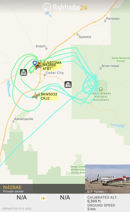
Flight paths of a Single Engine Air Tanker working the Brian Head Fire at 12:50 p.m. MDT June 18, 2017.

The wind on Saturday was from the northwest, but on Sunday it shifted to come out of the north. As you can see in the image above, at about noon on Saturday the flight paths of one of the Single Engine Air Tankers were concentrated south of Brian Head, on the west side of Cedar Breaks National Monument.

The wind on Saturday is predicted to be out of the north at 8 to 10 mph with gusts to 13. The relative humidity should be in the mid-20’s and the temperature will be in the high 60’s. The coolish temperatures are due to the altitude — 8,000 to 10,000 feet above sea level in the fire area, which is about 4,000 feet higher than Cedar City.

The impressive video below posted by the Iron County Sheriff Office shows an air tanker dropping retardant apparently into heavy smoke. Perhaps there were structures or firefighters, or both, threatened in that area.

One option for removing pinyon/juniper

There are many different types of machines that can reduce vegetation to much smaller pieces or chips. Here is one variation being used in Utah.

Rainfall in western states slows wildfire season in many areas

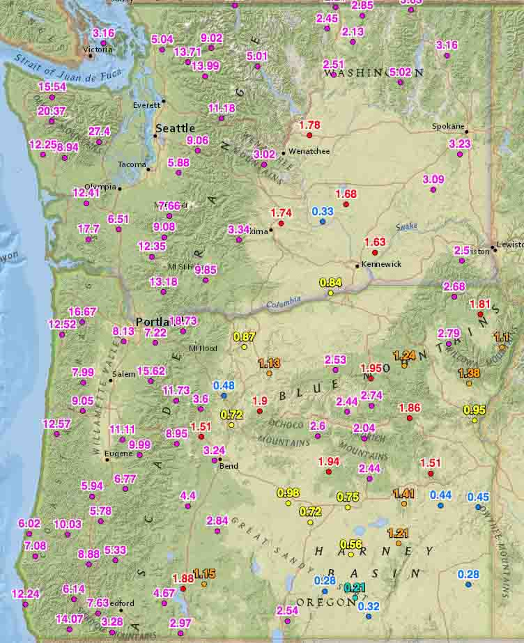
Rainfall last 2 weeks washington oregon
Rainfall last 2 weeks, Washington and Oregon

Rainfall over the last two weeks has slowed or in some cases, ended the wildfire season in some areas.

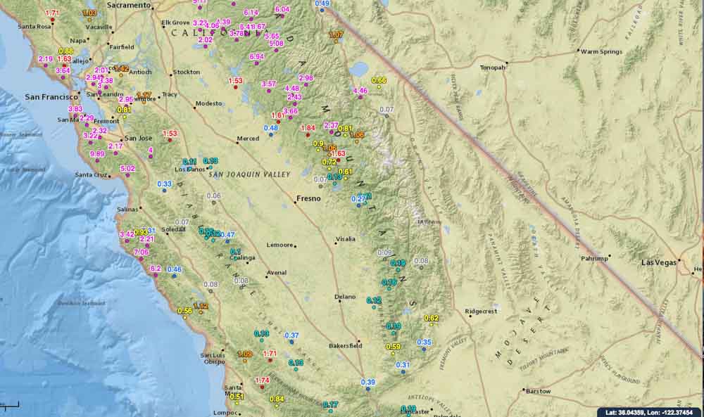
On October 19 we ran the numbers for the accumulated precipitation for the last 14 days in the western states. These maps show amounts that exceeded 0.05 inches at some of the Interagency Remote Automatic Weather Stations (RAWS).

Washington, Oregon, and northern California have received a good soaking and I would imagine that local fire officials may be declaring an end to the fire season. Of course this is not unusual for these areas this time of the year, and some locations had already seen their season end. But what IS unusual, is the high amount of moisture that occurred in just two weeks.

You can click on the images to see larger versions.

Rainfall last 2 weeks, northern California
Rainfall last 2 weeks central California
Rainfall last 2 weeks, central California

Continue to see maps for the other western states.
Continue reading “Rainfall in western states slows wildfire season in many areas”