Researchers design model that they say predicts which buildings will survive wildfire

Wildfires may seem unpredictable, leaving random ruin in their wake. But it is based on science.

Coastal Fire, Orange County, CA
Coastal Fire, Orange County, CA, May 11, 2022. ABC7.

Six months ago we wrote about a project by the First Street Foundation which claimed to have developed a system for calculating the wildfire risk of 145 million properties in the United States.

We tested the system by entering property addresses for homes at two locations that were severely impacted by recent wildfires.

  • The Marshall Fire near Boulder, Colorado last year destroyed 1,091 homes and damaged 179. We looked up the Risk Factor for three properties in a community that had total destruction. The result was that they all had a 3 of 10 “moderate fire factor”, and individually a 1.84, 2.0, 1.84 percent chance of being in a wildfire over the next 30 years.
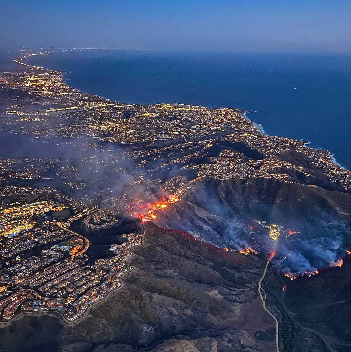
  • The Coastal Fire (see photo above) destroyed 20 homes in Laguna Niguel, California and damaged 11. The two we looked at in the zone with severe destruction received a 3 of 10 “moderate fire factor” with a 0.93 and 1.54 percent chance of being in a wildfire over the next 30 years. The homes were at the top of a steep brush-covered slope.

Another system

Colorado State University engineers have developed a model that they say can predict how wildfire will impact a community down to which buildings will burn. They say predicting damage to the built environment is essential to developing fire mitigation strategies and steps for recovery.

For years, Hussam Mahmoud, a Civil and Environmental Engineering professor, and postdoctoral fellow Akshat Chulahwat have been working on a model to measure the vulnerability of communities to wildfire. Most wildfire mitigation studies have focused on modeling fire behavior in the wildland; Mahmoud and Chulahwat’s model was the first to predict how a fire would progress through a community.

“We’re able to predict the most probable path the fire will take and how vulnerable each home is relative to the neighboring homes,” Mahmoud said. “We put a spin on the original model that allows us now to determine the level of damage in each building, whether the building will burn or survive.”

Using data from Technosylva, a wildfire science and technology company, Mahmoud and Chulahwat tested their model on the 2018 Camp Fire and 2020 Glass Fire in California. The model predicted which buildings burned and which survived with 58-64% accuracy. Since publishing their results in Scientific Reports, they have predicted which buildings burned with 86% accuracy for the Camp Fire by adjusting how the model weighs certain factors that contribute to damage.

Mahmoud says a holistic approach is needed to understand wildfire behavior and bolster resilience. Models that incorporate a community’s wildland and built environment features will give decision-makers the information needed to mitigate vulnerable areas.

Wildfire is like a disease

To develop their model, Mahmoud and Chulahwat employed graph theory, which is used to analyze networks. These methods also are used to study how diseases spread.

“Wildfire propagation in communities is similar to disease transmission in a social network,” Mahmoud said. Fire spreads from object to object in the same way contagions pass from one person to another.

Predicting survivability of structures in wildfire
Proposed relative vulnerability framework based on Degree ??? and Random walk ???? concepts implemented on (a) formulated graphs of the selected testbeds. (b) The modified degree formulation involves the following steps—(1) neighboring nodes identification, (2) Removal of low-impact connections from neighbors, and (3) Relative Vulnerability calculation. (c) The modified random walk formulation includes—(1) Generation of random walks of specific step length for each node, (2) Transmissibility calculation based on random walks generated, (3) neighboring nodes identification, (4) Removal of low transmissibility neighbors, and (5) Relative vulnerability calculation.

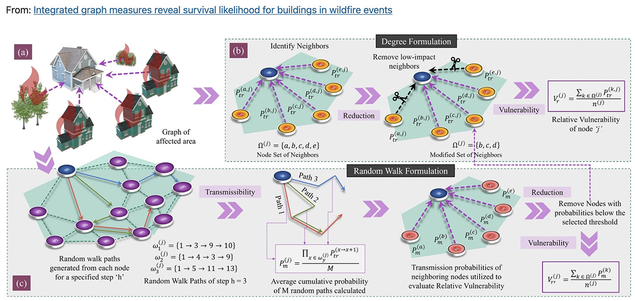
Wildfire mitigation strategies are like the tactics used to control the spread of COVID-19, he said. A community’s immune system can be boosted by mapping a structure’s surroundings (contact tracing), clearing defensible space around structures (social distancing), reinforcing structures to be more fire resistant (immunization), and creating a buffer zone at the wildland-urban interface (closing borders).

Some homes are like super-spreaders — they are more at risk of fire and more likely to transmit fire to other homes. By targeting certain homes or areas for reinforcement, policymakers could maximize a community’s mitigation efforts, Mahmoud said.

As wildfire risk is compounded by more people moving to wildland-adjacent areas and climate change drying out the landscape in arid regions, the researchers hope their model will help protect communities from the devastating losses wrought by wildfires.


“Fire science is not rocket science—it’s way more complicated.”
Robert Essenhigh, Professor Emeritus, Mechanical and Aerospace Engineering, Ohio State University.

Clayton Fire burns more than 175 structures near Lower Lake, California

The fire is burning near the scars from three very large fires from 2015

(UPDATED at 7:35 p.m. PDT August 16, 2016)

The Clayton Fire grew by 67 acres on Monday, but it was on the northeast side near the footprint of last year’s Rocky Fire.  This brings the size of the burned area up to 3,945 acres.

****

(UPDATED at 8:40 p.m. PDT August 15, 2016)

CAL FIRE is now reporting that the size of the Clayton Fire at Lower Lake, California is estimated at 4,000 acres. There has been no change in the number of structures burned.

A man has been arrested for starting the Clayton Fire and numerous others. Below is an excerpt from an article in The San Francisco Chronicle:

County officials arrested a 40-year-old Clear Lake man Monday on 17 counts of arson related to numerous fires set over the last year, including the 4,000-acre Clayton Fire that has so far claimed 175 buildings and displaced hundreds of people.

Lake County Sheriff Brian Martin and Cal Fire Chief Ken Pimlott announced the arrest of Damin Pashilk at a community meeting packed with evacuees at a casino doubling as a Red Cross shelter south of the blaze. Residents gasped at the announcement.

“All 17 counts resulted from a very extensive investigation of numerous fire starts over the last year,” Pimlott said.

****

(UPDATED at 9:03 a.m. PDT August 15, 2016)

CAL FIRE public information officer Daniel Berlant reported at 9 a.m. on Monday that the Clayton Fire has burned approximately 175 structures.

****

(UPDATED at 7:33 a.m. PDT August 15, 2016)

The Clayton Fire burned into the community of Lower Lake, California Sunday afternoon preceded by spot fires started from the burning embers the wind threw out ahead of the blaze igniting many homes and businesses.

At 6:45 a.m. on Monday CAL FIRE estimated that “100+” structures and 3,000 acres have burned.

The fire started Saturday and had died down Sunday morning, but strong erratic winds developed that pushed the fire very rapidly to the north into Lower Lake.

The fire occurred in an area that experienced three large fires in 2015, the Valley, Rocky, and Jerusalem Fires which together burned approximately 159,000 acres.

The Twitter images below are from Sunday afternoon.

****

Originally published at 8:32 p.m. PDT August 14, 2016 Updated at 10:06 p.m. PDT August 14.).

CAL FIRE reports that as of 8 p.m. on Sunday the Clayton Fire has burned 10 structures, including at least 4 residences, near Lower Lake, California, just southeast of Clearlake and 31 air miles northeast of Santa Rosa.

Based on reports from other sources, the actual number of structures destroyed is likely to rise.

After the fire started at 6 p.m. on Saturday, August 13, it burned aggressively north, crossing Morgan Valley Road and Cache Creek, impacting the communities of Lower Lake and Clearlake. St. Helena Hospital in Clearlake has been evacuated. Additional structures are threatened and mandatory evacuations are in place.

Continue reading “Clayton Fire burns more than 175 structures near Lower Lake, California”

Damage assessment update: two recent California fires have each burned almost 900 structures

California damaging fires

Updated damage assessments for two recent large wildfires in California revealed that a total of 1,770 structures burned on the two fires, including 888 on the Valley Fire south of Clearlake, and 882 on the Butte Fire south of Jackson.

For the purposes of this report, “structures” includes residences, outbuildings, and commercial properties.

Over 1,000 structures burned in two recent California wildfires

20 most damaging fires California structures burned

CAL FIRE has updated the list of the 20 most damaging fires in the state, ranked by the number of structures burned. Two recent fires made the list, but the information for those could still change since damage assessments are not yet complete.

The Valley Fire came in at number 9 with 603 structures destroyed so far, and the Butte Fire is number 14, with 408.

Map showing where structures have burned in wildfires

Structures lost to wildfires

A publication released last year by the U.S. Forest Service titled Wildfire, Wildlands, and People: Understanding and Preparing for Wildfire in the Wildland-Urban Interface has some interesting charts. The one above shows where in the United States structures have burned in wildfires.

The other chart shows that while the often-heard statement that “humans cause most wildfires” is true, that is not the case in all areas. In the Great Basin lightning is the primary cause of fires, and there are almost as many lighting fires as human caused fires in the Northwest, Southwest, and Rocky Mountains.

(Click on the charts to see larger versions.)

Lightning vs human caused wildfires

Measuring the severity of a fire season

By some measures the 2013 wildfire season in the United States was less severe than usual. In the lower 49 states this year to date there has been a decline in the number of fires, the number of acres burned, and the average size of fires. Sounds pretty good so far, right? But there was a sharp rise in the number of firefighters that were killed on fires — 34 so far this year.

Wildland Fire Fatalities 1990 through 2013

Not only did the number of fatalities more than double over last year, according to the data from the National Interagency Fire Center, but the linear trend shows an increase since 1990. The wildland fire fatality statistics from the Federal Emergency Management Agency and the U.S. Fire Administration show even higher numbers for most years.

Of course more than half of the fatalities this year occurred on one fire, the Yarnell Hill Fire which killed 19 members of the Granite Mountain Hotshots. But if that terrible tragedy had not happened, there would still have been 15 fatalities, the same number from the previous year. Between 1990 and 2013 to date the average number of wildland fire deaths is 18 each year.

We can do better. We have to do better.

More wildfire statistics:

Structures lost in wildfires, 2009 to 11-25-2013

Below are some statistics on wildland fire occurrence in the United States from 1990 through today. The numbers are for the lower 49 states, which excludes Alaska, a state that in 2013 to date has had 609 fires that blackened 1,319,234 acres, about half the number of acres that burned in the other 49 states. Fire management in Alaska is very different from the rest of the country. Some fires there are aggressively suppressed, but many fires are not staffed at all, some are fought with small numbers of firefighters, and others only get attention in areas where a remote cabin is threatened. Including Alaska numbers with the rest of the country would skew the trend analysis.

Number of wildfires, lower 49 states, 1990 - 2013

Acres burned lower 49 states, 1990 - 2013

Average size of wildfires, annually, lower 49 states, 1990-2013

Average size of fires by decade, lower 49 states, 1990 - 2013