Strong winds push Cameron Peak Fire east, prompting more evacuations

The 135,000-acre fire is west of Fort Collins, Colorado

Updated October 15, 2020   |   7:33 a.m. MDT

Map of the Cameron Peak Fire 3:06 a.m. MDT October 15, 2020
Map of the Cameron Peak Fire. The red line was the perimeter at 7:46 p.m. MDT October 13, 2020. The red dots represent heat detected by a satellite at 3:06 a.m. MDT October 15, 2020.

By mid-afternoon on Wednesday the very strong winds gusting to 50 mph that pushed the Cameron Peak Fire about 17 miles to the east toward Fort Collins slowed. A satellite showed very little spread east of Buckhorn Road which is about 6 miles west of Horsetooth Reservoir. Most of the additional acres Wednesday night were on the south side of the 17-mile run, northeast of Rocky Mountain National Park.

At 6:16 a.m. Thursday the Incident Management Team reported the fire had grown to 164,140 acres.

To see all articles on Wildfire Today about the Cameron Peak Fire including the most recent, click here.

Overnight a weather station at the CSU Mountain Campus recorded 5 mph winds out of the west gusting at 10 to 14 mph while the relative humidity remained low, in the low 20s, with a low temperature of 30 degrees.

A mapping flight scheduled for Wednesday night had to be cancelled due to clouds over the fire.

The weather forecast for Fort Collins calls for a shift in the wind, to come out of the east. This could reduce the smoke in the city and the threat to property between Buckhorn Road and Horsetooth Reservoir.


Updated October 14, 2020   |    10:36 p.m. MDT

Map Cameron Peak Fire, Oct. 14, 2020
Map of Cameron Peak Fire, afternoon of Oct. 14, 2020. Incident Management Team.

The Incident Management Team updated their map of the Cameron Peak Fire which was pushed by strong winds about 17 miles to the east Tuesday night and Wednesday. By mid-afternoon Wednesday it had reached Buckhorn Road about 6 miles west of Horsetooth Reservoir.

During the extreme growth of the fire structures burned, but until the intensity of the blaze decreases it could be days before the details will be available.

Now at 158,300 acres, it has become the largest fire in the recorded history of Colorado, surpassing the Pine Gulch Fire which blackened 139,007 acres north of Grand Junction a month ago.

The huge pyrocumulus cloud that formed over the fire was creating rain 100 miles downstream from the smoke plume at 9 p.m. MDT Wednesday.

Cameron Fire pyrocumulus radar


Updated: October 14, 2020   |    4:18 p.m. MDT
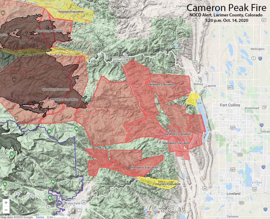
Map showing Cameron Peak evacuations 3:20 p.m. MDT, October 14, 2020
Map showing Cameron Peak evacuations at 3:20 p.m. MDT, October 14, 2020. Map by NOCO Alert, Larimer County.

The map above shows the mandatory evacuations have extended east to Horsetooth Reservoir.

A satellite pass at 1:12 p.m. MDT Wednesday, below, shows the spread of the Cameron Peak Fire to the east. At that time is was 8 miles west of Horsetooth Reservoir.
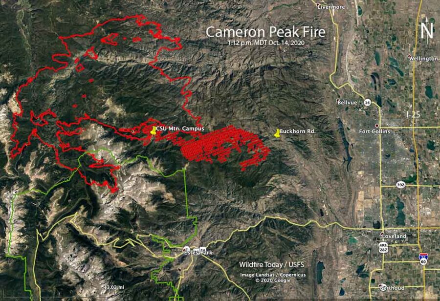
Map of the Cameron Peak Fire
Map of the Cameron Peak Fire. The red line was the perimeter at 7:46 p.m. MDT October 13, 2020. The red dots represent heat detected by a satellite at 1:12 p.m. MDT October 14, 2020.

October 14, 2020   |    3:15 p.m. MDT

Cameron Peak Fire evacuations
Cameron Peak evacuations October 14, 2020. Map by NOCO Alert, Larimer County.

Very strong winds that began after sunset Tuesday caused the Cameron Peak Fire to become much more active. Mandatory and voluntary evacuations are in effect west of Fort Collins, Colorado (see the map above). This is a rapidly evolving situation.

To see all articles on Wildfire Today about the Cameron Peak Fire, including the most recent, click here.

Wednesday afternoon at about 2 p.m. the Larimer County Sheriff ordered the immediate mandatory evacuation of Redstone Canyon, advising, “Do not delay leaving to gather belongings or make efforts to protect your home or business. For updates, text the word LCEVAC to 888777 from your cell phone. We will communicate information to that key word as needed.”

The Larimer County webpage also has information about the Cameron Peak Fire. Evacuation information can be found at nocoalert.org.
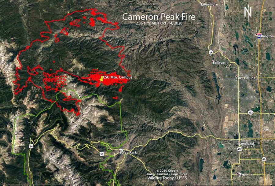
Cameron Peak Fire map
Map of the Cameron Peak Fire. The red line was the perimeter at 7:46 p.m. MDT October 13, 2020. The red dots and the solid red area represent heat detected by a satellite at 2:36 a.m. MDT October 14, 2020.

The Incident Management Team reported at 1 p.m. Wednesday that the fire was on top of Signal Mountain, and had spread approximately 10 miles east of the Colorado State University Mountain Campus (CSU). It was spreading to the east and east-southeast, in the general direction of Fort Collins. The smoke plume from the fire is massive and is being detected by radar and satellites.
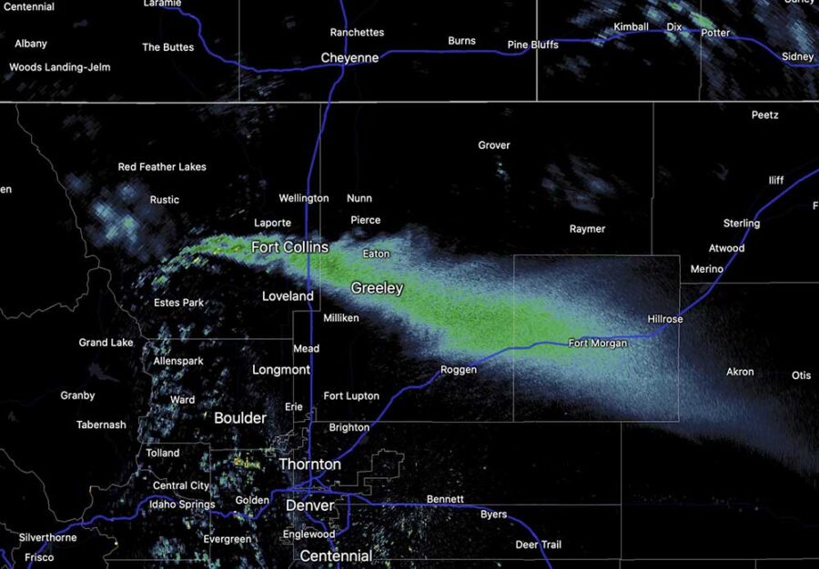
Cameron Peak Fire radar smoke
Smoke from the Cameron Peak Fire shows up on radar at 1:55 p.m. MDT October 14, 2020.

Tuesday afternoon the weather station at the CSU Mountain Campus recorded 8 to 16 mph winds out of the west gusting at 20 to 38 mph. After sunset the speed increased throughout the night and into Wednesday afternoon blowing out of the west-southwest at 20 to 35 mph gusting at 33 to 50 mph, with a peak gust of 60 at 11:32 a.m. Wednesday. The relative humidity was in the low 20s all night and rose to the high 20s Wednesday afternoon with the temperature in the 30s.
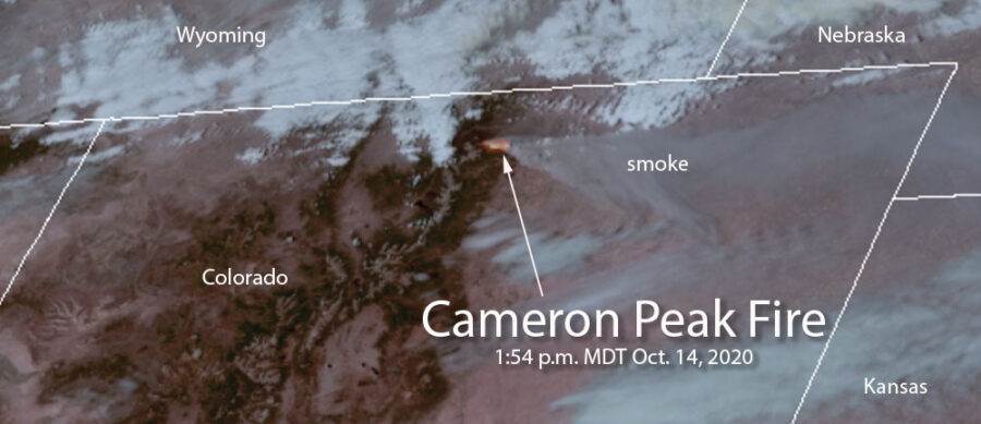
Cameron Peak Fire satellite image
Satellite image showing heat and smoke from the Cameron Peak Fire at 1:54 p.m. MDT October 14, 2020.

Wetter conditions in Australia may lead to a fire season very different from a year ago

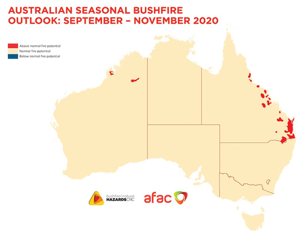
Australia fire outlook September through November, 2020

The 2020/21 fire season will be influenced by vastly different climate drivers than the previous two fire seasons, according to a September through November outlook from the Bushfire and Natural Hazard Cooperative Research Centre.

With a La Niña ALERT now active, large areas of eastern and northern Australia are expecting wetter than average conditions through spring. Despite the wetter climate signals, parts of Queensland face above normal fire potential in the south east and central coast, extending to the north.

While these wetter conditions in eastern Australia will help in the short-term, they may lead to an increase in the risk of fast running fires in grasslands and cropping areas over summer.

In contrast to the wetter conditions for the east, dry conditions persist in Western Australia, with above normal fire potential continuing to be expected in parts of the north.

Australia temperature outlook, October through December, 2020


Australia precipitation outlook October through December, 2020


Australia plans on having six large air tankers available during the 2020-2021 bushfire season.

California to face elevated wildfire danger again this week

Fire Weather Watch for Northern California and heat advisory for the southern part of the state

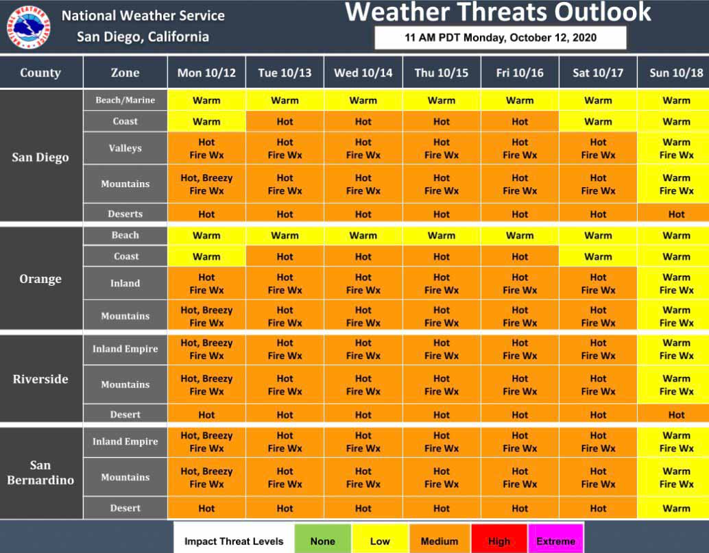
Southern California fire weather this week
Southern California fire weather this week. NWS.

Firefighters in California could face another round of wildfires this week as the weather turns hot, dry, and windy in some locations.

In Southern California a heat advisory has been issued for Tuesday through Friday for highs in the lower elevations approaching 100 degrees.

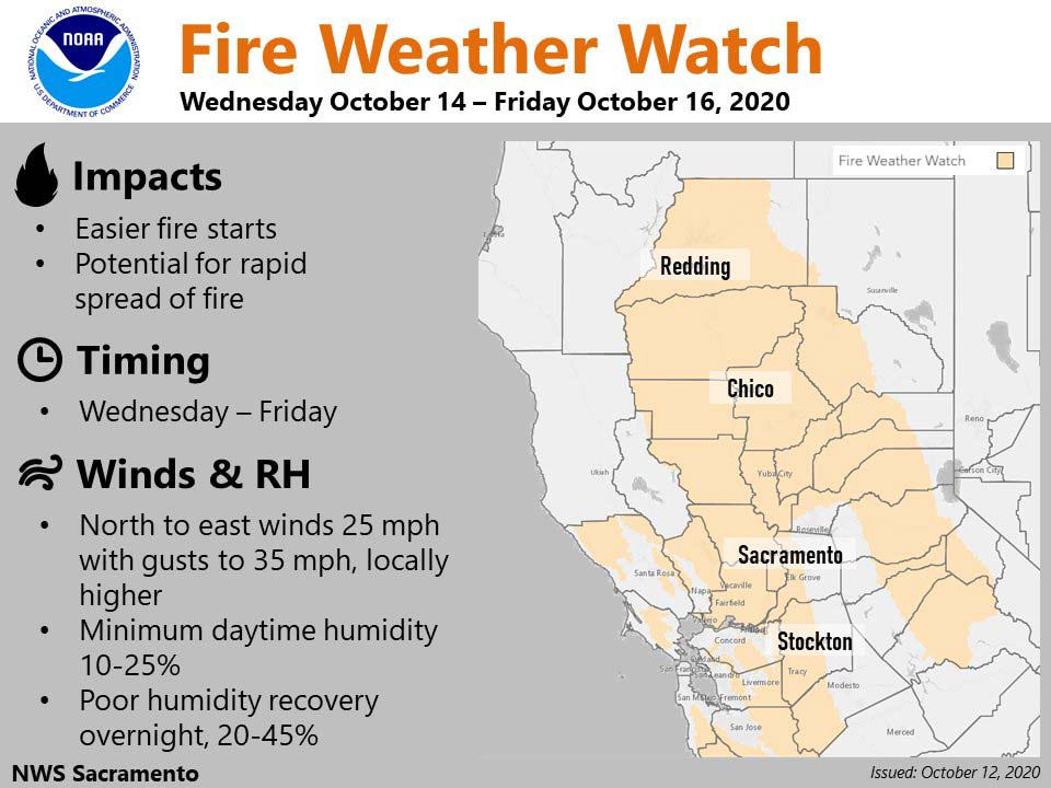
A Fire Weather Watch for Northern California is in effect Wednesday through Friday for breezy conditions, with the strongest winds expected Wednesday and Thursday.

There is a possibility of electrical power being preemptively being shut off by PG&E due to windy and dry conditions.

Possibility of electrical power being preemptively being shut off
Possibility of electrical power being preemptively being shut off this week by PG&E due to windy conditions.
Northern California fire weather this week
Northern California Fire Weather Watch this week.
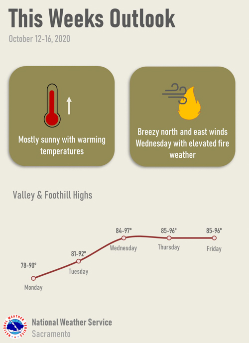
Sacramento area fire weather this week
Sacramento area fire weather this week. NWS.

Award granted to develop system to detect and forecast the spread of all wildland fires in U.S.

Pyregence fire forecasting tool
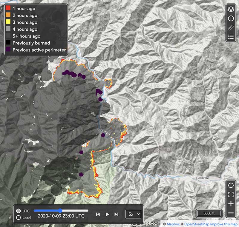
Pyregence fire forecasting tool, beta version. Forecast for the northeast side of the Red Salmon Complex of fires in Northern California at 4 p.m. PDT October 9, 2020.

The U.S. Department of Commerce’s National Institute of Standards and Technology (NIST) has awarded 19 small businesses in 12 states a total of more than $4.4 million in grants to support innovative technology development. One of those grants, for $100,000, is to help build a system for automatically detecting and forecasting the spread of every wildfire in the continental United States and updating the forecasts as conditions change.

Reax Engineering Inc. of Berkeley, California, the company that received the grant, has a beta version of the forecasting tool online now just for the state of California. It is a work in progress and will eventually include data for fires in other  states.

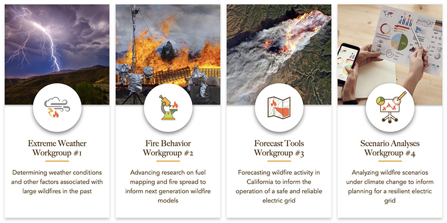
Wildfire forecasting is one of the four primary goals of Pyregence, a group of fire-science labs and researchers collaborating about wildland fire, where the forecasting tool now resides. The organization brings together initiatives and leading researchers from 18 institutions representing industry, academia, and government in an effort to transform how wildfire mitigation and adaptation measures are implemented. In addition to forecasting wildfire activity, wildfire scenario analyses will be produced to inform future wildfire risk and California’s 5th Climate Change Assessment, using open science and technology principles.

Pyregence working groups
Pyregence working groups.

In order to predict the spread of wildfires, fire behavior models are run on computers. The versions that have been used for decades are not accurate for dealing with heavy dead and down fuels or fires spreading through the crowns of trees under extreme weather conditions. The goal of one of the four Pyregence workgroups, the Fire Behavior Workgroup, is to improve existing models or develop new ones. That effort is being led by Scott Stephens, Professor of Fire Science, and director of the University of California Center for Fire Research and Outreach.

Missoula Fire Lab burn chamber
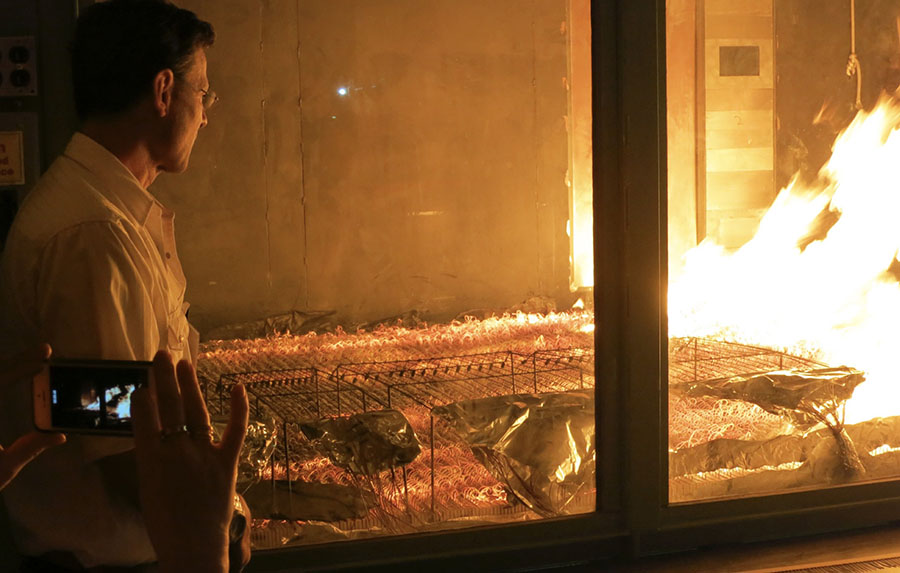
U.S. Forest Service Missoula Fire Lab burn chamber, May 21, 2014. Photo by Bill Gabbert.

Mark Finney, a researcher at the U.S. Forest Service Missoula Fire Sciences Laboratory, is part of the Fire Behavior Workgroup and will soon have access to a burn chamber much larger than the one in the photo above. It will reportedly be the size of a grain silo. These wind tunnel/combustion chambers are used to conduct burning experiments in a controlled environment under varying fuel, temperature, humidity, and wind conditions. It can lead to a better understanding of how vegetation burns, leading to improvements in predicting fire spread.

An article at Wired describes the planned burn chamber:

Once complete, that chamber will let him replicate wildfire fuel beds by piling logs and other material as much as a few feet deep. He will then ignite them, hit them with wind and moisture, and quantify their burn rate and energy-­release rate—what he calls the “heat-engine part of mass fires.”

“Really what we’re looking for,” Finney says, “is how these things transition to flaming. Instead of just smoldering on the forest floor, how do they become actively involved in these large fires?”

If all goes well, Finney’s working group will eventually code three-dimensional digital simulations of various wildland fuel beds—digital cubes, in essence, not unlike Minecraft voxels—that can be stacked and arranged in infinite variation across landscapes generated by GIS mapping data.

Rain and snow slow Mullen and Cameron Peak Fires in Colorado and Wyoming

Very strong, dry winds, and sun are in the forecast

October 11, 2020   |   10:44 p.m. MDT

Big Laramie Volunteer Fire Department Station 4
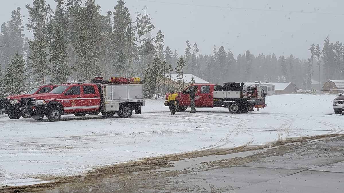
Photo by Big Laramie Volunteer Fire Department Station 4, in Wyoming near the Mullen Fire.

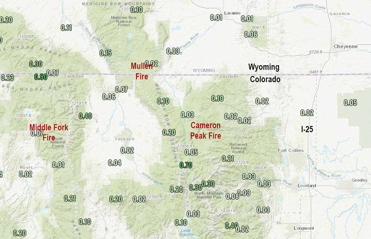
Rain and snow hit portions of three fires in north-central Colorado Sunday slowing the spread of the Cameron Peak, Middle Fork, and Mullen Fires.

The Mullen Fire which extends across the state line into Wyoming had received one-half to two inches of snow by mid-afternoon Sunday in the higher elevations. The fire has burned 175,535 acres in the two states.

To see all articles on Wildfire Today about the Cameron Peak Fire, including the most recent, click here.

The 134,559-acre Cameron Peak Fire, which burned up to the Colorado State University Mountain Campus, received about one inch of snow in the higher elevations.

A weather station near the 17,832-acre Middle Fork Fire north of Steamboat Springs recorded 0.07″ of precipitation Sunday.

Precipitation October 9 through 11, 2020
Precipitation October 11, 2020 through 10 p.m. MDT.

Strong winds are in the forecast for the area through Wednesday. The temperature in the higher elevations of the Mullen Fire will reach about 20 degrees or lower Sunday night. The forecast for Cowdrey, Colorado near the Mullen Fire calls for mostly sunny skies Monday through Wednesday, high temperatures around 60, relative humidity of 20 percent, and afternoon winds gusting at 30 to 50 mph out of the west and southwest.

A small amount of rain or snow is unlikely to completely put out these fires which are mostly burning in timber. It will be interesting to see how much the fuels dry out in the next three days with very strong winds, sun, and low humidities.


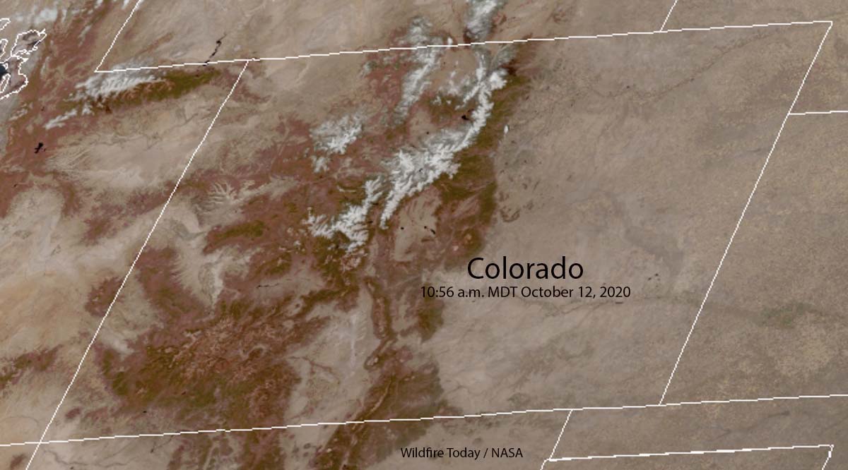
UPDATE at 12:10 p.m. MDT October 12, 2020. The satellite photo below shows snow in the mountains of north-central Colorado at 10:56 a.m. MDT October 12, 2020.

Colorado snow mountains fires
Satellite photo showing snow in the mountains of north-central Colorado at 10:56 a.m. MDT October 12, 2020.
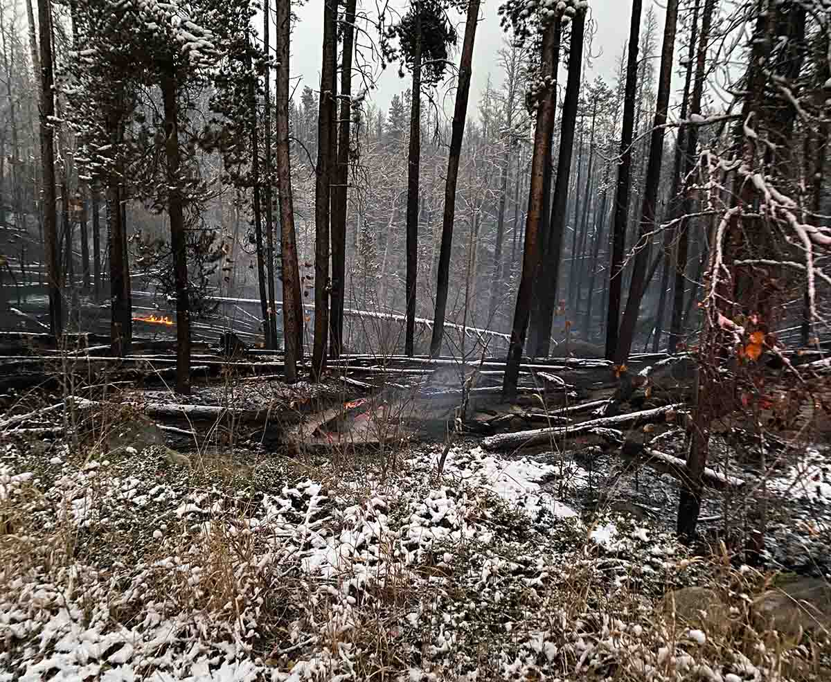
Cameron Peak Fire snow
Cameron Peak Fire still burns with snow on the ground, October 11, 2020. Incident Management Team photo.
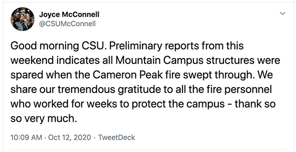
CSU campus status fire
President of Colorado State University

Zogg Fire investigators seize PG&E equipment

Four people died in the fire southwest of Redding, California

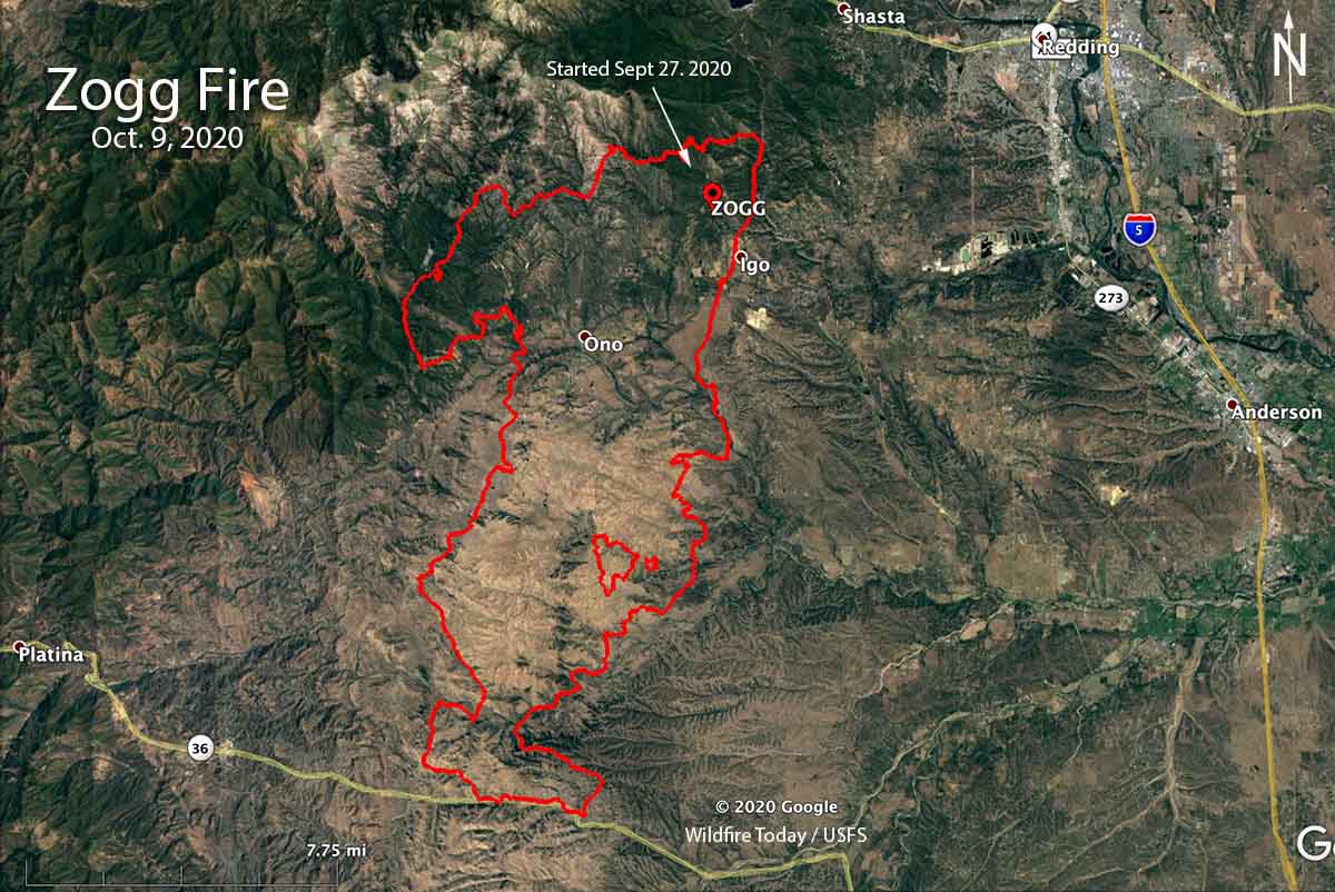
Map of the Zogg Fire
Map of the Zogg Fire October 9, 2020.

Investigators from the California Department of Forestry and Fire Protection looking for the cause of the Zogg Fire seized Pacific Gas and Electric equipment, the utility said Friday in a notification to the state Public Utilities Commission.

The Zogg Fire started about 9 miles southwest of Redding, California during hot, dry, and windy conditions on September 27, 2020 and ran south for 16 miles until firefighters were able to stop it at Highway 36 about 9 miles east of Platina.

Four people were killed in the fire and 103 residences and 101 other structures were destroyed. The estimated costs of suppressing the fire through October 9 are $29 million.

In PG&E’s filing to the PUC, the company said their equipment reported alarms and other activity in the area of Zogg Mine Road and Jenny bird Lane between approximately 2:40 p.m. and 3:06 p.m. on September 27, when the line recloser de-energized that portion of the circuit. The filing says wildfire detection cameras and satellite data showed heat or signs of smoke at that location between approximately 2:43 p.m. and 2:46 p.m.

BakersfieldNow has information about the four fatalities.

The Shasta County Sheriff’s Office identified one of the victims as Alaina Michelle Rowe, 45, who was found dead along a road on Sept. 28. The sheriff’s department said another victim was a minor but did not report the identity. KRCR-TV in Redding reported that Rowe and her eight-year-old daughter Feyla died as they tried to escape the fire.

The two other victims, also found a day after the fire started, are Karin King, 79, who was found on the road where the fire started, and Kenneth Vossen, 52, who suffered serious burns that day and later died in a hospital.

Neither PG&E or CAL FIRE have disclosed exactly what equipment the investigators seized.

CAL FIRE has not released their findings about the cause of the Zogg Fire.

After their equipment was blamed for starting the Camp Fire, in June of this year PG&E pleaded guilty to involuntary manslaughter for the 84 people that were killed when the fire burned through Paradise, California November 8, 2018. The fire also burned 154,000 acres and destroyed more than 18,000 structures. As part of the investigation for that fire, CAL FIRE personnel seized electrical equipment on or near a 100-year old PG&E transmission tower near the point of origin.

Previously the power company has reached settlements with victims from wildfires in 2015, 2017 and 2018, totaling about $25.5 billion, NBC news reported.