Cove Fire on Modoc NF doubles in size

It grew by approximately 10,000 acres on Tuesday.

Above: The Cove Fire in northeast California. Uncredited and undated; posted to Inciweb August 2, 2017.

(Originally published at 12:25 p.m. PDT August 2, 2017)

One of the fires in the Modoc July Complex of fires on the Modoc National Forest in northeast California was extremely active Tuesday and Tuesday night. The Cove Fire, now three miles northwest of Adin, population 272, spread two to four miles to the southwest and one mile southeast, doubling in size. It added another 10,000 acres to bring the size to about 22,000 acres. All of the fires in the Complex combined have burned a total of 73,465 acres.

The Cove Fire became plume dominated Tuesday and by evening had generated cloud-to-cloud lightning and increased winds as a result of the intense heat buildup and atmospheric conditions. Extreme fire behavior in the form of fire whirls and spotting caused the fire to further advance southwest towards a prepared dozer line near County Roads 90 and 87. Resources were immediately deployed to connect the dozer line around the fire’s southwestern edge and protect structures. They utilized tactical firing to reinforce and create a buffer inside the dozer line.

The additional growth moved into lighter fuels which should offer less resistance to control.
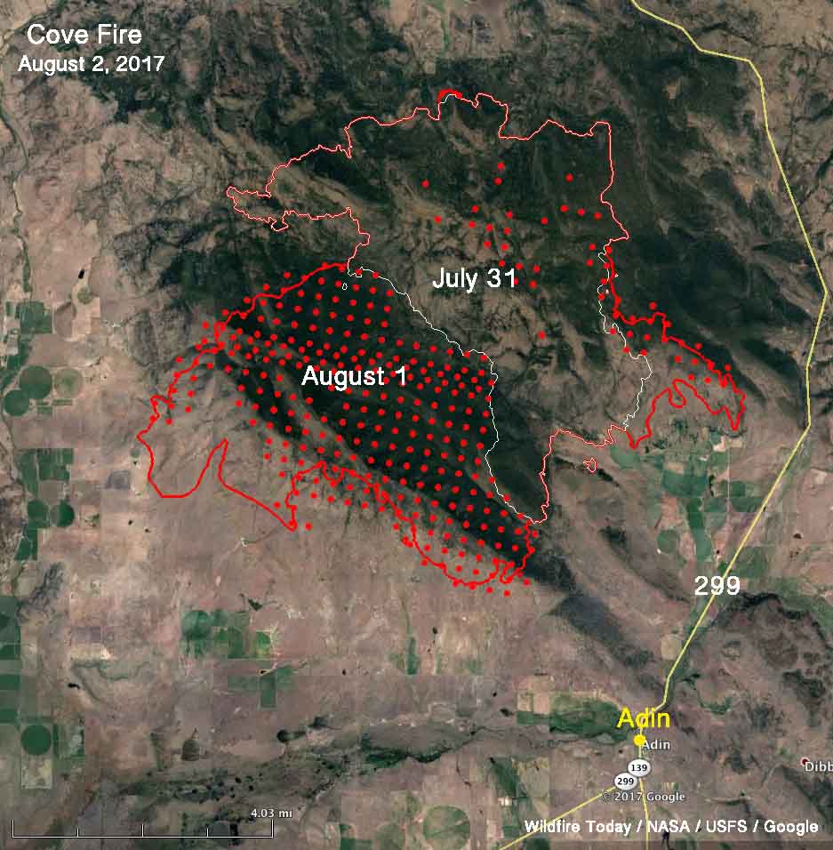
Cove Fire map
Map of the Cove Fire. The red line was the perimeter at 1:30 a.m. PDT August 2, 2017. The white line was the perimeter about 27 hours before. The red dots represent heat detected by a satellite at 2:48 a.m. PDT August 2.

Another fire in the Complex, the Steele Fire east of Clear Lake, was active but remained within the constructed fireline around the northeast corner of the fire. Crews put in handline along the east side to tie two dozer lines together and Wednesday will be working on fireline along the entire eastern edge.

All of the articles about the Modoc July Complex of fires can be found here, with the most recent at the top. 

Fires in Western Montana still very active

The fires are consuming thousands of acres each day and producing large quantities of smoke.

Above: Satellite photo taken August 1, 2017 showing smoke produced by wildfires in western Montana and Northeastern Idaho. The red dots represent heat detected by a sensor on the satellite.

(Originally published at 10:48 a.m. MDT August 2, 2017)

The residents of Western Montana have been dealing with wildfire smoke for several weeks and there is no relief in sight.

Our map above identifies eight of the largest blazes in the area. Here are a few facts about some of them, with them ranked in priority order according to fire management officials.

  • Rice Ridge: Six miles north of Seeley Lake, MT; 3,994 acres, 150 personnel assigned.
  • Sunrise: Six miles south of Riverbend, 9,900 acres, 548 personnel assigned.
  • Sapphire Complex: Three fires, 15 miles southeast of Clinton, MT, 12,756 acres, 864 personnel assigned.
  • Lolo Peak: 8 miles southwest of Lolo, MT, 5,724 acres, 822 personnel assigned.
  • Arrastra Creek: 6 miles northwest of Lincoln, MT, 3,675 acres, 127 personnel assigned.
  • Whetston Ridge: 25 miles southwest of Philipsburg, MT, 3,621 acres, 30 personnel assigned.

Animating still photos of fires

Today I have been experimenting with an app that recently became available for iPhones and iPads, called Plotagraph. It can be used to animate still photos and seems like a natural for manipulating photographs of fires. You can’t use the app to create new stuff in the photo, but you can take what’s there and make it move.

So far I’ve worked on three photos. One had flames that were fairly easy to isolate and another had smoke that was easy to work with. The third was a B-17 dropping retardant.

The way it works is, first you identify what areas in the photo you do not want to animate, then you indicate the direction and speed for the motion. When finished, it can be saved as a video.

The first one, below, shows a member of the Alpine Hotshots who was working on the 2014 Norbeck Prescribed Fire in Custer State Park.

The next one is from the 2012 White Draw Fire.

And finally, retardant from a B-17.

If you’re having trouble viewing the videos, you can see them on YouTube.

To get your own prints of the original still images…..

Art Prints

Photography Prints

Sell Art Online

Wildfire potential — August through November

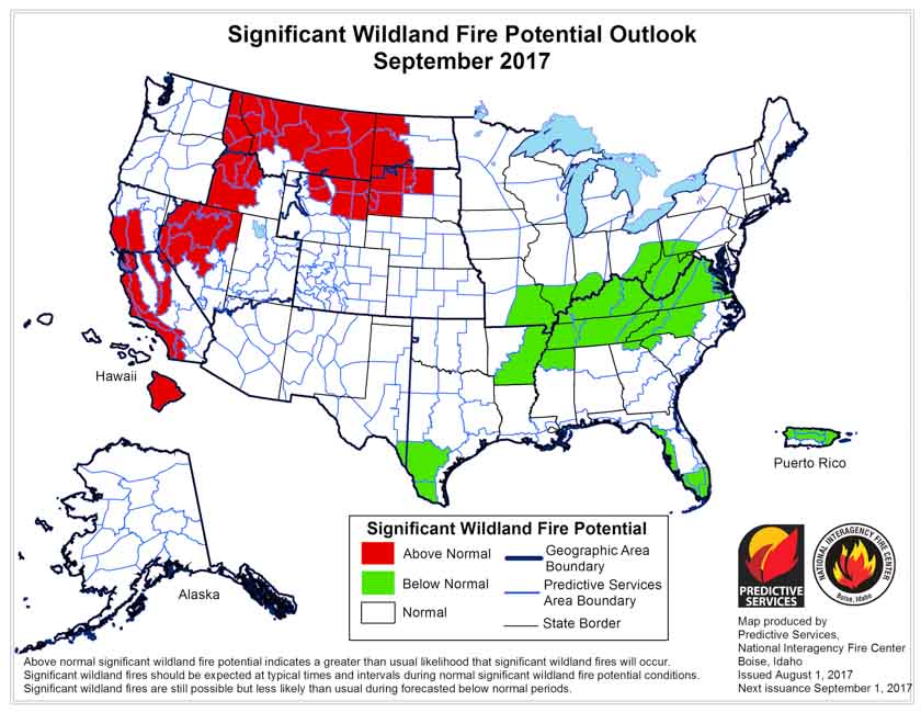
The prediction for August shows enhanced fire potential for the Northern Rockies, Northern Nevada, and much of California and the Northwest.

On August 1 the Predictive Services section at the National Interagency Fire Center issued their Wildland Fire Potential Outlook for August through November. The data represents the cumulative forecasts of the ten Geographic Area Predictive Services Units and the National Predictive Services Unit.

It revises the outlook that was issued for August a month ago, adding to the “Above Normal” category Northern Idaho, the eastern halves of Oregon and Washington, and Western Montana. Many of the August “Above Normal” areas will carry over into September except for the areas in Oregon and Washington.

Below are:

  • the highlights of the NIFC report;
  • NIFC’s graphical outlooks for September through November;
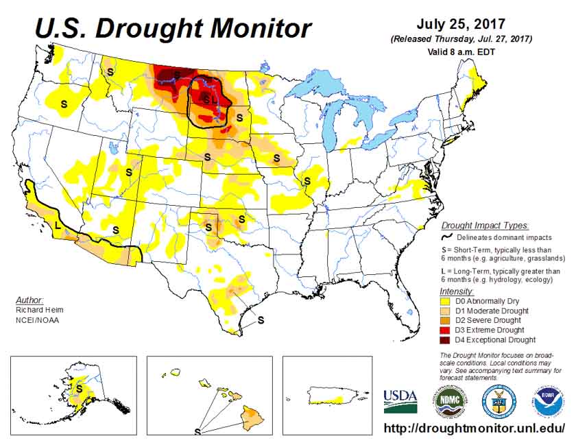
  • Drought Monitor, and;
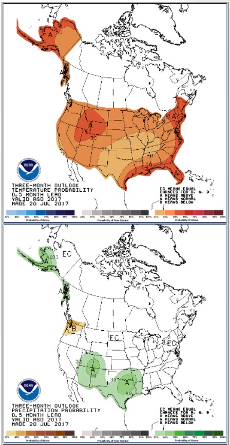
  • NOAA’s long range temperature and precipitation forecasts.

****

The seasonal transition of the western fire season north has occurred. A strong southwestern monsoon has developed over the Southwest and has reduced the significant large fire potential and activity across the Four Corners Region. Significant lightning activity associated with the monsoon has spread north creating numerous incidents across the northern Great Basin, Northern California, Pacific Northwest, and the Northern Rockies. With the fine fuels now fully cured and with larger fuels now receptive, even at the higher elevations, fire activity is increasing as it nears its seasonal peak in August. While the northwestern states have shown a significant upturn in activity, fire activity in Alaska has begun to wane with the arrival of the late summer rains across the Alaskan Interior. The eastern and southeastern states have seen and will continue to experience overall limited activity as the regions remain largely out of season.

Precipitation received was generally well below average across the western half of the country in July. With the occurrence of three significant heat wave events, fuels dried quickly and became receptive to fire earlier than in most years. By month’s end, the previous winter’s record snowpack and above average spring rainfall was a distant memory. Drought was beginning to reemerge in the Rockies and across portions of the Pacific Northwest. Across the northern Great Plains, the established long term drought conditions continued to worsen. Large fire activity became problematic across eastern Montana, Wyoming and the Dakotas.

Looking forward to the peak of the western fire season in August and September, conditions are expected to remain favorable for the Above Normal significant fire activity to continue. Areas with the greatest potential for significant large fire activity will be the grasses and rangelands of the Pacific Northwest east of the Cascades, the lower and middle elevations across California, most of the Northern Rockies region. The grass and rangelands across the northern Great Basin will also continue to demonstrate Above Normal significant large fire potential and activity.

****

September wildfire potential

October November wildfire potential

****

drought monitor

****

90 day outlook weather

Elephant Hill Fire in British Columbia grows to 194,000 acres

The fire has been burning near Cache Creek, BC since July 6, 2017.

Above: Satellite photo showing the location wildfires in British Columbia and Alberta, July 31, 2017. The red dots represent heat detected by the satellite.

(Originally published at 7:32 p.m. MDT July 31, 2017)

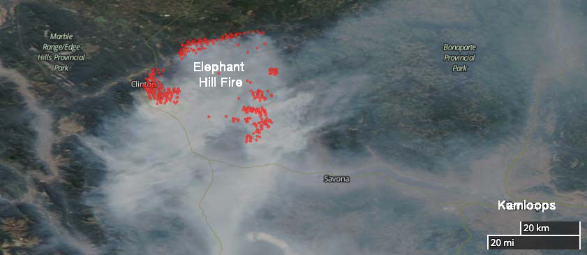
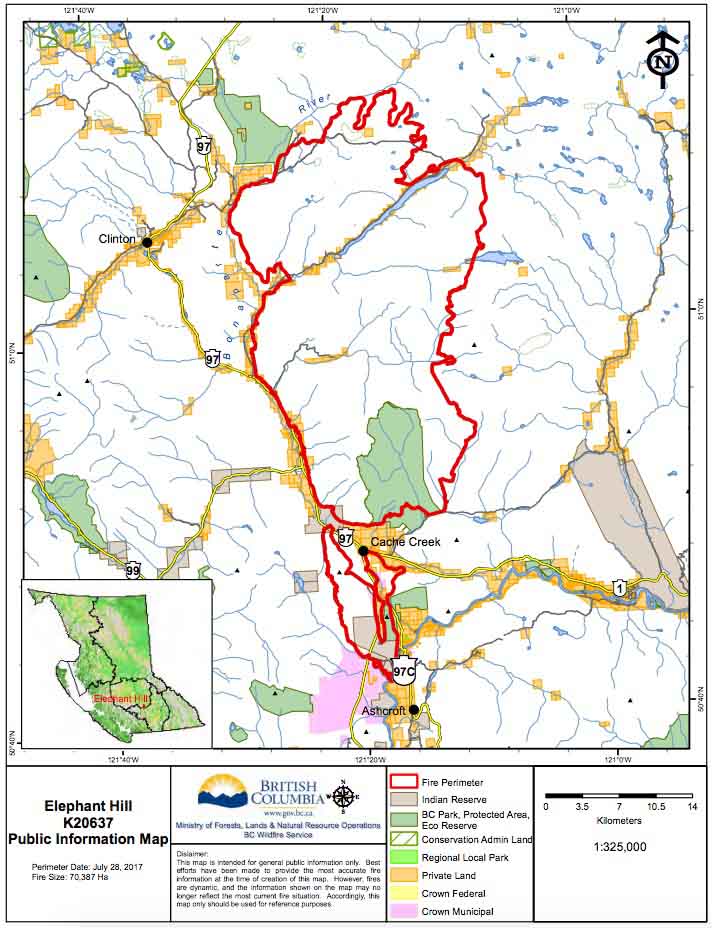
Currently there are many wildfires burning in British Columbia and Alberta. One of them is a megafire just east of Clinton, north and south of Cache Creek, and about 50 miles northwest of Kamloops. I’m not sure if it’s the Mother of All Fires, for this year anyway, but so far it has covered 78,548 hectares (194,096 acres). The BC Wildfire Service says that number is probably low, since the visibility has prevented them from conducting mapping flights for a day or two.

(More recent information about the Elephant Hill Fire and other fires in British Columbia was posted August 2, 2017.)

The recent warmer and drier weather has contributed to increased growth in recent days. On Sunday most of the spread was on the north and west sides.  The objective on the west flank is to remove excess fuel ahead of the fire, keep it south of the Bonaparte River, and slow the aggressive fire behavior. Night shift crews are working from 8 p.m. to 8 a.m. to reinforce firelines.

Structure protection personnel, engines, and equipment are assigned 24 hours a day. They are working across the fire to conduct property assessments, establish sprinkler systems on structures, and protect values where needed.

Elephant Hill Fire map
Satellite photo showing smoke on the Elephant Hill Fire northwest of Kamloops, July 31, 2017. The red dots represent heat detected by the satellite.

The community of Clinton and areas to the northeast including Green Lake have been evacuated.

Resources assigned to the fire include 20 helicopters and 69 pieces of heavy equipment for a total of 359 firefighters.

The map below was current July 28, 2017.

Elephant fire map