New California law requires seller of home to disclose vulnerability to wildfires

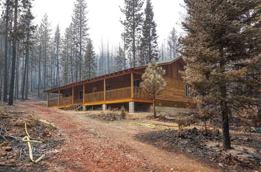
EIler Fire Home
One of the homes that survived the Eiler Fire in northern California, August, 2014. Photo by Bill Gabbert.

Beginning January 1 in California the seller of a home in a designated high fire area built before 2010 must disclose to the buyer conditions that make the home vulnerable to wildfires.

The seller must provide documentation stating that the property is in compliance with local laws pertaining to defensible spaces or local vegetation management laws. If there is no such local law, the seller shall provide documentation of compliance with state law, assuming the seller obtained such documentation within six months prior to entering into the transaction. But if neither of the above, the seller and the buyer must enter into a written agreement in which the buyer agrees to obtain documentation of compliance with defensible space or a local vegetation management ordinance after close.

Here are the details from the legislation:


Disclosures re Home Hardening

Beginning January 1, 2020, if a seller, after completion of construction, has obtained a final inspection report regarding compliance with, among other things, home hardening laws (Gov’t Code 51182 and 51189*), the seller shall provide to the buyer a copy of that report or information on where a copy of the report may be obtained.

Beginning January 1, 2021, this law requires for properties located in high or very high fire hazard severity zones for homes built before 2010, delivery of a notice to include the following three items:

1. A statutory disclosure that includes information on how to fire harden homes as follows:

“This home is located in a high or very high fire hazard severity zone and this home was built before the implementation of the Wildfire Urban Interface building codes which help to fire harden a home. To better protect your home from wildfire, you might need to consider improvements. Information on fire hardening, including current building standards and information on minimum annual vegetation management standards to protect homes from wildfires, can be obtained on the internet website http://www.readyforwildfire.org.”

2. Disclosure of a list of features that may make the home vulnerable to wildfire and flying embers if the seller is aware. The list includes, among other things, untreated wood shingles, combustible landscaping within five feet of the home, and single pane glass windows.

3. On or after July 1, 2025, a list of low-cost retrofits re home hardening (listed pursuant to Section 51189 of the Government Code*). The notice shall disclose which listed retrofits, if any, that have been completed during the time that the seller has owned the property.

Potential point of sale compliance requirements re defensible space or local vegetation management laws

Beginning July 1, 2021 seller of property in high or very high fire hazard zones shall provide documentation to the buyer stating that the property is in compliance with laws pertaining to state law defensible spaces (Public Resources Code 4291**) or local vegetation management ordinances, or in certain cases the buyer and seller will agree that the buyer is to obtain the documentation after close as follows

1. If there is a local ordinance requiring the seller to comply with state law governing defensible spaces (PRC 4291**) or a local vegetation management ordinance, the seller shall provide the buyer with: 1) a copy of the documentation of such compliance, and 2) information on the local agency from which a copy of that documentation may be obtained.

2. But If no such local ordinance exists, and the seller has obtained an inspection from a state, local or other government agency or qualified nonprofit which provides an inspection with documentation for the property, the seller shall provide the buyer with: 1) the documentation of the inspection if obtained within six months prior to entering into a transaction to sell the real property and 2) information on the local agency from which a copy of that documentation may be obtained.

3. If seller hasn’t obtained documentation of compliance per 1 or 2 above, then the seller and buyer shall enter into a written agreement stating that the buyer agrees to: a) obtain documentation of compliance per the local ordinance or b) if there is no such local ordinance, the buyer shall, within one year, obtain documentation of compliance as long as there is a state, local or other government agency or qualified nonprofit which provides an inspection with documentation of compliance for the property.

This law also requires the California Office of Emergency Services (Cal OES) to enter into a joint powers agreement with the Department of Forestry and Fire Protection (Cal FIRE) to administer a comprehensive wildfire mitigation and assistance program to encourage cost-effective structure hardening and facilitate vegetation management, contingent upon appropriation by the Legislature.

Red Gully Bushfire north of Perth forces evacuations in Western Australia

It is spreading toward Lancelin on the coast

map bushfire western australia
The icons on the map represent heat detected at the Red Gully Bushfire by a satellite at 2:10 a.m. AWT January 6, 2021.

A large bushfire has forced some residents in Western Australia to leave their homes. The Red Gully Bushfire has been burning since January 2 between the Gingin and Dandaragan areas about 100 km. north of Perth. The blaze stretches from Regans Ford west toward Lancelin and is burning toward Indian Ocean Drive.

Emergency WA issued the following warning at 7:44 a.m. AWT January 6, 2021:

Bushfire Emergency Warning – in or near OCEAN FARMS ESTATE, SEAVIEW PARK and surrounding areas bounded by Brand Highway to the east, Nammegarra Road to the north, the northern end of Mimegarra Road, Meadows Road, the coast to the west, Sappers Road to the south, Indian Ocean Drive, K.W. Road, Sappers Road, Cowalla Road and east to Brand Highway at the Orange Springs Road intersection across the northern edge of Moore River National Park in parts of REGANS FORD, COWALLA, MOORE RIVER NATIONAL PARK, NILGEN, MIMEGARRA, WEDGE ISLAND, KARAKIN, ORANGE SPRINGS and LANCELIN in the SHIRES OF GINGIN and DANDARAGAN

The fire has burned more than 2,000 ha (4,900 acres) and has been spreading to the west or west-northwest at about three kilometers per hour.

Two of Coulson’s C-130 air tankers that are on contract in Australia are now positioned in Western Australia.

Coulson C-130 air tankers
Coulson C-130 air tankers, 131 and 132. (They have different numbers in Australia) Coulson photo.

Red Gully Fire

Thanks and a tip of the hat go out to Bean.

BLM intends to give grazing permits to members of the Hammond family that served time for arson on public lands

Would grant access to 26,000 acres for $1.35/month per animal

Dwight and Steven Hammond
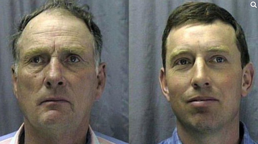
Booking photos of Dwight and Steven Hammond (Photos: U.S. Department of Justice)

The Bureau of Land Management is proposing to issue four grazing permits to the Oregon-based Hammond Ranch which for 10 years would allow them access to 26,000 acres of taxpayers’ land for $1.35 per animal unit month.

On September 30, 2001 the two Hammonds distributed boxes of matches to everyone in their hunting party with instructions to“light up the whole country on fire”. Initially they ignited fires on their property but the fires spread onto 139 acres of federal land.

Steven Hammond was also convicted of setting a series of fires on August 22, 2006. Those ignitions, during Red Flag Warning conditions, compromised the safety of firefighters who were working on another fire nearby. Some of them were forced to retreat from the area for their own safety. They were given advice and led to safety via radio by an orbiting Air Attack.

The Hammond case inspired the 40-day armed occupation of the Malheur National Wildlife Refuge in 2016. Robert LaVoy Finicum, one of the occupiers died, but brothers Ammon and Ryan Bundy, the accused leaders of the occupation, were not convicted.

While the Hammonds were in prison for the arson convictions, President Trump issued them full pardons. For more information about the Hammonds, check out the detailed timeline we put together covering their interactions with the legal system between 1994 and 2015.

Anyone can protest the BLM’s proposed decision by sending a letter, by January 13, 2020, to:

Don Rotell
Field Manager, Andrews/Steens Resource Areas
Burns District BLM
28910 Hwy 20 W.
Hines, OR 97738

Below is a press release from the Western Watersheds Project about the proposed grazing permit.


January 4, 2021

BURNS, Ore.  – In the very last moments of 2020, the Bureau of Land Management issued a proposed decision to award grazing privileges to Hammonds Ranches, Inc., despite the history of abuses of grazing privileges by these public land’s ranchers—including actions leading to arson convictions. The BLM notified interested parties of the decision on New Year’s Day, a federal holiday.

“Giving the permit to the Hammonds shows a flagrant disregard for the rule of law, both by the former permittees and by Secretary Bernhardt, and is clearly a political move rather than a responsible allocation of public lands,” said Erik Molvar, Executive Director of Western Watersheds Project. “There is a documented history of permit violations, criminal convictions, and overgrazing of allotments as recently as 2019.”

The proposed grazing decision was posted late in the day on December 31, 2020, and the online planning site states that the Hammonds Ranches, Inc. “will be apportioned preference due to their extensive historic use of these allotments, past proper use of rangeland resources, a high level of general need, and advantages conferred by topography.” The Hammonds past “proper” use of the allotments has included arson, unauthorized livestock use, overgrazing, and alleged intimidation of federal employees. Just six years ago, the Bureau of Land Management refused to reissue the same permits because, “The Hammonds’ malicious disregard for human life and public property shows contempt for BLM regulation of public lands.”

“It’s reminiscent of Secretary Ryan Zinke’s decision to give the Hammonds permits on his very last day in office on January 2, 2019,” said Sarah McMillan, Conservation Director for WildEarth Guardians. “That decision was unlawful and rightly overturned by the courts. With one foot out the door, the Trump Administration is trying, again, to allow these bad-actor permittees to run roughshod over public lands.”

The groups plan to protest the proposed decision.

Sacramento television station examines connection between wildfires, PG&E, and politics

Fire - Power - Money

A television station in Sacramento, California, ABC10, took an extended look at the deaths caused by wildfires started by Pacific Gas and Electric’s powerlines and how the company has avoided serious legal repercussions after pleading guilty to the manslaughter of 84 people.

The video below is a combination of the first four episodes of their series examining the connection between wildfires, PG&E, and its influence on state politics.

Review of Discovery Channel’s CAL FIRE series

The limited series premiered Sunday night

Firefighters responding Apple Fire
Firefighters responding to the Apple Fire. Discovery Channel.

I knew the Discovery Channel’s new series, CAL FIRE, was going to be interesting when the Sunday night premier episode started with a close up of the CAL FIRE director describing his greatest regret.

Thom Porter, CAL FIRE Director"My greatest regret in this job is the time I didn't spend with my family. It's hard to describe to somebody why mom or dad can't be there. We run into places that people should't be. And we do it selflessly as if they're our family members. This job is all encompassing. Firefighting is about sacrifice." Thom Porter, Director of CAL FIRE.

The limited series was filmed by camera crews and reporters who embedded, at least in episode 1, with engine crews. Presumably they went through basic fire training and were outfitted with personal protective equipment since they at times were shoulder to shoulder on the fire line with firefighters who had to tell the camera operator to “watch yourself.”

Apple Fire, Engine 3175

The first engine featured was 3175 in Riverside County, California. Engineer Aaron Dudley is on screen often, talking about his family and what it is like to work for 72 hours on a wildfire.

“I could get a regular job, but I love this one. I definitely could not have peace of mind out there without strong family support.”

The camera was rolling in the station when the crew was dispatched to the Apple Fire which started near Cherry Valley July 31, five or ten miles north of San Jacinto. It eventually burned more than 38,000 acres. Cameras mounted inside the engine filmed the crew and recorded their conversations as they drove to the fire.

After they arrived and worked for a while, the engine ran out of water so they protected a structure using the resident’s garden hose.

Several days after the fire started cameras captured crews igniting a large backfire out ahead of the east side to prevent it from spreading into the Morongo Valley.

Firefighters backfire Apple Fire
Firefighters igniting back fire on the Apple Fire. Discovery Channel

“Our objective is to hold it right here at this dozer line,” explained Captain David Mendoza. “So instead of having 10 feet of protection, we’re going to have half a mile of protection.”

At one point the back fire was burning more intensely than desired, so they had a helicopter drop water from a fairly high altitude — not to put it out, but to slow the spread and decrease the intensity, making it easier to maintain control.

Ponderosa Fire, Engine 47

A camera crew was also in Northern California’s Shasta County as Engine 47 was dispatched to the Ponderosa Fire. It was burning in timber, very different from the Apple Fire which was  primarily brush.

When the crew was struggling on the fire’s edge to charge a hose lay with water a helmet cam captured the action.

Firefighters initial attack the Ponderosa Fire
Firefighters initial attack the Ponderosa Fire. Discovery Channel.

As the flames spread closer to the hose that lay flat with no water, we hear, “Come on boys! Double time it! When you get water take off running”, meaning, when you get water at the nozzle, apply it along the fire’s edge at a fast pace.

“Our life is going to be miserable in a minute if you don’t hurry up.” “We’ve got a busted hose”. “Oh (bleep).”

firefighters Ponderosa Fire
Firefighters initial attack the Ponderosa Fire. Discovery Channel.

The verdict

The Discovery Channel did an admirable job of capturing a few examples of what wildland firefighters see while actually on a fire, and as Engineer Dudley explains, what they think and how the job impacts a family. It is not a complete picture in 42 minutes, of course, but it is a brief glimpse into some aspects of the job.

The production values were very good and the cinematographers recorded, at times, impressive flames and smoke columns — eye candy, to some. Yes, fires at times can be beautiful.

The 42 minutes of Episode 1 were interesting and I will set my device to record more. But, having been a firefighter, I am naturally drawn toward what was my passion for 33 years. Having video cameras and microphones WITH the personnel as they fight fire without an engine visible is something not often seen.

We’ll have to see if every episode shows pretty much the same thing, putting the wet stuff on the red stuff. Maybe if they can generate interest in two or three firefighters with interesting story lines it could add another element. This is a niche in television, wildland firefighting, however there are lots of niche TV shows that are successful on cable channels.

But there will probably be one or two firefighters who will watch the show and try to demonstrate their knowledge by criticizing what they saw on the screen.

You can watch the full version of Episode 1 at the Discovery Channel, plus two shorter episodes, 105 and 106, seven and eight minutes long, about the Glass, Blue Ridge, and Silverado Fires that burned in southern California in 2020.

FEMA develops National Risk Index mapping system

Risk information is available at the county level

National Risk Index map
National Risk Index. FEMA

The National Risk Index is a new, online mapping application from FEMA that identifies communities most at risk from 18 natural hazards. The application visualizes natural hazard risk metrics and includes data about expected annual losses, social vulnerabilities and community resilience.

The data is at the county and census tract level and made available via geographic information system (GIS) services for custom analyses.

The system combines the risk from 18 factors to come up with one rating for each county or census tract.

  • Avalanche
  • Coastal flooding
  • Cold Wave
  • Drought
  • Earthquake
  • Hail
  • Heat wave
  • Hurricane
  • Ice storm
  • Landslide
  • Lightning
  • Riverine flooding
  • Strong wind
  • Tornado
  • Tsunami
  • Volcanic Activity
  • Wildfire
  • Winter weather

If you go to the site it may take some time to load. It worked, slowly, on my desktop computer with a fast internet connection, but not at all on my cell phone. At one time I got a “503 Service Temporarily Unavailable.”

You can zoom in and click on a county or census tract to see more details about each of the 18 risk factors that appear in the left sidebar. If you go to the site and the map loads, click on County or Census Tracts, then Info.

It would be helpful if you could toggle each of the 18 hazards on or off. For example, if you simply want to see where the risk is highest for wildfires, you can’t display that risk individually on the map. You have to click on each county then scroll down the left sidebar to see the data just for that location.