I caught cowboy poet Baxter Black on TV this evening. He was talking about the fires of ’88 and in particular, a range fire in far eastern Montana and then launched into a range fire poem. I did a quick search and found this older version I thought you might enjoy.
Thanks and a tip of the hat go out to Paula. Typos or errors, report them HERE.
Using the Coupled Atmosphere-Wildland Fire Environment modeling system
CAWFE
The Coupled Atmosphere-Wildland Fire Environment modeling system was used to produce the video below to show how it would predict the spread of the Camp Fire that burned through Paradise, California November 8, 2018.
This simulation of the first 8 hrs of the #CampFire was created using our CAWFE model (Coupled Atmosphere-Wildland Fire Environment).
The animation will help us understand the factors that made this #fire so deadly.#Paradise#CalFire
The CAWFE modeling system combines a numerical weather prediction (NWP) model that predicts how weather varies in time and space even in complex terrain with wildland fire behavior modules. These components are connected in two directions such that the evolving wind, along with fuel properties and terrain slope, directs where the fire grows and how fast, while heat released by the fire modifies its atmospheric environment thereby creating its own weather (e.g., fire-induced winds). The model is described in Clark et al. (2004) and Coen 2005a. Coen (2013) documents the model equations.
CAWFE was developed recognizing that fires interact with the atmosphere surrounding them and that this produces many fundamental fire behaviors. Research applying CAWFE showed that fire-atmosphere interactions produce numerous wildland fire phenomena, including the commonly-observed bowed shape (below); the heading, flanks, and backing regions; fire whirls; horizontal roll vortices.
The CAWFE was developed by Janice Coen and other scientists at the University Corporation for Atmospheric Research, as well as Don Latham (formerly USFS, Missoula), Francis Fujioka (formerly, USFS Riverside), Phil Riggan (USFS), and David Packham (Bureau of Meteorology in Australia).
Depends on which charges, if any, are filed by county district attorneys for causing wildfires in 2017 and 2018
In a brief submitted to a federal court, the California Attorney General wrote that Pacific Gas & Electric could be prosecuted for murder, manslaughter or lesser criminal charges if investigators determine that “reckless operation” of its power equipment caused any of the wildfires in which people were killed during the last 15 months.
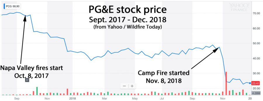
A dozen of the fires that started in Northern California around October 8, 2017 have been blamed on PG&E’s electrical equipment, according to CAL FIRE Investigators, who also are looking into power line equipment failures that may have caused the Camp Fire on November 8, 2018. Over 40 people died in the Northern California fires, and 86 perished in the Camp Fire. More than 14,000 homes were destroyed in the Camp Fire.
Shortly after both events the stock price of PG&E dropped precipitously, sinking 66 percent over the 13-month period. It took several days in 2017 for word to spread that the company appeared to be liable for the Northern California fires, but the sell-off began the day after the Camp Fire started in 2018. Investors are worried that the utility could be on the hook for billions of dollars in civil damages in addition to criminal penalties.
Below is an excerpt from the Sacramento Bee:
The legal brief submitted by [Attorney General Xavier] Becerra’s office said prosecutors would have to gauge PG&E’s “mental state” before determining which charges, if any, to bring. The charges would range from murder to a misdemeanor negligence charge, according to the brief. Becerra’s brief is purely advisory; if any criminal charges are filed, they would likely be lodged by county district attorneys, not the state. So far, though, district attorneys have shown little appetite for prosecuting PG&E, according to Sacramento Bee reporting. No charges have been filed yet in the wine country fires. And at least one DA has opted for a financial settlement in lieu of criminal prosecution
The 54,000-acre fire became the third largest in the recorded history of South Dakota
Legion Lake Fire December 12, 2017. Photo by Bill Gabbert.
A telephone company that is being sued by landowners for allegedly causing the Legion Lake Fire claims the 54,000-acre fire was caused by an “act of God”.
There is no question that a tree falling on a Black Hills Energy power line created sparks which ignited the fire December 11, 2017 in Custer State Park in the Black Hills of South Dakota. Three families claim in the lawsuit that Mt. Rushmore Telephone Company weakened the root system of the Ponderosa pine by digging a utility trench, making it less resistant to strong winds which were present when the fire started.
Below are excerpts from an article in the Rapid City Journal:
In its response, attorneys for Black Hills Energy deny almost everything in the pleading documents, save that a tree fell on a company power line. BHE contests their liability and suggests the plaintiffs themselves should be viewed as equally if not more guilty for their damage in the Legion Lake Fire. “Plaintiffs failed to mitigate their damages,” attorneys for Black Hills Energy write, “and any damages resulting from Plaintiffs’ failure to mitigate their damages may not be recovered.” Mt. Rushmore Telephone Company’s response is even shorter, arguing the Legion Lake Fire was “the result of an act of God.”
The 10,000 acres of private land that burned in the fire is used for raising cattle and many land owners lost pastures, fences, and winter hay.
More than half of the portion of Custer State Park that was available for their bison herd burned, and park officials asked for hay donations to help the animals get through the winter. Over 8,000 acres of Wind Cave National Park also burned in the Legion Lake Fire and in the earlier Rankin Fire, but park spokesperson Tom Farrell said they still had plenty of forage in reserve for the 260 elk and 350 bison.
Legion Lake Fire, December 13, 2018. Photo by Bill Gabbert.
Jurisdictions need to develop standards for structures, the home ignition zone, and community infrastructure
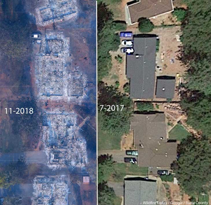
A neighborhood on Debbie Lane in Paradise, California, before and after the Camp Fire that started November 8, 2018. The homes were 14 to 18 feet apart.
In the weeks after 86 people were killed and over 14,000 homes and businesses were destroyed in the Camp Fire at Paradise, California three influential individuals and organizations urged the consideration of banning or restricting development in areas that are at high risk from wildfires.
First there was the Los Angeles Times Editorial Board on November 24 writing that “To rebuild Paradise as it was, would be land-use malpractice.” The Board continued, “The question facing state and local authorities is whether Paradise — and other towns that have burned — can be rebuilt to withstand the next, inevitable wildfire. If not, how does California relocate communities and restrict new construction while respecting property rights and not worsening the state’s affordable housing crisis? At a minimum, cities should remap fire-prone areas and focus reconstruction in areas with lower risk. “
Then on December 10 the group 1000 Friends of Oregon released “A New Vision for Wildfire Planning” that recommended avoiding development in high risk areas.
Chief Ken Pimlott, March 22, 2016. Photo by Bill Gabbert.
Five days before he retired on December 15 Ken Pimlott, Director of the California Department of Forestry and Fire Protection, was quoted by the Associated Press as saying officials should consider banning home construction in areas vulnerable to wildfires.
Cities, counties, and planning boards (where they exist) are often under pressure to approve new housing developments. They want to expand their tax base. Developers try to fit as many homes into a new subdivision as possible to maximize their investment. This too often results in homes that are 20-feet apart. If one is ignited by a burning ember that may have traveled a quarter of a mile from a fire (or a burning home) the radiant heat alone can ignite the homes on both sides. Then you can have a self-powered conflagration spreading house to house through a city. As long as the structures are that close together, the homeowners have not reduced the fuel in the Home Ignition Zone within 100 feet of the structure, and the home itself is not built to FireWise standards, a massive disaster can be the result.
The NFPA and the FireWise program recommend reducing flammable material within 100 feet of structures, and spacing trees at least 18 feet apart that are within 30 feet of the home. At the 60 to 100-foot distance tree canopies should be at least 6 feet apart. Another house that is 15 to 50 feet away is also fuel and if it ignites will be a serious threat.
If a homeowner wants, or is required, to reduce the flammable material within 100 feet of their residence, what are they expected to do if there is another home 20 feet away that is really a large assembly of flammable material?
Some of the homes in Paradise, California that burned were less than 20 feet apart. According to measurements using Google Earth, the structures in the photo at the top of this article were 14 to 18 feet from each other.
Photo: Anchor Point Group, Boulder, CO
The National Institute of Standards and Technology released a report on the Waldo Canyon Fire that burned 344 homes and killed two people in Colorado Springs, Colorado in June, 2012. They concluded that current concepts of defensible space did not account for hazards of burning primary structures, hazards presented by embers, and the hazards outside of the home ignition zone. In addition, NIST recommended:
High-density structure-to-structure spacing in a community should be identified and considered in [Wildland Urban Interface] fire response plans. In the Waldo Canyon fire, the majority of homes destroyed were ignited by fire and embers coming from other nearby residences already on fire. Based on this observation, the researchers concluded that structure spatial arrangements in a community must be a major consideration when planning for WUI fires.
After studying the Carr Fire that destroyed 1,079 residences at Redding, California earlier this year, retired CAL FIRE Battalion Chief Royal Burnett reached similar conclusions.
It was easy to figure out why the houses on the rim burned — they were looking right down the barrel of a blowtorch. Even though they had fire resistant construction, many had loaded their patios with flammable lawn furniture, tiki bars and flammable ornamental plants. Palm trees became flaming pillars, shredded bark became the fuse, junipers became napalm bombs. Under current standards houses are build 6 to an acre; 10 feet to the property line and only 20 feet between houses. Once one house ignited, radiant heat could easily torch the next one.
We have to learn to live with fire
Reducing the chances that a fire in a populated area will turn into a disaster that burns thousands of homes involves at least three categories of factors, in addition to weather:
Envelope of the structure itself: characteristics of the roof, vents, siding, doors, windows, foundation, fences, eaves, and decks. A FEMA publication (13 MB) has excellent detailed recommendations. Headwaters Economics found that the cost of building a fire-resistant home is about the same as a standard home.
Home Ignition Zone, as described above — topography and fuel within 100 feet.
Community infrastructure and planning: distance to nearby structures, evacuation capability, safety zones, road and driveway width, turnarounds at the end of roads, signage, and emergency water supply. Again, the FEMA document has great recommendations.
Someone asked me recently what needs to be done to keep from repeating disasters like we have seen within the last year at Paradise, Redding, and the Napa Valley. I told him that there is no one thing that needs to be done, such as raking or “forest management”, it requires a comprehensive holistic approach.
The items we have listed here only apply within communities. There is of course much that can be done surrounding the places where people live that would reduce the vegetation or fuel and decrease the intensity and ember generation potential of a fire as it approaches an urban area. Large scale fuel management including fuel breaks and prescribed fire programs are usually conducted by state and federal agencies.
The weakest link in the chain principle applies here. If one of these categories is sub-par, the individual structures and the entire community in a fire-prone environment is at risk. And if a homeowner does not do their part, it can endanger their neighbors.
The warming climate is demonstrating that wildfires are becoming increasingly perilous. It is unlikely that local governments or states are going to ban development in fire-prone environments, but it is their responsibility to protect their citizens by enacting sensible standards.
Imagery from GOES 16 showed dramatic smoke plumes from the Camp Fire
Screenshot from the GOES 16 time-lapse of the Camp Fire.
The NASA article below lays out how the agency believes the imagery from recently launched satellites can assist in the detection and management of wildfires.
GOES-16, operating as NOAA’s GOES East satellite, is proving to be an invaluable asset in detecting wildfires and helping forecasters provide proactive tactical decision-support services. The satellite’s main instrument, the Advanced Baseline Imager (ABI), offers three times more spectral channels, four times increased resolution, and five times faster coverage than the previous GOES imager. This means a much more detailed look at fire conditions, faster detection of hot spots, and the ability to track fire progression and spread in real time.
National Weather Service (NWS) incident meteorologists (IMETs) are using GOES-16 data to assist firefighting efforts. IMETs who deploy to wildfires are instrumental to the mission. An IMET’s first priority is to keep firefighters and the public safe amid rapidly changing wildfire conditions. During the peak of the Camp Fire in northern California in November 2018, the fire was advancing at a rate of over 100 football fields every minute. A shift in the winds could easily put firefighters in danger.
GOES East captured imagery of the Camp Fire in northern California on November 8, 2018. The wildfire developed in the early morning hours and spread quickly within very windy and dry weather conditions. Hot spots and a large plume of smoke are seen in this fire temperature RGB (red-green-blue) imagery is created with Advanced Baseline Imager bands 7, 6, and 5 (shortwave and near infrared bands), which are used to detect hot spots. To make this animation, the fire temperature imagery is made partially transparent and placed over a GeoColor enhancement, so both the fire’s hot spots and smoke plume are visible.
Timely satellite imagery is critical, life-saving information in a dynamic fire environment. In the past, IMETs had a single low-resolution image that updated every 15 minutes – typically the image was already 20 minutes old when it arrived to the forecaster. Now, GOES-16 frequently detects fires before they are spotted on the ground – often 10 to 15 minutes before emergency notifications to 911.
Alex Hoon, the NWS IMET for both the Camp and Carr Fires in California in 2018, says GOES-16 is crucial to an IMET’s mission to protect lives and property. “Now, forecasters are able to get incredible high-resolution images of the fire every single minute in the field, directly supporting firefighters who are engaged in the fire. Not only is this helping firefighters to more effectively fight fire, but more importantly, it’s helping to keep firefighters safe so that they can also come home to their families,” said Hoon.
GOES-16 is also used to pinpoint the exact location of a fire after reports of smoke. On July 2, 2018, the Pueblo County, Colorado, Emergency Management Office called the NWS Pueblo Weather Forecast Office (WFO) for assistance locating the source of smoke reported near Custer/Fremont/Pueblo County lines. GOES-16 showed a hotspot in northeast Custer County and the Pueblo WFO was able to provide the exact coordinates of what would become the Adobe Fire. Being in a remote and wooded area, the early and more precise geolocation of the fire was helpful for getting crews on the scene quickly.
GOES-16 observations are not just valuable for detecting wildfires but are also critical to observing and monitoring smoke from those fires. GOES-16’s ability to monitor smoke plumes in near-real time is particularly useful in directing firefighting efforts from the air. Deploying airplanes and helicopters to spray fire retardant is often hampered due to poor visibility. GOES-16 can help guide decisions for deploying flights by providing information on the exact location and motion of smoke from a fire. The smoke detection and monitoring information also enable better air quality forecasts.
The benefits from GOES-16 aren’t just seen during a fire but are also important in monitoring burn scars and predicting flash flood events from rain events after a fire. GOES-16 provides critical data for the entire lifecycle of a fire disaster – from drought to fire to floods and landslides.
The new capabilities from GOES-16 are a game-changer for fire weather forecasts and warnings. Soon, GOES-16 will be joined by its twin satellite, GOES-17, as NOAA’s operational GOES West. GOES-17 will provide even better resolution for U.S. West Coast firefighting efforts than GOES-16 due to its location over the Pacific Ocean.
New channels on the ABI provide more information to forecasters and the high resolution and rapid scanning give them high-definition images as often as every minute. Data from the ABI is helping forecasters locate hotspots, detect changes in a fire’s behavior, predict a fire’s motion, and monitor the post-fire landscape like never before. Providing this information to firefighters, emergency managers, and state and county agencies helps NOAA’s Satellite and Information Service meet its mission of protecting the nation’s environment, security, economy and quality of life.