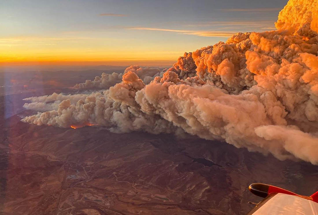
East Troublesome Fire October 21, 2020 as seen from Colorado’s Multi-Mission Aircraft.
The East Troublesome Fire, the second largest wildfire in Colorado’s recorded history, was human caused, investigators said on Friday.
The October, 2020 fire burned 193,812 acres in Grand County. It created spot fires across the Continental Divide then spread to within a few miles of the town of Estes Park.
“Based on evidence gathered at the fire’s origin, investigators have determined the fire to be human caused,” the U.S. Forest Service said in a news release.
The Steamboat Pilot reported that the Grand County Sheriff’s Office released similar information during a meeting in March 2021, but this is the first time the Forest Service has issued it.
Saying it was human caused eliminates two possibilities — lightning and a volcano, which can often be ruled in or out very quickly. The USFS news release said their investigators, along with the Grand County Sheriff’s Office, are continuing to investigate.
Map of the East Troublesome Fire near Estes Park.
“Given the location and time of year that the fire started, it may have been caused by a hunter or a backcountry camper, and possibly by accident,” investigators said in a news release on Friday.
More than 300 homes and between 100 and 200 other structures were destroyed in the blaze. Lyle and Marylin Hileman, 86 and 84, respectively, died in the fire when their home near Grand Lake burned.
The largest wildfire in Colorado in terms of acres burned was the Cameron Peak Fire. It burned 208,913 acres in 2020 in Larimer and Jackson counties, Arapahoe and Roosevelt National Forest, Rocky Mountain National Park, and surrounding communities.
“Friday’s expected weather could rival the most powerful fire events of the past decade,” said a NWS meteorologist
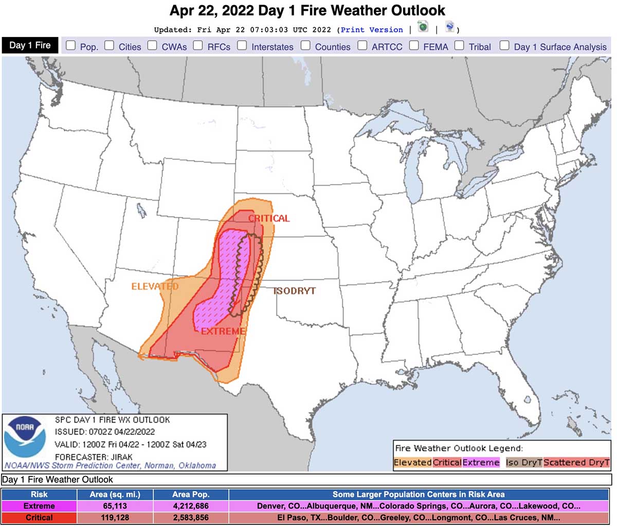
Updated 7:22 a.m. MDT April 22, 2022
Critical and Extreme fire weather predicted by the Storm Prediction Center for 6 a.m. Friday to 6 a.m. Saturday, April 22 & 23, 2022.
The Storm Prediction Center has issued a Fire Weather Outlook for 6 a.m. MDT Friday April 22 until 6 a.m. MDT Saturday April 23 that uses language we rarely see in a fire weather forecast, including “extremely critical” and “dangerous”.
The forecast warns about extremely critical fire weather conditions in portions of central and eastern New Mexico and eastern Colorado, and critical fire weather for portions of the southern and central high plains.
Sustained winds out of the south-southwest at 30 to 40 mph with widespread gusts of 50-60 mph are expected with 5 to 15 percent relative humidity. The fuels are exceptionally dry and isolated thunderstorms with little or no rain are possible in some areas.
Three existing fires in northern New Mexico east and northeast of Santa Fe could be vulnerable to extreme conditions, the Cooks Peak Fire, Calf Canyon Fire, and the Hermits Peak Fire. Friday’s forecast for the Calf Canyon Fire, which was very active Thursday, calls for southwest winds of 46 mph gusting to 64 mph with relative humidity in the teens and 20s. It will also be very windy on Saturday.
In Northern New Mexico the wind speeds will increase through the morning, peaking in the afternoon.
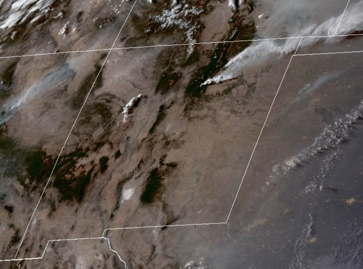
Satellite photo showing smoke from the Cooks Peak and Hermits Peak Fires in northern New Mexico at 6:30 p.m. MDT April 21, 2022. NOAA.
CNN is taking this forecast seriously in an article written by four of their meteorologists. Here are some excerpts:
Friday’s expected weather could rival the most powerful fire events of the past decade, Zach Hiris, a meteorologist at the National Weather Service office in Boulder, Colorado, told CNN.
Compared to recent extremely critical, wind-driven fire dangers in rural areas, some major population centers are threatened in this event, including Albuquerque, New Mexico, and Colorado Springs and the Denver metro area in Colorado.
“There is high confidence that a widespread extreme and potentially catastrophic fire weather event will occur on Friday,” said the National Weather Service office in Albuquerque.
In addition to fueling the fires, widespread wind gusts of 60 to 70 mph — and even 80 mph in scattered areas — could knock down large tree limbs, utility poles and other structures while threatening to topple high-profile vehicles, the weather service said.
Here is the forecast produced by the NOAA Storm Prediction Center at 12:20 p.m. MDT Thursday April 21:
Day 1 Fire Weather Outlook
NWS Storm Prediction Center Norman OK
0202 AM CDT Fri Apr 22 2022
Valid 221200Z – 231200Z
…EXTREMELY CRITICAL FIRE WEATHER AREA FOR PORTIONS OF CENTRAL AND EASTERN NEW MEXICO INTO EASTERN COLORADO… …CRITICAL FIRE WEATHER AREA FOR PORTIONS OF THE SOUTHERN AND CENTRAL HIGH PLAINS…
…Synopsis… ***DANGEROUS FIRE-WEATHER CONDITIONS EXPECTED TODAY ACROSS PORTIONS OF EAST-CENTRAL NEW MEXICO INTO EASTERN COLORADO***
A highly amplified large-scale trough and accompanying intense deep-layer south-southwesterly flow will emerge over the southern Rockies and adjacent High Plains by peak heating. As a result, strong cyclogenesis will occur over far northeastern Colorado during the afternoon, with a sharpening dryline extending southward along the Kansas/Colorado border and the Texas/New Mexico border. The combination of a strong surface pressure gradient, hot/dry conditions behind the dryline, and strong south-southwesterly flow aloft will result in extremely critical fire-weather conditions from east-central New Mexico into eastern Colorado today.
…East-central New Mexico into eastern Colorado… As temperatures climb into the upper 70s to middle 80s behind the sharpening dryline, deep boundary-layer mixing into very dry air aloft will result in widespread 5-15 percent minimum RH. At the same time, 30-40 mph sustained south-southwesterly surface winds (with widespread gusts of 50-60 mph) will overspread critically dry fuels (ERCs above the 90th+ percentile). The volatile combination of very strong/gusty winds, anomalously warm/dry conditions, and near-record dry fuels will encourage extreme fire-weather conditions.
…Remainder of the central and southern High Plains… The eastern extent of critical fire-weather conditions will be demarcated by the placement of the dryline. Strong 30+ mph sustained southerly surface winds (with higher gusts) concurrent with afternoon RH values below 20% will extend into southern New Mexico, West Texas, the western Texas/Oklahoma Panhandles, western Kansas, and western Nebraska — where fuels remain critically dry.
…Dry Thunderstorm Potential… Another point of concern will be isolated dry thunderstorm development immediately along and ahead of the dryline this afternoon, which is expected to take place along the axis of the driest fuels. Any cloud-to-ground lightning flashes that can occur in proximity to the Colorado/Kansas and New Mexico/Texas border area will do so over very receptive fuels, and likely with little wetting rainfall at the early stages of thunderstorm evolution.
..Jirak.. 04/22/2022
(end of forecast)
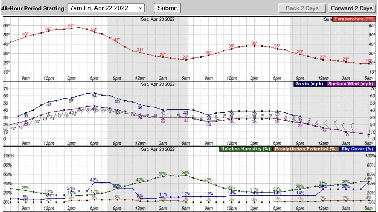
Below is the forecast for the area near the Calf Canyon fire 23 miles east of Santa Fe.
Weather forecast for the Calf Fire area, 7 a.m. MDT April 22, 2022.
The fire has burned 189 acres south of the Mesa Laboratory of the National Center for Atmospheric Research, on the southwest side of the city
10:55 a.m. MT, March 27, 2022
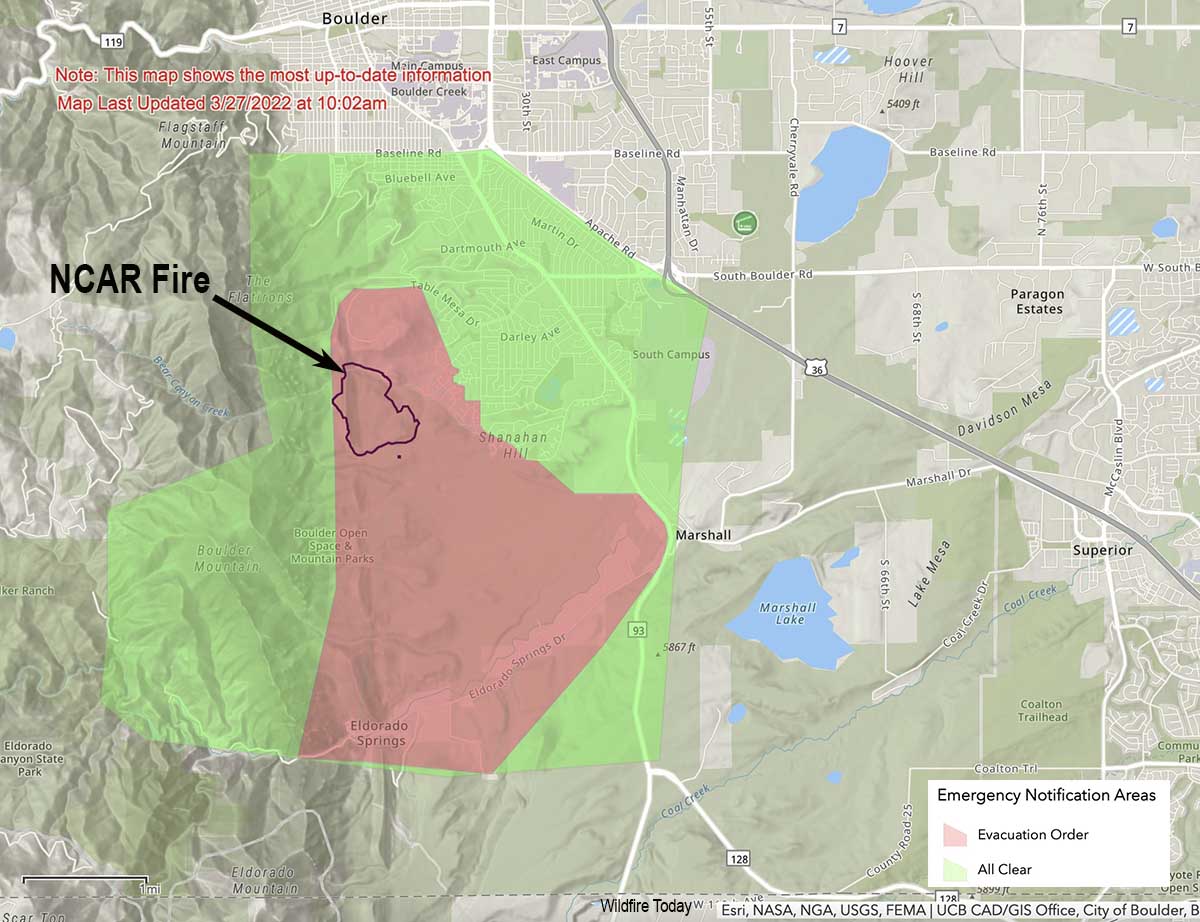
Map showing the perimeter of the NCAR Fire at 10:02 a.m. March 27, 2022. The evacuation area is shown in red.
The NCAR Fire that started at about 2:08 Saturday afternoon on the southwest edge of Boulder, Colorado initially required the evacuation of 19,000 people and 8,000 homes. By early Sunday morning the blaze had slowed and the evacuation area had been reduced, affecting 1,629 people and 699 housing units. The fire was mapped Sunday morning at 189 acres. They are calling it 21 percent contained.
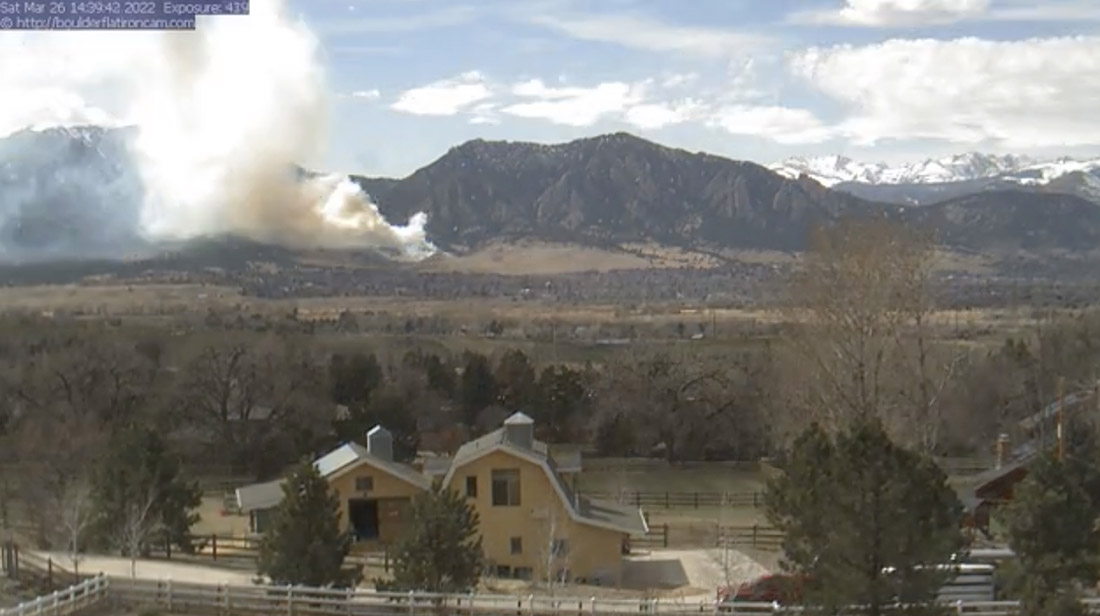
Smoke from the NCAR fire, 2:39 p.m. MT March 26, 2022. Image from Louisville Cam.
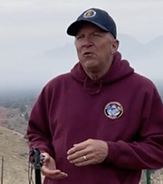
Regarding the status of the fire, Incident Commander Mike Smith of Boulder Fire Rescue said Sunday morning, “I think right now we’re in a good position. The wind speeds are nothing like they were during the Marshall Fire, we’ve got a lot of good resources in place, we have full structure protection groups as well as assets up on the hill. I think as long as the weather does what it is supposed to do today and tomorrow we’re gonna be in good shape.”
The fire came within 1,000 yards of homes on the southwest side of Boulder, but no structures have been destroyed. The incident is near the Mesa Laboratory of the National Center for Atmospheric Research (NCAR).
The Marshall Fire, pushed by winds gusting at 60 to 100 mph, on December 30 spread rapidly as it destroyed more than 1,000 homes. Most were in the city of Louisville and the town of Superior. It started about 4 miles southeast of the NCAR Fire.
Mr. Smith said there have been no injuries. The cause is under investigation but the area of origin has been identified as being on the northwest side of the fire in the Bear Canyon/Bear Creek area.
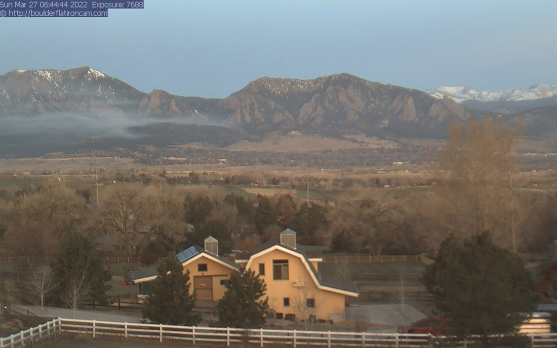
Smoke from the NCAR fire, 6:44 a.m. MT March 27, 2022. Image from Louisville Cam.
Resources available on the fire Sunday will include 110 personnel, 2 fixed wing air tankers, and one helicopter. Initially on Saturday over 200 firefighters from about 30 agencies responded.
The plan for today is to reinforce the fire line and “corral the fire up into the rocks and snow”, Mr. Smith said. The evacuation areas will be reevaluated today.
Mike Smith, Incident Commander on the NCAR Fire, speaks to reporters, at 9 a.m. Sunday, March 27, 2022.
“Good planning, good prep, and a lot of good mitigation work are the reasons why we had good success today,” said Incident Commander Mike Smith. “The forecast today is for north and northwest winds which is a little less favorable [than in an earlier prediction] but the wind speeds are not that high, 15 maximum to 20. We have the plan in place to create more evacuations [if necessary], our hope is that we don’t have to do any of those.”
Some nearby water reservoirs were frozen and were not available for firefighting helicopters as a source of water, according to @mitchellbyars, a reporter with the Daily Camera.
The forecast for Monday in the fire area is for 80 degrees, very low humidity dropping to 10 percent, and light winds ranging from 5 to 12 mph out of the southwest.
The intensity of this fire in a few places was pretty high, Mr. Smith said, but for the most part it was a pretty low intensity fire. He was also the Incident Commander on the Marshall Fire.
“Between aggressive initial attack and having the aviation assets, the single engine air tankers being able to put some retardant down in between the homes was a real benefit,” said Mr. Smith.
On the Marshall Fire strong winds prevented aircraft from dropping water or retardant as homes were burning.
When asked by a reporter, “It’s been a long year — how are you feeling?” Mr. Smith replied, “It’s March but it feels like it’s November. No, we’re doing good. We’re nervous about the season coming up. When you look at the long term forecast for the upcoming season I think this is just a sign of the way things are going to go…We only have 365 fire days a year,” he said with a smile.
Cherry Canyon Fire, 58 miles east-northeast of Trinidad, Colorado, May 24, 2020. Photo: Colorado Fire Prevention & Control.
A television station in Denver, 9News, reports that some firefighters in the state, especially volunteers, do not have the necessary personal protective equipment (PPE) to reduce their risks when fighting fires.
A bill recently passed by the legislature that appropriates $5 million to help provide the gear is waiting on the Governor’s desk for a signature.
The additional funding will most likely address PPE for all types of fires, including self contained breathing apparatus for hazardous material incidents and structure and vehicle fires. As Wildfire Today reported December 22, 2021, a recent survey conducted by the NFPA asked 26,000 fire departments of all sizes about their readiness and capability for suppressing wildland fires. Here are three of the questions.
Excerpt from the Wildland Fire section of the NFPA Needs Assessment.
Cameron Peak Fire smoke plume at Boyd Lake, InciWeb, Oct. 14, 2020.
In an effort to improve forest resilience and reduce the risk of catastrophic wildfires in the Interior West, three organizations are receiving a total of $20 million from the U.S. government.
The funds are part of the Infrastructure Investment and Jobs Act passed by Congress with bipartisan support and signed by President Joe Biden in 2021, which will go to enhancing key systems and processes to mitigate the impact of forest fires.
The award will be made to the Southwest Ecological Restoration Institutes (SWERI) which includes the Colorado Forest Restoration Institute (CFRI), Highlands University’s New Mexico Forest and Watershed Restoration Institute, and Northern Arizona University’s Ecological Restoration Institute. The SWERI were created through congressional legislation passed in 2004 which charged the three institutes with promoting adaptive management practices to restore the health of fire-adapted forest and woodland ecosystems of the Interior West.
The Colorado Forest Restoration Institute is housed in the Department of Forest and Rangeland Stewardship in CSU’s Warner College of Natural Resources.
The three institutes will work collaboratively on three key components with the funding, to:
Develop a national database of existing data on fuel treatments and wildfires,
Work with managers, planners, and policymakers to facilitate use and applications of the data, and,
Research outcomes of forest management and wildfires to learn what works.
“The work we’re charged with developing under the Infrastructure measure will create opportunities for land and fire managers, scientists and community stakeholders to co-produce actionable knowledge to lessen the harmful effects of wildfire events to people and the environment,” said Tony Cheng, director of the CFRI and professor in the Department of Forest and Rangeland Stewardship.
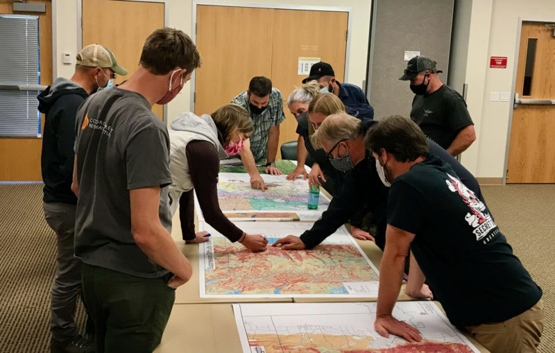
Land and fire managers and community stakeholders in Boulder County huddled around CFRI geospatial mapping products aided by CFRI’s science and outreach staff. Photo by Tony Cheng.
According to Cheng, the new funding aligns with the CSU land-grant mission and offers an opportunity to grow CFRI’s existing data management, application, and research efforts to be accessible for a wider audience.
The funding is prompted by climate change-driven increases in fire activity and fire season length, continued development in the wildland-urban interface, and interactions between fire and disturbances like pest and pathogen disturbance.
The CFRI recently completed a statewide database of forest vegetation management and wildfires for Colorado, complementing a similar effort for New Mexico and southern Colorado led by the New Mexico Forest and Watershed Restoration Institute. The data serve as a foundation for the decision support tools and collaborative processes that CFRI deploys around the state and throughout the Interior West. The national database will be developed using similar types of data across the country.
The data are only the starting point, said Brett Wolk, one of CFRI’s assistant directors. Making data meaningful for land and fire managers, scientists, policymakers, and community stakeholders working in their specific places is a critical function the institutes excel at and is called out in the Infrastructure provisions.
“Unless the data is situated within a social context where people can understand how it applies to their work, all the best data and science in the world won’t change decisions or outcomes on the ground,” said Wolk. “That’s why SWERI works to co-develop solutions with partners and empower decisions that are science informed but also locally relevant.”
A third component of the funding is researching outcomes of past treatments to improve future decisions. This will build on deep research expertise at the Arizona and Colorado institutes, exemplified by a recent CFRI co-led publication and accompanying podcast evaluating accomplishments of the Forest to Faucets partnership aimed at protecting Denver’s water supply from devastating wildfires.
The challenge, Wolk said, is applying the collective institutes’ knowledge and expertise across the entire U.S. At the same time, there is an opportunity for other states to benefit from the collective knowledge across the institutes.
“It’s a massive opportunity to help fast-track implementation of what’s working in forest and fire management. But research also shows big gaps in who has access to and contributes knowledge towards these forestry data and decision-making processes. If we can increase the application of science, while making incremental change to expand equity of ideas and resources among wider audiences, those will be our measures of success.”
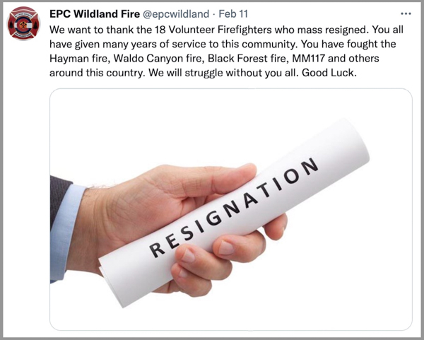
A tweet posted on the crew’s account said 18 volunteers “mass resigned”
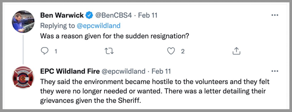
A message posted February 11 on the Twitter account of the Wildland Fire Crew in El Paso County Colorado stated that 18 volunteer firefighters on the crew “mass resigned.” A follow up tweet read, “They said the environment became hostile to the volunteers and they felt they were no longer needed or wanted.” El Paso County is the location of Colorado Springs.
The El Paso County fire crew is part of the County Sheriff’s office which is headed by Sheriff Bill Elder. In Colorado and Wyoming the sheriff is responsible for the suppression of wildfires occurring in the unincorporated areas of the county outside the boundaries of a fire protection district. In Texas this role is assigned to the County Judge.
In a response to the tweets about the resignations, the Sheriff’s office issued a response to what they described as the “unauthorized, inaccurate tweet from the EPC Wildland Fire Twitter Account.” The response, posted below, said, “While there have been some resignations by members of the EPC Wildland Fire Team, the information posted was not accurate.” The statement did not specify what was inaccurate in the tweets about the resignations.
[pdf-embedder url=”https://wildfiretoday.com/wp-content/uploads/2022/02/MR-22-006-Sheriffs-Office-Addresses-Unauthorized-Inaccurate-Tweet-from-the-EPC-Wildland-Fire-Twitter-Account.pdf” title=”El Paso County Sheriff response to mass resignations wildland fire crew”]
El Paso County has been the location of some devastating wildfires in the last 20 years. In 2012, the Waldo Canyon Fire burned more than 18,000 acres, destroyed 347 homes in Colorado Springs, and killed two people. Almost exactly a year later, the Black Forest Fire ignited east of the city and burned more than 15,000 acres, 486 homes, and killed two people. The Hayman Fire in 2002 blackened 137,760 acres and destroyed 133 homes. In 2018 the MM 117 Fire burned 41,000 acres and 23 homes.
(UPDATE Feb. 17, 2022: KRDO has an article saying the Sheriff’s office told them that 10 members of the fire crew quit.)
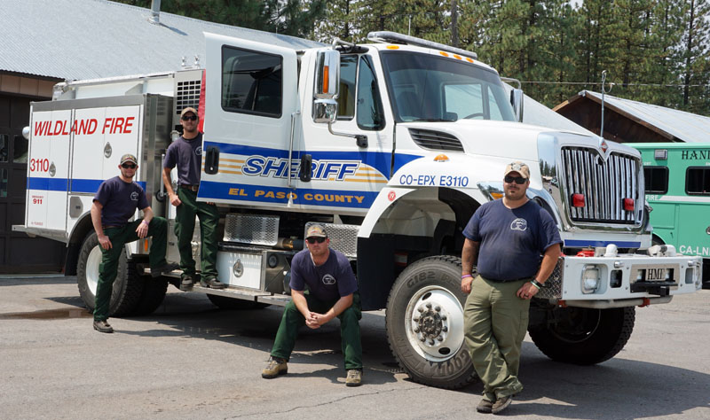
In 2014 while on a motorcycle trip that went through Northern California I took a photo of an engine crew from El Paso County that was staging in Chester.
El Paso County Sheriff’s Office engine crew in Chester, California, Aug. 16, 2014. L to R: Collin Wolff, Cameron Hammitt, Peter Ringen, and Captain David Yowell. Photo by Bill Gabbert.