36 air miles west-southwest of Socorro, New Mexico
Updated at 7 p.m. MDT May 2, 2022
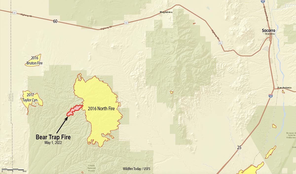
Map Bear Trap Fire May 1, 2022.
At noon on Sunday May 1 the Bear Trap Fire started in Bear Trap Canyon in the Cibola National Forest 36 air miles west-southwest of Socorro, New Mexico. At about 4 p.m. the Southwest Coordination Center tweeted that nine air tankers were working the fire — three Very Large Air Tankers (DC-10s) and six Large Air Tankers — plus four Air Tactical aircraft, a Type 3 Incident Management Team, one hand crew, and eight fire engines. That was an aggressive initial attack.
@VentanaRanch who was using an app to monitor the aircraft at the fire, Tweeted at 4:28 p.m., “Non-stop tankers from [Albuquerque] and Silver City.”
On Monday officials said the blaze had burned 1,209 acres. The fire behavior was described as moderate with isolated torching as it spread through pine, pinyon-juniper, and grass.
At 3 p.m. on Sunday the Magdalena weather station not too far from the fire recorded 10 mph winds out of the southwest gusting to 26, with 5 percent relative humidity. The weather forecast for the fire area on Tuesday calls for 25 mph winds out of the southwest gusting to 36 mph with 11 percent relative humidity. Similar conditions are predicted for Wednesday.
An air tanker drops on the Bear Trap Fire, San Mateo Mountains, New Mexico, May 1, 2022; . FS Photo by S. Matt Counts, Cibola NF, and Air Attack.
By Sunday night, based on a rough map of the perimeter, the head of the fire appears to have burned into the footprint of the North Fire which burned 42,000 acres in May of 2016. That fire was not fully suppressed, but the strategy of the Bear Trap fire is full suppression.
With about half a dozen other fires in Arizona and New Mexico, some of them very large, the Type 3 Incident Management Team which will assume command at 6 a.m. Tuesday may run into difficulty competing for firefighting resources.The teams on the Calf Canyon / Hermits Peak Fire and the Cerro Pelado Fire have listed as critically needed resources a total of 8 hand crews and 20 engines.
Bear Trap Fire, New Mexico, May 2, 2022; San Mateo Mountains. FS Photo by- S. Matt Counts, Cibola NF and Air Attack.
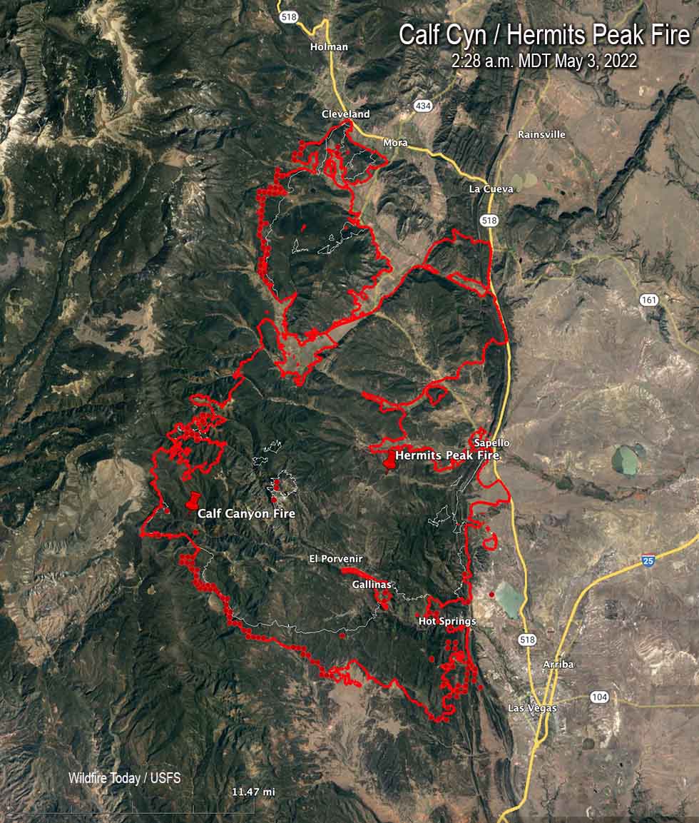
Map of the Calf Canyon / Hermits Peak Fire. The red line was the perimeter at 10:25 p.m. May 2. The white line was the perimeter about 24 hours before. The red dots represent heat detected by a satellite at 2:28 a.m. MDT May 3, 2022.
In spite of satellite photos showing massive amounts of smoke being generated by the Calf Canyon / Hermits Peak Fire, information released by the incident management team indicated that firefighters were able to make progress in several key areas of the fire on Monday. Large firing operations were conducted to widen fire lines and remove fuels ahead of a wind shift that could threaten communities.
The fire grew Monday to 145,854 acres, an increase of about 25,000 acres.
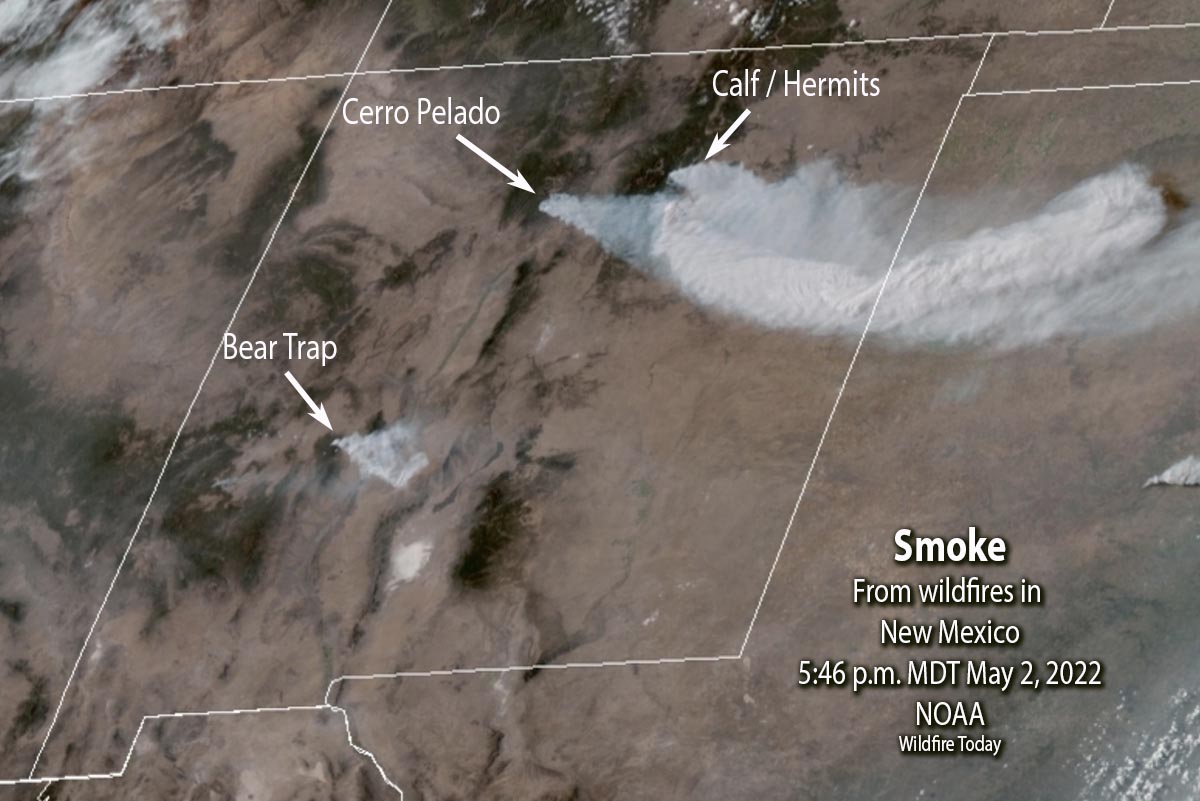
Satellite photo showing smoke created by wildfires in New Mexico, 5:46 p.m. MDT May 2, 2022. NOAA.
In addition to other aircraft, three DC-10 Very Large Air Tankers worked the fire Monday, dropping a total of nearly 28,000 gallons of retardant.
Structure protection crews have been removing fuels around buildings and securing lines around populated areas.
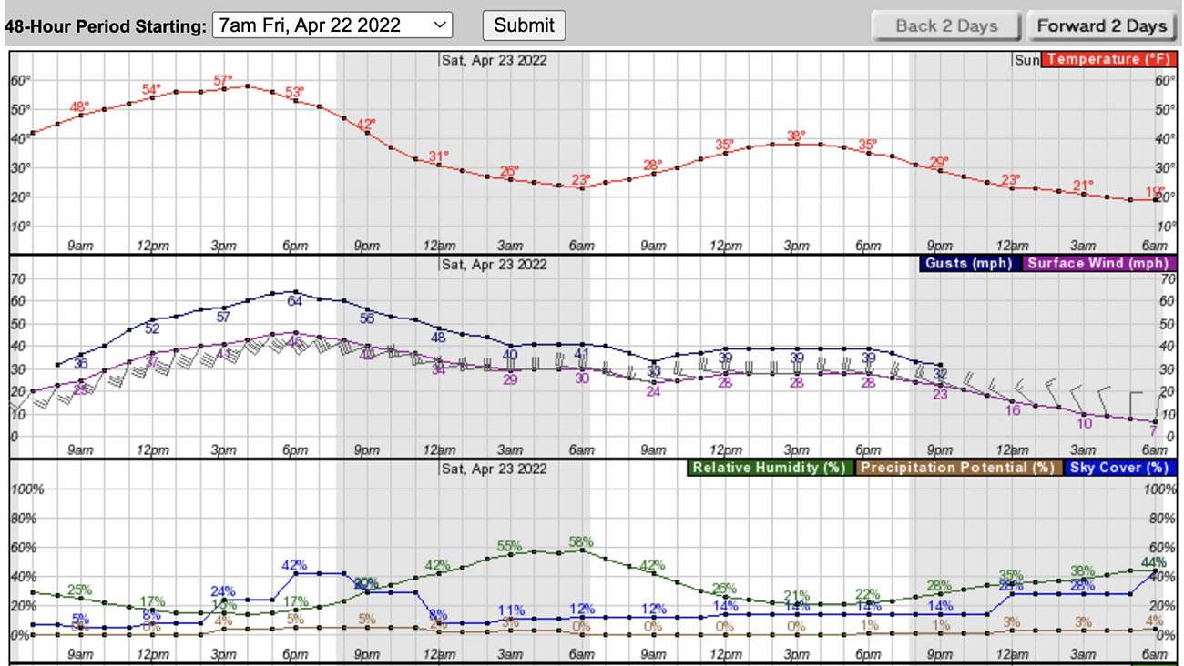
A Red Flag Warning is in effect Tuesday for nearly the entire state of New Mexico. The weather forecast is for 25 mph winds gusting out of the southwest at 37 mph with relative humidity of 12 percent. There is a slight chance of showers in the afternoon. On Wednesday the wind speeds will decrease to 20 mph from the west with the minimum humidity remaining at 12 percent.
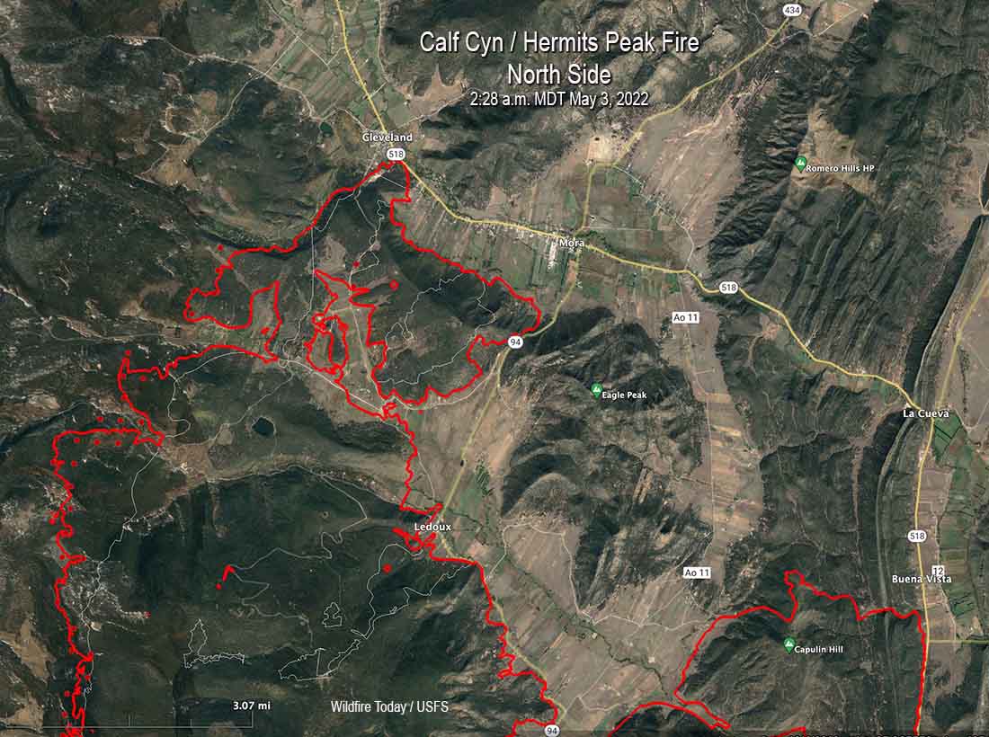
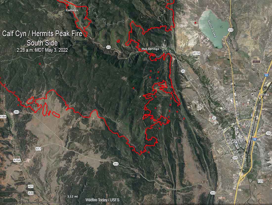
Below are maps of the north and south sides of the Calf Canyon / Hermits Peak Fire.
Map of the north side of the Calf Canyon / Hermits Peak Fire. The red line was the perimeter at 10:25 p.m. May 2. The white line was the perimeter about 24 hours before. The red dots represent heat detected by a satellite at 2:28 a.m. MDT May 3, 2022.Map of the south side of the Calf Canyon / Hermits Peak Fire. The red line was the perimeter at 10:25 p.m. May 2. The white line was the perimeter about 24 hours before. The red dots represent heat detected by a satellite at 2:28 a.m. MDT May 3, 2022.
Resources assigned Monday evening included 20 hand crews, 14 helicopters, and 89 fire engines for a total of 1,085 personnel.
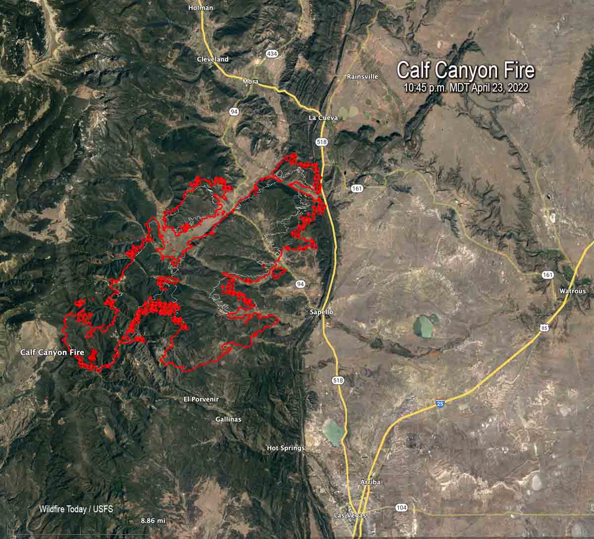
Map of the Calf Canyon Fire showing the perimeter in red at 10:45 p.m. MDT April 23, 2022. The white line was the perimeter about 24 hours before. The red dots represent heat detected by a satellite at 2:45 a.m. MDT April 24.
As the wind speeds decreased from the gale force conditions seen Friday, firefighters on the Calf Canyon and Hermits Peak fires that burned together were able to re-engage Saturday. The blazes are about 10 miles north of Las Vegas, New Mexico.
Crews are working on structure protection out ahead of the fire, removing fuel near homes in order to reduce their vulnerability. Dozers are putting in fire line where the terrain permits and the seven hand crews are working in steeper, less rocky areas.
Even though the fires have merged they are still being treated separately in reports. The combined size determined by a mapping flight at 10:45 p.m. Saturday was 54,004 acres.
“We don’t have enough resources to do everything we want to do at one time so we have to prioritize the resources we have at the right location,” said Incident Commander Carl Schwope in a briefing Saturday evening.
Hermits Peak Fire April 18, 2022 before it merged with the Calf Canyon Fire. By @jennalunaphoto
Reports filed Friday night showed that only seven hand crews were assigned and only one of those was a higher qualified Type 1 crew. A total of 526 personnel were on the fire.
The Incident Management Team that is handling both incidents has ordered “hundreds” of resources, but those orders can only be filled if the personnel and equipment are available.
As of Saturday evening the fire had not crossed the 518 road near the junction of road 161, but it was close and the fire was active in that area.
The Hermits Peak Fire was caused by a prescribed fire that escaped on the Santa Fe National Forest at 4:30 p.m. April 6, 2022. No cause has been released for the Calf Canyon Fire first reported on April 19.
Cooks Peak Fire
The Cooks Peak Fire nine miles south of Cimarron, NM was less active than the Calf Canyon Fire, but its spread was also slowed by a decrease in winds. A mapping flight Saturday night determined it had grown to 51,982 acres.
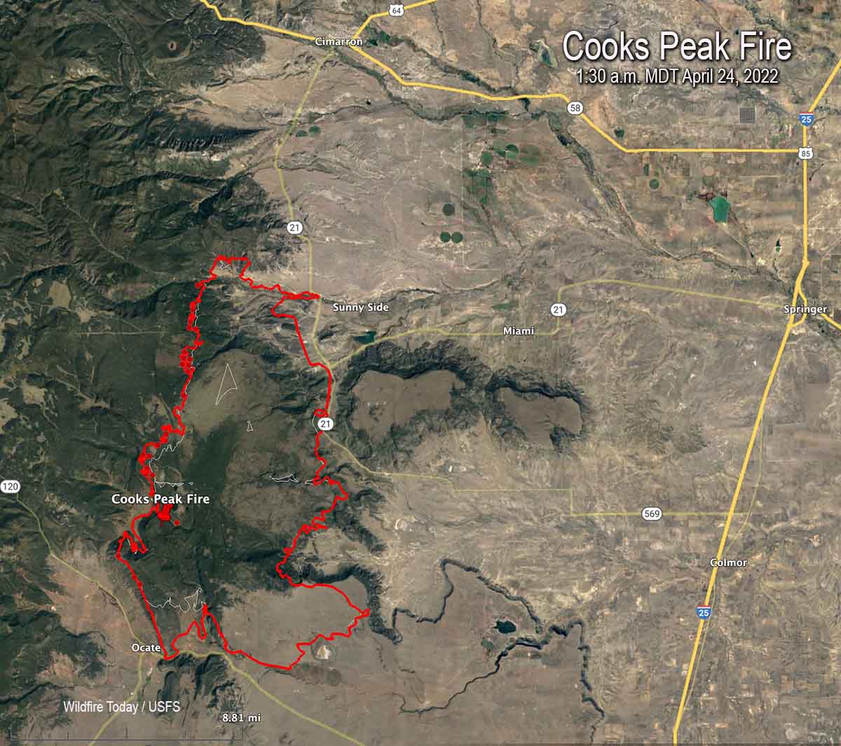
Map of the Cooks Peak Fire showing the perimeter in red at 1:30 a.m. MDT April 24, 2022. The white line was the perimeter about 24 hours before. The red dots represent heat detected by a satellite at 2:45 a.m. MDT April 24.
Reports submitted Friday evening showed there were only nine hand crews assigned, with one being a highest qualified Type 1 crew. A total of 383 personnel were on the fire.
8:26 a.m. MDT April 23, 2022
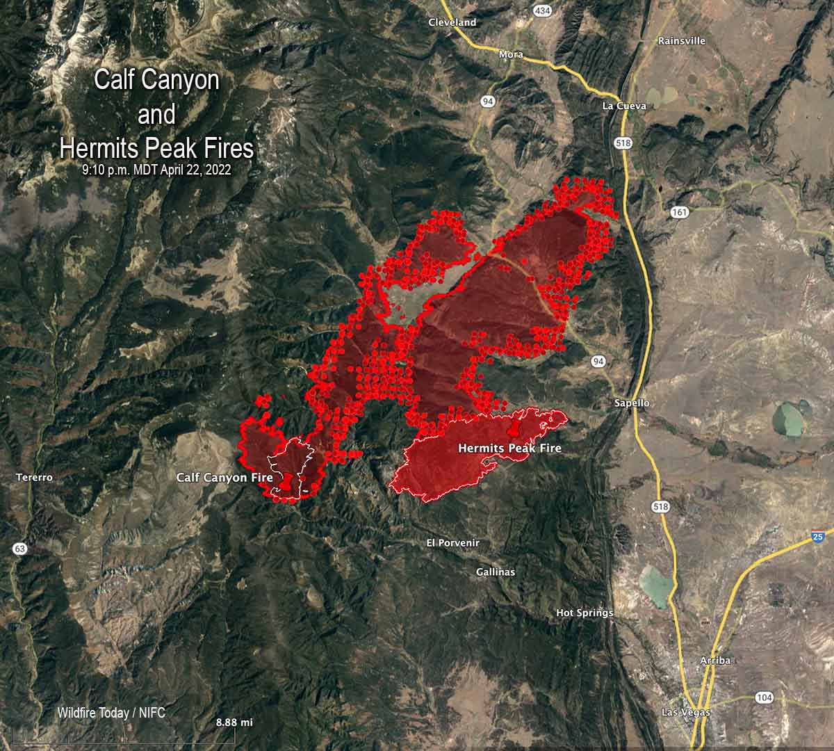
Map of the Calf Canyon & Hermits Peak Fires. The red lines were mapped by an aircraft at 9:10 p.m. MDT April 22, 2022. The white lines were the perimeters about 24 hours before. The red dots represent heat detected by a satellite as late as 3:07 a.m.
Strong winds and low humidities combined to cause two fires to merge and spread 10 miles through dry vegetation in Northern New Mexico Friday. A third fire was also very active. Those fires have now burned a total of approximately 88,000 acres.
Extreme fire weather predicted with wind gusts more than 50 mph
Updated 4:14 p.m. MDT April 22, 2022
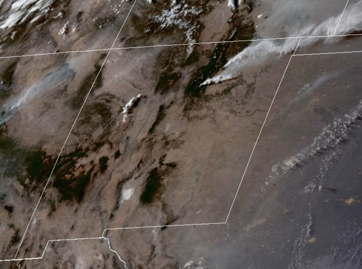
Satellite photo, showing smoke from the Cooks Peak and Calf Canyon Fires in New Mexico at 3:36 p.m. MDT April 22, 2022. NOAA.
Additional evacuations have been ordered for the Calf Canyon and the nearby Hermits Peak Fires in Northern New Mexico. They were posted at 1 p.m. April 22 by San Miguel and mora Counties in New Mexico. A map is available on Facebook but it is almost undecipherable. Below is a list of the areas affected.
Calf fire evacuations, 1 p.m. MDT April 22, 2022
The satellite photo above shows a large plume of smoke from the Calf Canyon Fire which was blowing northeast over the Cooks Fire when the photo was taken at 3:36 p.m. MDT Friday. It appears that pyrocumulus was forming over the Cooks Peak Fire, indicating extreme fire behavior.
At 3:04 p.m. MT Friday the Bartley weather station north of the Calf Fire recorded 17 mph winds gusting from the south at 35 mph. The relative humidity was 11 percent.
Smoke maps are posted in another article on Wildfire Today.
9 a.m. MDT April 22, 2022
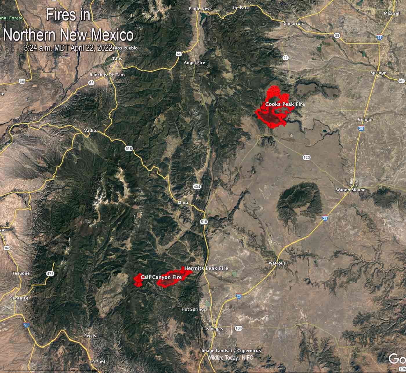
Map of fires in Northern New Mexico, 3:24 a.m. MDT April 22, 2022.
The critical and extreme fire weather predicted for areas in New Mexico and Colorado on Friday will affect the three existing wildfires in Northern New Mexico on Friday and Saturday.
The Calf Canyon and Hermits Peak Fires are 24 and 27 miles, respectively, east of Santa Fe, and are northwest of Las Vegas, NM.
The Calf Canyon Fire was very active Thursday, creating a large smoke plume as it spread primarily north and northeast. It was listed at 2,877 acres Thursday night.
The Hermits Peak Fire has been fairly quiet in recent days and is nearing containment. The strong winds will test the fire lines on the 7,573-acre blaze.
The 21,000-acre Cooks Peak Fire 13 miles south of Cimarron was also very active Thursday as it grew to the north and northeast.
The Storm Prediction Center’s forecast for Northeast New Mexico and Eastern Colorado on Friday is for “5-15 percent minimum RH. At the same time, 30-40 mph sustained south-southwesterly surface winds (with widespread gusts of 50-60 mph) will overspread critically dry fuels.” There is a chance for scattered thunderstorms with lightning and little or no rain.
The specific forecast for the Calf Canyon Fire calls for southwest winds of 46 mph gusting up to 64 mph with relative humidity in the teens and 20s. It will also be very windy on Saturday. Conditions on the Cooks Peak Fire will be similar, but with the humidity dropping into the single digits.
The southwest winds on Friday will shift to come out of the west-southwest Friday night, then from the west on Saturday. The speeds will decrease Friday night and Saturday, but will still be sustained in the mid-20s with gusts in the 30s.
These dangerous conditions will be conducive to significant spreading of the Cooks Peak and Calf Canyon Fires to the northeast and east.
Forecast for the area near the Cooks Peak Fire. NWS.
“Friday’s expected weather could rival the most powerful fire events of the past decade,” said a NWS meteorologist
Updated 7:22 a.m. MDT April 22, 2022
Critical and Extreme fire weather predicted by the Storm Prediction Center for 6 a.m. Friday to 6 a.m. Saturday, April 22 & 23, 2022.
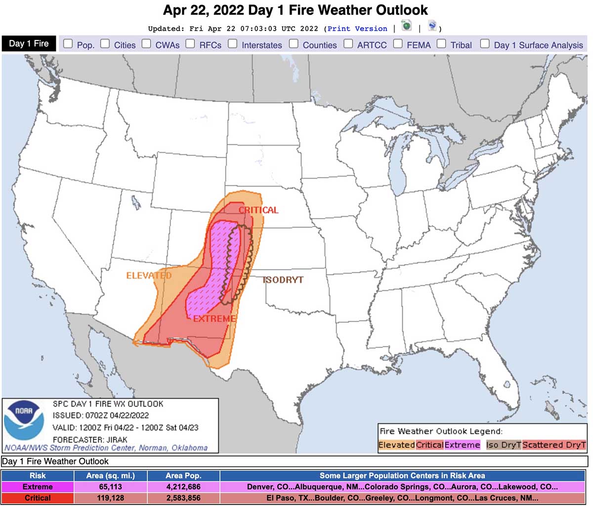
The Storm Prediction Center has issued a Fire Weather Outlook for 6 a.m. MDT Friday April 22 until 6 a.m. MDT Saturday April 23 that uses language we rarely see in a fire weather forecast, including “extremely critical” and “dangerous”.
The forecast warns about extremely critical fire weather conditions in portions of central and eastern New Mexico and eastern Colorado, and critical fire weather for portions of the southern and central high plains.
Sustained winds out of the south-southwest at 30 to 40 mph with widespread gusts of 50-60 mph are expected with 5 to 15 percent relative humidity. The fuels are exceptionally dry and isolated thunderstorms with little or no rain are possible in some areas.
Three existing fires in northern New Mexico east and northeast of Santa Fe could be vulnerable to extreme conditions, the Cooks Peak Fire, Calf Canyon Fire, and the Hermits Peak Fire. Friday’s forecast for the Calf Canyon Fire, which was very active Thursday, calls for southwest winds of 46 mph gusting to 64 mph with relative humidity in the teens and 20s. It will also be very windy on Saturday.
In Northern New Mexico the wind speeds will increase through the morning, peaking in the afternoon.
Satellite photo showing smoke from the Cooks Peak and Hermits Peak Fires in northern New Mexico at 6:30 p.m. MDT April 21, 2022. NOAA.
CNN is taking this forecast seriously in an article written by four of their meteorologists. Here are some excerpts:
Friday’s expected weather could rival the most powerful fire events of the past decade, Zach Hiris, a meteorologist at the National Weather Service office in Boulder, Colorado, told CNN.
Compared to recent extremely critical, wind-driven fire dangers in rural areas, some major population centers are threatened in this event, including Albuquerque, New Mexico, and Colorado Springs and the Denver metro area in Colorado.
“There is high confidence that a widespread extreme and potentially catastrophic fire weather event will occur on Friday,” said the National Weather Service office in Albuquerque.
In addition to fueling the fires, widespread wind gusts of 60 to 70 mph — and even 80 mph in scattered areas — could knock down large tree limbs, utility poles and other structures while threatening to topple high-profile vehicles, the weather service said.
Here is the forecast produced by the NOAA Storm Prediction Center at 12:20 p.m. MDT Thursday April 21:
Day 1 Fire Weather Outlook
NWS Storm Prediction Center Norman OK
0202 AM CDT Fri Apr 22 2022
Valid 221200Z – 231200Z
…EXTREMELY CRITICAL FIRE WEATHER AREA FOR PORTIONS OF CENTRAL AND EASTERN NEW MEXICO INTO EASTERN COLORADO… …CRITICAL FIRE WEATHER AREA FOR PORTIONS OF THE SOUTHERN AND CENTRAL HIGH PLAINS…
…Synopsis… ***DANGEROUS FIRE-WEATHER CONDITIONS EXPECTED TODAY ACROSS PORTIONS OF EAST-CENTRAL NEW MEXICO INTO EASTERN COLORADO***
A highly amplified large-scale trough and accompanying intense deep-layer south-southwesterly flow will emerge over the southern Rockies and adjacent High Plains by peak heating. As a result, strong cyclogenesis will occur over far northeastern Colorado during the afternoon, with a sharpening dryline extending southward along the Kansas/Colorado border and the Texas/New Mexico border. The combination of a strong surface pressure gradient, hot/dry conditions behind the dryline, and strong south-southwesterly flow aloft will result in extremely critical fire-weather conditions from east-central New Mexico into eastern Colorado today.
…East-central New Mexico into eastern Colorado… As temperatures climb into the upper 70s to middle 80s behind the sharpening dryline, deep boundary-layer mixing into very dry air aloft will result in widespread 5-15 percent minimum RH. At the same time, 30-40 mph sustained south-southwesterly surface winds (with widespread gusts of 50-60 mph) will overspread critically dry fuels (ERCs above the 90th+ percentile). The volatile combination of very strong/gusty winds, anomalously warm/dry conditions, and near-record dry fuels will encourage extreme fire-weather conditions.
…Remainder of the central and southern High Plains… The eastern extent of critical fire-weather conditions will be demarcated by the placement of the dryline. Strong 30+ mph sustained southerly surface winds (with higher gusts) concurrent with afternoon RH values below 20% will extend into southern New Mexico, West Texas, the western Texas/Oklahoma Panhandles, western Kansas, and western Nebraska — where fuels remain critically dry.
…Dry Thunderstorm Potential… Another point of concern will be isolated dry thunderstorm development immediately along and ahead of the dryline this afternoon, which is expected to take place along the axis of the driest fuels. Any cloud-to-ground lightning flashes that can occur in proximity to the Colorado/Kansas and New Mexico/Texas border area will do so over very receptive fuels, and likely with little wetting rainfall at the early stages of thunderstorm evolution.
..Jirak.. 04/22/2022
(end of forecast)
Below is the forecast for the area near the Calf Canyon fire 23 miles east of Santa Fe.
Weather forecast for the Calf Fire area, 7 a.m. MDT April 22, 2022.
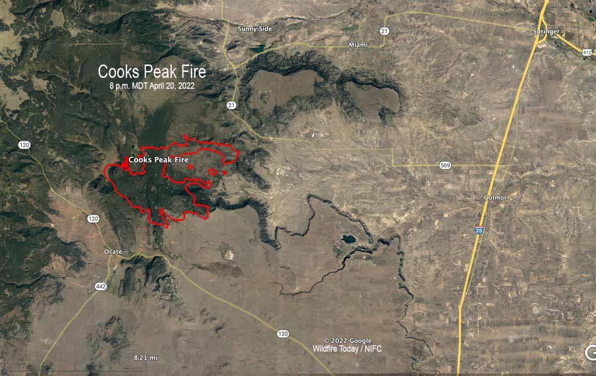
3-D Map of the Cooks Peak Fire, 8 p.m. MDT April 20, 2022.
The Cooks Peak Fire in Northeast New Mexico 16 miles south of Cimarron has been very active Thursday afternoon, with reports of pyrocumulus clouds topping the large smoke plume blowing off to the east-northeast.
The blaze was reported at 4:15 p.m on April 17, 2022. Several ranches are under evacuation orders. The Type 3 Incident Management Team said on Thursday that the fire has burned 21,200 acres.
Cooks Peak Fire. Satellite photo at 3:46 p.m. MDT April 21, 2022.
Resources assigned include 6 hand crews, 11 fire engines, and no helicopters for a total of 198 personnel.
There are no reports of structures burning.
Based on reports of the fire activity on Thursday and the satellite photo of the large smoke plume, the perimeter is most likely significantly different from the one below, mapped Wednesday evening. It likely spread further to the east-northeast.
Map of the Cooks Peak Fire, 8 p.m. MDT April 20, 2022.
Almost all of New Mexico is under a Red Flag Warning Thursday, with a prediction for 20 to 25 mph winds gusting out of the southwest to 60 mph, with 5 to 10 percent relative humidity. The forecast for Friday calls for stronger winds, from the southwest at 40 mph gusting to 57 mph. It will also be very windy on Saturday.