Wildfires may seem unpredictable, leaving random ruin in their wake. But it is based on science.
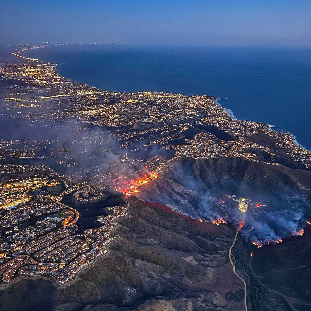
Coastal Fire, Orange County, CA, May 11, 2022. ABC7.
Six months ago we wrote about a project by the First Street Foundation which claimed to have developed a system for calculating the wildfire risk of 145 million properties in the United States.
We tested the system by entering property addresses for homes at two locations that were severely impacted by recent wildfires.
The Marshall Fire near Boulder, Colorado last year destroyed 1,091 homes and damaged 179. We looked up the Risk Factor for three properties in a community that had total destruction. The result was that they all had a 3 of 10 “moderate fire factor”, and individually a 1.84, 2.0, 1.84 percent chance of being in a wildfire over the next 30 years.
The Coastal Fire(see photo above) destroyed 20 homes in Laguna Niguel, California and damaged 11. The two we looked at in the zone with severe destruction received a 3 of 10 “moderate fire factor” with a 0.93 and 1.54 percent chance of being in a wildfire over the next 30 years. The homes were at the top of a steep brush-covered slope.
Another system
Colorado State University engineers have developed a model that they say can predict how wildfire will impact a community down to which buildings will burn. They say predicting damage to the built environment is essential to developing fire mitigation strategies and steps for recovery.
For years, Hussam Mahmoud, a Civil and Environmental Engineering professor, and postdoctoral fellow Akshat Chulahwat have been working on a model to measure the vulnerability of communities to wildfire. Most wildfire mitigation studies have focused on modeling fire behavior in the wildland; Mahmoud and Chulahwat’s model was the first to predict how a fire would progress through a community.
“We’re able to predict the most probable path the fire will take and how vulnerable each home is relative to the neighboring homes,” Mahmoud said. “We put a spin on the original model that allows us now to determine the level of damage in each building, whether the building will burn or survive.”
Using data from Technosylva, a wildfire science and technology company, Mahmoud and Chulahwat tested their model on the 2018 Camp Fire and 2020 Glass Fire in California. The model predicted which buildings burned and which survived with 58-64% accuracy. Since publishing their results in Scientific Reports, they have predicted which buildings burned with 86% accuracy for the Camp Fire by adjusting how the model weighs certain factors that contribute to damage.
Mahmoud says a holistic approach is needed to understand wildfire behavior and bolster resilience. Models that incorporate a community’s wildland and built environment features will give decision-makers the information needed to mitigate vulnerable areas.
Wildfire is like a disease
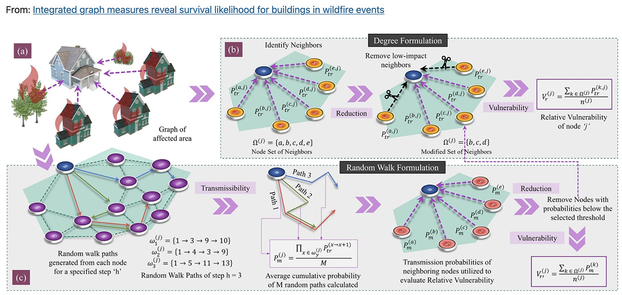
To develop their model, Mahmoud and Chulahwat employed graph theory, which is used to analyze networks. These methods also are used to study how diseases spread.
“Wildfire propagation in communities is similar to disease transmission in a social network,” Mahmoud said. Fire spreads from object to object in the same way contagions pass from one person to another.
Proposed relative vulnerability framework based on Degree ??? and Random walk ???? concepts implemented on (a) formulated graphs of the selected testbeds. (b) The modified degree formulation involves the following steps—(1) neighboring nodes identification, (2) Removal of low-impact connections from neighbors, and (3) Relative Vulnerability calculation. (c) The modified random walk formulation includes—(1) Generation of random walks of specific step length for each node, (2) Transmissibility calculation based on random walks generated, (3) neighboring nodes identification, (4) Removal of low transmissibility neighbors, and (5) Relative vulnerability calculation.
Wildfire mitigation strategies are like the tactics used to control the spread of COVID-19, he said. A community’s immune system can be boosted by mapping a structure’s surroundings (contact tracing), clearing defensible space around structures (social distancing), reinforcing structures to be more fire resistant (immunization), and creating a buffer zone at the wildland-urban interface (closing borders).
Some homes are like super-spreaders — they are more at risk of fire and more likely to transmit fire to other homes. By targeting certain homes or areas for reinforcement, policymakers could maximize a community’s mitigation efforts, Mahmoud said.
As wildfire risk is compounded by more people moving to wildland-adjacent areas and climate change drying out the landscape in arid regions, the researchers hope their model will help protect communities from the devastating losses wrought by wildfires.
“Fire science is not rocket science—it’s way more complicated.”
Robert Essenhigh, Professor Emeritus, Mechanical and Aerospace Engineering, Ohio State University.
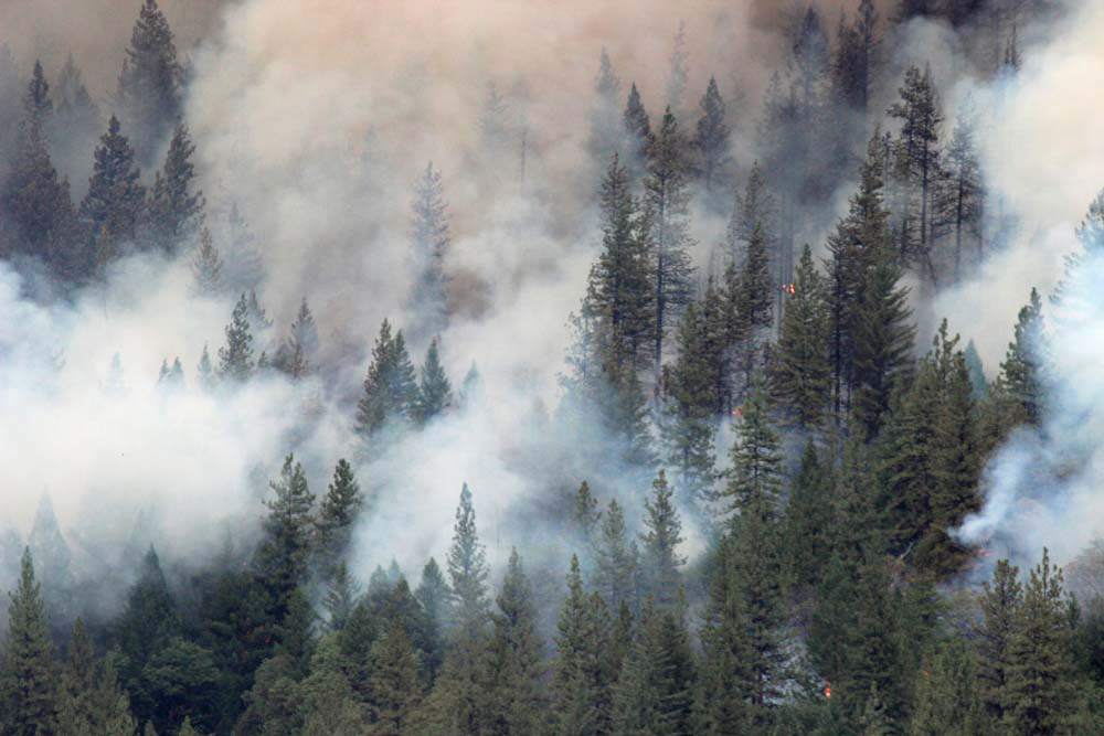
Smoke at the Beaver Fire in Northern California, August 12, 2014. Photo by Bill Gabbert.
Immune cells that normally protect against inflammation and infections can be altered by wildfire smoke to promote inflammation. A long list of diseases are associated with inflammation. Studies have shown that healthy individuals and those with pre-existing conditions are affected by the very small PM2.5 particles produced by wildfire smoke.
Forecast for the distribution of smoke at 4 a.m. PDT October 26, 2019 in the San Francisco area and south as far as Santa Maria.
Below are excerpts from an article written by Tori Rodriguez first published in Pulmonology Advisor. It covers the effects of smoke on humans and suggests what could be done to mitigate the potential damage. One idea is for fire and local officials when considering evacuation guidelines to plan for not only the dangers of flames, but also the effects of smoke.
[With wildfires increasing] and the health issues that result, there is a real and growing need for clinicians to educate at-risk patients, according to Jennifer Stowell, PhD, a postdoctoral researcher in the department of environmental health at the Boston University School of Public Health and co-author of a recent study on the health effects of wildfires.2 “For clinicians, education of patients is paramount, especially for those with already compromised health,” said Dr Stowell.
Healthy individuals may also experience health consequences from wildfires, according to Angela Haczku, MD, PhD, professor of medicine at the University of California, Davis, School of Medicine and director of the UC Davis Lung Center. “During the 2020 California wildfire season, my team conducted a study on healthy individuals and found alarmingly increased numbers of abnormal, activated immune cells in the peripheral blood.3 These cells are normally responsible for protecting against inflammation and infections, but when altered by inhalation of wildfire smoke, they become the ones promoting inflammation,” she explained.
Research exposes burning issues
The vast majority of recent US wildfires have been concentrated in western states, including Washington (218 fires), California (153 fires), Montana (141 fires), and Utah (130 fires).1 Estimates show that more than 70,000 wildfires have burned an average of 7 million acres in the US annually since the year 2000.4
In addition to this geographic damage, a sizeable body of research has detailed the negative human health effects resulting from exposure to wildfire smoke:
In a study published in June 2022, Heaney et al found that “smoke event” days — those with the highest amounts of particulate matter 2.5 (PM2.5) from wildfires — were linked to increases in unscheduled hospital visits in California for all respiratory diseases (3.3%; 95% CI, 0.4%-6.3%) as well as asthma specifically (10.3%; 95% CI, 2.3%-19.0%), with the largest effect observed among children ages 0 to 5 years with asthma.2
Stratified analyses demonstrated increased visits for all cardiovascular diseases, ischemic heart disease, and heart failure among non‐Hispanic White patients and individuals older than 65 years. The findings further suggested that the interaction between wildfire PM2.5 concentrations and high temperatures may further increase the need for hospital visits among patients with cardiovascular disease.
A 2022 scoping review found evidence of increased population-level mortality, respiratory morbidity, and rates of various types of cancer in association with exposure to PM2.5 and chemicals from wildfire smoke.5
Findings from a 2021 study indicate that particulate matter from wildfire smoke has a greater effect on respiratory health than particulate matter from other sources of emission, based on a comparison of the increase in respiratory hospitalizations associated with increases in wildfire-specific PM2.5 (increase in hospitalizations ranging from 1.3% to 10%) and non-wildfire PM2.5 (increase in hospitalizations from 0.67% to 1.3%) in Southern California.6
Research published in 2021 showed that a 10 µg/m3 increase in wildfire PM2.5 was correlated with increased hospitalizations for all respiratory diseases, asthma, chronic obstructive pulmonary disease (COPD), and ischemic heart disease in Colorado. Wildfire PM2.5 was also associated with an increase in deaths due to asthma and myocardial infarction.7
Other results reported in 2021 linked wildfire PM.2.5 exposure in Alaska to elevated odds of asthma-related emergency department (ED) visits among various population, with odds ratios ranging from 1.10 (95% CI, 1.05-1.15) to 1.16 (95% CI, 1.09-1.23).8
A 2018 study analyzed data pertaining to 21,353 inpatient hospitalizations, 25,922 ED presentations, and 297,698 outpatient visits during periods of heightened smoke exposure from the 2007 San Diego wildfires. The results demonstrated a 34% increase in ED visits for respiratory diagnoses and a 112% increase in ED visits for asthma. Even greater increases in ED visits were observed among children aged 0 to 4 years with respiratory diagnoses (73% increase) and in children aged 0 to 1 year with asthma (243% increase).9
Studies have also demonstrated increases in ED visits and hospitalization rates for asthma and other respiratory diseases in relation to wildfire PM2.5 in states such as Oregon and Nevada.10,11
Additionally, findings from multiple studies point to a potential connection between wildfire smoke exposure and higher rates of COVID-19 infection and associated mortality. In 1 study, researchers found that COVID-19 cases and related deaths increased by 56.9% and 148.2%, respectively, after the onset of the California wildfires that began in September 2020 compared with the period of time from the onset of the pandemic to just before the wildfires began.12
Results of another recent study suggest that “wildfire smoke inhalation sequesters activated, pro-inflammatory [natural killer] cells to the affected tissue compartments and may interfere with [COVID-19] vaccine effectiveness,” according to the authors.13
We interviewed Drs Stowell and Haczku to find out more about what clinicians need to know about the health effects of wildfires. Notably, Dr Haczku recently chaired the 2022 third annual NorCal Symposium on Climate, Health, and Equity.
“The size of the particulate matter is important….Particles larger than 10 micrometers in diameter are deposited in the nose, mouth, and upper airways, while PM2.5 is sucked directly down to the alveoli…causing disruption and inflammation.”
Dr Angela Haczku, Director of the University of California Davis Lung Center and chair of the 2022 NorCal Symposium on Climate, Health, and Equity.
What is known about the health effects of exposure to wildfire smoke?
Dr Stowell: Several studies have investigated the health effects of wildfire smoke and have linked smoke exposure to respiratory disease, cardiovascular disease, and birth outcomes such as preterm birth and low birth weight.14 Several gaps remain, including a better understanding of indoor air quality during wildfire events, the risk to outdoor workers, pregnancy complications, and mental health.
Dr Haczku: Wildfire smoke contains particulate matter of varying sizes, usually classified into PM10 and PM2.5 and ozone (O3) and nitrogen-containing toxic gases. All of these are combined with volatile organic chemicals that fuel the flames, the quality and quantity of which depend on whether what is burning comes from wild land, urban areas, or combined areas.
The size of the particulate matter is important because it determines where in the respiratory tract it will end. Particles larger than 10 micrometers in diameter (PM10) are deposited in the nose, mouth, and upper airways, while PM2.5 is sucked directly down to the alveoli, the tiny sacs responsible for our breathing, causing disruption and inflammation.
These particles are also carriers of inflammatory, allergenic, infectious, and toxic molecules causing both acute and chronic illnesses.
The most affected and best-studied organs susceptible to wildfire smoke are the respiratory tract and the cardiovascular system. Most ED visits are related to exacerbations of asthma and COPD and heart conditions such as coronary disease. Respiratory and cardiovascular mortality and hospitalization rates are well-known to be increased during wildfires. Affected adults and children also often suffer from anxiety and other mental health conditions. These conditions and the long-term health effects of wildfires are less studied and poorly understood.
What are the implications of these effects for health care systems?
Dr Stowell: Increasing wildfire activity due to climate change will continue to exacerbate these issues. Wildfire smoke exposure used to be thought of as an issue for the western US. However, as seen in the past several years, smoke from large fires and complex fires can reach across the continental US, exposing many individuals to harmful pollutants. Even with this wider spread of smoke, exposure will continue to have the greatest effect on the health of communities close in proximity to the fires, where smoke density is the heaviest.
Often the communities most affected are rural and face distance barriers to accessing proper health care. Thus, the health care systems in these already underserved areas could face capacity and response issues as wildfire smoke exposure continues to increase in western US states.
Dr Haczku: The effect of wildfire smoke on respiratory, cardiovascular, mental, and general health could be alleviated through specific interventions. As such, wildfire-related disasters provide health care systems with an opportunity to take a proactive role. Health care professionals should strategically and intentionally prepare for wildfire smoke events. Educational material should be prepared using professional society-approved guidelines and toolkits. These also need to be translated into the languages of and distributed to patients and potentially affected communities as well as the general public.
Having an efficient local system in place for timely warnings to reduce time spent outdoors during wildfire smoke events is crucial. Preventive measures in schools and indoor public places such as improved air filtration systems should be installed.
What are recommendations or considerations for clinicians to keep in mind when caring for patients in areas most affected by wildfires?
Dr Stowell: Education of patients is paramount. Some other steps could include considering temporary staff increases during wildfire seasons, ensuring the clinic staff are well-educated regarding wildfire smoke safety measures, and partnering with communities to provide clean air options for their patients.
Dr Haczku: In addition to intensive management of risk factors and chronic diseases, I believe implementing preventive measures are the most important. For example, professionals need to make sure that timely public warnings of smoke events are in place. Clinicians and health care workers should have a database that can be used to identify and reach out to vulnerable populations including pregnant women, children, the elderly, and farm and construction workers. Education of these communities and individuals can prevent emergency situations. Susceptible patients suffering from chronic illnesses and workers who cannot avoid outdoor activities may require help with fitting personal respirators and devices and specific consultation by health care workers.
What broader measures are needed to buffer the effects of wildfire smoke exposure and protect vulnerable populations, such as those with respiratory and cardiovascular diseases?
Dr Stowell: Much more needs to be done to plan for these large fire events. This planning includes focusing efforts in the areas most often affected by smoke through increasing health care system capacity, forming mobile health response teams, proper community education, better guidelines for evacuation (as most evacuations are intended to avoid the flames and not the smoke). Another need is access to clean air options, such as providing clean air centers and affordable access to air purification technology, including air conditioning and HEPA filtration.
Dr Haczku: As a health care educator, administrator, and climate change researcher, I see an urgent unmet need for the education of health care professionals about the effects of wildfires and, more generally, of climate change on human health. Vulnerable subjects, especially patients suffering from chronic health conditions, should be identified and educated. Improving advocacy toolkits and updating evidence-based professional guidelines for disease management and preventive interventions to reduce risk and protect health is imperative.
Research efforts to study and better understand wildfire smoke-induced pathologies as well as research to investigate the effectiveness of novel interventions should be better supported.
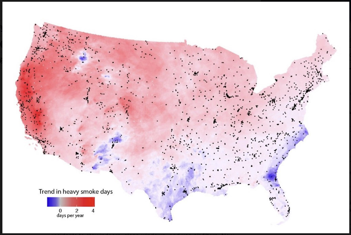
Measurements from satellites indicate rapidly growing exposure to heavy smoke plumes across much of the U.S. Map shows the estimated annual increase between 2011 and 2020 in the number of smoke plumes that NOAA analysts designate as “heavy,” their densest plume classification. Dots indicate EPA ground-based pollution monitors. Credit: Burke et al.
By Josie Garthwaite, Stanford University
When drifting wildfire smoke brings hazardous air pollution to cities and towns across the country, public health officials urge residents to stay indoors, close windows, and use air filters. New research from Stanford University shows Americans are getting the message, yet still rarely succeed at keeping smoke from entering their homes.
Researchers led by Marshall Burke, an associate professor of Earth system science, analyzed data from consumer-grade air pollution sensors in 1,520 single-family homes across the U.S., as well as nearby outdoor air pollution monitors, cell phones, social media posts, and Google searches in English and Spanish between 2016 and 2020.
They found internet searches for air quality information increased on heavy smoke days, regardless of income, while searches for air filters, smoke masks, and other protective measures recommended by health officials rose only in wealthy neighborhoods. Residents of wealthier neighborhoods are also more likely to shelter at home when wildfire smoke pollutes outside air. “People seem to know they’re being exposed. We see a lot of behaviors change even at pretty low levels of smoke exposure, although those responses differ by socioeconomic status,” said Burke.
The results, published July 7 in Nature Human Behaviour, show that better education and information about health hazards from wildfire smoke are not enough to protect people from the health harms of wildfire smoke exposure. The findings also bolster evidence for nascent efforts to take a more proactive and systematic approach to mitigating public health risks from wildfire smoke, predicted to be one of the most widely felt health impacts of climate change nationwide.
While most current government policies rely on a do-it-yourself approach to avoiding unhealthy air from wildfires, this tactic will have “modest and unequal benefits,” the authors write. Short-term solutions include establishing clean air shelters and providing public subsidies for lower-income households to filter indoor air. “If people can’t maintain good air quality in their homes, they need a place to go where they can breathe clean air,” said Burke, who is also deputy director of Stanford’s Center on Food Security and the Environment. “That’s a great place to start.”
Leaky homes
Overall, the authors found indoor concentrations of the deadliest type of particle pollution, known as PM 2.5, often remain three to four times higher than public health guidelines, and can vary by a factor of 20 between neighboring households during heavy smoke days. “Households that look exactly the same in terms of income, house price, and house size had enormously different indoor air for a given level of outdoor air quality,” said study co-author Sam Heft-Neal, a researcher at the Center on Food Security and the Environment. According to the authors, the most likely culprits are open doors and windows, leaky buildings, and a lack of filtration.
As the number of heavy smoke days in California and the West continue to climb, lawmakers from several western states have introduced bills that would allow the president to declare a “smoke emergency,” provide federal funding to establish clean air shelters and relocate vulnerable populations, and create a grant program for local community planning related to wildfire smoke. None have been enacted.
“To be able to intervene appropriately, we have to be able to measure things, including what people are exposed to in their home and how they’re behaving,” said Burke. That ability is rapidly expanding, thanks to the growing number of people buying relatively low-cost but reliable air quality monitors from PurpleAir, a private company, and agreeing to have the data put on a public website—although households who own the monitors, for now, are overwhelmingly Californian and higher income. “Our ability to precisely measure infiltration at the household level and then relate that to things we observe about the house or the community is new,” Burke said.
In the absence of systematic support at the federal level, a patchwork of local and state mitigation efforts has emerged. Oregon’s environmental agency, for example, has provided a grant for the city of Ashland to set up a free air purifier distribution program for vulnerable residents. In California, where more than half the population experienced a month of wildfire smoke levels in the range of unhealthy to hazardous during the 2020 fire season, the state has launched a $5 million pilot program providing grants for smoke shelters.
Still, most places are no better prepared for unhealthy air this year than they were in 2020 and, as large fires become more frequent, it will become increasingly onerous for people to protect themselves. “We’ve dug ourselves a huge hole in terms of the amount of accumulated dry fuel in our forests. It’s going to require unprecedented levels of investment over a sustained period to reduce fire risk and lower smoke exposures for everyone,” Heft-Neal said. “In the meantime, we have to be prepared for the large wildfires that, unfortunately, we’re going to get. And we have to be ready to deal with the downwind exposures that those wildfires generate.”
The US Forest Service is partnering with NASA to evaluate the use of two high-altitude long endurance drones to improve wildland firefighters’ situational awareness.
1. A balloon
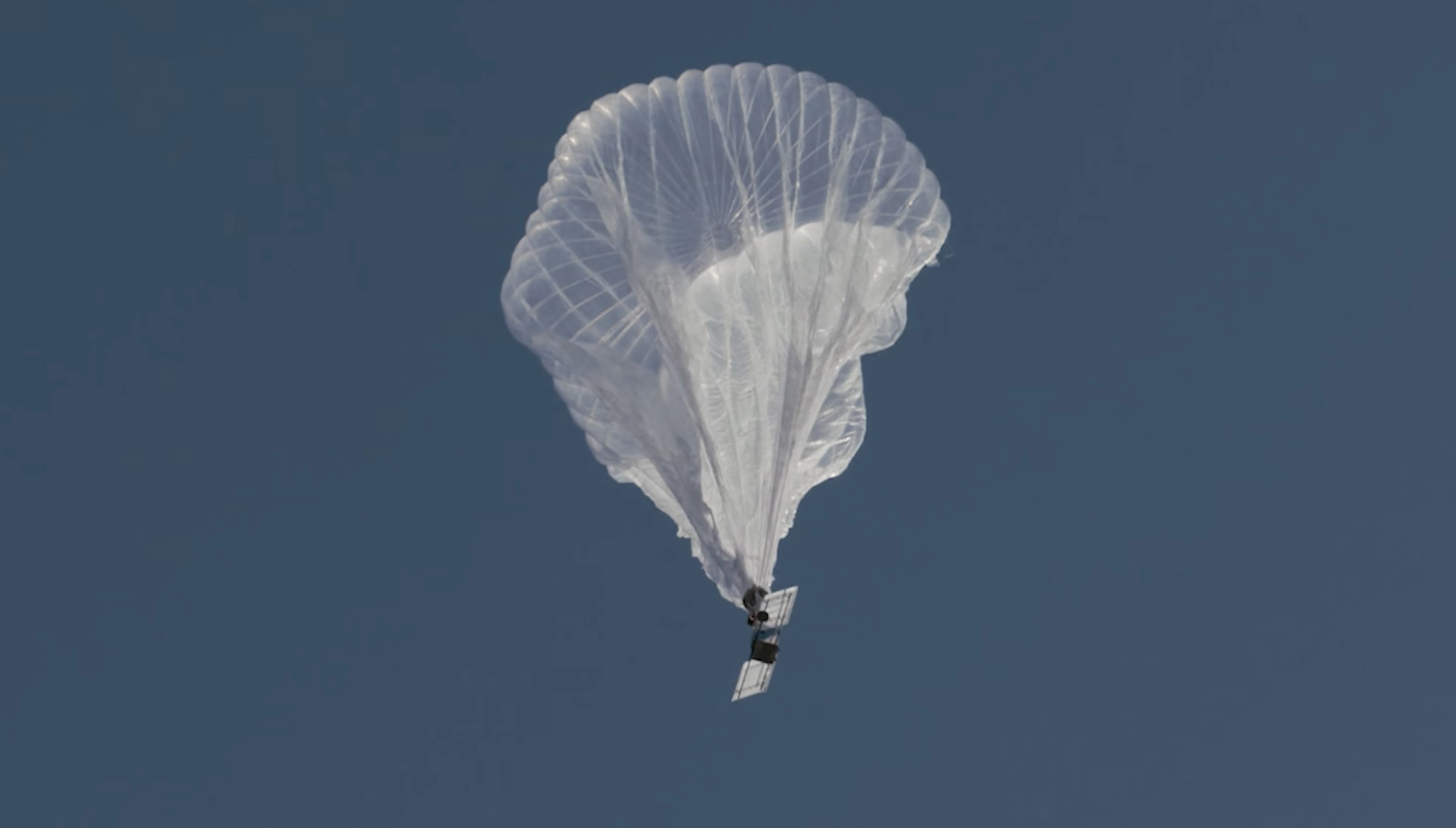
Last week a balloon laden with a sophisticated package of electronics hovered 60,000 feet over the Moose Fire in Idaho. Its mission was to assist firefighters in improving and maintaining situational awareness. Some of them may have seen the shiny object the size of a football stadium, even though it was more than 11 miles above the incident.
The company that built and operates the aircraft, Aerostar, calls it STRATO, or Strategic Radio and Tactical Overwatch, a technology that is in the research and development phase.
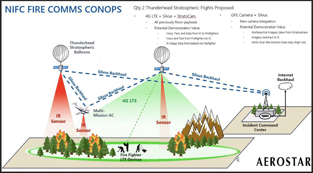
Illustration of how a Thunderhead Stratospheric balloon can assist wildland firefighters.
The STRATO is basically a giant mylar balloon with solar panels, batteries, radio equipment, cameras, and sensors. It has the capability to collect infrared and visual data, broadcast an LTE (cell phone) signal, has a high-band radio that can enable push to talk communications, and can operate a WiFi network. The huge helium balloon can hover over an incident in the stratosphere taking pictures, delivering data to incident managers, and providing communications options to the Incident Command Post and crews on the ground.
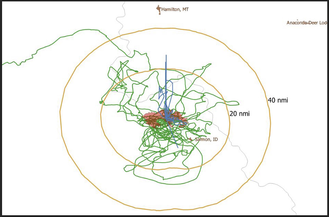
Flight path of an Aerostar Thunderhead Stratospheric balloon over the Moose Fire the week of August 7, 2022.
Last October Fire Aviation wrote about the system operated by Aerostar, a company based near Sioux Falls, South Dakota, which has been working with lighter than air technologies since 1956. We contacted the Communications Manager for the company, Lisa McElrath, who told us that in June, July, and August of 2021 they launched one of their Thunderhead Balloons from South Dakota and flew it west to monitor wildfires. While traveling more than 16,000 miles during its 70-day flight it engaged in station-seeking above four active fires for the company’s research and development. It collected visible and thermal imagery data for extended periods of time on the Robertson Draw Fire (Montana), the Dixie Fire (California), the Dixie-Jumbo Fire (Idaho), and the Dry Gulch/Lick Creek Fire (Washington).
In October we asked Ms. McElrath if Aerostar had been cooperating with the federal land management agencies in mapping fires. She said not yet, but that representatives from the National Interagency Fire Center had reached out to them and expressed interest in discussions after the fire season slowed down. But this year the US Forest Service is officially cooperating in the pilot project.
“We can provide real-time imagery from the balloon today in the visible and infrared,” Ms. McElrath said. “In the future, the goal would be to automate the detection and download of critical imagery, fire perimeters, likely fire-starts, and other key information via onboard processing so that more actionable information would be available. We see stratospheric balloon technology being the key to cost-effective, scalable wildfire surveillance that reduces time between new fire detection and response. Effectively, balloons can alert firefighters to a new fire while it is still small, before the fire grows into something newsworthy and very expensive.”
She said the balloons can also serve as radio repeaters for personnel on the ground and could collect information from tracking devices on firefighting resources which could then be displayed on a map.
More flights over fires are being planned, said Sean Triplett, Team Lead for Tools and Technology, U.S. Forest Service, Fire and Aviation Management. He said NASA is matching the funding the Forest Service is putting toward the flights this year.
2. Fixed wing aircraft
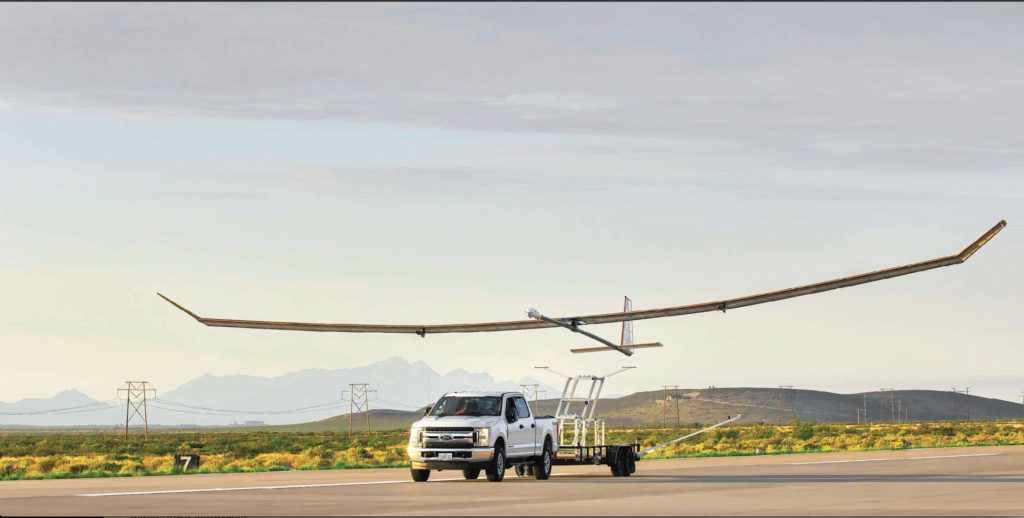
Swift Engineering’s SULE HALE-UAS. Swift Engineering photo.
Another High Altitude Long Endurance (HALE) aircraft the Forest Service is looking at is Swift Engineering’s SULE HALE-UAS, capable of staying aloft for more than 30 days at a time. The Forest Service, again partnering with NASA, has issued a contract with the company and as of March 31, 2021 they had conducted more than 10 demonstrations of the solar powered fixed wing aircraft.
The key to long duration flight using solar power on an airplane is to have a top surface area large enough for the solar cells needed to power the electric motors day and night, using a battery for night operations. Large wings mean more solar cells, but also more wind resistance. So the answer, using today’s technology, is to fly very high at 60,000 to 70,000 feet where the air is thin, the sunlight on the solar panels is strong, and there is less wind resistance.
The SULE, which took its first flight in July of 2020 has a 72-foot wingspan, operates at 70,000 feet, and can carry a payload of 15 to 22 pounds.
“A series of mid-altitude and high-altitude flights is being undertaken, Mr. Triplett told Fire Aviation on Wednesday. “At this point, the platform is only providing remote sensing products. However, if successful, additional systems may be incorporated.” Those added systems could include a radio system to provide connectivity enabling the tracking of firefighting resources on the ground in addition to live imagery of the fire.
Mr. Triplett said one advantage of having NASA as part of the project is that they can handle the airworthiness of the aircraft and interactions with the FAA.
The Swift Engineering video below shows what may be the first flight of the SULE two years ago.
A step toward the Holy Grail of Wildland Firefighter Safety?
Our view is that providing to wildland fire supervisors the real time location of both the fire and firefighting resources is the Holy Grail of Wildland Firefighting Safety. Lacking this information has led to at least two dozen firefighter fatalities. These High Altitude Long Endurance aircraft 13 miles above the fire could be an important link to transmit live video of the fire to personnel and provide radio connectivity enabling the tracking of firefighting resources on the ground even when they are in steep rugged topography. Of course the resources would need to have the hardware necessary to transmit the coordinates of their locations.
The John D. Dingell, Jr. Conservation, Management, and Recreation Act which became law March 12, 2019 required that by March 12, 2021 the five federal land management agencies “…develop consistent protocols and plans for the use on wildland fires of unmanned aircraft system technologies, including for the development of real-time maps of the location of wildland fires.”
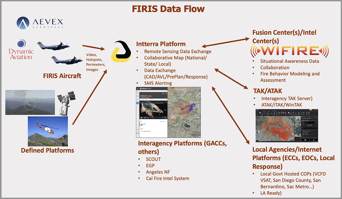
While this technology has been demonstrated, real time mapping appears to be far from being used routinely, at least within the Federal agencies. But at the state level, the Governor of California has requested $30 million in their next budget for 31 positions and funds for the state’s Office of Emergency Services to operate Real-Time Intelligence System (FIRIS) aircraft that have shown that they can provide real time fire mapping information. A pilot program for FIRIS first got off the ground September 1, 2019 thanks to funding secured in the 2019-2020 California state budget. This year two FIRIS ships have been assisting firefighters.
The Dingell Act also mandated that the five federal land management agencies “jointly develop and operate a tracking system to remotely locate the positions of fire resources for use by wildland firefighters, including, at a minimum, any fire resources assigned to Federal type 1 wildland fire incident management teams”, again, due by March 12, 2021.
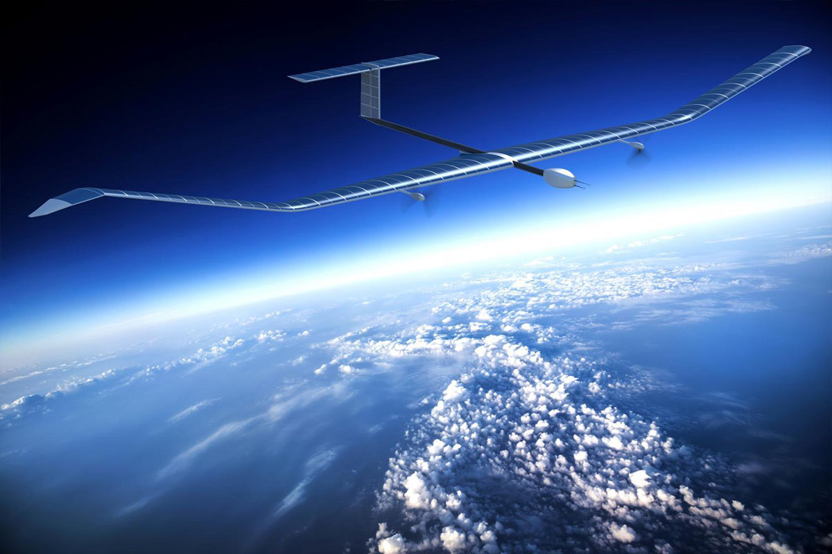
Other solar powered high-altitude aircraft
An aircraft that the Forest Service is not involved with is the Zephyr, made by AIRBUS. It is an unmanned, solar-powered fixed wing aircraft designed to stay aloft at high altitude for months.
AIRBUS Zephyr, stratospheric unmanned aerial vehicle. Airbus image.
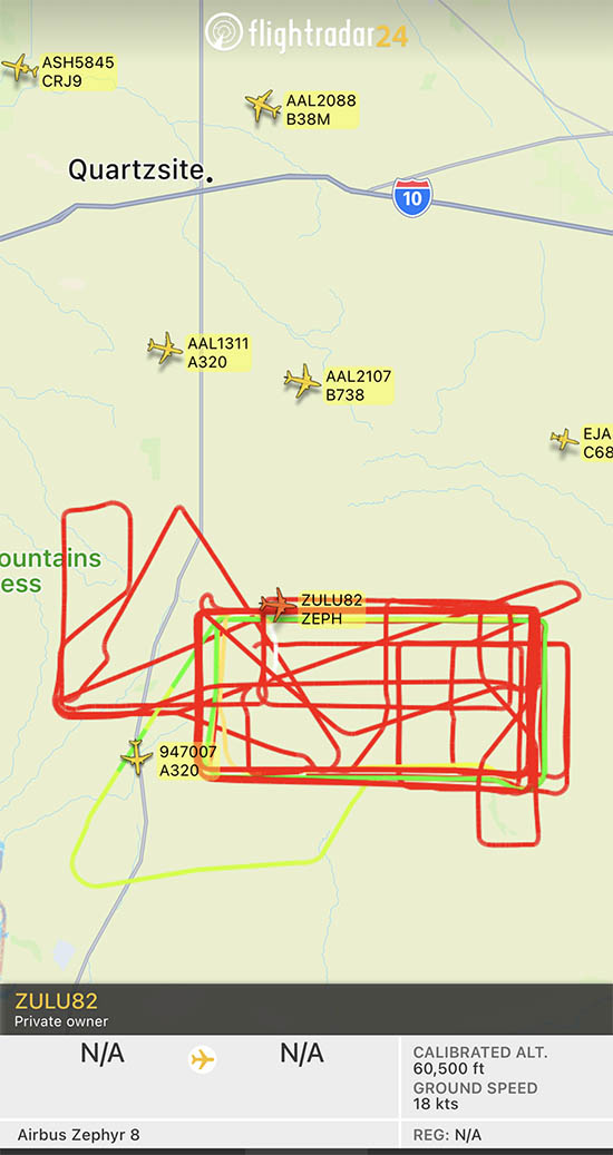
In its latest test flight that began June 15, 2022 the Zephyr took off from the U.S. Army’s Yuma, Arizona Proving Ground and has been flying patterns over the Yuma Test Range and Kofa National Wildlife Refuge ever since. Now 63 days later the flight has smashed Zephyr’s previous record of 25 days that it set in August 2018. When we checked August 17 it was cruising at 40 knots ground speed 70,500 feet above the Earth.
Flight path of ZULU82 Zephyr, a solar-powered unmanned aircraft on August 16, 2022, day 62 of a flight that began June 15, 2022.
UPDATE at 7:35 p.m. MDT August 21, 2022
The flight of the Zephyr has ended.
“Following 64 days of stratospheric flight and the completion of numerous mission objectives, Zephyr experienced circumstances that ended its current flight. No personal injury occurred,” AIRBUS said in a statement.
Simple Flying reported that a catastrophic loss of altitude occured on August 19 after flying for 64 days straight:
On its final day of operations, it was tracking around over the vast Arizona Desert, about halfway between Phoenix and Mexicali, Baja California. Flying slightly lower than was typical, at some 45,000 – 50,000 feet, it had completed an S-shape maneuver at around 50 – 60 knots when something went catastrophically wrong. ADSB data shows a vertical descent rate which rapidly increased, topping out at a speed of 4,544 feet per minute. Although unconfirmed by Airbus, it does seem that the Zephyr met a rather unglamorous end.
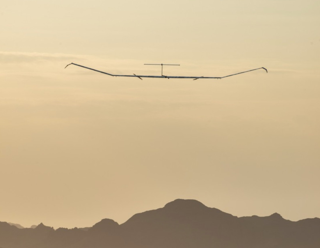
The Airbus Zephyr S during a 2021 test flight. US Army photo.
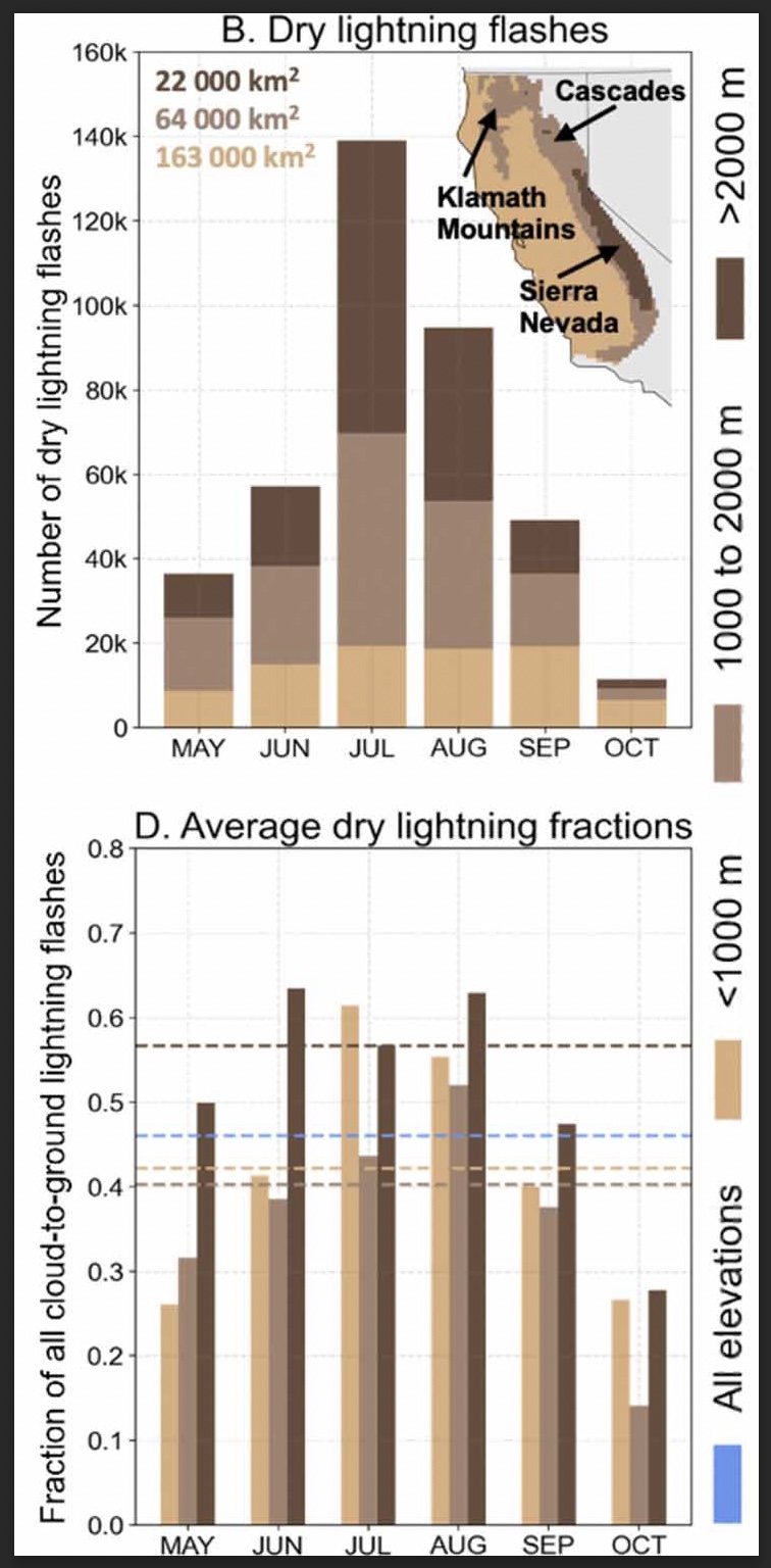
Researchers studied the climatology of dry lightning in California
(B) Total number of dry lightning flashes across three elevation zones (<1000 m, 1000–2000 m, >2000 m) within the domain for each month between 1987–2020. Text indicates the area of each elevation zone, and inset map shows the geographic distribution of the elevation zones and major mountain ranges. (D) The three elevation zones for each month (bars). Dashed lines in (D) indicate the dry lightning fraction averaged across all months for each zone. Blue dashes in (D) represent the dry lightning fraction computed from all months and elevation zones. (From the paper)
A group of six researchers who studied the occurrence and characteristics of cloud to ground lightning in Central and Northern California found that nearly half, 46 percent, was dry, accompanied by less than 0.1 inch of precipitation.
Of course dry lightning is the bane of land managers and is much more likely to ignite a wildfire than a wet thunderstorm. And on the occasions when there are thousands of down strikes, it can overwhelm the capacity to suppress what can be hundreds of fires.
The six scientists used daily gridded lightning and precipitation observations (1987–2020) in combination with atmospheric reanalyses, to characterize the climatology of dry lightning and the associated meteorological conditions during the warm season (May–October) when wildfire risk is highest.
The paper the group produced is available as open source: “Meteorological and geographical factors associated with dry lightning in central and northern California.”
Daniel Swain, a prolific user of Twitter, used the platform today to highlight some of the group’s findings. In the tweet below, click on “read reply” to see more discussion and illustrations.
We assess regional-scale atmospheric conditions favorable for dry lightning in central & northern California (N&C CA), as well as seasonality. We find that nearly half of all lightning strikes in N&C CA are “dry” (accompanied by <0.10 in. of rain). (2/n) https://t.co/DkooDBG0ggpic.twitter.com/1eZpRIG9cX
The six researchers who participated in the project were Dmitri A. Kalashnikov, John T. Abatzoglou, Nicholas J. Nauslar, Daniel L. Swain, Danielle Touma, and Deepti Singh.
Larger plumes send more smoke higher into the atmosphere where it can spread farther
Pyrocumulonimbus cloud over the Bootleg Fire in Oregon, July 14, 2021. InciWeb.
By Paul Gabrielsen Science writer, University of Utah
In recent years, the plumes of smoke crawling upward from Western wildfires have trended taller, with more smoke and aerosols lofted up where they can spread farther and impact air quality over a wider area. The likely cause is climate change, with decreased precipitation and increased aridity in the Western U.S. that intensifies wildfire activity.
“Should these trends persist into the future,” says Kai Wilmot, a postdoctoral researcher in the Department of Atmospheric Sciences at the University of Utah, “it would suggest that enhanced Western U.S. wildfire activity will likely correspond to increasingly frequent degradation of air quality at local to continental scales.”
The study is published in Scientific Reports and supported by the iNterdisciplinary EXchange for Utah Science, or NEXUS, at the University of Utah.
Smoke height
To assess trends in smoke plume height, Wilmot and University of Utah colleagues Derek Mallia, Gannet Haller and John Lin modeled plume activity for around 4.6 million smoke plumes within the Western U.S. and Canada between 2003 and 2020. Dividing the plume data according to EPA ecoregions (areas where ecosystems are similar, like the Great Basin, Colorado Plateau, and Wasatch and Uinta Mountains in Utah) the researchers looked for trends in the maximum smoke plume height measured during August and September in each region in each year.
In the Sierra Nevada ecoregion of California, the team found that the maximum plume height increased, on average, by 750 ft (230 m) per year. In four regions, maximum plume heights increased by an average of 320 ft (100 m) per year.
Why? Wilmot says that plume heights are a complex interaction between atmospheric conditions, fire size and the heat released by the fire.
“Given climate-driven trends towards increasing atmospheric aridity, declining snowpack, hotter temperatures, etc., we’re seeing larger and more intense wildfires throughout the Western U.S.,” he says. “And so this is giving us larger burn areas and more intense fires.”
The researchers also employed a smoke plume simulation model to estimate the mass of the plumes and approximate the trends in the amount of aerosols being thrown into the atmosphere by wildfires . . . which are also increasing.
The smoke simulation model also estimated the occurrence of pyrocumulonimbus clouds—a phenomenon where smoke plumes start creating thunderstorms and their own weather systems. Between 2017 and 2020, six ecoregions experienced their first known pyrocumulonimbus clouds and the trend suggests increasingly frequent pyrocumulonimbus activity on the Colorado Plateau.
Taller plumes send more smoke up into higher elevations where it can spread farther, says John Lin, professor of atmospheric sciences.
“When smoke is lofted to higher altitudes, it has the potential to be transported over longer distances, degrading air quality over a wider region,” he says. “So wildfire smoke can go from a more localized issue to a regional to even continental problem.”
Are the trends accelerating?
Some of the most extreme fire seasons have occurred in recent years. So does that mean that the pace of the worsening fire trend is accelerating? It’s too early to tell, Wilmot says. Additional years of data will be needed to tell if something significant has changed.
“Many of the most extreme data points fall within the years 2017 -2020, with some of the 2020 values absolutely towering over the rest of the time series,” he says. “Further, given what we know of the 2021 fire season, it appears likely that analysis of 2021 data would further support this finding.”
In Utah’s Wasatch and Uinta Mountains ecoregion, trends of plume height and aerosol amounts are rising but the trends are not as strong as those in Colorado or California. Smoke from neighboring states, however, often spills into Utah’s mountain basins.
“In terms of the plume trends themselves, it does not appear that Utah is the epicenter of this issue,” Wilmot says. “However, given our position as generally downwind of California, trends in plume top heights and wildfire emissions in California suggest a growing risk to Utah air quality as a result of wildfire activity in the West.”
Wilmot says that while there are some things that people can do to help the situation, like preventing human-caused wildfires, climate change is a much bigger and stronger force driving the trends of less precipitation, higher aridity and riper fire conditions across the West.
“The reality is that some of these [climate change] impacts are already baked in, even if we cut emissions right now,” Wilmot adds. “It seems like largely we’re along for the ride at the moment.”