Wildfires have burned over 800 square miles in Oregon

Four fires east of Interstate 5, from Portland south to Eugene, are each larger than 100,000 acres.

map fires Oregon Portland
Map showing heat detected by satellites within the last 24 hours on fires in the Portland-Eugene area, Sept 10, 2020.

At least 50 fires have burned over 800 square miles in Oregon, and again on Wednesday, dry, breezy weather kept them growing.  Governor Kate Brown said that during this fire siege the state will likely experience the greatest loss of property and lives from wildfires in its history. This a result of the confluence of several factors, including drought and lightning, along with hot, dry, and very windy weather.

The Oregon Office of Emergency Management has created an interactive website to help provide information about evacuations statewide.

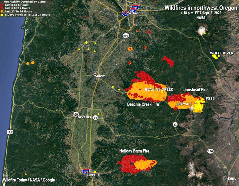
The Beachie Creek Fire 17 miles east of Salem started August 16. On September 6 it was 469 acres but the historic wind storm the next day caused it to grow overnight to 131,000 acres. On September 9 it was mapped at 182,000 acres and was 19 miles east of Salem. Fire personnel had to evacuate their incident command post after electrical lines and transformers were destroyed during the wind event. An update from the incident management team on September 9 said “mass evacuations are being planned”. The east side of the Beachie Creek Fire has merged with the Lionshead Fire. The fire organization has a Facebook page with evacuation information.

The 109,223-acre Lionshead Fire started August 16 on the Confederated Tribes of Warm Springs Reservation 14 miles west of the Warm Springs community and has spread to the Willamette National Forest merging into the east side of the Beachie Creek Fire. It is actively growing on the west side of the Cascades. Long range spotting contributed to the fire spreading for 12 miles reaching areas near Breitenbush and Detroit Lake. The fire also crossed highway 22 in multiple places.  More information can be found on Facebook.

The Holiday Farm Fire, also known as the McKenzie Fire, has burned 144,694 acres about 14 miles east of Eugene. Evacuations are in effect; the Lane County government and  Linn County Sheriff’s office has more information. On Wednesday fire behavior and weather conditions were still treacherous and kept firefighters from accessing many areas, but they were able to protect some structures by burning out around them to remove flammable vegetation. Winds on Thursday are expected to shift and begin blowing out of the west and relative humidity is expected to be in the low teens.  These weather conditions may contribute to another day of very active fire behavior.

The 120,000-acre Riverside Fire is southeast of both Oregon City and Portland. Most of the spread in the last 24 hours was on the southwest and northwest sides. The blaze moved four miles down the Clackamas River corridor towards the communities of Estacada and Springwater. Crews worked overnight to continue point protection efforts on homes and other critical infrastructure in that area and along Highway 211. On Thursday firefighters hope to take advantage of predicted lighter winds during the afternoon to conduct critical air operations. However, changing wind directions throughout the day could spur additional fire growth in multiple directions. Thursday morning fire officials estimated it was approximately two air miles from the community of Estacada, Oregon. The Clackamas County Sheriff’s office has information about evacuations that are in effect.

The Echo Mountain Complex has burned 2,297 acres south and east of Otis at the intersection of Highways 101 and 18. Evacuations are in effect. It is burning on both the north and south sides of 18. The Oregon Department of Forestry reports that local firefighters and ODF personnel have been out in force around the clock on the fire lines, but outside help is very limited due to the large number of fires across the state. Matt Thomas of ODF said Wednesday there has been no containment yet, and that may not happen for an extended period of time. More information is on the ODF’s West Oregon District Facebook Page.

Bobcat Fire spreads east across Highway 39

In the Angeles National Forest above Arcadia and Glendora, southern California

map Bobcat Fire Los Angeles California wildfire
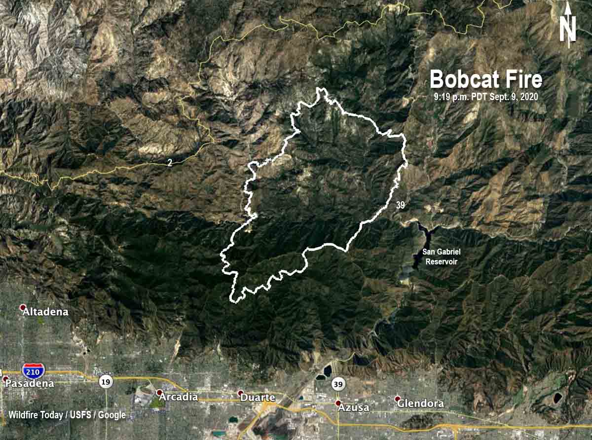
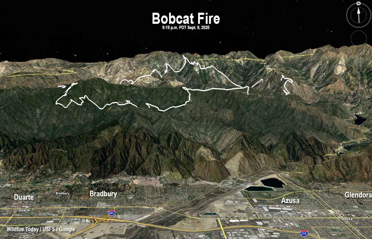
3-D map of the Bobcat Fire at 9:19 p.m. PDT Sept. 9, 2020. Looking north.

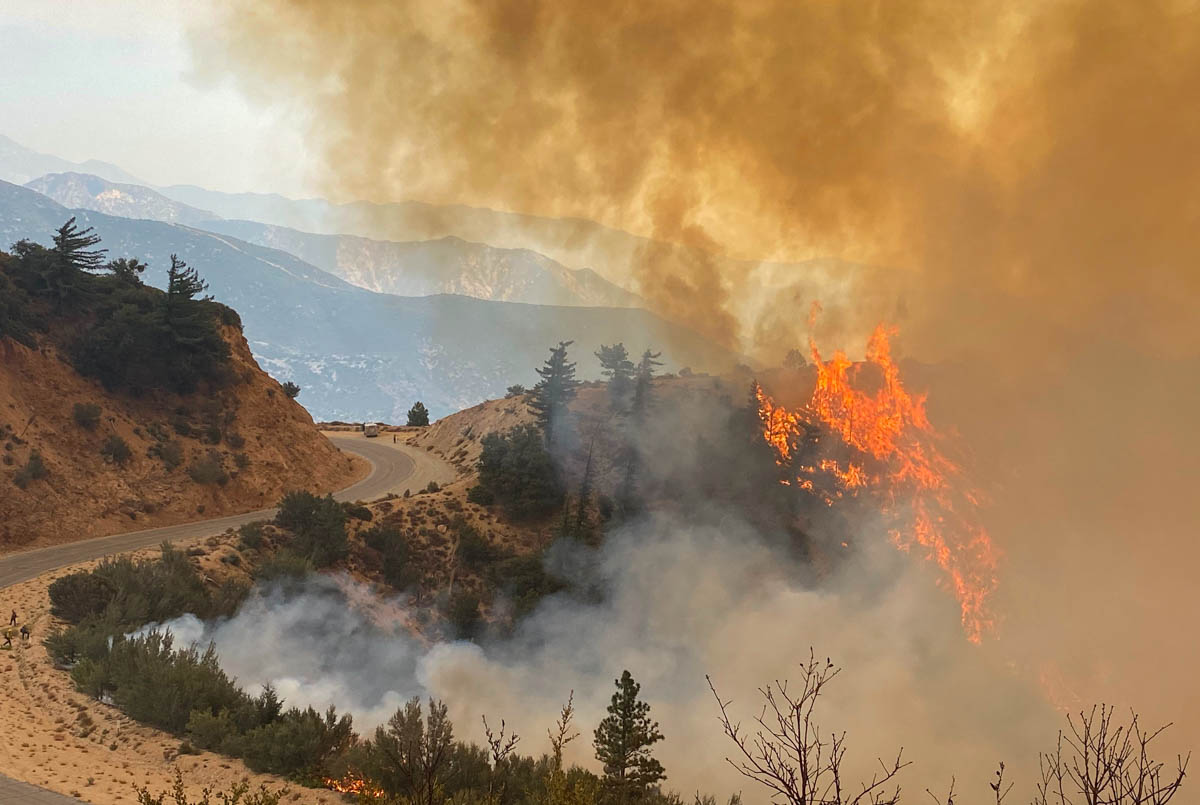
The Bobcat Fire burning in the mountains above Arcadia in southern California grew substantially to the east Wednesday crossing Highway 39 above San Gabriel Reservoir. The latest size estimate from the U.S. Forest Service is 19,796 acres.

Firefighters described the fire behavior as very active to extreme with long-range spotting, tree torching, and visible slope runs. With the fire moving to the east there was an opportunity to work on the southern flank to help protect the foothill communities. The main objective was to prepare and strengthen fire lines constructed by dozers and hand crews. As the day progressed and the dense smoke lifted, two air tankers, including a DC-10, were able to make several drops of fire retardant on the southwest portion of the fire to reinforce and strengthen the fire lines. Later in the day a sky crane helicopter arrived on scene.

firefighters Bobcat Fire Los Angeles California wildfire
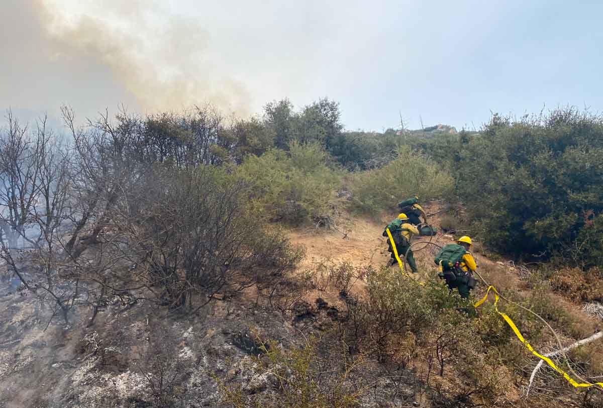
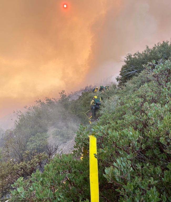
Firefighters put in a hose lay on the Bobcat Fire September 9, 2020. Photo by Rob Robledo.

Local fire departments continued their structure protection planning and triage efforts within the growing list of foothill communities that are under evacuation warnings — Monrovia, Arcadia, Sierra Madre, Bradbury, Altadena, Duarte, and Pasadena.

(To see all articles on Wildfire Today about the Bobcat Fire, including the most recent, click HERE.)

The number of resources assigned to the incident has grown, and now includes 19 hand crews, 35 engines, and 1 helicopter, for a total of 652 personnel.

The fire is being managed by a Type 2 incident management from the eastern United States.

These are low numbers for a 20,000-acre wildfire threatening seven high density communities in the wildland-urban interface of the Los Angeles area.

firefighters Bobcat Fire Los Angeles California wildfire
Bobcat Fire September 9, 2020. Photo by Rob Robledo.

Weather forecasters expect northeast winds to continue Thursday, becoming south or southwest in the afternoon. On the higher elevation ridgetops the wind speeds will be 10 to 15 mph gusting to 20 mph. With the relative humidity in the teens on the upper slopes, it is likely that the fire will be active Thursday.

map Bobcat Fire Los Angeles California wildfire
Map of the Bobcat Fire at 9:19 p.m. PDT Sept. 9, 2020. The fire spread further to the east after this perimeter data was collected.
firefighters Bobcat Fire Los Angeles California wildfire
Firefighters put in a hose lay on the Bobcat Fire September 9, 2020. Photo by Rob Robledo.

North Complex of fires estimated at a quarter of million acres after explosive growth

September 9, 2020 | 4:20 p.m. PDT

Claremont and Bear Fires
North Complex of Fires, 11:36 p.m. PDT Sept. 8, 2020. The Claremont/Bear Fire, two fires that merged.

One of the fires on the North Complex of fires east of Chico, California apparently grew by about 100,000 acres Tuesday. Operations Section Chief Jake Cagle said Wednesday morning that 45 mph winds pushed the Claremont/Bear Fire to the southwest for miles until it reached Lake Oroville east of the city by the same name. But it didn’t stop there. According to the map produced by the incident management team it worked its way around the south side of the lake and may have even spotted across the lake.

With the extremely rapid growth, firefighters were unable to have the luxury of containing the fire’s edge, their time had to be spent on the urgent matters of firefighter and public safety, notifying citizens of mandatory evacuations, and protecting structures.

Evacuation information can be found at the Plumas National Forest’s Facebook page. A virtual community meeting will be available there at 6 p.m. PDT today (Wednesday).

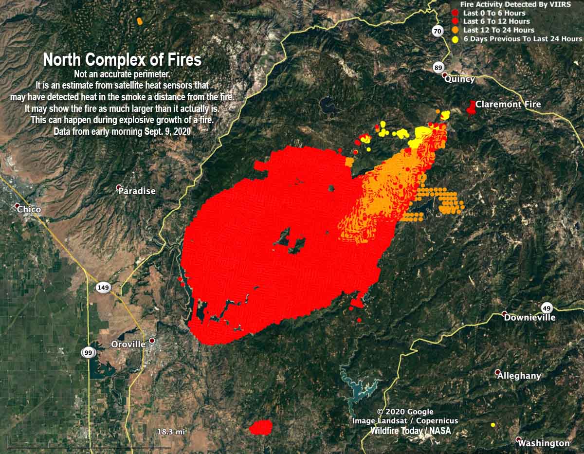
The exact location of the fire’s edge was not certain at mid-day Wednesday because an aircraft scheduled to map the fire Tuesday night became unavailable due to a maintenance issue. Without the more accurate mapping system, the incident management team used heat-sensing data collected by satellites to evaluate the size, which is far less reliable. Mr. Cagle estimated Wednesday morning that the fire at that time was about 45 miles long and 30 miles wide.

The incident management team believes the North Complex of fires has burned approximately 254,000 acres, an increase of about 104,000 acres over the figure released earlier in the day.

The North Complex is comprised of multiple fires, most of which were suppressed, but remaining were the Bear and Claremont blazes. The map below shows where they were on August 20 before they burned together. The team fighting the fire now is referring to it as Bear Fire, or the North Complex.

Claremont and Bear Fires
The Claremont and Bear Fires, August 20, 2020.

The map below is not an accurate perimeter. It is an estimate from satellite heat sensors that may have detected heat in the smoke a distance from the fire, in addition to the fire itself. It may show the fire as being much larger than it actually is. This can happen during explosive growth of a fire that is burning very intensely and putting up a very large column of smoke containing a great deal of ash and debris.

Claremont and Bear Fires
North Complex of Fires. Early morning Sept. 9, 2020. Not an accurate perimeter. It is an estimate from satellite heat sensors that could have detected heat in the smoke a distance from the fire. It may show the fire as much larger than it actually is. This can happen during explosive growth of a fire.

Glendower Fire (aka Almeda Fire) burns toward Medford, Oregon

Multiple structures have burned

Updated September 9, 2020 | 9:04 a.m. PDT

Map Almeda Drive and South Obenchain Fires
Map of the Almeda Drive and South Obenchain Fires at 4:14 a.m. PDT Sept 9, 2020.

A second fire in the Medford, Oregon area, the South Obenchain Fire north of the city, is prompting evacuations in the Shady Cove and Eagle Point areas. Evacuation maps are HERE.


September 9, 2020 | 8:33 a.m. PDT

Map of the Almeda Drive Fire
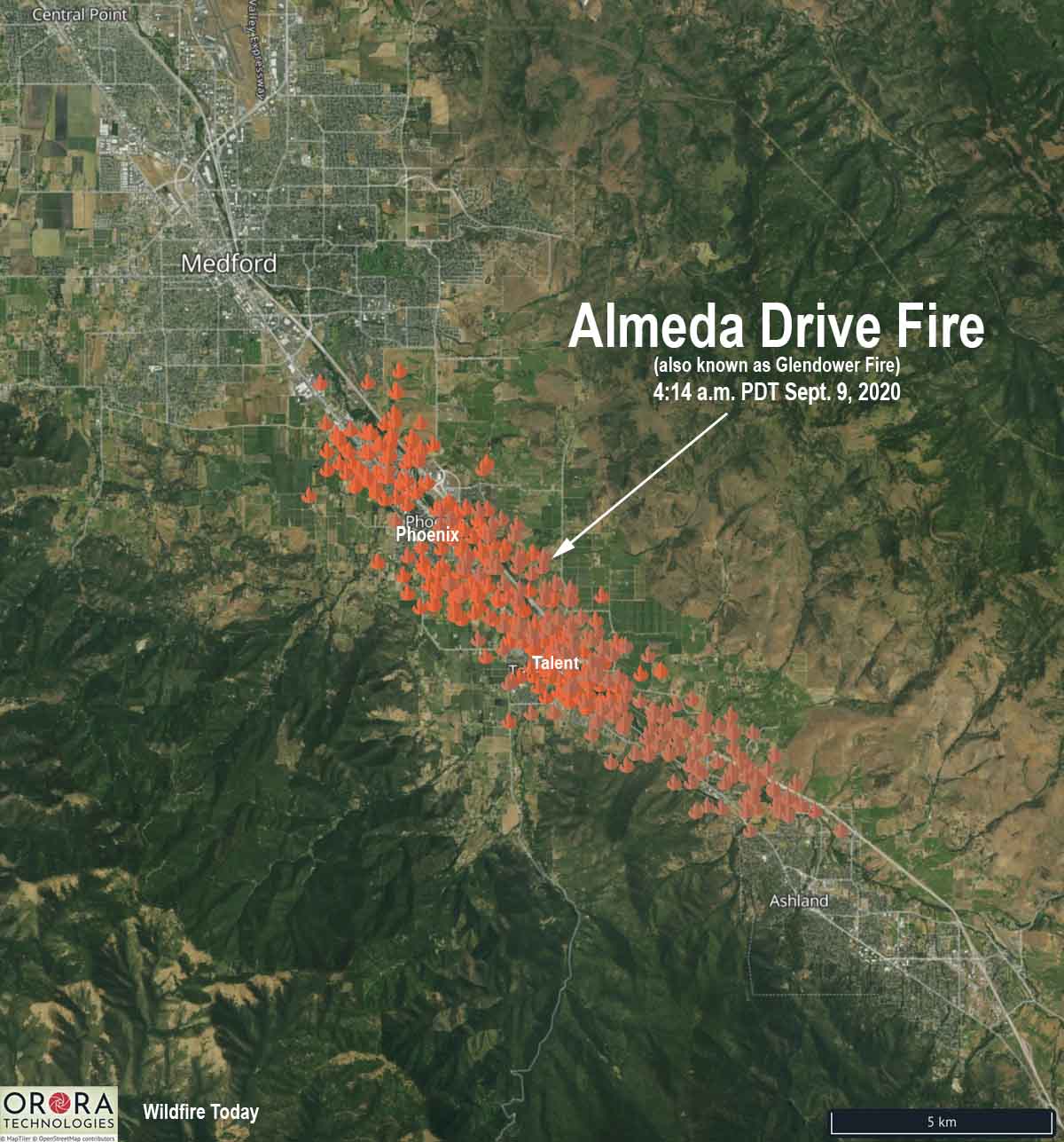
Map of the Almeda Drive Fire (Glendower Fire) at 4:14 a.m. PDT Sept. 9, 2020. The icons represent heat detected by satellites.

Here is an updated map of the Almeda Drive Fire (previously known as Glendower) showing heat detected by satellites at 4:14 a.m. PDT September 9, 2020. There has been much confusion about the name of the fire, but we have information from a fire official that the correct name is Almeda Drive.

The blaze started north of Ashland late Tuesday morning and roughly followed the Interstate 5 corridor as strong winds pushed it northwest. It burned through parts of Talent and by 4:14 a.m. Wednesday was at Phoenix.

Oregon Governor Kate Brown declared the Almeda Drive Fire a conflagration, a large fire which destroys a great deal of land or property. This will allow the state to send resources to assist local agencies.

At about 12:15 Wednesday morning the Oregon Department of Forestry estimated the blaze had burned 2,500 to 3,000 acres.

The Oregon State Fire Marshal incident management team arrived on scene at 1:50 a.m. Wednesday.

Evacuations are in effect for parts of Jackson County and the Medford area. Jackson County and MedfordAlert have evacuation information.


September 8, 2020  |  10:10 p.m. PDT

map Glendower Fire
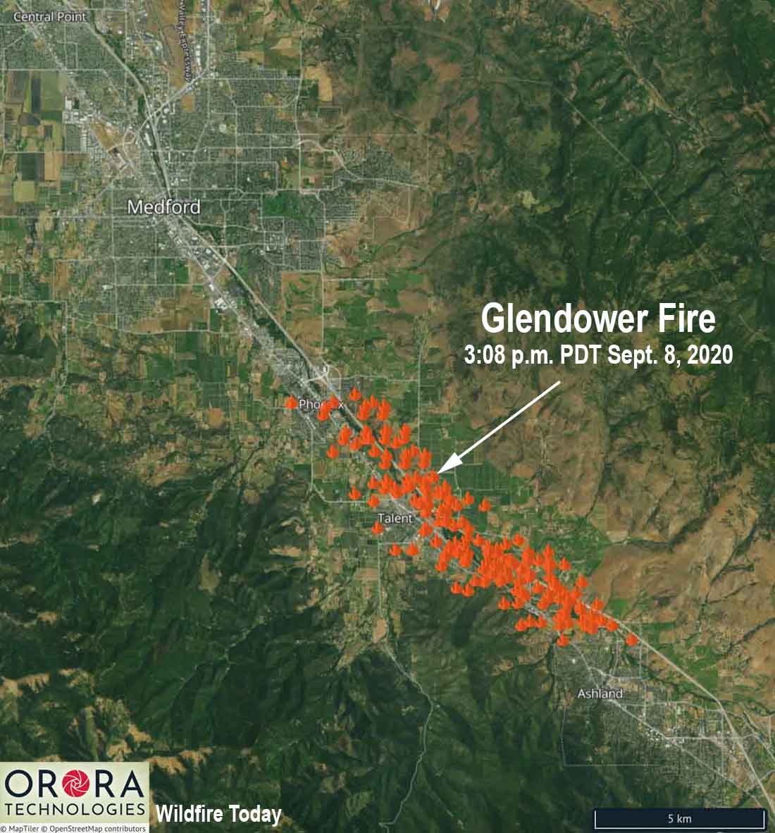
The icons represent heat detected on the Glendower Fire by satellites at 3:08 p.m. PDT September 8, 2020.

The Glendower Fire started north of Ashland, Oregon Tuesday morning then spread northwest along the Interstate 5 corridor (see the map above). At 5 p.m. it prompted evacuations of the entire city of Phoenix, Oregon. The incident is also known as the Almeda Fire.

By 8:45 p.m. evacuations were ordered in areas of Medford and multiple structures had burned. Jackson County and MedfordAlert have evacuation information. MedfordAlert said at 9:56 p.m. an evacuation center has been established at the Josephine County Fairgrounds on Redwood Avenue in Grants Pass. The Jackson County Expo is full.

Tuesday evening sections of Interstate 5 were closed north of the California/Oregon border. TripCheck has current status of the Interstate.

A Red Flag Warning is in effect for the Medford area Tuesday night and Wednesday. The wind direction in Medford will be variable Tuesday night at 3 to 5 mph with the humidity in the teens. On Wednesday the wind will increase at 11 a.m. from the southeast at 15 mph gusting to 23 while the humidity decreases to 7 percent. Wednesday’s high temperature will be 100.

Strong winds spread numerous wildfires in Oregon and Washington

An unprecedented number of fires and acres have burned in recent days

September 8, 2020 | 9:23 p.m. PDT

satellite photo fires smoke Washington, Oregon, and California
GOES-17 photo of smoke from wildfires in Washington, Oregon, and California at 5:56 p.m. PDT Sept. 8, 2020.

The number of wildfires and acres burning in Washington and Oregon are reaching a level that is close to unprecedented in recent memory.

Tuesday afternoon the western one-quarter of Oregon was inundated with dense smoke from multiple fires south of Portland and mostly east of Interstate 5. Strong winds are turning small fires that were ignited weeks ago in Marion County, Oregon into major incidents as law enforcement officers and firefighters try to stay ahead of the fires evacuating residents in their paths.

map wildfires in Washington and Oregon
Map showing heat detected by satellites on wildfires in Washington and Oregon at 4:18 p.m. PDT September 8, 2020.

Thousands of Oregonians were under evacuation orders Tuesday. OPG.org reported that officials said they were so focused on protecting lives and property that suppressing the blazes consuming hundreds of thousands of acres would have to wait. “Our number one priority is evacuation and basic life safety,” said Mariana Ruiz-Temple, chief deputy state fire marshal. “This wind event does not give us the opportunity to really get in there and fight fire how we might fight fire in previous events.”

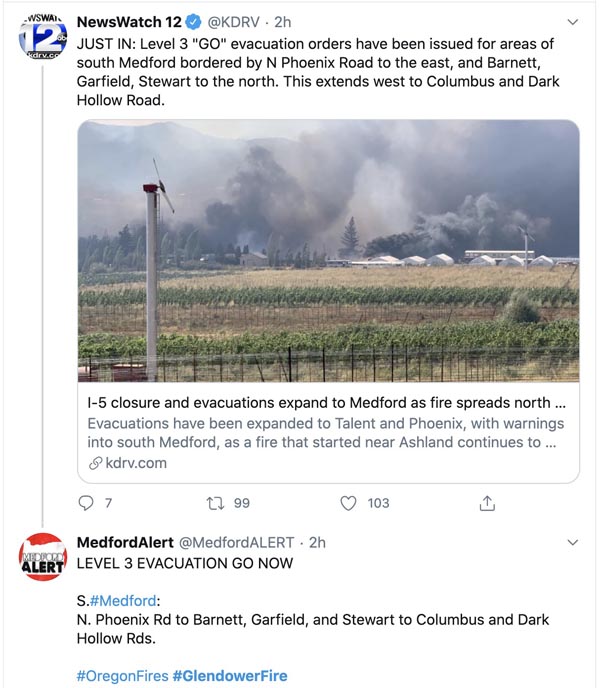
The Glendower Fire started north of Ashland, Oregon then spread northwest along the Interstate 5 corridor into Medford. Much of the city is under evacuation orders and multiple structures have burned. (More information about the Glendower Fire, including a map.)

Glendowner Fire Oregon Medford
Tweet at 7:04 p.m. PDT Sept 8, 2020.

Strong winds accompanying a cold front was the primary force responsible for the rapid spread of the fires, but some of the driest conditions seen in decades led to low moisture content in vegetation that made large quantities of fuel available to quickly ignite.

map wildfires in northwest Oregon
Map showing heat detected by satellites on wildfires in northwest Oregon, south of Portland at 4:18 p.m. PDT September 8, 2020.

The New York Times reported the National Weather Service on Tuesday placed Northwest and southwestern Oregon under an extreme fire danger warning, the first time southern Oregon has been the subject of such a warning, according to the Oregon Climate Office. The Oregon Department of Corrections evacuated 1,450 inmates from three prisons east of Salem.

The New York Times:

Gov. Jay Inslee of Washington said on Tuesday that an estimated 330,000 acres had burned across the state on Monday, more than what burned in each of the last 12 fire seasons. “The devastation is all over our state,” Mr. Inslee said in a news briefing.

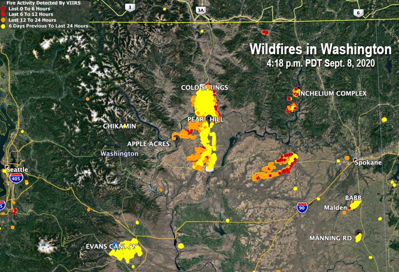
One of the smaller fires in Washington, relatively speaking,  wiped out about 80 percent of the structures in Malden, a town of 200 people south of Spokane. Officials said the buildings that burned included the fire station, post office, city hall, and the library.

Three of the largest blazes in Washington are Cold Springs south of Omak (163,000 acres), Pearl Hill east of Brewster (174,000 acres), and Evans Canyon north of Yakima (75,817 acres). The Pearl Hill fire reportedly burned 170,000 acres within 24 hours.

map fires Washington
Map showing heat detected by satellites on wildfires in Washington at 4:18 p.m. PDT September 8, 2020.

15 firefighters on Dolan Fire became entrapped by the fire and deployed fire shelters

One injury is critical and another is serious, the U.S. Forest Service reported

September 8, 2020  |  5:05 p.m. PDT

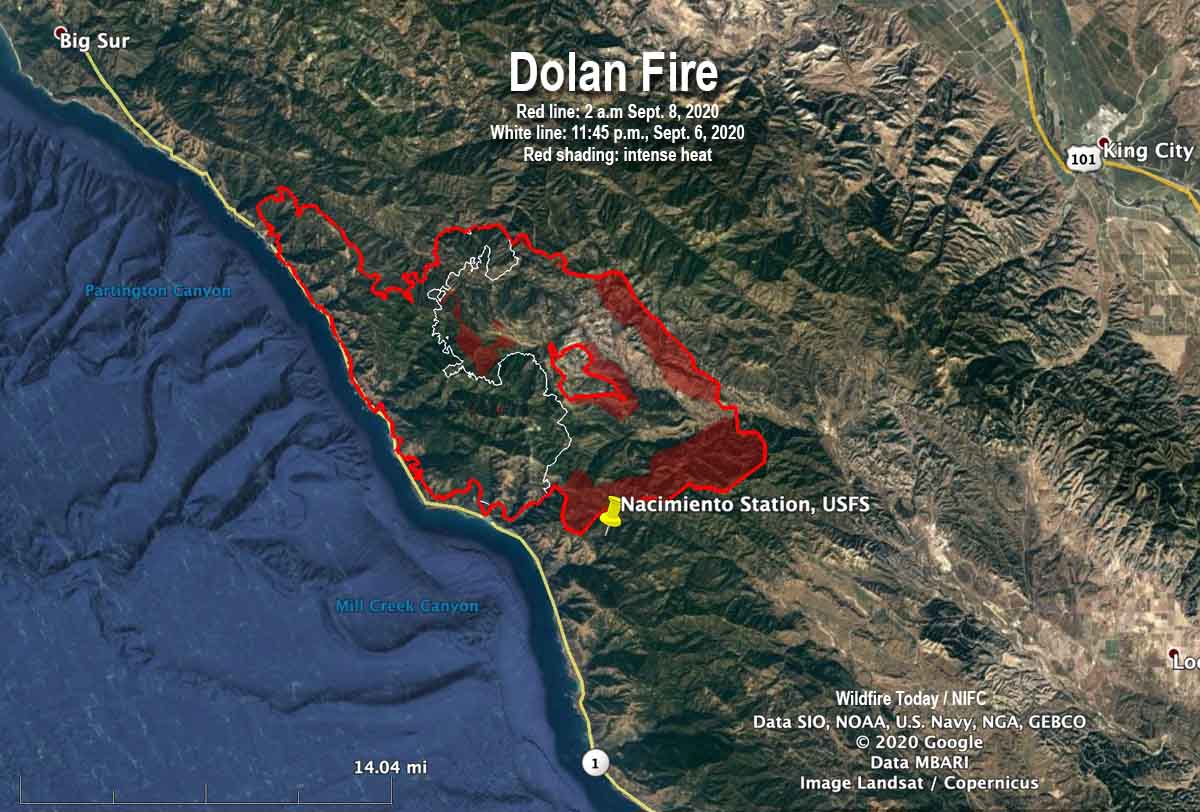
Map of the Dolan Fire
Map of the Dolan Fire. The red line was the perimeter at 2 a.m. PDT September 8, 2020. The white line was the perimeter about 26 hours earlier. Red shading represents intense heat when the fire was mapped.

Fifteen firefighters attempting to prevent a structure from burning in a California wildfire were entrapped and overrun by the fire, the U.S. Forest Service announced today.

Two firefighters were injured, one critically and the other seriously, the release said. Both patients were transported by Life Flight to Community Regional Hospital in Fresno.

(Update September 11, 2020: New information from the U.S. Forest Service is slightly different from what was originally released shortly after the incident. Those new details are in an article published Sept. 11 about another crew that had to deploy fire shelters.)

It occurred at the Dolan Fire at about 8:31 a.m., September 8, 26 air miles southeast of Big Sur.

The firefighters deployed the fire shelters they carry for this type of situation.

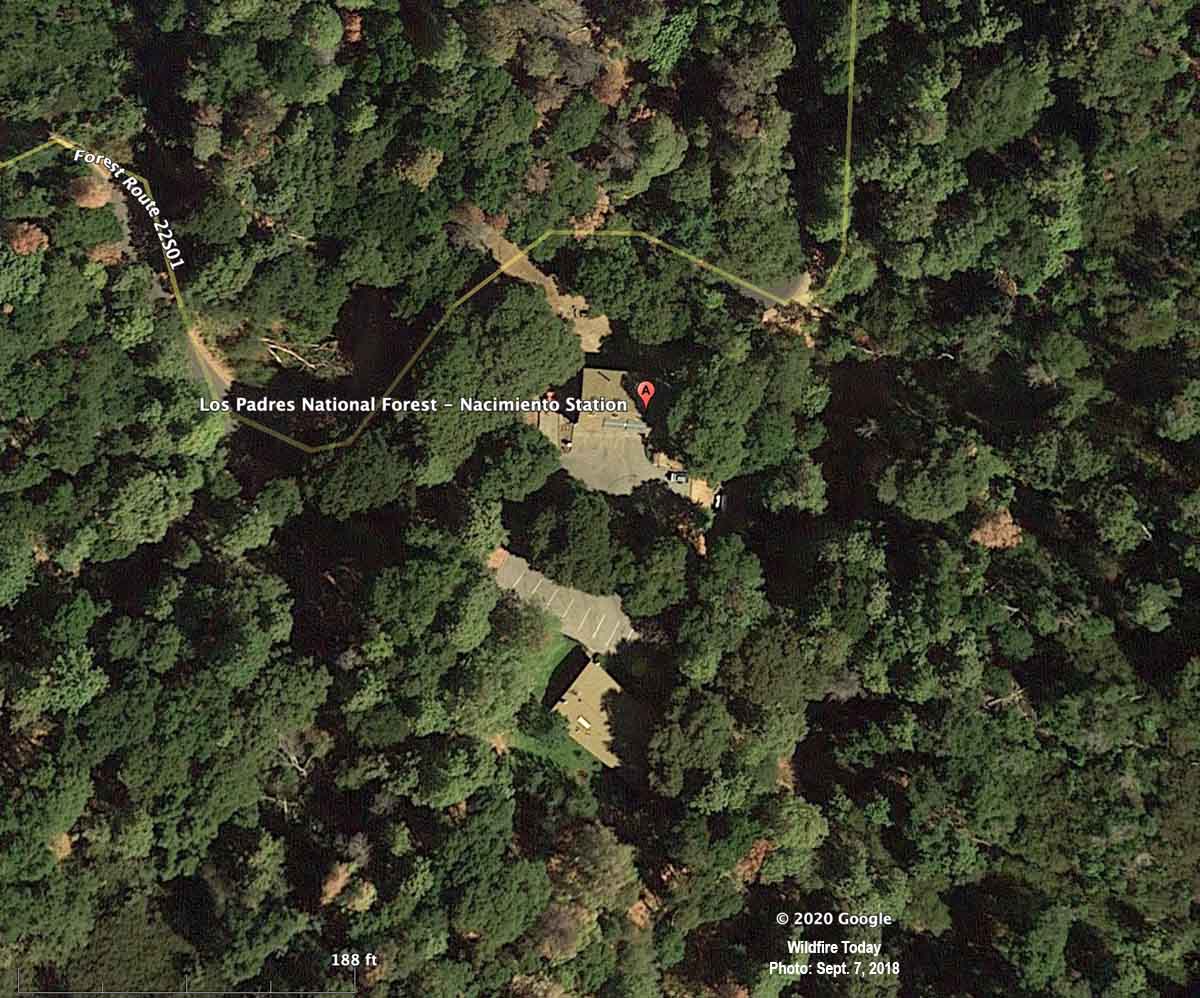
The Forest Service said the incident occurred while the personnel were defending the Nacimiento Station from the approaching fire.

The release from the Forest Service implied more than two of the 15 personnel may have been injured to some degree. Here is an excerpt:

A shelter deployment involving fifteen firefighters from the Dolan Fire occurred approximately at 0831 on Tuesday, Sept 8, 2020, in the vicinity of Nacimiento Station. These dedicated firefighters received injuries including burns and smoke inhalation while defending the Nacimiento Station on Dolan Fire on the Los Padres National Forest in California. Nacimiento Station was destroyed.

When a fixed wing aircraft mapped the Dolan Fire at 2 a.m. PDT September 8 about six hours before the incident, the fire was 74,591 acres, more than twice the size mapped the previous night when it was 36,213 acres. The heat sensing equipment detected intense heat at the fire’s edge at 2 a.m., 0.7 miles northwest of Nacimiento Station.

Fire shelters are small foldable pup tent-like fire resistant devices that a wildland firefighter can unfold and climb into if there is no option for escaping from an approaching inferno. Many firefighters have used the devices successfully, but others have been killed inside them.

Three days before, on September 5, three firefighters on the Bridger Foothills Fire northeast of Bozeman, Montana were forced to deploy and take refuge in their fire shelters when their safety became compromised by the proximity of the blaze, fire officials said.

Nacimiento Station
Nacimiento Station, satellite photo, September 7, 2018.

Thanks and a tip of the hat go out to Al and Tom.