Interstate highway closed after accidents caused by prescribed fire smoke

Investigators will determine if poor visibility was the cause of a fatal accident.

Above: Vehicles at the scene of an accident on Interstate 40 Wednesday, October 19, 2016. Photo by Arizona Department of Public Safety.

(On October 20 we wrote a follow-up article about this incident which looks at the weather forecast and the smoke permit that preceded ignition of the prescribed fire.)

After numerous accidents occurred in thick smoke from a prescribed fire, authorities closed Interstate 40 west of Flagstaff, Arizona on Wednesday. The Kaibab National Forest conducted the burn Tuesday and knew that a wind shift would push the smoke toward the interstate, but they were surprised that the smoke settled near the ground early Wednesday morning rather than being moved out of the area. Electronic signs warned drivers about the potential hazard.

Below is an excerpt from Fox News:

Multiple collisions with minor injuries to motorists and passengers were blamed on smoky haze that settled over the highway for about five hours. Authorities closed I-40 for hours to prevent more accidents.

Police had not immediately determined whether the poor visibility was the cause of a fatal accident after a vehicle was sandwiched between two tractor-trailers before dawn, said Arizona Department of Public safety spokesman Bart Graves.

But the area at this time of year experiences temperature inversions allowing smoke to be trapped close to the ground and hover over the highway, said Cory Mottice, a National Weather Service meteorologist in Flagstaff.

“It almost always gets trapped after dark,” he said. “It’s just a question of where the wind blows it.”

Forest officials thought weather conditions would vent smoke near the freeway more than it did in low-lying areas, Smith said.

“I believed they used good judgment based on the conditions and the information that they had,” said Brady Smith, a U.S. Forest Service spokesperson.

Rainfall in western states slows wildfire season in many areas

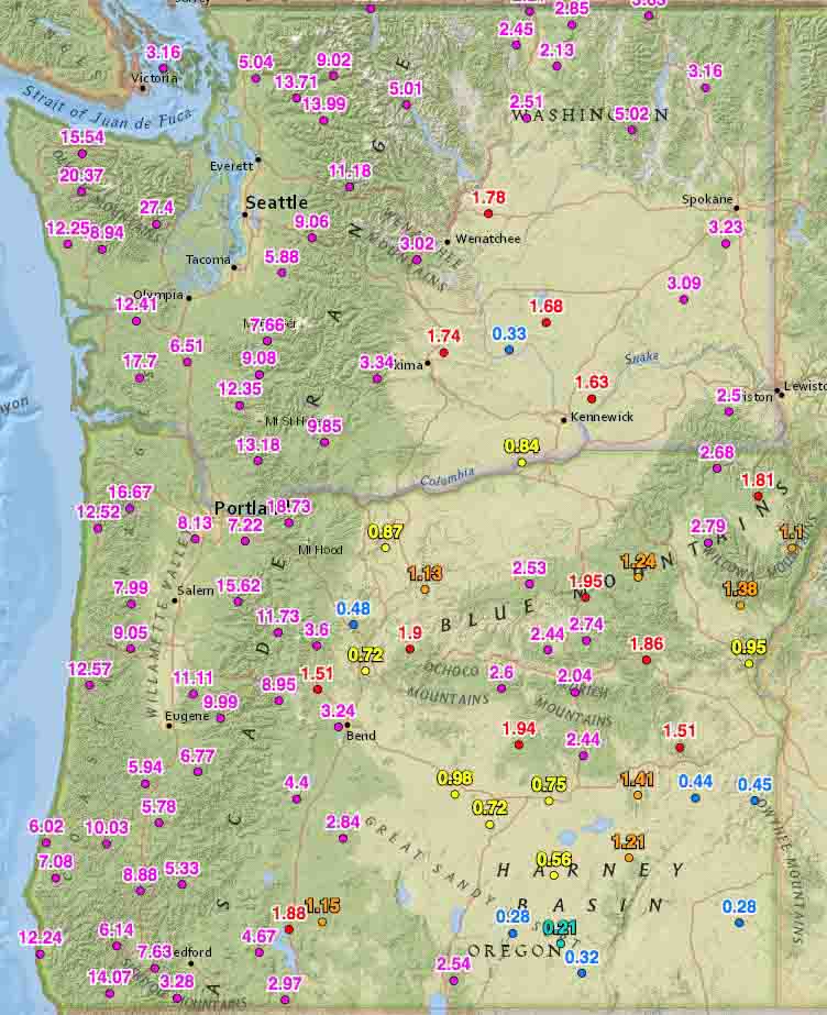
Rainfall last 2 weeks washington oregon
Rainfall last 2 weeks, Washington and Oregon

Rainfall over the last two weeks has slowed or in some cases, ended the wildfire season in some areas.

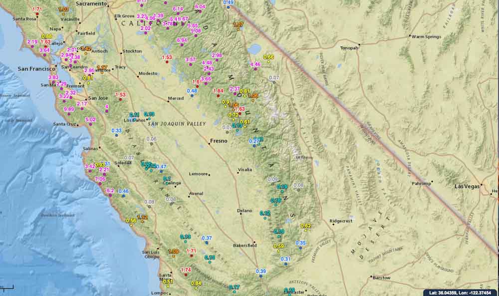
On October 19 we ran the numbers for the accumulated precipitation for the last 14 days in the western states. These maps show amounts that exceeded 0.05 inches at some of the Interagency Remote Automatic Weather Stations (RAWS).

Washington, Oregon, and northern California have received a good soaking and I would imagine that local fire officials may be declaring an end to the fire season. Of course this is not unusual for these areas this time of the year, and some locations had already seen their season end. But what IS unusual, is the high amount of moisture that occurred in just two weeks.

You can click on the images to see larger versions.

Rainfall last 2 weeks, northern California
Rainfall last 2 weeks central California
Rainfall last 2 weeks, central California

Continue to see maps for the other western states.
Continue reading “Rainfall in western states slows wildfire season in many areas”

Sky lanterns cause problems for landowner

Sky lantern
File photo of a sky lantern release in Chiang Mai, Thailand. Photo by Takeaway.

Hundreds of sky lanterns released at an October 15 event 18 miles north of downtown Denver caused problems for at least one landowner five miles away from where they were launched.

A company that makes money by hosting “festivals” where they charge participants who release the small hot air balloons that are lofted by burning fuel at their base, organized an event at the Colorado National Speedway adjacent to Interstate 25.

Below is an excerpt from an article at KDVR:

…”We were watching it not really knowing what it was, but liking it. It was beautiful,” Lauren Gueswel said. She said the view was stunning, until close to 200 lanterns landed on her 40-acre farmland.

“I was extremely concerned and a little angry,” Gueswel said.

Gueswel and her husband chased after the debris while also trying to calm spooked animals.

“Terrified. They were absolutely terrified,” Gueswel said.

The lanterns blew nearly five miles to end up on her property. The couple was worried about dry patches of grass.

“Several of these were landing with embers still burning,” Gueswel said.

A spokesman for the event said the lanterns never hit the ground still hot. Several organizers from the event visited the farm to help pick up the leftover lanterns. They said cleanup is always protocol…

The company that organized the incident, Lantern Fest, had planned to continue releasing the fire-carrying devices on a second night, but it was cancelled due to strong winds. But, they are planning two other events in Colorado — November 5 in Colorado Springs and another one November 6 at the Colorado National Speedway north of Denver.

The company is also planning large-scale releases of the fire balloons near Phoenix, Indianapolis, St. Louis, Albuquerque, El Paso, Austin, Dallas, South Padre Island, Spokane, and Boise.

Colorado is one of the 21 states that still have not banned these dangerous devices.

Thanks and a tip of the hat go out to Allen.

Final size of Cottonwood Fire: 41,360 acres

Above: Final official map of the Cottonwood Fire, produced by the Incident Management Team.

The Cottonwood Fire that started 12 miles east of Wall, South Dakota has been contained. After GPS mapping the 16-mile long fire the incident management team determined it had burned 41,360 acres. Jim Strain, the South Dakota Chief Fire Management Officer, said most of those acres were burned during the first eight hours. And according to Darren Clabo, the South Dakota State Fire Meteorologist, it is the fifth largest on record in the state.

Tuesday night the local Type 3 Incident Management Team was released and turned the fire over to the Wall, Interior, Philip, and Kadoka Fire Departments, the Jackson County Sheriff’s Office, and Buffalo Gap National Grassland.

Livestock losses reported to the Jackson County Sheriff’s Office stand at 137 as no additional losses were reported to the team.

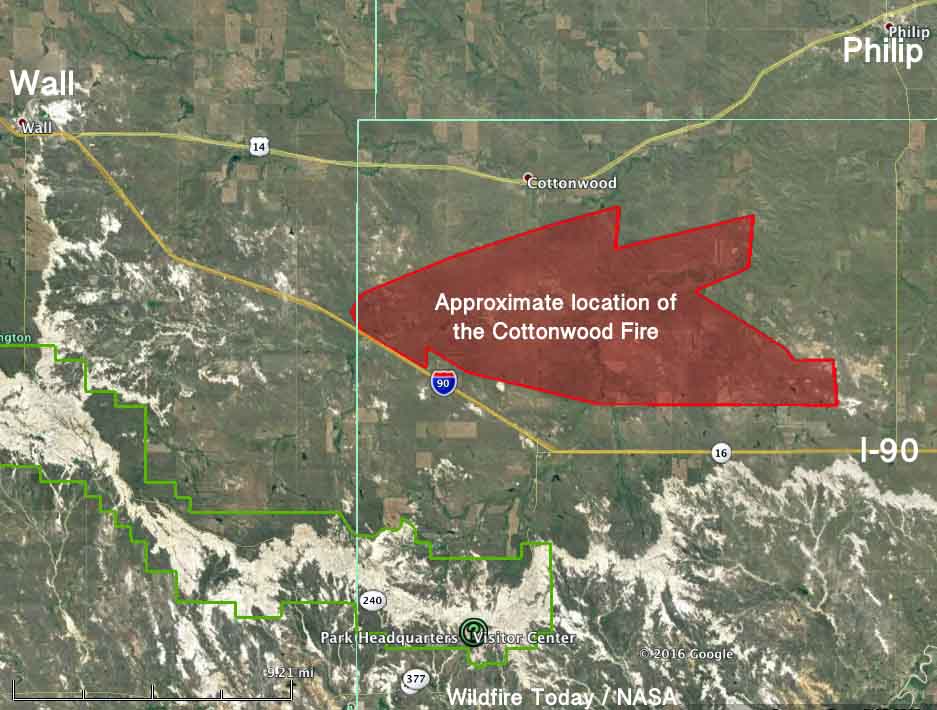
Cottonwood Fire map
The map shows the APPROXIMATE location of the Cottonwood Fire, based on a satellite image from October 18, 2016. The thin green lines are county borders, and the thicker green line at lower-left is Badlands National Park. We made this before the Incident Management Team produced their final more accurate map.

Mr. Clabo sent the tweet below when the estimated size of the fire was 31,000 acres.

Mr. Clablo also looked at the data recorded at the weather station in Badlands National Park south of Wall.

Impressive photo from the Sacata Fire

It took me a few seconds to figure out what I was seeing in this very interesting photo taken by Marta Kroger at the Sacata Fire. It appears to be the shadow of a fire lookout tower projected onto smoke, presumably from the fire, and probably very late in the day or just after sunrise. But I’m at a loss to explain the rainbow effect around the shadow. It’s almost like the tower acted as a prism.

The fire is on the Sierra National Forest 26 air miles northeast of Fresno, California. More information about the fire is here.

Hicks Creek Fire south of Cedar City, Utah

Above: Hicks Creek Fire October 17, 2016. Screen grab from Inciweb video.

The Hicks Creek Fire has burned about 1,100 acres four miles south of Cedar City Utah. The cause is under investigation but a private landowner checking on a smoldering pile of logging debris initially reported it.

From Inciweb:

Firefighters responded at that time and based on dozer lines and other containment features, planned to suppress the fire beginning the following morning. High winds after midnight caused the fire to escape containment resulting in rapid growth and a call for resources.

Strong winds are expected to continue through Tuesday.

The main reason we wanted to tell you about the Hicks Creek Fire was to show you this video. The narrator uses Google Earth to show us around the fire. This is a great idea, and was even enhanced with embedded video and still photos.

Map Hicks Creek Fire
Map of the Hicks Creek Fire at 9:46 p.m. MDT October 17, 2016.