
A year ago today …
News and opinion about wildland fire

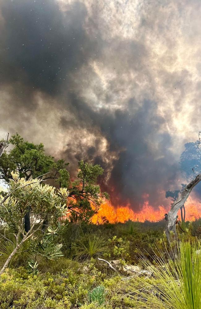
Residents near Perth on the southwestern coast of Australia are being warned to evacuate or risk losing their lives, with an emergency bushfire warning in place.

The bushfire alert was in effect on Monday morning, and the Department of Fire and Emergency Services (DFES) warned that homes and lives were at risk. Residents in other towns including Bindoon, Breera, Gingin, Lennard Brooke, Mooliabeenee, and Moondah were warned that they were “in danger and need to act immediately to survive,” with homes on Wowra Drive and Lennard Road under direct threat by fire.
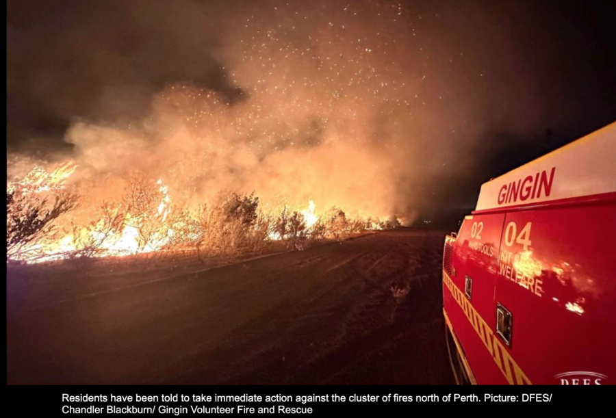
More than 200 firefighters and aviation support staff are fighting the cluster of fires in the Gingin and Chittering shires, and a severe heat warning indicated that temperatures were rising into the mid-forties (40°C = 104°F).
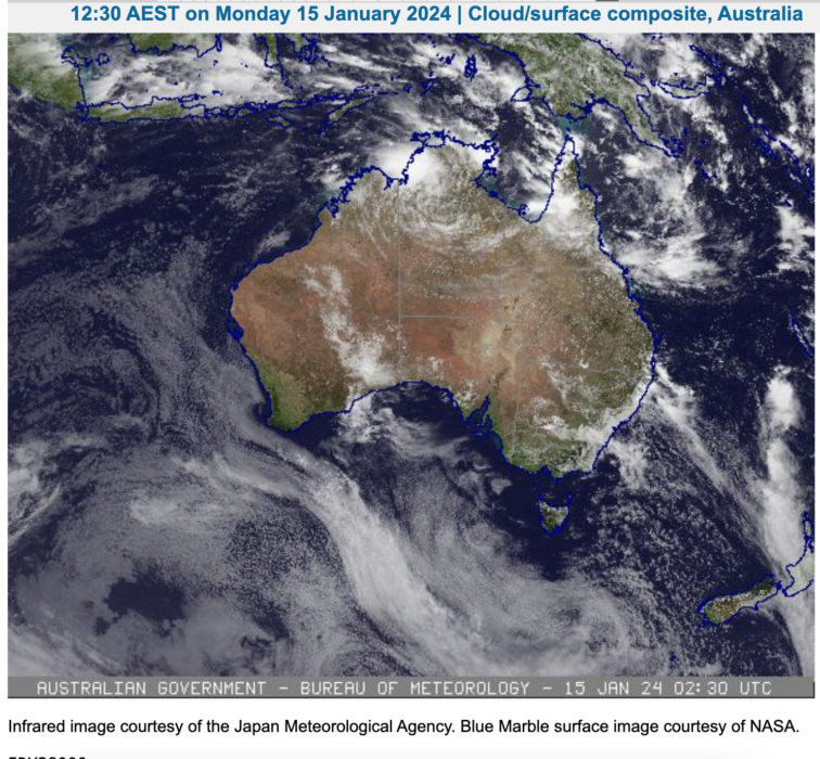
Bushfire-prone weather conditions are expected for the rest of this week, with a thunderstorm warning adding to the fire danger. The Bureau of Meteorology issued an extreme fire danger warning for the areas of Barrup and Blackwood with hot, dry and windy conditions increasing fire danger. Lightning and wind from thunderstorms in the South West Land Division could also ignite and exacerbate fires, and heatwave warnings were issued for much of Western Australia.
Quebec and Ontario’s environmentally crucial boreal forests had a tough wildfire season in 2023. The provinces had 12.8 million and 1.1 million acres burn, respectively.
The 44 million acres burned by wildfires across Canada have been attributed mainly to abnormal drought and high temperatures, but a new study is pointing to another possible factor: the planting of millions of acres of immature trees after widespread logging. A recent study published by researchers at Australia’s Griffith University found more than 35 million acres of Canada’s forests have been lost to logging since 1976, including 20 million acres in Quebec and 14 million acres in Ontario.
The “loss” wasn’t caused by deforestation, which is “land that has been cleared of trees and permanently converted to another use” under Canada’s definition. Rather, the forest has been lost to forest degradation, or the conversion of naturally regenerating forest to plantations of planted trees.
“The Canadian Government claims that its forests have been managed according to the principles of sustainable forest management for many years,” the researchers said, “yet this notion of sustainability is tied mainly to maximizing wood production and ensuring the regeneration of commercially desirable tree species following logging,”
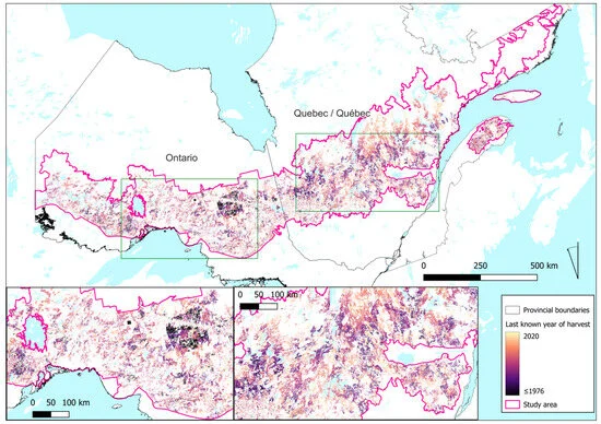
The decrease in the land area of older, more resilient forests across both Quebec and Ontario — and their subsequent replacement with immature trees — both lowered overall forest biodiversity and increased the prevalence of disturbances (wildfire, insect infestations, disease spread) over time.
“Logging has significantly increased the rate of disturbances in this region,” the report said. “This decrease in older forests when compared with historical natural conditions is accompanied by the resulting decline in structural attributes — such as large live and dead standing trees and coarse woody debris associated with older forests — which negatively affects biodiversity.”
The full study is online [HERE].
Quebec and Ontario’s environmentally crucial boreal forests had a tough wildfire season in 2023. The provinces had 12.8 million and 1.1 million acres burn, respectively.
The 44 million acres burned by wildfires across Canada have been attributed mainly to abnormal drought and high temperatures, but a new study is pointing to another possible factor: the planting of millions of acres of immature trees after widespread logging. A recent study published by researchers at Australia’s Griffith University found more than 35 million acres of Canada’s forests have been lost to logging since 1976, including 20 million acres in Quebec and 14 million acres in Ontario.
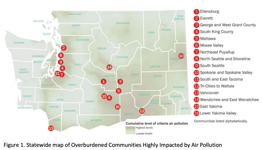
Most of Washington State’s hazardous air pollution comes from wildfire smoke, burdening already over-burdened populations in the state and lowering the average number of years people in those communities are expected to live.
A new report from the state’s Department of Ecology looked into air pollution across Washington and found that the largest contributor to air pollution in over-burdened communities was from wildfire smoke. The DOE is working to improve air quality in 16 places, representing numerous communities, neighborhoods, and towns across Washington that are overburdened and highly impacted by criteria air pollution.
The federal Clean Air Act requires the EPA to set National Ambient Air Quality Standards (NAAQS) for six common air pollutants. The DOE monitors these pollutants and acts if levels become unhealthy. These pollutants are:
During the cold season, the largest contributor to air pollution was usually smoke from wood-burning stoves or furnaces.
Residents of the studied overburdened communities, on average, live 2.4 years shorter lives than the state average and also have higher numbers of deaths from cardiovascular disease.

“Long-term exposure to air pollution may contribute to development of disease — for example, asthma development in children or chronic cardiovascular conditions in adults,” the department’s report says. “Further, short-term exposure to air pollution is associated with exacerbations in existing conditions such as asthma or COPD.”
The overburdened communities included:
The report also warns that life expectancies in these communities may drop even further as the frequency of wildfire smoke events has been rising. The worry is in line with USDA research that points to wildfire seasons in Washington, Oregon, and Idaho that are projected to last longer with increased wildfire frequency, size, and total acres burned as a result of climate change.
“In Northwest forests, a warming climate coupled with more frequent wildfires will lead to a shift away from shade-tolerant, thin-barked, or fire-intolerant species such as western hemlock, subalpine fir, and Engelmann spruce,” the report said. “With warmer and drier conditions and more frequent disturbance, some locations will likely shift from forest to shrubland or grassland.”
Colorado’s wildfire risk map was so inaccurate that state officials just about ignored it — for many years. The map was outdated, especially in western Colorado, where 3+ million acres of forest was covered in beetle-killed pines.
Carolina Manriquez, a lead forester with the state’s forest service, said they were supposed to use the state risk map, but they knew it was not accurate and therefore couldn’t rely on it. As the E&E News recently reported, an infusion of $480,000 in state funds resulted in a new Colorado map with updates including pine beetle damage and densely populated mountain towns.

Including 2017 and 2020, when annual wildfires burned more than 10 million acres, the last decade has marked some of the worst fire seasons in history. The risk is compounded by both climate change and growing wildland/urban interface areas, particularly in the West. Some states — including Colorado, Oregon, Utah, and Texas — have moved toward ensuring their fire risk information and maps are updated and more accurate, displaying areas of highest risk and most in need of prevention and mitigation.

“There is a slowly growing push among different states to do this,” said Joe Scott, founder of Pyrologix in Missoula. The firm provides utility wildfire risk assessment, catastrophe modeling, fuels treatment prioritization and management, and exposure analysis.
To improve wildfire risk maps, many states are partnering with firms such as Pyrologix that can build public-access display of fire risk data and conditions. Using satellite imagery, census information, and other data, advanced tools can determine locations and ranges of ignition probability and fire intensity, along with threatened resource types. Gregory Dillon, director of the USFS fire modeling institute, says the state-specific maps are not a duplication of federal fire maps, but rather a more refined product.
The Kansas Forest Service unveiled in September its new wildfire risk explorer, a digital interactive map that provides a detailed look at statewide fire risk. The effort began in 2018 after several major wildfires including the 2017 Starbuck Fire, which burned some 500,000 acres and destroyed or damaged more than $50 million worth of livestock, fencing, and other resources.
“A lot of state-led efforts are trying to communicate to communities and residents about the risk to private property or municipalities,” said Jolie Pollet, wildfire risk reduction program coordinator at the Department of the Interior.
That’s slightly different from federal mapping efforts focused on protecting federal lands, Pollet said. State-focused mapping can assess evacuation routes, encourage homeowners to reduce their risk, and improve prepared applications for federal grants. State improvements such as those in Kansas also help forestry and fire officials allocate limited resources to focus on the highest priority areas.
India’s Forest Service has reported 1,006 wildfire alerts to the northern state of Uttarakhand since November 1, according to the Times of India. That number is up from the 556 wildfire alerts the service reported during the same time last year.
The increase is part of a worrying and destructive cycle that has escalated in the area for the past six years. Uttarakhand has had triple the acres burned by wildfires since 2017, worsened by its first-ever repeated occurrence of winter wildfires, or wildfires outside of the state’s usual fire season of February 15 to June 15.
“The unusual shift in the fire season may be linked to different reasons including climate change, the lockdown, or too much human intervention in the forests,” Arti Chaudhary, the head of Silviculture and Forest Resource Management Division at the Forest Research Institute, told the Times. “A five-year study across 15 states of the country that witness forest fires, including Uttarakhand, has been initiated to thoroughly understand the actual reasons behind this shift, as it has been recorded all over the country.”
The winter wildfires also contributed to the state’s above-average wildfire carbon emissions in 2021. Uttarakhand’s wildfires emitted an estimated 0.2 megatonnes of carbon in March 2021 alone, breaking a record set in 2003, according to Copernicus Climate Change Service scientist Mark Parrington.
Northern India’s skies took on a hazy hue in November caused in part by the unusual wildfire shift, NASA satellites show. The haze is reportedly a seasonal occurrence caused by urban pollution entering the atmosphere when seasonal weather patterns trap air pollution near the ground, but smoke from the unseasonal wildfires made the air quality even worse.
“The World Health Organization considers 15 micrograms per cubic meter of fine particulate matter (PM2.5) to be a safe limit,” said NASA. “But ground-based air quality monitors routinely measured levels that exceeded 300 and, at times, 500 micrograms per cubic meter in November.”

