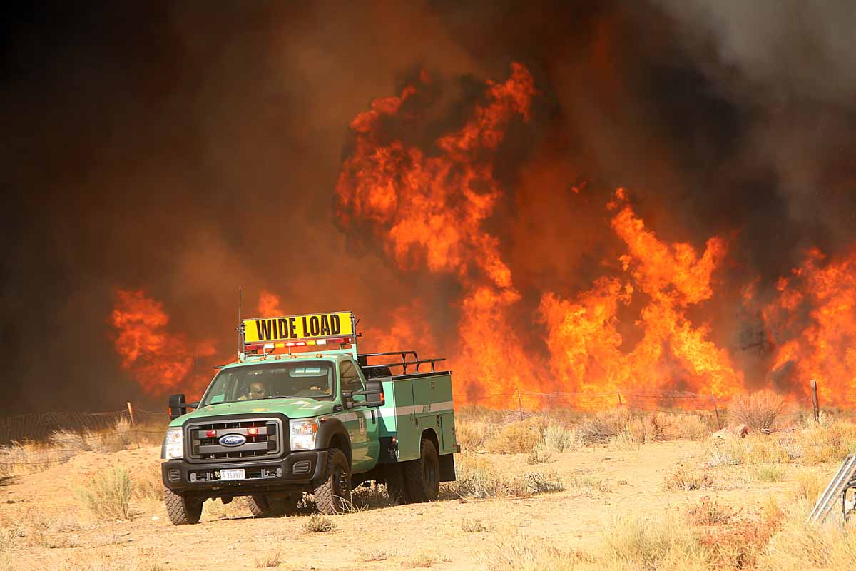
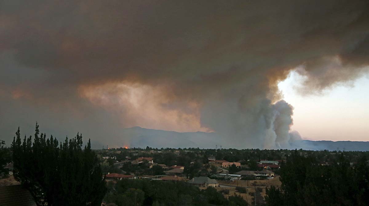
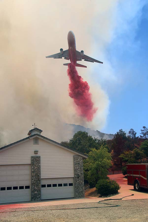
Rey Fire continues to spread to the east

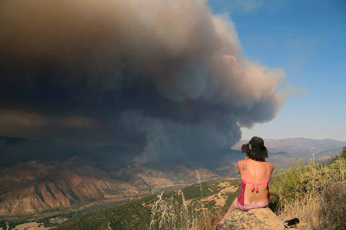
Above: The Rey Fire. Photo by Jeff Zimmerman.

(We published an updated article about the Rey Fire August 24, 2016)

(UPDATED at 8:22 a.m. August 22, 2016)

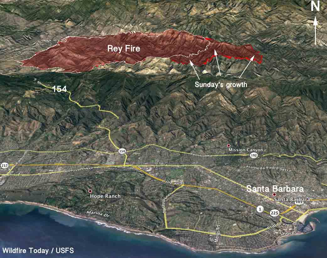
The Rey Fire continued to spread to the east on Sunday, growing by more than 4,000 acres to a total of 23,546. Almost all of the growth was on the east side where it spread for more than 2 miles but it was also active on the northeast perimeter.

3-D Map of the Rey Fire
3-D Map of the Rey Fire. The red line was the perimeter at 10 p.m. PDT Aug 21, 2016. The white line was from about 24 hours before.

The weather conditions at the fire area should be rather mild Monday, for southern California anyway. The temperature will be in the mid-80s under a mostly clear sky and the relative humidity will bottom out in the mid-20s, but the wind could be a concern. It will increase in the afternoon to 10 to 13 mph out of the northwest gusting at 16-20.

The fire is being fought by 1,260 personnel, 28 crews, 48 engines, and 2 helicopters. There are no reports of any structures that burned.

Rey Fire.
Rey Fire. Photo by Jeff Zimmerman.

The time lapse video below of the Rey Fire is mesmerizing. It’s a case study in wildland fire behavior and fire meteorology, featuring wind shear and pyrocumulus clouds. It was shot on August 20 by Jesse Rockwell.

Continue reading “Rey Fire continues to spread to the east”

Cedar Fire causes evacuations west of Kernville, California

In five days the fire has burned over 14,000 acres.

Above: Cedar Fire at 7:40 p.m. PDT August 17, 2016. InciWeb photo.

Mandatory evacuations are in effect in Tulare and Kern Counties northwest of Lake Isabella, California for the Cedar Fire, 32 air miles northeast of Bakersfield and 4 miles west of Kernville.

Since it started August 16 it has burned 14,543 acres according to California Interagency Incident Management Team 5. (UPDATE October 5, 2016: eventually the fire burned 29,322 acres.)

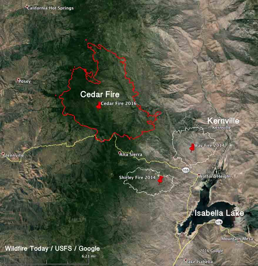
Map of the Cedar Fire
Map of the Cedar Fire at 9 p.m. PDT August 19, 2016. Click to enlarge.

As you can see in the map above, two other large fires occurred in the area in 2014, the Shirley and Way Fires, that burned approximately 2,600 and 4,000 acres respectively. And of course there was also the Erskine Fire in June that blackened about 45,000 acres south of Isabella Lake.

The incident management team provided this information Saturday morning:

No structures have been damaged or destroyed. Firefighters finished wrapping the Tobias Peak and Baker Point Lookouts yesterday, and they remain intact. The significant smoke column that was visible yesterday from nearby communities was generated as the fire burned in the bowl south of Sunday peak on the southwest side. Crews have successfully kept the fire from advancing further south of Highway 155. They continue to brush along the road and mop up along the fireline.

Last night, the fire was active, but less so than the night before. For example, it was primarily backing downslope toward Highway 155 and the community of Panorama Heights. Crews monitored the fire though the night, and on the southeast side they were able to install hose along existing fireline.

One of today’s priorities is to work on perimeter control and hold the fire behind established firelines. Dozer operators will construct more line, and crews with hand tools will fine tune and connect those lines. They will be assisted by aircraft, which are available to water and retardant drops and reconnaissance and mapping flights. Another priority remains the protection of immediately threatened communities.

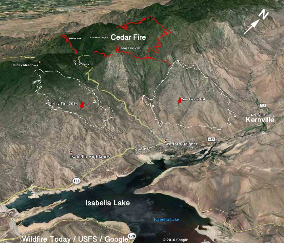
3-D Map of the Cedar Fire
3-D Map of the Cedar Fire at 9 p.m. PDT August 19, 2016. Looking northwest. Click to enlarge.

Man arrested for starting the Clayton Fire and numerous others

(Originally published at 8:55 p.m. PDT August 15, 2016. Updated at 7:46 a.m. PDT August 16 with a list of charges against him and an updated mug shot.)

A man has been arrested for starting the Clayton Fire and numerous others.

Below is an excerpt from an article in The San Francisco Chronicle:

County officials arrested a 40-year-old Clear Lake man Monday on 17 counts of arson related to numerous fires set over the last year, including the 4,000-acre Clayton Fire that has so far claimed 175 buildings and displaced hundreds of people.

Damin Anthony Pashilk

Lake County Sheriff Brian Martin and Cal Fire Chief Ken Pimlott announced the arrest of Damin Pashilk at a community meeting packed with evacuees at a casino doubling as a Red Cross shelter south of the blaze. Residents gasped at the announcement.

Chief Pimlott said Mr. Pashilk had been under investigation for about a year. The charges were enhanced because homes and businesses were destroyed. He has been arrested at least a dozen times before mostly for parole violations, but also on drug and weapons charges.

He was arrested at 4:30 p.m. on August 15 and booked into jail at 12:58 am. August 16. For now he has been charged with:

  1. Arson: structure/forest land
  2. Arson sentence enhancement
  3. Aggravated arson with prior

The sentence enhancement is applicable if homes or businesses were destroyed.

Brian Hickey of KCRA News reports that “aggravated arson with prior” means he has been convicted of arson in the last 10 years.

Bail has been set at $5 million.

The Clayton Fire started Saturday evening and around mid-day on Sunday changed direction after the wind shifted and spread quickly into Lower Lake, California.

180-degree wind shift pushed Clayton Fire into Lower Lake

weather Clayton Fire
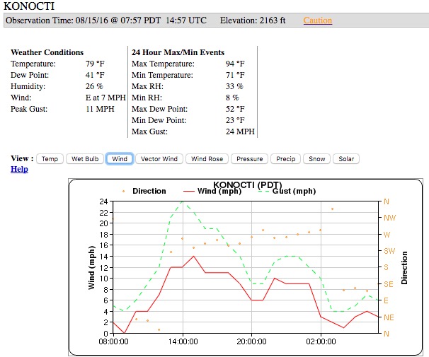
Weather observations at the Konocti weather station just west of Lower Lake, California, from about 8 a.m. on Sunday until 8 a.m. Monday.

The Clayton Fire that burned hundreds of structures in and near Lower Lake, California 31 air miles northeast of Santa Rosa, was rather benign Sunday morning, and some thought firefighters had a handle on it. But later in the day the wind increased and pushed it into the community, spreading much more quickly than firefighters expected or could keep up with.

We checked the weather conditions recorded at the Konocti weather station west of Lower Lake and found that the wind direction shifted by about 180 degrees at mid-day. Before noon there was a north to northeast wind at 0 to 6 mph blowing the fire away from Lower Lake. That changed very suddenly at around noon when the wind became out of the southwest and west at 12 to 14 mph with gusts of 19 to 24 mph. This pushed the fire into the community. The firefighters and other resources that were on hand were not able to keep up with the fire or protect every structure in the town.

At about the same time, the temperature went up to over 90 degrees and the relative humidity dropped from about 30 percent to around 18 percent, and may have briefly hit 8 percent.

Of all of the weather features that affect the behavior of a wildfire, a strong wind can override them all to a degree and control the direction of spread. Topography and fuels (vegetation) also help determine how a fire will spread, but if conditions are dry, wind is the ingredient that firefighters most respect.

Land managers and homeowners can control one of the three factors that determine fire behavior — fuel. It can be removed within 100 feet of structures. Large scale fuel reduction projects in the areas near communities can affect the intensity of a fire when it approaches structures, giving firefighters a chance to save them. But the other two factors, topography and weather, are out of their hands.

Weather forecast for the Clayton Fire area
Weather forecast for the Clayton Fire area, Aug 15, 2016. NWS. Click to enlarge.

The weather forecast for the area of the Clayton Fire predicts clear skies for Monday, a high of 97 degrees, 14 percent relative humidity, and southeast to east winds of 5 to 10 mph. Tuesday will be about the same but with very variable winds blowing from virtually all directions during the day.

Our main article about the Clayton Fire.


Clayton Fire burns more than 175 structures near Lower Lake, California

The fire is burning near the scars from three very large fires from 2015

(UPDATED at 7:35 p.m. PDT August 16, 2016)

The Clayton Fire grew by 67 acres on Monday, but it was on the northeast side near the footprint of last year’s Rocky Fire.  This brings the size of the burned area up to 3,945 acres.

****

(UPDATED at 8:40 p.m. PDT August 15, 2016)

CAL FIRE is now reporting that the size of the Clayton Fire at Lower Lake, California is estimated at 4,000 acres. There has been no change in the number of structures burned.

A man has been arrested for starting the Clayton Fire and numerous others. Below is an excerpt from an article in The San Francisco Chronicle:

County officials arrested a 40-year-old Clear Lake man Monday on 17 counts of arson related to numerous fires set over the last year, including the 4,000-acre Clayton Fire that has so far claimed 175 buildings and displaced hundreds of people.

Lake County Sheriff Brian Martin and Cal Fire Chief Ken Pimlott announced the arrest of Damin Pashilk at a community meeting packed with evacuees at a casino doubling as a Red Cross shelter south of the blaze. Residents gasped at the announcement.

“All 17 counts resulted from a very extensive investigation of numerous fire starts over the last year,” Pimlott said.

****

(UPDATED at 9:03 a.m. PDT August 15, 2016)

CAL FIRE public information officer Daniel Berlant reported at 9 a.m. on Monday that the Clayton Fire has burned approximately 175 structures.

****

(UPDATED at 7:33 a.m. PDT August 15, 2016)

The Clayton Fire burned into the community of Lower Lake, California Sunday afternoon preceded by spot fires started from the burning embers the wind threw out ahead of the blaze igniting many homes and businesses.

At 6:45 a.m. on Monday CAL FIRE estimated that “100+” structures and 3,000 acres have burned.

The fire started Saturday and had died down Sunday morning, but strong erratic winds developed that pushed the fire very rapidly to the north into Lower Lake.

The fire occurred in an area that experienced three large fires in 2015, the Valley, Rocky, and Jerusalem Fires which together burned approximately 159,000 acres.

The Twitter images below are from Sunday afternoon.

****

Originally published at 8:32 p.m. PDT August 14, 2016 Updated at 10:06 p.m. PDT August 14.).

CAL FIRE reports that as of 8 p.m. on Sunday the Clayton Fire has burned 10 structures, including at least 4 residences, near Lower Lake, California, just southeast of Clearlake and 31 air miles northeast of Santa Rosa.

Based on reports from other sources, the actual number of structures destroyed is likely to rise.

After the fire started at 6 p.m. on Saturday, August 13, it burned aggressively north, crossing Morgan Valley Road and Cache Creek, impacting the communities of Lower Lake and Clearlake. St. Helena Hospital in Clearlake has been evacuated. Additional structures are threatened and mandatory evacuations are in place.

Continue reading “Clayton Fire burns more than 175 structures near Lower Lake, California”
Two days in the life of a wildfire photographer

A behind the scenes story of action photography at a fast-moving wildfire in southern California.

Pilot Fire
A dozer tender on the Pilot Fire August 7, 2016. Jeff Zimmerman photo.

Since Jeff Zimmerman retired as a fire captain he spends much of his time photographing fires in California, getting up close and personal with the action. The state has a different, some would say more enlightened, way of handling the media at emergencies and disasters than some other areas. There are few restrictions as long as they do not interfere with incident operations (see California Penal Code 409.5d).

Jeff covered the Pilot Fire that so far has burned almost 8,000 acres in southern California near Crestline. He was there for the first two days, took these photos, and wrote down some of his thoughts.

****

By Jeff Zimmerman

During the late afternoon of August 7, 2016, I received word from Tod Sudmeier about a fast moving wildfire along Highway 138 and Pilot rock in San Bernardino County. The first reports were that the fire was not accessible so I did not pay much attention to the pager. An hour after the initial alert rang out, the fire was reported to be a 1,000 acres and moving towards Highway 173 in Summit Valley. With this new information I responded from Towsley Park, cutting my nature hike short.

There was sweltering heat once again in Southern California, which appears to be the new norm, as monsoon moisture had moved to the east and relative humidity was rock bottom. The skies above the desert were clear blue but temperatures were soaring to triple digits.

Pilot Fire
PIlot Fire August 7 2016. Jeff Zimmerman photo.

Once again responding up the long trek of Highway 14 as I have numerous times before, I went east onto Pearblossom Highway and over the summit to Highway 138. A large plume of smoke was clearly visible — another major emergency wildfire threatening homes, chewing through decades old brush, threatening human and animal life. Insatiable flames were bearing down on rural ranches as people packed up livestock in trailers to get away from the menacing flames. Air tankers roared into the valley to cut off the advancing fire from the 17525 block of Highway 173. The fire was marching northeast at a rapid clip, dozers frantically working the fire line to halt advancing flames, but with little success.

This had the makings of yet another dangerous fire, probably human caused, possibly by negligence, hopefully not by arson. I continued through the flame front as the fire jumped Highway 173 and into the spillways of Lake Silverwood. Always moving to stay ahead of the flames, only powered by pure adrenalin and Gatorade, I reluctantly moved up canyon, seemingly to dance with the red devil. By nightfall it was evident that the fire was creeping up the steep brush covered desert slopes moving towards Lake Arrowhead up old Highway 173 into no man’s land. Old Highway 173 is now abandoned and will tear the front end off your vehicle off if you attempt to traverse it.

By twilight it looked as if a nuclear bomb had dropped over Summit Valley and ash was raining down on Hesperia nine miles to the north. Curious onlookers were wondering just how far this fire would travel and could it make it into Hesperia proper. Day was turning to night so a few more hours of shooting then it was time to call it quits.

At 11 p.m. I realized I needed to leave the scene, upload a few images, and get a few hours of rest. By 1 a.m. I arrived home, transferred photos into my computer, took a quick shower and went off to bed. Oh, how I know too well, the magic hour of 2 a.m.; finally some badly needed rest on an old lumpy mattress. I always hate those nagging heat cramps being so dehydrated; now the push is on to get fluids back into the body.

At 6 a.m. I was back at my daily chores, watering the crops, charging camera batteries, double-fisting coffee, grabbing a quick bite to eat, and then out the front door. I met Bernie Deyo in Palmdale at Ave S Park-and-Ride and it was off to the races again. The smoke was already billowing along Highway 173 at 10 a.m. We made a quick stop at Highway 138 and 15 freeways to stretch, pick up lunch at Del Taco. Then it was back onto the firelines.

By noon the fire was rolling, boiling behind homes. Structure protection was now in place and San Bernardino County firefighters from Medic Engine 224 were hunkering down behind a home with a charged 1 ½ inch hose line trying to protect the residence from fire. We parked facing out on a small dirt driveway, ready to escape the flames at a moment’s notice.

PIlot Fire Continue reading “Two days in the life of a wildfire photographer”