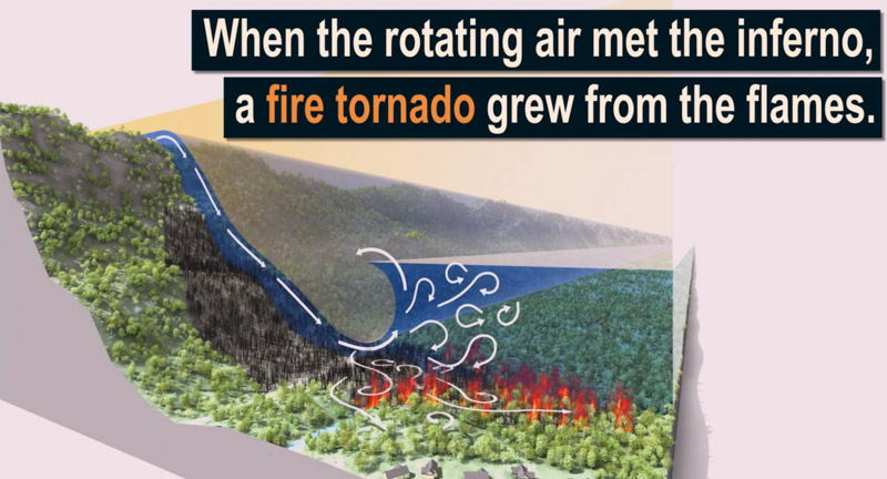
Video: how the fire tornado formed at the Carr Fire

formation fire tornado Carr Fire
Early stage in the formation of the fire tornado at the Carr Fire, July 26, 2018. Screenshot from Scientific American video below.

Scientific American has produced a video that describes the formation of the fire tornado that burned and scoured a mile-long path as the Carr Fire burned into Redding, California July 26, 2018.

In the video below, click on the little square at bottom-right to see it in full screen.

There were two fatalities on the Carr Fire that day. Redding Fire Department Inspector Jeremy Stoke was burned over in his truck on Buenaventura Boulevard. On the other side of the Sacramento River, on the west side, Don Ray Smith was entrapped and killed in his dozer.

According to a Green Sheet report by CAL FIRE, the conditions that resulted in the entrapment of three dozers and the Redding Fire Department Fire Inspector that day were due to the fire tornado — a large rotating fire plume that was roughly 1,000 feet in diameter. The winds at the base were 136-165 mph (EF-3 tornado strength), as indicated by wind damage to large oak trees, scouring of the ground surface, damage to roofs of houses, and lofting of large steel power line support towers, vehicles, and a steel marine shipping container. Multiple fire vehicles had their windows blown out and their bodies damaged by flying debris.

The strong winds caused the fire to burn all live vegetation less than 1 inch in diameter. Peak temperatures likely exceeded 2,700 °F.

The Carr Fire burned 229,651 acres, destroyed 1,077 homes, and killed 3 firefighters and 5 civilians

The news media sometimes calls any little fire whirl a “fire tornado”, or even a “firenado”. These and related terms (except for “firenado”) were, if not founded, at least documented and defined in 1978 by a researcher for the National Weather Service in Missoula, David W. Goens. He grouped fire whirls into four classes:

  1. Fire Devils. They are a natural part of fire turbulence with little influence on fire behavior or spread. They are usually on the order of 3 to 33 feet in diameter and have rotational velocities less than 22 MPH.
  2. Fire Whirls. A meld of the fire, topograph, and meteorological factors. These play a significant role in fire spread and hazard to control personnel. The average size of this class is usually 33 to 100 feet, with rotational velocities of 22 to 67 MPH.
  3. Fire Tornadoes. These systems begin to dominate the large scale fire dynamics. They lead to extreme hazard and control problems. In size, they average 100 to 1,000 feet in diameter and have rotational velocities up to 90 MPH.
  4. Fire Storm. Fire behavior is extremely violent. Diameters have been observed to be from 1,000 to 10,000 feet and winds estimated in excess of 110 MPH. This is a rare phenomenon and hopefully one that is so unlikely in the forest environment that it can be disregarded.”

Thanks and a tip of the hat go out to Rick. Typos or errors, report them HERE.

California bans insurers from dropping policies in wildfire areas

It will apply for one year after the Governor declared a state of emergency

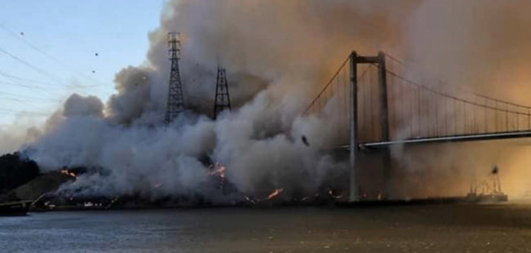
Glen Cove Fire
Glen Cove Fire south of south of Vallejo, California, northeast of the I-80 Carquinez Bridge, October 27, 2019. Photo by @arrowstewtoe.

The California Department of Insurance is invoking a law passed in 2018 that bans insurance companies from dropping or refusing to renew homeowners policies in zip codes within or adjacent to the perimeters of recent fires. This will apply for one year after the Governor declared a state of emergency in October, 2018 and will affect at least 800,000 homes in wildfire disaster areas in Northern and Southern California. The action by Insurance Commissioner Ricardo Lara is the result of Senate Bill 824 that he authored last year while serving as state senator.

In his announcement about the localized ban, the Commissioner went a step further and called on insurance companies to voluntarily cease all non-renewals related to wildfire risk statewide until December 5, 2020.

Many homeowners in California are finding that the premiums on their policies have doubled or tripled in the last two years, and insurance companies in some cases are canceling or refusing to renew policies on residences in areas where wildfires have occurred. California’s property insurers are beginning to retreat from areas they identify as having higher wildfire risk.

Local governments are concerned that this trend could disrupt local real estate markets and cause property values to decline, reducing tax revenue available for vital services to residents such as fire protection, community fire mitigation, law enforcement, road repairs, and hospitals.

The California Department of Insurance has identified some of the zip codes affected by the temporary ban on dropping or refusing to renew homeowners policies. The following fires with the affected zip codes are listed: Saddleridge, Eagle, Kincade, Tick, Getty, Hill, and Maria.

CAL FIRE has not yet provided the fire perimeter maps for the Water, 46, Hillside, Easy, Sky, and Glen Cove Fires, therefore the zip codes near these fires is not yet available.


Opinion: Could this be a tipping point?

I have wondered for years when the insurance companies were going to drastically raise their rates or refuse to issue policies in wildfire-prone areas. I figured that when it occurred it could be a tipping point that could lead to broad positive actions affecting the resiliency of communities at risk from wildfires. Either that, or those areas could experience significant outward migration of residents, causing economic disruption.

Fire-prone communities, if they are going to survive over the long term, have to learn to live with fire. Sticking their heads in the sand and thinking fires can’t happen to them is not recognizing reality.

Earlier this year I wrote an article about “Five things that need to be done to protect fire-prone communities”. In areas where they are adopted insurance companies could recognize that homes would be less likely burn in a wildfire and adjust their rates accordingly.

Here are the broad areas that need to be considered:

  1. Home spacing and lot size
  2. Envelope of  the structure itself
  3. Home ignition zone
  4. Community infrastructure and planning
  5. Wildland-urban interface

The only effective way to ensure that residents understand and implement these five tasks is to make them mandatory by establishing Fire Codes at the local and state levels.

Power company evaluating multiple failures on transmission towers as causes of large wildfires

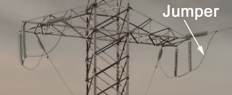
jumper cable high voltage electrical transmission tower
File photo of a jumper cable on a high voltage electrical transmission tower.

Pacific Gas & Electric (PG&E) told a judge on November 29 that it is investigating whether there is a systemic problem with a piece of hardware on their high voltage electrical transmission towers that can start wildfires, the San Francisco Chronicle reported. Investigators with PG&E and the California Department of Forestry and Fire Protection are looking at the possible failure of jumper cables on towers near the points of origin of two huge recent fires, the 2017 Camp Fire at Paradise, California and the Kincade Fire that started near the Geysers north of Santa Rosa October 23, 2019.

The Chronicle reported that “PG&E is also seeking more generally to determine whether there may be jumper cables that may be susceptible to failure for any reason in PG&E’s system,” the company told U.S. District Judge William Alsup.

It has been determined that PG&E equipment started the Camp Fire, but officially the cause of the Kincade fire is still under investigation.

On October 24 PG&E filed a required preliminary report with the California Public Utilities Commission that stated “at approximately (9:20 p.m.) on Oct. 23, PG&E became aware of a Transmission level outage on the Geysers No. 9 Lakeville 230kV line when the line relayed and did not reclose. At approximately (7:30 a.m.) on Oct. 24, a responding PG&E Troubleman patrolling the Geysers No. 9 Lakeville 230 kV line observed that CalFire had taped off the area around the base of transmission tower 001/006. On site CalFire personnel brought to the Troubleman’s attention what appeared to be a broken jumper on the same tower.”

Jumper cables are used on high voltage lines to route the wires around the metal tower so the electricity is not conducted into the structure. If a piece of hardware that supports the jumpers fails, the jumper wire breaks, or if it comes in contact with the steel tower, massive arcing will occur sending sparks and molten metal flying, which can ignite anything on the ground that is flammable.

The video below shows the ignition of the Kincade Fire on October 23 as seen in near infrared from a camera at Barham near Geyserville, California. Keep your eye on the bright light on the horizon left of center. It disappears at about 21:19:55 and 15 seconds later the fire can be seen growing rapidly.

Video shows photographer’s withdrawal while covering Cave Fire

FirePhotoGirl's dash cam video fire
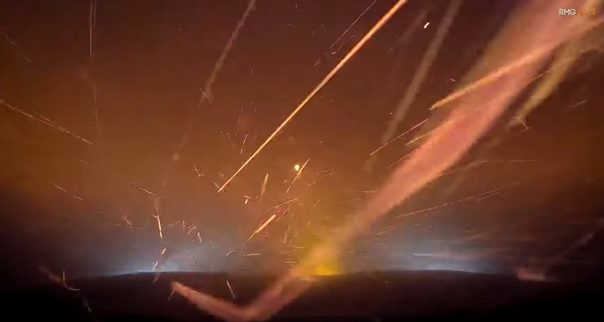
Screenshot from FirePhotoGirl’s dash cam video before she turned around on Painted Cave Road. Used with her permission.

While reporting on the Cave Fire near Santa Barbara, California a fire photographer encountered a little more wildfire activity than she expected.

FirePhotoGirl is very active in coverage of fires and other emergency incidents, shooting footage for Southern California media as well as her twitter account, @FirePhotoGirl.

On November 25 just before midnight she was on the Cave Fire driving her vehicle down Painted Cave Road when she made what looks like a good decision to turn around. She described it like this when posting the dash cam video on YouTube:

Painted Cave – I was trying to go down and had to turn around. If you cant tell it was a little too warm. Do not try this or put yourself in harms way. This was very dangerous.

(Click here to see all articles on the Cave Fire, including the most recent)

The Cave Fire burned 4,330 acres northwest of Santa Barbara until rain and in the higher elevations, snow, stopped the spread November 27, 2019.

New real time mapping system used on Cave Fire

Fire Integrated Real-Time Intelligence System (FIRIS)
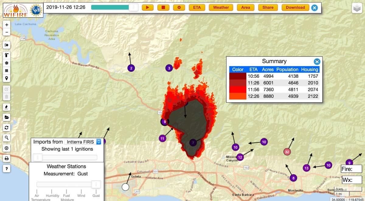
An example of an output from the Fire Integrated Real-Time Intelligence System (FIRIS) used on the Cave Fire near Santa Barbara, CA November 26, 2019. The dots with arrows represent weather stations. Inciweb.

A new real time wildfire mapping system was used on the Cave Fire near Santa Barbara, California this week.

In September the Orange County Fire Authority began a 150-day pilot program to use and evaluate the Fire Integrated Real-Time Intelligence System (FIRIS). The program got off the ground thanks to funding secured in the 2019-2020 California state budget by Assemblywoman Cottie Petrie-Norris (D-Laguna Beach).

The system utilizes a fixed-wing aircraft equipped with infrared and radar sensors that can see through smoke. The plane provides real-time fire perimeter mapping and live high definition video to support supercomputer-based wildfire predictive spread modeling.

(Click here to see all articles on the Cave Fire, including the most recent)

FIRIS fire wildfire mapping real time
Screenshot of aircraft featured in the FIRIS B-Roll video.

A supercomputer at the University of California San Diego runs WIFIRE spread projections based on fire perimeter data collected by the aircraft. The output estimates where the fire will be in the next six hours. The fire spread model adjusts for successful fire suppression actions by firefighters on the ground and in the air. This intel allows for more timely and accurate decision making for resource allocation and evacuations.

flight path N4717V fire mapping
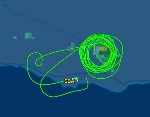
The flight path of N4717V, a Turbo Commander 690, also known as “AC90”. It was orbiting over the Cave Fire at 12,400 feet on November 26, 2019. Flightaware map.
AC90 mapping aircraft wildfire
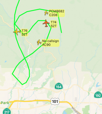
The FIRIS aircraft, shown as “AC90”, was over the Cave Fire along with two S-2T air tankers, at 7:52 a.m. November 26, 2019. Flightradar24

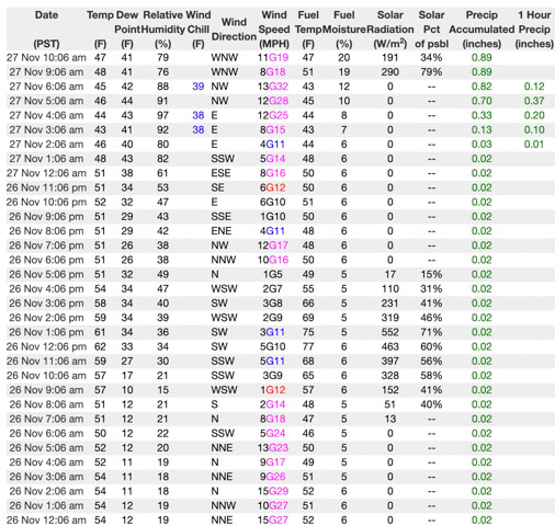
If I am correctly interpreting the WIFIRE product at the top of this article the system predicted that the Cave Fire would grow from 4,994 to 8,880 acres over a 90-minute period beginning at 10:56 a.m. on November 26, 2019. Spot fires were predicted more than a mile ahead. However, decreasing winds that day slowed the spread. A weather station in San Marcos Pass about three miles northwest of the fire recorded sustained wind speeds from 1 to 5 mph between 10 a.m. and 5 p.m. Rain beginning at 2 a.m. November 27 stopped  the spread at 4,330 acres.

Weather San Marcos Pass
Weather at San Marcos Pass, November 26-27, 2019.

The video below is “B-Roll”, that is, unedited footage of the FIRIS system. The first 6.5 minutes are simply images of aircraft, but after that you will be able to look over the shoulder of the imagery technician as he observes infrared imagery of a fire, manually interprets the heat signatures, then traces the fire perimeter on the screen. That perimeter could then be electronically sent to the super computer in San Diego County which would run a fire spread model to predict what the fire will do in the next six hours.

Our attempts to obtain more information about FIRIS from personnel on the Cave Fire that used the system were not successful.

Rain aids containment of Cave Fire

Evacuees could be back in their homes by the end of the day Wednesday

map Cave Fire November 26 2019
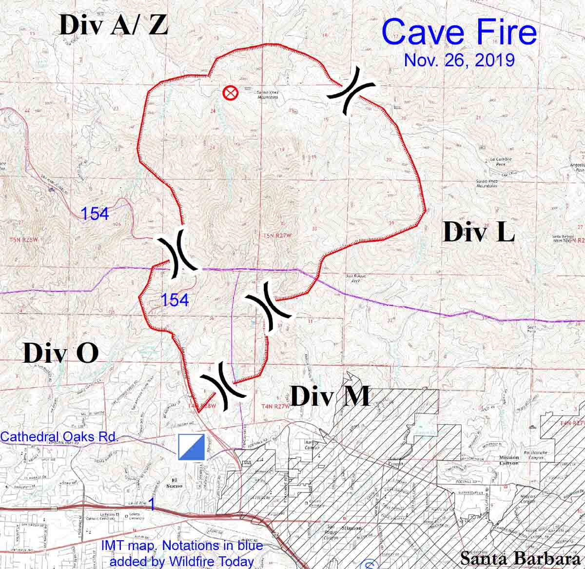
Map of the Cave Fire, November 26, 2019. Produced by the incident management team. Notations in blue by Wildfire Today.

10:01 a.m. PST November 27, 2019

The predicted rain that would stop the spread of the Cave Fire near Santa Barbara arrived at 2 a.m. Wednesday, four hours after it was expected, but by 9 a.m. had accumulated 0.87 inch in the weather station in San Marcos Pass. An additional 1.3″ through Thursday night is in the forecast.

Mike Eliason, an Information Officer for Santa Barbara County Fire Department, said Wednesday morning that there is a slight chance of snow in the higher elevations of the fire. The lowest edge of the fire at Santa Barbara is at 300 feet, but the ridge near the north side rises to 3,500 feet.

(Click here to see all articles on the Cave Fire, including the most recent)

Plans to repopulate evacuated areas are under evaluation. Mr. Eliason said everyone should be back in their homes by the end of the day on Wednesday.

The latest mapping puts the fire at 4,330 acres. There are still residual smokes visible and Highway 154, with fire on both sides, remains closed. Demobilization of firefighters will begin today.

Well over 90 percent of the fire is on land managed by the Los Padres National Forest, but the suppression was carried out by a unified command also representing Santa Barbara County and CAL FIRE.

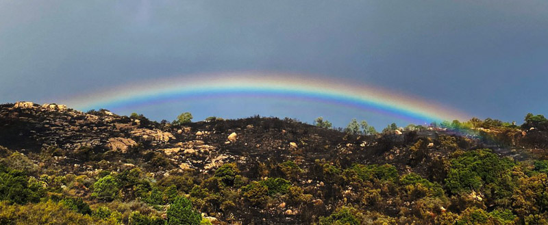
Rainbow Cave Fire
Rainbow over the Cave Fire near Painted Cave Road Wednesday morning. Mike Eliason photo for SBCFD.