400 firefighter hand crews are deployed on fires in the United States

Above: A firefighter ignites a burnout on the Powerline Fire southwest of Pocatello, Idaho. Uncredited Inciweb photo, posted August 6, 2017.

(Originally published at 12:48 p.m. MDT August 6, 2017)

Wildland firefighters are much busier this year than in a typical year. To date, fires have burned 46 percent more acres than the 10-year average — 5,820,802 acres vs. the 3,962,906 average. In some years fire activity in Alaska, where many very large fires are not suppressed, can inflate these numbers, but so far that state can only account for 626,786 acres, not a huge number for Alaska.

400 hand crews, usually comprised of 20 people each, are deployed nationwide, along with 949 fire engines, and 120 helicopters for a total of 16,673 personnel.
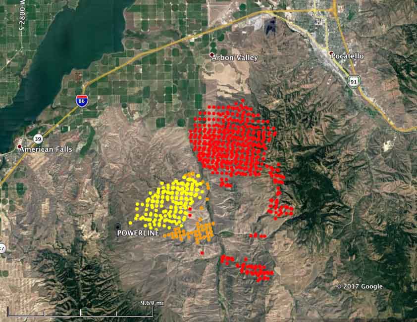
map powerline fire
Map showing heat detected on the Powerline Fire southwest of Pocatello, Idaho by a satellite August 5 and 6, 2016. The red dots are the most current, at 4:04 a.m. MDT August 6. Some areas with light vegetation, such as grass, may have burned and cooled before the satellite overflight and were not detected.

Here are brief descriptions of some of the larger or more prominent fires:

  • Powerline (see the map and photo above): Since it was reported Friday night this fire has spread very rapidly. Saturday it was very active on the northeast and southeast sides. Using satellite data the Incident Management Team estimated early Sunday morning that it had burned over 40,000 acres, but that is a very rough guess. More accurate mapping by fixed wing aircraft will provide better numbers. The satellite information indicated that by 4:04 a.m. Sunday it had spread to within 6 miles of Pocatello, Idaho. It is moving into steeper terrain with heavier fuels, offering more resistance to control and is the #2 priority in the Great Basin Geographic Area according to the national situation report.
  • Mammoth Cave, southwest of Carey, Idaho. Since it started August 4 it has burned three structures and 30,000 acres. It is the number 1 priority in the Great Basin Geographic Area.
  • The Shoestring Fire between Shoshone and Gooding, Idaho has blackened about 12,000 acres since it started August 5. It is the #3 priority in the Great Basin Geographic Area.
  • The Rice Ridge Fire northeast of Seeley Lake, MT is the #1 priority in the Northern Rockies Geographic Area and is threatening over 1,000 structures. It added almost 700 acres on Saturday to bring the total to 7,740.
  • The Sunrise Fire, 12,900 acres, the #2 priority in the Northern Rockies Geographic Area, grew by 600 acres Saturday. It has been burning since July 16, growing every day, adding several hundred acres daily on the east or northeast sides. It is now mapped at 12,900 acres.
  • The Hanover Fire, in a very remote area 15 miles northwest of Riggins, Idaho, was extremely active on Saturday. The Incident Management Team reports that it has burned 4,479 acres.
  • Parker 2, 10 miles east of Alturas, California. It was very active Saturday, adding 5,300 acres, growing to 7,100 acres.
  • Minerva 5, just south of Quincy, California. It has burned 4,088 acres and the voluntary evacuation of the town has been lifted. Firefighters completed a firing operation Saturday night.
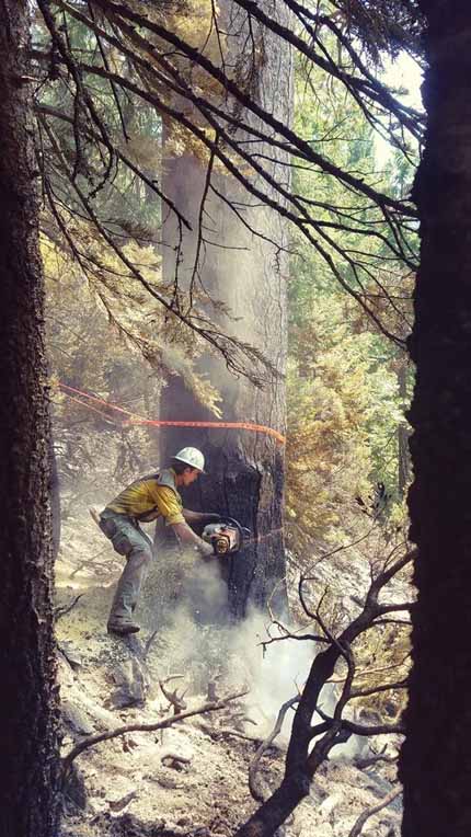
 sawyer Minerva 5 Fire
A sawyer on the Minerva 5 Fire, August 2, 2017. Inciweb photo, uncredited.

Fires in Western Montana still very active

The fires are consuming thousands of acres each day and producing large quantities of smoke.

Above: Satellite photo taken August 1, 2017 showing smoke produced by wildfires in western Montana and Northeastern Idaho. The red dots represent heat detected by a sensor on the satellite.

(Originally published at 10:48 a.m. MDT August 2, 2017)

The residents of Western Montana have been dealing with wildfire smoke for several weeks and there is no relief in sight.

Our map above identifies eight of the largest blazes in the area. Here are a few facts about some of them, with them ranked in priority order according to fire management officials.

  • Rice Ridge: Six miles north of Seeley Lake, MT; 3,994 acres, 150 personnel assigned.
  • Sunrise: Six miles south of Riverbend, 9,900 acres, 548 personnel assigned.
  • Sapphire Complex: Three fires, 15 miles southeast of Clinton, MT, 12,756 acres, 864 personnel assigned.
  • Lolo Peak: 8 miles southwest of Lolo, MT, 5,724 acres, 822 personnel assigned.
  • Arrastra Creek: 6 miles northwest of Lincoln, MT, 3,675 acres, 127 personnel assigned.
  • Whetston Ridge: 25 miles southwest of Philipsburg, MT, 3,621 acres, 30 personnel assigned.

Satellite view of four wildfires in Idaho and Nevada

Above: Smoke from the Roosters Comb Fire was captured in a photo by the (non-operational) GOES-16 satellite at 7:30 p.m. MDT July 10, 2017.

(Originally published at 7:20 a.m. MDT July 11, 2017)

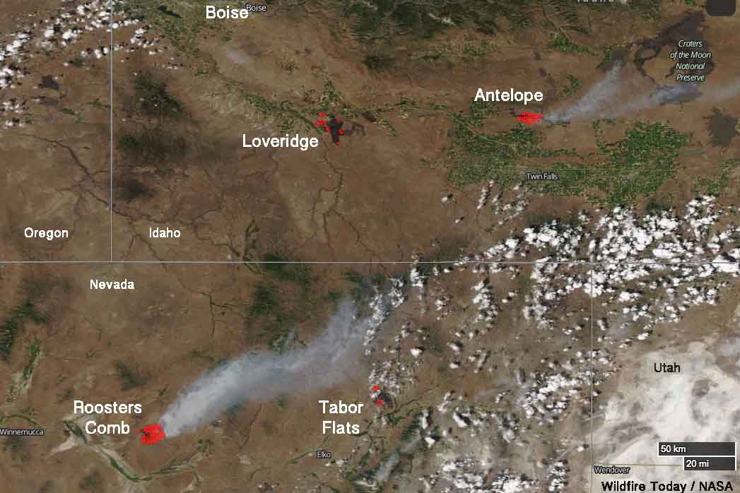
Four wildfires in northeast Nevada and southern Idaho are large enough that satellites are able, in some cases, to see the smoke and the blackened burned areas. These photos were taken late in the afternoon on Monday July 10.

The one putting up the most smoke Monday was the Roosters Comb Fire which as of Monday evening had burned approximately 25,000 acres in Nevada 17 miles northeast of Battle Mountain. It was reported at 9 p.m. Sunday July 9. The fire is spreading rapidly through grass, sagebrush, and pinyon-juniper.

smoke Roosters Comb fire Nevada Idaho
Four wildfires in Nevada and Idaho were photographed by a satellite Monday afternoon, July 10, 2017.

Farther to the east in Nevada is the Tabor Flats Fire 27 miles northeast of Elko close to Interstate 80. The reported size of this fire is also 25,000 acres. The fire behavior in the tall grass is described as “extreme, running, flanking, wind driven runs”.

In Idaho the Loveridge Fire has burned over 38,000 acres 18 miles south of Mountain Home. It was shown as contained in the Tuesday morning national situation report. The heat detected by the satellite in that area (shown as red dots) could either be from the Loveridge Fire or a new fire in the same area.

The Antelope Fire at Shoshone, Idaho just south of Interstate 84 has covered 29,500 acres. It is exhibiting extreme fire behavior with wind-driven runs.

Idaho legislature refuses to close loophole in fireworks regulations

The state of Idaho has a ridiculous law regulating the use of fireworks. It prohibits the use of fireworks that fly more than 20 feet into the air, including bottle rockets and aerial displays, that are used for private purposes. However, they can be sold in the state without any problem. The buyer simply has to promise by signing a form that they will not use them in Idaho.

Yesterday House Minority Leader Rep. Mat Erpelding introduced legislation that would close this loophole, making the sale of the illegal fireworks illegal. However within hours on a vote of 9 to 6 it was shot down by the House State Affairs Committee.

Dennis Doan, Chief of the Boise Fire Department, released a statement on Monday:

I would like to thank Rep Erpelding for his leadership on this issue. It was clear by the actions of the committee today they do not care about firefighter safety, or if people’s homes and lives are being destroyed by illegal fireworks every year. The exorbitant cost to taxpayers and local governments, and the fact that six homes in Ada County were burned down last year, was not enough to influence their decision to print a bill which would allow a full hearing and dialogue about this important issue.

The ability to purchase illegal fireworks apparently trumps the right of residents to protect their home from fires. This summer when someone’s home burns down due to aerial fireworks you can blame the House State Affairs Committee.

The 2,500-acre Table Rock Fire in the Boise foothills last June was caused by illegal fireworks, burned a home, and cost taxpayers $341,000, according to Chief Doan.

Rainfall in western states slows wildfire season in many areas

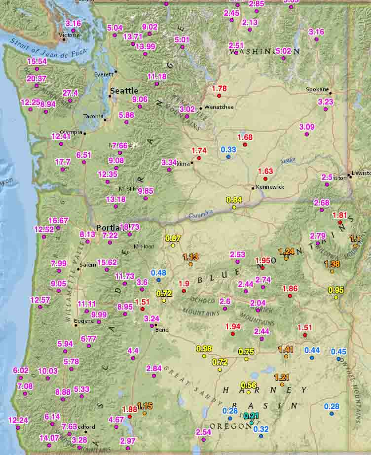
Rainfall last 2 weeks washington oregon
Rainfall last 2 weeks, Washington and Oregon

Rainfall over the last two weeks has slowed or in some cases, ended the wildfire season in some areas.

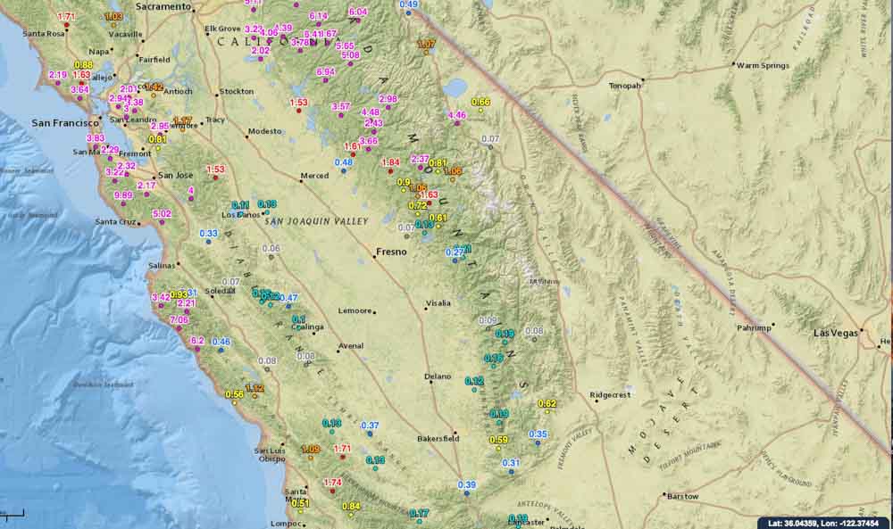
On October 19 we ran the numbers for the accumulated precipitation for the last 14 days in the western states. These maps show amounts that exceeded 0.05 inches at some of the Interagency Remote Automatic Weather Stations (RAWS).

Washington, Oregon, and northern California have received a good soaking and I would imagine that local fire officials may be declaring an end to the fire season. Of course this is not unusual for these areas this time of the year, and some locations had already seen their season end. But what IS unusual, is the high amount of moisture that occurred in just two weeks.

You can click on the images to see larger versions.

Rainfall last 2 weeks, northern California
Rainfall last 2 weeks central California
Rainfall last 2 weeks, central California

Continue to see maps for the other western states.
Continue reading “Rainfall in western states slows wildfire season in many areas”

USFS Regional Fire Director describes the management of the Pioneer Fire

“There simply isn’t any safe place for [firefighters] to work”

Above:  Pioneer Fire August 31, 2016. InciWeb photo.

The Regional Director of Fire and Aviation for the U.S. Forest Service’s Northern Region, Sue Stewart, distributed a three-page document on August 31, 2016 describing the background and status of the Pioneer Fire that as of September 2 has burned 180,000 acres in central Idaho. Below are two excerpts. You can view the full document here.

****

“The Pioneer Fire on the Boise National Forest started on July 18th, and despite our best efforts it escaped our initial attack. Six weeks later, on August 31st, the fire is 157,000 acres and still spreading to the north. There is about 350 miles of fire perimeter, with 182 miles of completed fireline. Here are the things it’s important to understand about our management of this fire:

1. Our initial attack was immediate and aggressive. Here’s the narrative statement that reports our initial response on July 18th:

The Pioneer Fire was reported at 1717 hours to Boise Dispatch by the lead plane assigned to the Casner Fire while it was returning to Boise Airport. The initial fire size-up from the lead plane was 1 to 1.5 acres in continuous fuels. No structures in the immediate area of the fire and poor road access. The fire was initial attacked by one air attack, one lead plane, four helicopters, one heavy air tanker, two single engine air tankers, 11 smoke jumpers, Boise Hotshots, Crew 11, Engine 412, one wet patrol unit, and a fire investigator.

At 1804 hours dispatch received an update that the fire was increasing in size. The first resource on scene was Boise BLM Helitack at 1810 hours. They immediately ordered a heavy air tanker, two single engine air tankers, two type 2 helicopters, and one type 1 helicopter for the fire.  The helitack crew was unable to find a landing site near the fire area. They flew to Idaho City Airstrip to put on a bucket for water drops and returned to the fire.

At 1841 hours dispatch received another update that the fire was five acres, growing, burning in timber, torching, and crowning flame lengths. By 1906 hours the fire was reported between 15 and 20 acres, spotting, with uphill runs. The fire was reported to be 30 acres by air attack at 2004 hours. Later, air attack reported the fire 100 acres with group tree torching at 2127 hours.

At 2207 hours the type 3 incident commander ordered additional resources to the fire. The order included, one additional type 2 helicopter, four type 1 crews, three type 2 IA crews, five type 4 engines, two water tenders and two dozers for the next day.

The cause of the Pioneer Fire is under investigation. The origin of the fire was located on Boise National Forest in Forest Service fire protection at T7N, R6E, section 16.

Reports that heavy air tankers were sitting unordered and unused while the fire was attacked by single engine air tankers are incorrect. We only had access to one of them, the other was on a mandatory day off. (Pilots are required to stand down to rest for safety one day each week during which time critical maintenance is taken care of on those heavily used aircraft.) The initial response was commensurate with the challenges the fire presented at IA, and we launched the heavy air tanker right away.

[…]

9. If we could put this fire out without compromising the safety of our firefighters and aviators we would do so. We will not put people in harm’s way without safety zones in which they can seek refuge from extreme fire behavior, and so as the fire continues to move to the north toward the Deadwood Reservoir and into some more remote terrain our suppression investments will decline significantly commensurate with values at risk from the fire.

In the past week as the fire has moved past locations where we might reasonably and safely check its progress, we have scaled back our workforce. There are just half the numbers of firefighters as there were last week; there simply isn’t any safe place for them to work and so we are able to redirect firefighters to other incidents where they can make a difference. As the Pioneer Fire bumps into old fire scars, however, we have opportunities in the altered fuels to stop its progress and we will be taking advantage of those opportunities. A projected containment date in October is not giving up – it’s simply being realistic about what we can do safely.”