Four wildfires in Reno area have burned about 115,000 acres

Limerick Fire
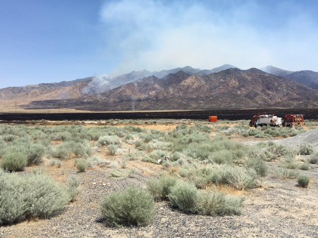
The Limerick Fire, 94 miles northeast of Reno. Photo posted to Inciweb July 5, 2017.

(Originally published at 10:09 a.m. MDT July 6, 2017)

Four large wildfires in the Reno/Sparks, Nevada area have burned a total of about 115,000 acres since the first ones started July 3.  Brook Chadwick’s Type 2 incident management team will be assuming command of the Earthstone, Truckee, and Winnemucca Ranch Fires.
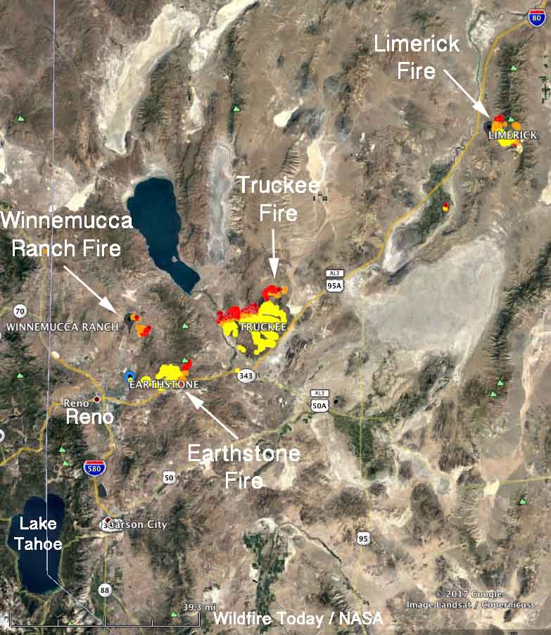
Map four large wildfires Reno, Nevada
Map showing the four large wildfires in the Reno, Nevada Area, July 6, 2017. The red, yellow, and brown dots represent heat detected by a satellite. The red dots are the most recent. Click to enlarge.
wildfires Reno, Nevada area
Four large wildfires in the Reno, Nevada area. NIFC Situation Report July 6, 2017.

Earthstone Fire, 26,785 acres, just northeast of Reno/Sparks.

Information from Inciweb current as of about 8 p.m. MDT July 5, 2017:

“The Sierra Front Type 3 Incident Management Team assumed control of operations [presumably on Wednesday] and brought in additional resources, including two fire engine strike teams, to allow the releasing of some local fire crews to return to their home districts. A Type 2 Incident Management Team remains scheduled to assume command of the incident on Thursday morning.

Three additional fixed wing aircraft, including one Very Large Air Tanker (VLAT), made retardant drops today. Two Super Scooper air craft, requested from Alaska, are still on order and may arrive as early as Friday, bringing the total number of aircraft on the incident to 18.

Currently, there is no immediate threat to structures; however, residents of the Wadsworth area are encouraged to remain vigilant for the possibility of evacuation and complete their preparations as the head of the fire is now about 10 miles west of the town. Impacts to I-80 are expected in the vicinity of the USA Parkway within the next 24 hours.”

Truckee Fire, 70,546 acres, 28 miles northeast of Reno. Not much information is available, but it is exhibiting extreme fire behavior as it burns in brush and short grass in above normal temperatures and single-digit humidities.

Winnemucca Ranch Fire, 3,000 acres 8 miles north-northeast of Reno. Five structures have been destroyed on this fire and another 175 are threatened. Numerous animals and livestock have been evacuated along rural roads. The fire managers identified competition for firefighting resources as a problem.

Limerick Fire, 14,656 acres 94 miles northeast of Reno and 15 miles northeast of Lovelock. Two outbuildings have burned.

Information from Inciweb current as of about 9:40 a.m. MDT July 6, 2017:

“Firefighters stayed on the fire last night and were able to hold the fire line at the ridge to the south of Wright’s Canyon. Snow is still in the higher elevations and greener grass has helped keep the fire on the ridgetop.

Potential fire weather is predicted for the weekend and a structure protection group has been established as a contingency for active fire behavior.

Crews completed burn outs in the southeast corner of the fire yesterday and were able to connect containment lines to the dozer line near Golden Gate Hill. Crews will continue to secure fire line and begin mop up in the area near Couer Rochester Mine. Fire crews will continue to put in containment line on the eastern side of the fire working their way north.

Limerick Road is open to firefighter and mine traffic only.”

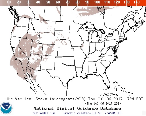
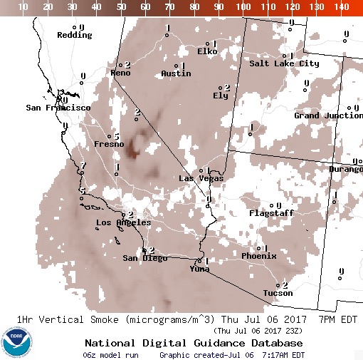
The maps below are forecasts for wildfire smoke at 5 p.m. MDT on Thursday.
wildfire smoke forecast
A forecast for wildfire smoke in the Pacific Southwest at 5 p.m. MDT July 6, 2017.

****

wildfire smoke map
A forecast for wildfire smoke in the United States at 5 p.m. MDT July 6, 2017.

Videos of the first 5 hours of the Fairview Fire in Nevada

Above: Screen grab from the NVSeismoLab video.

The cameras operated by the Nevada Seismological Laboratory detected and recorded the ignition and spread of a wildfire near Fairview Peak south of U.S. 50 between Fallon and Austin in western Nevada. Below we have the time-lapse videos, each compressing about one hour to one minute.

According to KOLOTV the Fairview Fire burned at least 50 acres of Fallon Naval Air Station land.

Below the descriptions (provided by nvseismolab) are the applicable videos.

****

Although the fire starts at 12:50 PM, it begins in earnest around 1 PM … First fire discovery for 2017! Starting to pick up speed by hour’s end.

Although early in the season, the fire still manages to expand and move uphill in plain sight of the Fairview Fire Camera. Time lapse covers from 2 PM to 3 PM.

Fairview Fire continues to grows as air resources begin to drop water on the fire …

4th hour time lapse of the Fairview Fire as more helicopter delivered buckets hit the flames.

This one hour long time lapse video starting at 8 PM shows continued wildfire activity. Near-IR filter is turned on 42 seconds (8:42 PM) …

Report released on fatal BLM engine rollover

BLM Unimog Engine 2410 when it was new in 2006. BLM photo.

The Bureau of Land Management has released an Accident Investigation Factual Report for the July 10, 2016 engine rollover north of Winnemucca, Nevada in which two firefighters were killed and a third was seriously injured.

Jacob O’Malley and Will Hawkins lost their lives in the single-vehicle accident on Nevada State Route 140 when a rear tire suddenly and catastrophically failed. The truck only had four tires, there were no duals on the rear. When the right-rear rim dragged along the pavement the left-front was in the air, eliminating any possibility of control by the driver. The 33,000 pound GVWR engine fishtailed and then rolled several times.

The cab was higher than the water tanks and pump package, so it took the majority of the impact as the top of the vehicle struck the roadway during the rollover. All three occupants were wearing seat belts but with the top of the cab and the A pillar being damaged or sheared off, the restraint system failed to operate as designed. Mr. Hawkins was ejected from the cab and then was hit by the rolling wreckage.

Below is an excerpt from the report:

Finding 3.1 (Material): During the rollover, the upper cab structure (made of reinforced carbon fiber) sheared away from the truck frame, exposing the vehicle’s occupants to a hazardous environment. The disintegration of the cab compromised the driver’s and right side passenger’s seatbelt systems.

Discussion 3.1: The lack of cab crashworthiness did not cause the rollover; however, it contributed to the fatal conditions which occurred during the crash. The reinforced carbon fiber cab on the Unimog was manufactured in France and was built to United Nations Code ECE r29 (commercial vehicle occupant protection), which exceeds U.S. cab crashworthiness standards. The U.S. National Highway Traffic Safety Administration (NHTSA) submitted a report to Congress in 2015 on the need for improved heavy truck crashworthiness standards; however, no action has been taken on this report as of February 2017.

There are 41 articles on Wildfire Today about the rollovers of wildland fire apparatus.

We still stand behind what we wrote in a 2015 article about the many firefighter fatalities from rollovers:

The wildland fire agencies should fund research conducted by engineers to determine how to prevent the passenger compartments in their fire engines from collapsing in accidents.

Thanks and a tip of the hat go out to Eric.
Typos or errors, report them HERE.

“Vegetation” involved in fire on roof of Las Vegas hotel

A fire on the roof of the Bellagio Hotel in Las Vegas created quite a show for people who came to watch the fancy water fountain display Thursday night. The Las Vegas Review-Journal wrote that styrofoam facades burned, but it appears that real or fake vegetation on the roof may have also been involved.

Firefighters were able to knock down the wind-driven fire about 25 minutes after it was first reported.

At least there was a wet line on one flank of the fire:

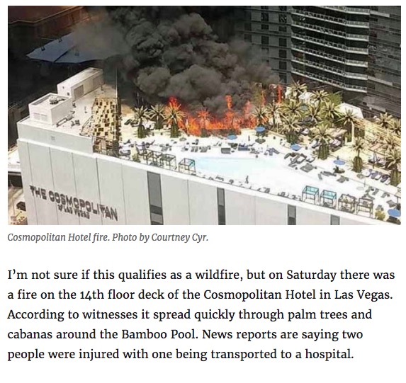
This reminds us of a similar fire on another hotel roof in Vegas in 2015. Here is a screenshot of part of that article:

Cosmopolitan Hotel Fire egas, 2015
Cosmopolitan Hotel Fire, Las Vegas, 2015.

Two reports released on the same day about the escaped prescribed fire near Carson City, NV

Above: Map of the Little Valley Fire at 9:23 p.m. PDT October 14, 2016.

On February 15 two reports were released about the prescribed fire that escaped, burned 2,291 acres, and destroyed 23 homes northwest of Carson City, Nevada on October 14, 2016. The first report about what became the Little Valley Fire included the results of a months-long independent investigation by the Reno Gazette-Journal (RGJ). The other, released a few hours later, was the product of the official investigation requested by the Nevada Division of Forestry (NDF), the agency responsible for conducting the prescribed fire.

Hours before the fire escaped, all eleven firefighters that had been mopping up the prescribed fire left the project and returned to their stations between 1:30 p.m. and 4:45 p.m. on October 13, 2016. During that day there were a number of smokes that received the attention of the firefighters. During the last two hours before the seven-person helitack crew departed they noticed the wind increasing — trees were blowing down and branches were falling.

The RGJ reported on the reason the firefighters were ordered to leave the burn site.

Gene Phillips, NDF forest health specialist and burn boss for the Little Valley Burn, made the decision to pull crews from the burn site after discussing the high wind forecasts for the evening with a burn boss trainee, according to the review.

The decision not to staff the site on the evening of Oct. 13 was made, according to NDF, “based on the limited amount of heat near the control lines, success of the current mop-up effort, and the risk to firefighters working in timber during high winds.”

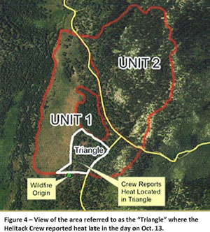
escaped fire map
From the NIMO report.

At 5:38 p.m. the Little Valley weather station recorded sustained winds out of the west at 15 mph with a maximum gust of 39 mph. By 12:38 a.m. on October 14, about the time the fire escaped, the wind was at 19 mph with gusts up to 87 mph. The relative humidity was 32 percent.

A Red Flag Warning for gusty winds and low humidity was in effect from the morning of October 11 through 5 p.m. on October 14. Strong winds persisted until mid-day on October 17.

The NDF’s report was written by the U.S. Forest Service’s Phoenix National Incident Management Organization (NIMO), a team that usually manages fires and other incidents that are often of longer duration than a typical wildfire. The team was supplemented with a Fire Behavior Analyst, a GIS/Fire Behavior Analyst, a Public Information Officer, a Fire Investigator, and others for a total of 10 personnel that were listed in the report.

The NIMO team concluded that the fire escaped when embers from a burning stump hole were blown 34 feet and crossed the fireline at a corner, or “dog leg” in the fire perimeter.

According to the RGJ there was confusion in initially responding to the fire after it escaped at around 12:38 a.m. on October 14:

Response to the fire was delayed, affecting how fast it could be contained: A call at 1:23 a.m. about smoke at the burn site was later dismissed as “unfounded,” causing a TMFPD [Truckee Meadows Fire Protection District] fire engine to return to the station three minutes after it left. After a second call about smoke at the burn site, it took TMFPD more than an hour to get to the site after crews were dispatched, according to 911 transcripts.

Rainfall in western states slows wildfire season in many areas

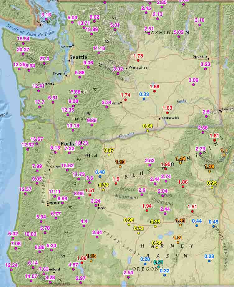
Rainfall last 2 weeks washington oregon
Rainfall last 2 weeks, Washington and Oregon

Rainfall over the last two weeks has slowed or in some cases, ended the wildfire season in some areas.

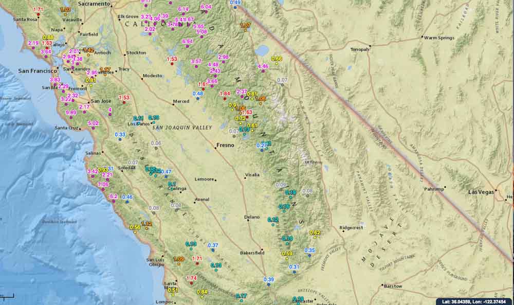
On October 19 we ran the numbers for the accumulated precipitation for the last 14 days in the western states. These maps show amounts that exceeded 0.05 inches at some of the Interagency Remote Automatic Weather Stations (RAWS).

Washington, Oregon, and northern California have received a good soaking and I would imagine that local fire officials may be declaring an end to the fire season. Of course this is not unusual for these areas this time of the year, and some locations had already seen their season end. But what IS unusual, is the high amount of moisture that occurred in just two weeks.

You can click on the images to see larger versions.

Rainfall last 2 weeks, northern California
Rainfall last 2 weeks central California
Rainfall last 2 weeks, central California

Continue to see maps for the other western states.
Continue reading “Rainfall in western states slows wildfire season in many areas”