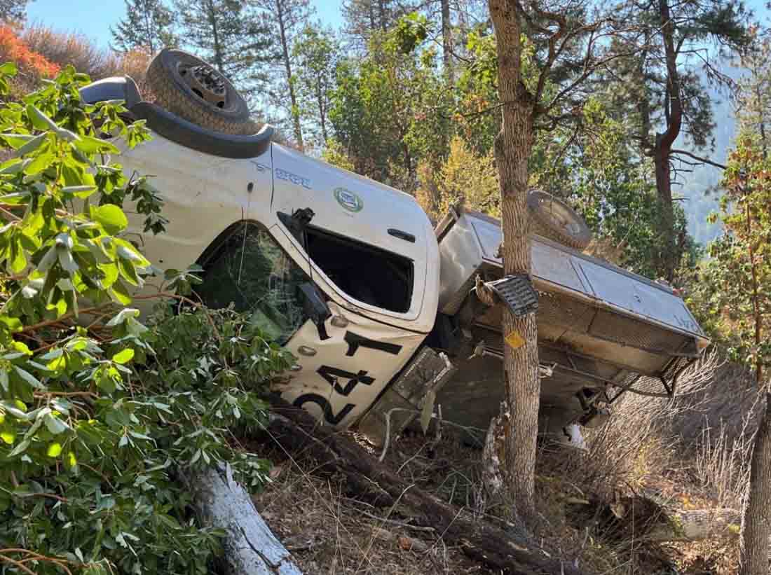
Engine rollover on Anderson Butte Fire. Photo from the Wildland Fire Lessons Learned Center report.
On October 2 one of three responding Type 6 engines rolled over while responding to the Anderson Butte Fire in Oregon. On the gravel road much dust was being kicked up compromising the visibility of the drivers. They were heading into the sun and the driver of the rollover engine said he was relying on the emergency lightbars of the engines ahead of him to find his way.
As he rounded a shaded corner, the sun hit the engine windshield and severely impacted his vision. He did not notice the curve in the road. Soon after, the Engine 241 driver—who was the vehicle’s sole occupant—noticed that the passenger side front tire was no longer contacting the ground. He attempted to steer back toward the road, but momentum caused the engine to tip. The engine then rolled more than two times before being stopped by a small grove of oak trees, finally coming to rest on the driver’s side, approximately 100 feet below the road.
The driver was able to climb out through the passenger window, walk up to the road, and radio for help.
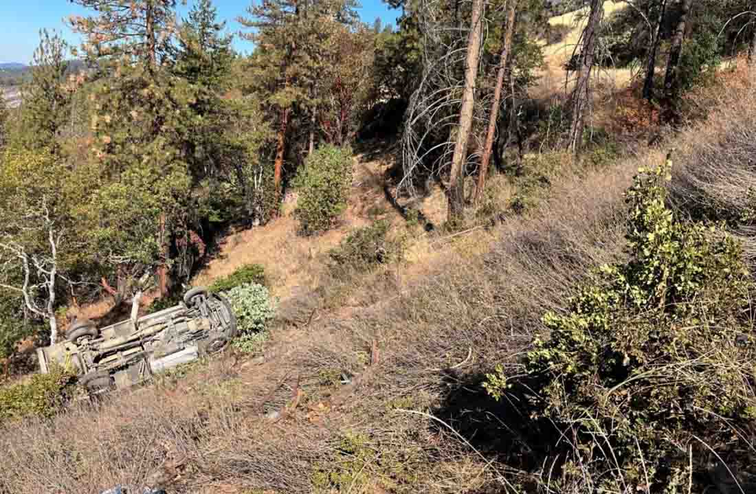
Engine rollover on Anderson Butte Fire. Photo from the Wildland Fire Lessons Learned Center report.
The driver indicated that he basically just had a laceration on his leg. He initially requested to continue to the fire, but was held back for further evaluation. A local ambulance crew arrived around 30 minutes later. The driver was evaluated for head trauma and his lacerated leg was treated. The ambulance was released, the driver was instructed to return to his home unit, and was driven there by his supervisor.
The engine, which was totaled beyond repair, was retrieved by a wrecker the following day.
Two of the lessons pointed out in the report were:
Continuously evaluate conditions, as dust and sun angle make for less visibility, travel at slower speeds, and allow for more space in between yourself and the vehicle in front of you.
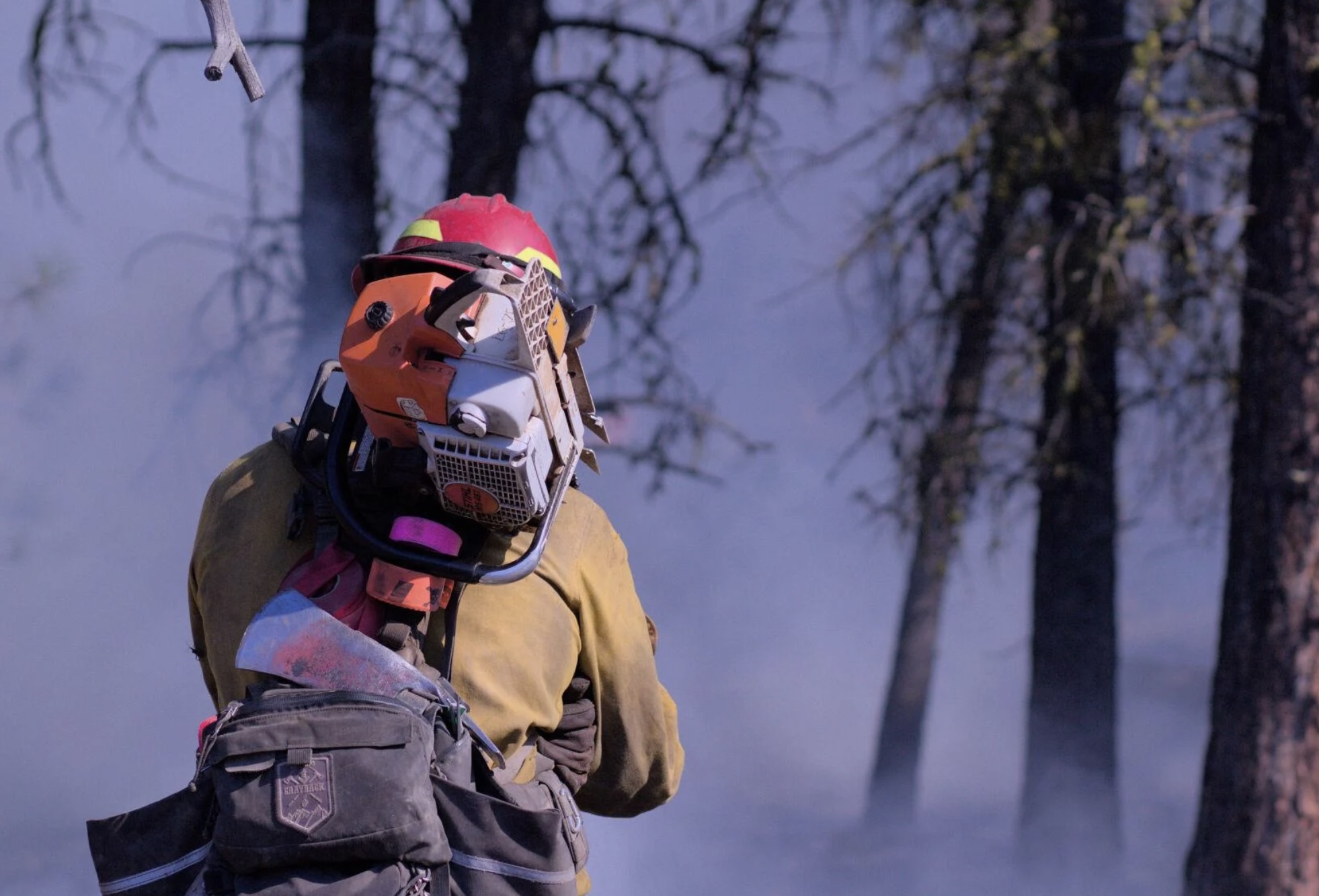
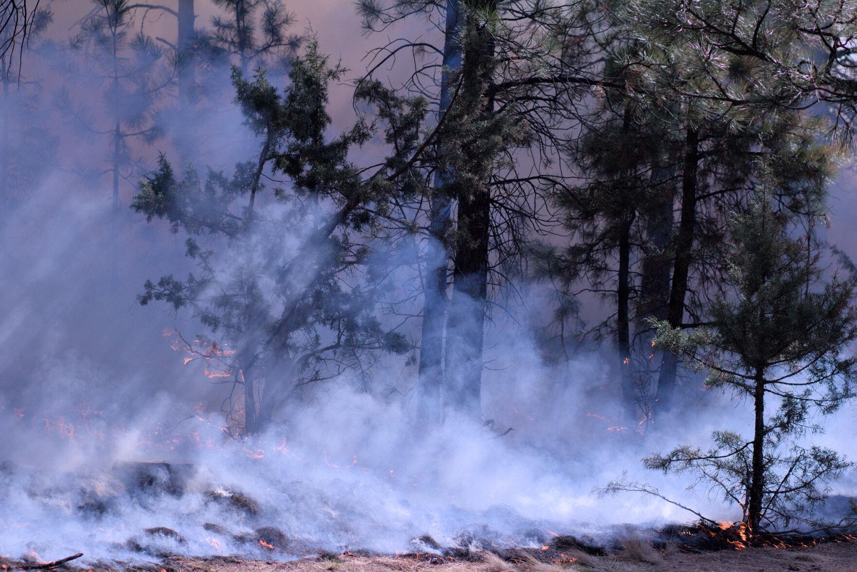
A Grayback employee at the Starr 6 prescribed fire, Oct. 19, 2022. Tony Chiotti – Blue Mountain Eagle.
Editor's note
This article was written by Blue Mountain Eagle reporter Tony Chiotti who was on the scene of the Starr 6 prescribed on the Malheur National Forest in Oregon before it jumped containment and spread to private land on Oct. 19. In reporting this story, he drew on observations made that day as well as multiple interviews with Forest Service officials, burn crew workers, and landowners. It is used here with permission.
When Rick Snodgrass approached Grant County Sheriff Todd McKinley, he thought the sheriff was there to help him.
According to Snodgrass, he’d called for law enforcement to help control aggressive traffic and to deal with harassment his crews had been receiving while implementing a prescribed burn on the Malheur National Forest in Bear Valley, about 7 miles north of Seneca.
That burn — called the Starr 6 — had since jumped the fireline, and now there was active fire on both sides of County Road 63, where Snodgrass and McKinley met: the prescribed burn operation on Malheur National Forest land to the north of the road — now flaring up in gusts of wind — and an uncontained slopover on private land to the south. The crews under Snodgrass’ direction were now attempting to quell one fire while holding the reins on another, with tempers, smoke, wind and now traffic adding to the dangers to his crew.
But instead of assistance, what Snodgrass got was arrested.
When the sheriff cuffed Snodgrass, it is thought to be the first time a U.S. Forest Service firefighter has been arrested in the course of performing their job.
Snodgrass, the “burn boss” on the day’s operation, was taken away from the scene and charged with reckless burning, a Class A misdemeanor that carries a maximum penalty of a year in jail and a $6,250 fine. Before it was contained, an hour after it kicked off, the spot fire burned an estimated 20 to 40 acres of private land owned by members of the Holliday family.
The arrest of Snodgrass on Wednesday, Oct. 19, has drawn national attention and has fanned the debate over Forest Service fire mitigation policies, especially as they pertain to intentional burns adjacent to private lands.
And in the aftermath of this burn, there are accusations on both sides of this contentious debate about which actions on that day deserve the blame. Critics of the Forest Service and the affected landowners feel the conditions on the day never should have allowed the burn to proceed. Others, including Forest Service personnel who planned and executed the burn, say that by arresting the burn boss at the moment of maximum danger, the planned operation and the safety of the crews were placed in jeopardy.
“Other individuals were able to pick up the slack, fortunately, that were well trained,” Snodgrass said. “He put not only my guys at risk out there, their safety, but he put that land at risk as well as, you know, all of Bear Valley.”
The buildup
In 2015 the Canyon Creek Fire, which started with lightning strikes on Malheur National Forest land and spread to private ground, ultimately burned over 110,000 acres and destroyed 43 structures in Grant County.
There is general agreement that a hundred years of fire suppression has led to forests that are overfilled with fuel, a situation made more dangerous by a prolonged drought. Part of Canyon Creek’s legacy is the strongly held and polarized views on how to best prevent catastrophic fires in the future.
Proponents of prescribed burning see the scorched canyons along US 395 as a reminder of the stakes, the need to create buffers, remove built-up fuels and restore forests to a pre-suppression state where they can better survive the inevitable blaze, while critics of federal land management and the Forest Service see a constant reminder of botched containment efforts and mismanaged public land that only fuel their distrust.
“Every individual has a different opinion and motivation,” said Craig Trulock, supervisor of the 1.7 million-acre Malheur National Forest. “You have people that are just anti-federal and don’t want any federal agency doing anything that could affect their lands. Others don’t like prescribed burning for various reasons, whether it’s risk or a sense that it doesn’t achieve what we should be doing out there because they want every log to go on a log truck. And then you have people that are saying, ‘When you burn, would you please burn my property as well?’”
According to Trulock, the burn had been going to plan. “We were within prescription on the burn,” Trulock said, noting he couldn’t say much more as the incident is now the subject of an active federal and local investigation.
Firefighter at the Starr 6 prescribed fire, Oct. 19, 2022. Tony Chiotti – Blue Mountain Eagle.
The fire was the second day of prescribed burning in as many weeks. The burn area planned for Wednesday, Oct. 19, was 300 acres, including trees and meadowland within the Malheur National Forest in an operation involving federal, state and contract firefighting crews, according to information from the Forest Service.
This was among the first prescribed burns to be allowed after a new set of restrictions came into effect this year, following high-profile cases of prescribed burns getting out of control on federal land and causing massive damage, including the Calf Canyon/Hermit’s Peak blaze in New Mexico, which burned several hundred thousand acres and hundreds of structures this spring. After a 90-day pause on all prescribed burns, a revised set of restrictions was published.
As part of those new rules, before ignitions could begin in Bear Valley, a go/no-go checklist had to be completed on site.
This day’s final check represented the end of a multiyear process. That process involved an environmental analysis of the project area that included commercial logging, noncommercial thinning and burning treatments. The burn plan takes the form of a 100-plus-page document, updated year over year as the preparatory steps of thinning, fuel removal and tree grinding continued, all to get the area into ideal shape for a burn.
As part of the new rules, the final ignition authorization had to be signed by four people: the agency administrator, local unit line officer, burn boss, and fire management officer or duty officer. This process only authorizes ignitions for 24 hours, in effect giving all four officers veto power over the burn based on that day’s conditions.
On this day, all four individuals assessed the conditions, and all four signatures were affixed to the burn authorization, meaning ignitions could begin. One of those four signatures belonged to Rick Snodgrass.
Smoldering tensions
The ignition was delayed for about 45 minutes while crews did a grid search to ensure there were no cows in the burn area after hearing reports that the Hollidays still had some “stragglers” left on national forest land, a common occurrence as cows are seasonally moved off grazing allotments. The Windy Point Ranch allotment specified an Oct. 15 “off date,” but Chad Holliday explained that some fence that was burned the previous week, along with gates being left open by fire personnel, meant he couldn’t be sure the cattle were all out.
Initially, the burn went according to plan, with light winds of 0-3 mph and the heat of the fire drawing smoke up into a clean, bent column over the county road. The fire moved slowly across 50 acres over the course of five hours, with fire crews monitoring the progress of its leading front and continuing drip-torch ignitions.
Ignitions paused in the afternoon, to begin again a couple hours later. It was then that the wind picked up and a few trees in the interior of the already-burned area torched, sending up “duffers” with the smoke, up and over the road.
Members of the Holliday family, who own the Windy Point Ranch and other land adjacent to the burn area, were standing across the county road from the fire as an ember from the burn area touched town on their ranch, starting a new fire that soon began to spread.
“We were glad to see Oregon Department of Forestry and Grayback (contract crews) show up,” said Mandy Taylor, Chad Holliday’s sister.
ODF and Grayback Forestry crews were contracted to work alongside Forest Service employees throughout the day’s burn, but due to tensions between the landowners and the federal crews, they were eventually asked to take over mop-up after the flames of the spot fire were extinguished, according to Trulock, who said the move was meant to calm tensions on the scene.
Those kinds of tensions are not unusual.
“I think in a lot of parts of Oregon, it’s just a very real experience for federal employees to have a lot of hostility towards what they’re doing right now,” said Christopher Adlam, a regional fire specialist for Oregon State University’s Extension Service. “I’m not saying that people don’t also appreciate firefighters and thank firefighters. But it’s a pretty common thing in some parts of Oregon for federal employees to face hostility.”
Indeed, federal crews called the regional interagency dispatch center on both days of the burn to report verbal harassment, threats and aggressive driving through the smoke, and to request law enforcement assistance on the scene.
The Hollidays maintain they were welcoming and cooperative with federal crews, providing access to their land in order to contain the blaze. But as the fire spread and crews worked to contain it, the Hollidays called 911. They didn’t call to report the fire. They asked for the sheriff. “We knew that somebody was doing something wrong,” said Taylor.
Planning for contingencies
If you use the phrase “controlled burn” in the vicinity of firefighters operating a prescribed burn, you will be corrected.
This is fire. You don’t control it. The best you can plan for is to manage it and be prepared if the fire has other ideas.
Adlam points out that spillover fires like the one that happened in Bear Valley are rare occurrences but can still have a huge impact on people. “I think that, the last 20 years, we’ve had one other occurrence of a burn crossing over from federal land onto private land in Oregon,” he said.
The Malheur National Forest supervisor notes that the spillover was quickly brought under control.
“They caught it with the resources they had on scene,” said Trulock. He noted that the number of crew on scene before the fire jumped was far more than their own burn plan had recommended, and that the new rules and added caution likely led to their ability to ultimately contain the spot. “We didn’t use any aviation or anything. The only additional resource we brought on was that dozer, and that was to really secure the edge of the spot so that they could then mop it up. So we were staffed enough to actually catch something like this.”
The Grant County Sheriff’s Office and the Forest Service estimated the size of the spot fire as approximately 20 acres. Chad Holliday estimates it as closer to 40, after measuring the perimeter of the area at “exactly one mile.”
“Somebody’s got to be held accountable”
As the federal crews were attempting to control the spot fire on the ranch, McKinley arrived. Chad Holliday received a call from his sister, who was on the scene and told him to get home. He arrived to see Sheriff McKinley speaking with people along the fence.
“I walked up, and Todd said, ‘Chad, right now you’re (being) videorecorded. You’re the spokesman for the ranch. Would you like to press charges?’ And I said, ‘Absolutely. Somebody’s got to be held accountable.’”
Holliday said McKinley then went directly to Snodgrass on the county road and “put the cuffs on him.”
The Eagle has filed a public records request for bodycam footage or any other video taken at the scene during this incident by the Grant County Sheriff’s Office. The newspaper is also seeking any other video footage captured at the scene that could further help establish the sequence of events.
The Starr 6 prescribed fire, Oct. 19, 2022. Tony Chiotti – Blue Mountain Eagle.
“A reasonable person”
The fire was set in the days before predicted rain, and will likely prove to be the last of this year’s short burn season. But the issues surrounding prescribed burning and federal land management, especially as it impacts private landowners, will undoubtedly remain a flashpoint in Grant County.
For now, as the investigation continues, McKinley is playing things close to the vest. He’s declined offers to comment on the case beyond his initial press release, which said “details cannot be released at this time.”
Grant County District Attorney Jim Carpenter has been slightly more forthcoming, stating in his own press release that just because the burn boss was working as part of a federal crew doesn’t mean he will be shielded from potential legal consequences.
“To be clear, the employer and/or position of Snodgrass will not protect him if it is determined that he acted recklessly,” he wrote. “That the USFS was engaging in a prescribed burn may actually raise, rather than lower, the standard to which Snodgrass will be held.”
Carpenter lays out in his release the full legal standard for determining if a burn is or is not “reckless” as defined in Oregon statute: “The risk must be of such nature and degree that disregard thereof constitutes a gross deviation from the standard of care that a reasonable person would observe in the situation.”
McKinley, known as a level head in the wider context of Grant County politics, might not have intended to make a statement. But this extraordinary arrest has caught national attention and sparked debate in the press and online. And now in the actions of the sheriff and the actions of the Forest Service, both sides see actions that created real danger.
Critics of the Forest Service point to the simple fact that the fire escaped the lines as evidence the conditions were unsafe and that the fire should never have been approved. To the Hollidays, and those skeptical of federal land management in general, it’s a clear measure: the fire got onto their land and threatened or destroyed their property. How could that have been a reasonable thing to do?
It has also stirred the ire of wildland firefighter communities, who fear this development will set a precedent and only complicate an already difficult and dangerous job. And in these groups’ online conversations, it is clear many believe that the arrest created a situation on the ground that may have added to the real risk faced by fire crews in Bear Valley.
“One of the huge watch-out situations in any fire operation is a transition in leadership,” said Trulock. “And that’s when it’s a plan to transition in leadership. This was obviously unplanned. What I would say is there were definite heightened risks because of that action. Until leadership can be reestablished under a new person, then everybody is distracted because they know something happened. And so it created a huge distraction in the middle of what I would consider is a relatively high-risk operation.”
Adlam, the Extension Service fire specialist, agreed.
“The burn boss’s role is never more important than at the moment where something happens that is not part of the plan,” he said. “If you cut off the head of an operation before it’s finished, how is that supposed to be leading to a positive outcome?”
When reached for comment on this story, McKinley clarified why he’s reluctant to say too much at this point.
He said he knows how it appears in the court of public opinion to withhold detail, but added that as long as it protects the process he just doesn’t care. “I just want to respect the case and not get too much detail out so that it doesn’t mess with potential jury pools and all that,” he said, “because then we’d have to have (the trial) out of the area.”
For McKinley, the important thing is that the facts surrounding this case and the decisions of Rick Snodgrass are ultimately determined by 12 reasonable people — ideally, reasonable people from Grant County.
Late Friday afternoon Chief of the Forest Service Randy Moore sent an email to all Forest Service employees regarding the Wednesday October 19 arrest of a Burn Boss while conducting a prescribed fire that slopped over the Forest boundary, burning approximately 18 acres of private land.
“This week, there was an incident in the Pacific Northwest Region where a Forest Service Burn Boss was arrested while leading a prescribed fire that crossed over onto private lands,” the email read in part. “They were engaging in appropriate, coordinated, and vital prescribed fire work alongside state and other colleagues approved and supported by the Agency Administrator. In my opinion, this arrest was highly inappropriate under these circumstances, and I will not stand idly by without fully defending the Burn Boss and all employees carrying out their official duties as federal employees.
“This employee should not have been singled out, and we are working to address these unfortunate circumstances on their behalf,” Chief Moore continued. “This also prompted me to want to reach out to all of you and remind you of how important you are to the success of the Forest Service. You will always have my support and the same from your regional and local leadership. I will aggressively engage to ensure our important work across the country is allowed to move forward unhampered as you carry out duties in your official capacity.”
The arrest of the Forest Service Burn Boss while conducting a prescribed fire has been picked up by numerous news organizations, including Washington Post, Guardian, NBC News, ABC news, and Reuters.
To our knowledge this is the first time a federal government firefighter has been arrested at a fire for conducting their assigned duties.
Updated at 12:20 p.m. PDT Oct. 21, 2022
Friday morning the Regional Forester of the Forest Service’s Pacific Northwest Region, Glenn Casamassa, sent the following email message to all USFS employees in the Region. (We removed the email addresses)
From: Casamassa, Glenn -FS
Sent: Friday, October 21, 2022 11:07 AM
To: FS-pdl R6 ALL EMPS All Regional Emps
Subject: Support for Malheur Starr Prescribed Burn Boss and crew
To all Region 6 employees,
Many of you have probably seen the news and social media coverage about one of our employees arrested for leading a prescribed fire that slopped over onto private lands. There’s a lot of context and additional information about this incident that would be inappropriate to share publicly at this time, but none of that information revolves around the work conducted during the prescribed burn, the professionalism of our employees, partners, and contractors, or how the burn sloped over onto private land.
While I can’t go into specifics around the arrest of the burn boss, I want each of you to know that all times he, and the entire team that engaged on the Starr prescribed fire, had, and continues to have, our full support.
Communication and coordination between all levels of the Forest Service and the department were effectively in place within hours of this incident. This included local, regional, and national level leadership, Fire and Aviation Management leaders, legal counsel, and law enforcement – which reflects our commitment to this important work and our promise to share in the accountability for any and all outcomes.
I spoke with the Burn Boss last night and expressed my support for him and the actions he took in leading the prescribed burn. In addition, I let him know it’s my expectation that the Forest Service will continue to support him throughout any legal actions.
No one person or crew is in this work on their own. I need you to know that I am with you now and into the future, whatever that future may look like.
I trust and respect our firefighters and employees who carry out the complex and dynamic mission of applying fire treatments to the landscape. They are well-trained, well-informed, and well-equipped for the mission.
Prescribed fire is critical to our responsibility to improve the health of our natural landscapes and the safety of our communities, and we are committed to continuing this work together. Thank you all for staying the course.
Updated 11:50 a.m. PDT Oct. 21, 2022
Grant County District Attorney Jim Carpenter identified the US Forest Service Fire Boss arrested as Rick Snodgrass after the Star 6 prescribed fire burned an unintended 18 to 20 acres of private land near the Malheur National Forest in Oregon.
“This case will be evaluated once the investigation is complete, and if appropriate, Snodgrass will formally be charged,” said Mr. Carpenter in a written statement. “These cases rarely have a bright line and involve a number of variables to be considered. However, to be clear, the employer and/or position of Snodgrass will not protect him if it is determined that he acted recklessly. That the USFS was engaging in a prescribed burn may actually raise, rather than lower the standard to which Snodgrass will be held.”
Updated 8 p.m. PDT Oct. 20, 2022
Grant County Sheriff Todd McKinley told Wildfire Today that when the Malheur National Forest’s Star 6 prescribed fire escaped control and spread onto the privately owned Holliday Ranch the ranch employees “were actually out helping them try to catch the fire and prevent it from doing more damage”, but at the same time some of them were “highly upset.”
Sheriff McKinley said the US Forest Service Burn Boss who was arrested and charged with Reckless Burning did not have to post bail, but met the criteria for “conditional release.” The Sheriff said Forest Supervisor Craig Trulock was at the Sheriff’s Office.
We asked the Sheriff about the report that the arrest was made to de-escalate a tense situation going on with armed private landowners.
“They may have been armed,” he said, “but we are not aware of that. There were definitely some landowners that were highly upset.”
“Determining the rest, honestly, Bill, is getting to the bottom of why they were even burning to begin with and why they chose to burn at that time,” the Sheriff said when we asked about the next step. “You know, there’s a lot more to this. Everybody knew it was a bad burn, should not be happening. Even the fire staff out there, there are fire personnel that were on scene that are afraid to say much because, you know, their jobs. It was not the right time to burn and there may have even been means taken to get that burn done that were outside the scope. That’s kind of where it’s at. You know, it’s a really tenuous situation and more details will come out.”
“The Forest Service employee referenced in the recent reporting was conducting an approved prescribed fire operation on the Malheur National Forest,” the Public Affairs Officer for the Forest, Mary Hamisevicz, wrote in a text message. “It would be inappropriate for us to provide further comment as this is a legal matter.”
The weather recorded at the EW3547 Seneca weather station at 2 p.m. on October 19 was 73 degrees, 16 percent relative humidity, and mostly calm winds that occasionally gusted to 3 mph.
Originally published at 12:19 p.m. PDT October 20, 2022
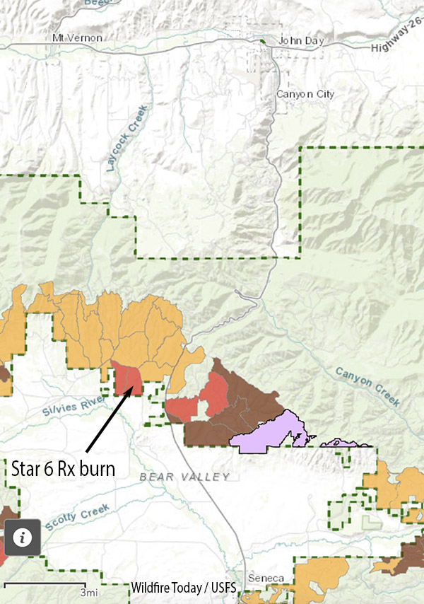
Map, location of Star 6 prescribed fire.
A US Forest Service employee serving as the Burn Boss on a prescribed fire was arrested Wednesday October 19 after the fire escaped and burned approximately 18 acres of private land.
The project was on the Malheur National Forest at mile post two on the Izee Highway between John Day and Seneca, Oregon.
Grant County Sheriff Todd McKinley issued a statement Thursday saying the escaped fire burned lands belonging to the Holliday Ranches on the “hot afternoon of October 19, 2022.”
The statement read in part:
The Grant County Sheriff’s Office arrested a 39-year-old Forest Service employee for Reckless Burning, and transported him to the Grant County Jail. The employee was assigned as the fire’s “burn boss.”
The Sheriff’s office said they are working with the Forest Service to determine the events that led to the escaped fire.
The Star 6 prescribed fire was intended to burn 362 acres. The US Forest Service said on Twitter the escape was caught within an hour at 18 acres, but failed to mention that the Burn Boss was arrested. The Sheriff said it burned approximately 20 acres.
Phone calls to Forest Supervisor Craig Trulock and Blue Mountain District Ranger Sally Christenson were not immediately returned.
This is the first time to this author’s knowledge that a Federal Burn Boss has been arrested for an escaped prescribed fire.
After the 2001 Thirtymile Fire, a Crew Boss was charged with 11 felonies related to the entrapment and burnover deaths of four firefighters who were on his hand crew. He was facing the possibility of decades in prison, but the Assistant U. S. Attorney, perhaps realizing he did not have a winnable case, allowed him to plead guilty to two misdemeanors of making a false statement in an Administrative hearing. Seven years after the fire, he was sentenced to three months of incarceration in a work-release program and three years of probation.
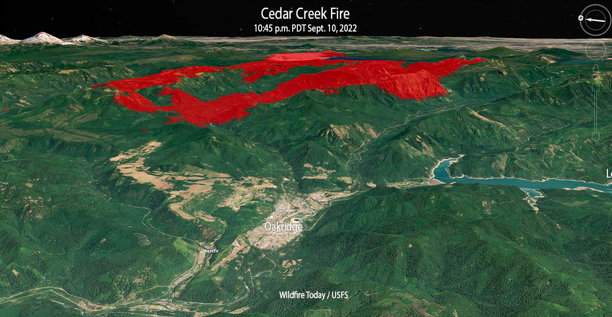
Cedar Creek Fire 3-D map looking east at 10:45 p.m. Sept 10, 2022.
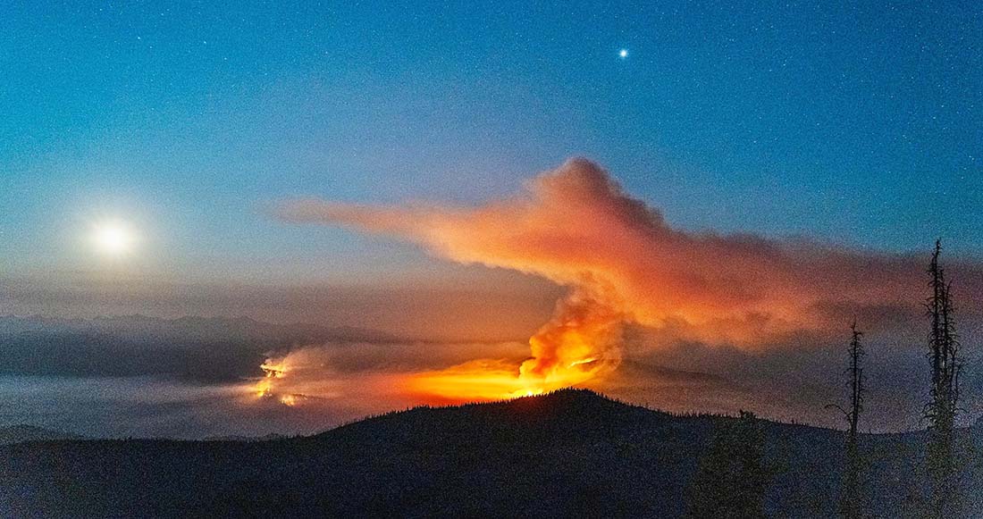
The Cedar Creek Fire that started August 1 in west-central Oregon was already very large at 27,512 acres on the morning of Thursday September 8. But as a result of dry, windy weather on the following two days when a mapping aircraft was over the fire at 10 p.m. Saturday it had more than tripled in size to 85,900 acres. That night the blaze was about 5 miles northeast of Oakridge.
Most of the growth was to the west, driven by strong easterly winds and dry fuels. Saturday evening while winds were from the west, firefighters on the western flank completed strategic burning operations near Eagle Butte, 5 miles northeast of Oakridge. The fire remained north of Highway 58, south of Forest Road 19, and east of Eagle Butte.
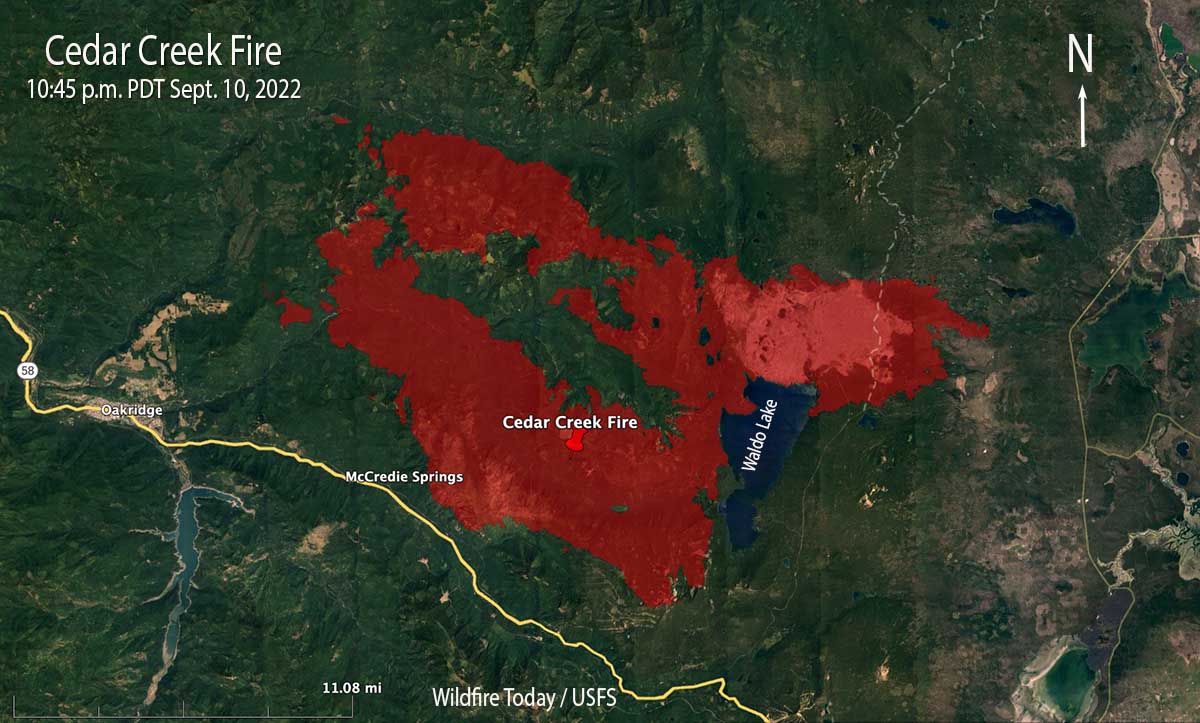
Cedar Creek Fire map, 10:45 p.m. Sept 10, 2022.
The incident management team says 2,230 homes and 443 commercial structures remain threatened, but none have been reported as destroyed. The Office of the Oregon State Fire Marshal has committed seven task forces and an incident management team to the incident.
Saturday evening resources committed to the fire included 17 hand crews, 53 engines, and 8 helicopters for a total of 994 personnel. The estimated suppression costs so far are $47 million.
In the satellite photo below the Cedar Fire is producing the smoke seen in the lower portion of the image.
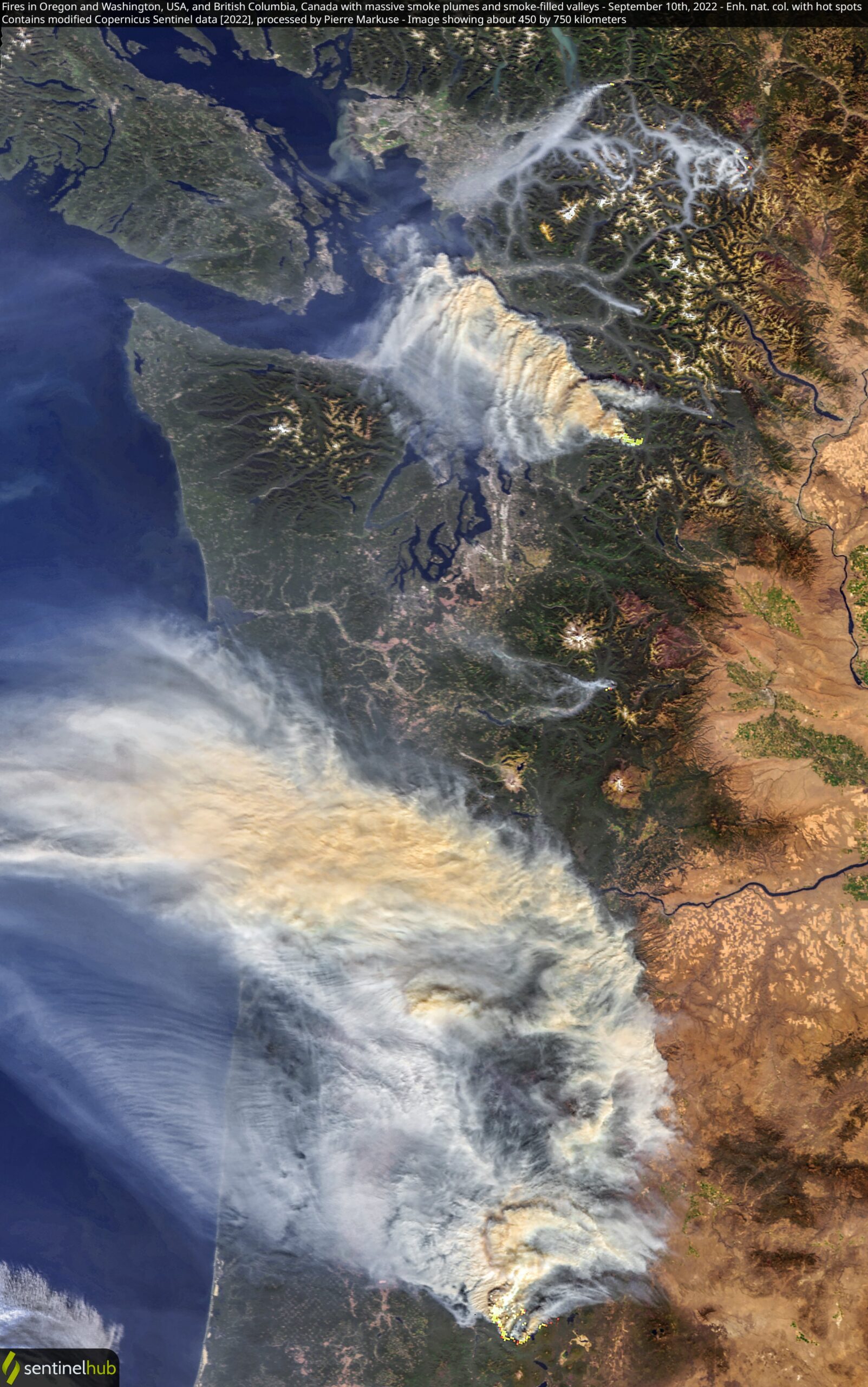
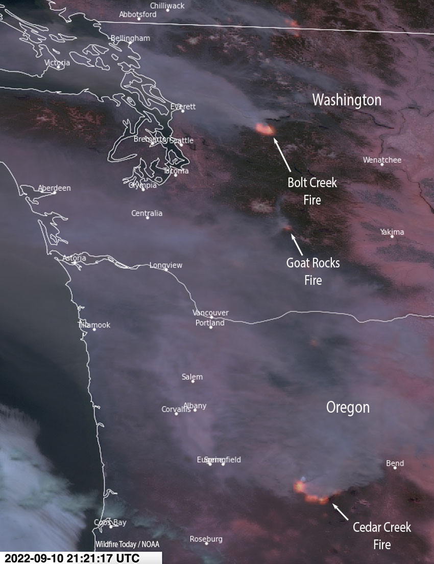
Satellite photo, Bolt Creek and Cedar Creek fires Sept. 10, 2022. Processed by Pierre Markuse.
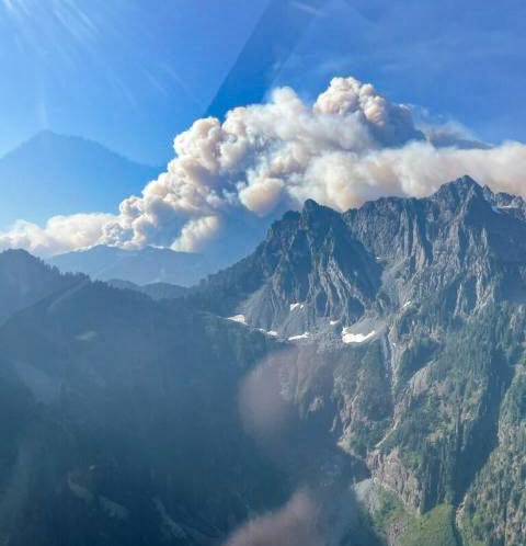
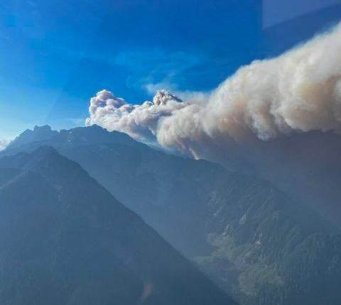
The Bolt Creek Fire near Skykomish is growing rapidly
Updated 8:50 a.m. PDT Sept. 11, 2022
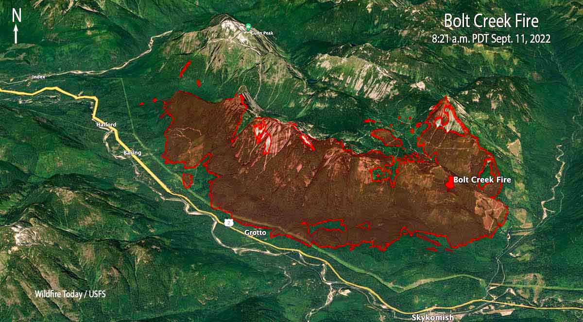
Bolt Creek Fire, mapped by a fixed wing aircraft at 8:21 pm Sept. 10, 2022
The Bolt Creek Fire 42 miles north-northeast of Seattle is producing smoke that is moving into Everett and Bellingham. The fire spread eight miles to the northwest after it started Saturday near Skykomish off US Highway 2. So far it has remained north of the highway as it burned past Grotto and Baring. A US Forest Service mapping flight Saturday night determined it had blackened about 7,660 acres and was 3 miles southeast of Index. This data from a fixed wing aircraft is much more accurate than some of the maps being posted on social media.
To see all articles on Wildfire Today about the Bolt Creek Fire, including the most recent, click HERE.
An 18-mile corridor of Highway 2 remains closed and evacuations are in effect. Snohomish County has the details.
This kind of wildfire activity is exceptionally rare for the western slopes of the central Cascades in Washington.
Satellite photo, Bolt Creek (on the north) and Cedar Creek fires Sept. 10, 2022. Processed by Pierre Markuse.
Two hikers that were on the mountain had a harrowing escape from the fire. They called 911 and were told it was too dangerous to rescue them by helicopter, but eventually after scrambling down steep terrain they made it out of danger. (Update, Sept. 13, 2022: the hikers documented their escape from the fire.)
3:47 p.m. PDT Sept. 10, 2022
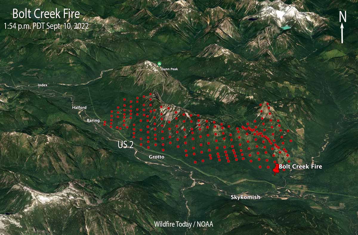
The red dots represent heat detected by a satellite on the Bolt Creek Fire near Skykomish, Washington at 1:54 p.m. PDT September 10, 2022. The extent of heat displayed may be exaggerated. The fire, at that time, may not have been as large as depicted here.
Several wildfires are pushing smoke into western Oregon and Washington. The Bolt Creek Fire, which started Saturday in northwest Washington near Skykomish off US Highway 2 is growing very quickly. It is producing a great deal of smoke blowing to the northwest toward Everett and Bellingham.
Bolt Creek Fire, September 10, 2022. Washington State DNR.
Our very, very rough estimate of the size, based on the imprecise satellite heat data, is that the Bolt Creek Fire had burned more than 2,500 acres by 1:54 p.m. PDT Saturday.
Satellite photo showing smoke from fires in Washington and Oregon, 2:21 PDT Sept. 10, 2022.
A section of Highway 2 is closed.
The US 2 closure now extends from milepost 31.7 (east of Zeke’s Drive In and Gold Bar) to milepost 49 (east end of Skykomish). The road is only open to people evacuating. Please continue to monitor @wspd7pio, @kingcosoPIO and @waDNR_fire for evacuation/fire info. #BoltCreekFire
Snohomish County has evacuation information about the Bolt Creek Fire.
A fire south of Mount Rainier National Park, the Goat Rocks Fire, is also producing smoke, but it is heading generally west to the Centralia area. As of Friday it had burned about 1,500 acres.
The smoke from a very large fire that has been burning since August 1 in west-central Oregon, the Cedar Creek Fire, is sending smoke into Washington. The Washington State DNR said today that smoke from that 35,000-acre fire is being lofted to higher altitudes and is not expected to contribute significantly to further reductions in air quality at ground level. It will actually help keep temperatures down a few degrees Saturday afternoon, they said, and limit the minimum relative humidity values experienced in the Puget Lowlands.
Bolt Creek Fire, September 10, 2022. Washington State DNR.
With 35 large uncontained wildfires currently burning in the United States, and many, many more in various categories, we can’t report extensively on all of them, so today we will take a slice of geography and look briefly at seven fires spreading in the Central Idaho area, and extend it just a bit into Oregon and Montana.
Moose (Idaho)
The largest of these seven fires is the Moose, which has been chewing through eastern Idaho since July 17. As far as the cause, the Salmon National Forest says, after almost two months, it is “human caused,” which only eliminates the causes of volcano and lightning. Nine structures have been destroyed. On Friday 650 personnel are assigned to the 125,000-acre blaze which is 5 miles northwest of Salmon, ID. A satellite overflight Friday afternoon only found large heat sources in the southeast portion and that is where an additional 15,000 acres burned Wednesday night, prompting evacuations near Salmon.
Crews reengaged the fire and began preparing new contingency lines along the west edge of the city. Several water pumps, five log decks, and some portable water storage tanks (nicknamed pumpkins because of their shape and color) were destroyed Wednesday. No firefighters were injured. Nearly 500 acres of the city’s Municipal Watershed burned that night, something the various incident management teams had been trying to protect since July.
Cooler temperatures, higher relative humidity, and thick smoke contributed to minimal fire behavior across the fire Thursday.
Indian Ridge (Idaho)
Northwest of the Moose Fire near the Montana border is the lightning-caused 8,670-acre Indian Ridge Fire on the Bitterroot National Forest. It is in the Selway-Bitterroot Wilderness 30 miles southwest of Darby, Montana. The fire has been active this week primarily along the western and northern flanks and north of Indian Creek as it burns through steep, rugged, remote terrain with heavy surface fuels and dead standing timber.
Indian Ridge Fire the night of August 18, 2022. InciWeb.
The fire is not being fully suppressed. Their daily reporting says, “Fire managers are utilizing a point protection strategy to prevent any critical wilderness infrastructure from being negatively impacted by the fire.”
Dismal and Patrol Point
These two fires are very close to merging after significant growth since September 6, and combined have burned an estimated 23,000 acres. They are about 50 miles northwest of Salmon, Idaho. Smoke and the unavailability of infrared mapping aircraft have made it difficult to determine the current perimeters, but there is a lot of new burned acreage between the two fires. Recent low humidity and strong winds are in part responsible for the recent growth.
Areas that fire managers intend to protect include Cold Meadows Guard Station, Root Ranch, and Lantz Bar.
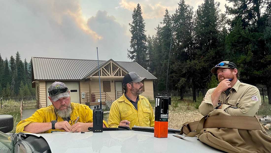
Fire personnel on the Williams Creek Fire in Idaho. InciWeb, posted 9-8-2022.
Williams Creek
The 11,881-acre fire is 5 miles west of Orogrande, near Wildhorse Lake, 7 miles southwest of Elk City, and 8 miles north-northwest of Dixie.
“Resources will continue to engage the fire in Orogrande and the Crooked River corridor, addressing and extinguishing hot spots and conducting damage assessments,” said a September 9 update from the Incident Management Team. “The fire and associated winds did impact structures and outbuildings; crews are still assessing the extent of the damage. Fallen trees, burned snags, and downed power lines continue to present safety hazards.”
Double Creek (Oregon)
The 137,000-acre lightning-caused Double Creek Fire is in Oregon just west of the Idaho border. It has burned to the Snake River in the Pittsburg Landing area. A River Group has been established to assess and protect structures along the waterway. The fire is being fully suppressed and crews are looking for locations to establish the control line farther from Lower Imnaha Road where topography allows. Two structures have been destroyed.
Trail Ridge (Montana)
The 13,000-acre Trail Ridge fire is on the Beaverhead-Deerlodge National Forest in Western Montana about 5 miles east of the Idaho Border and 4 miles southeast of Sula, MT. The cooler weather experienced Thursday and Friday was helpful in slowing the spread of the fire and decreasing the severity of fire behavior. It is burning above 7,000 feet elevation near the Continental Divide and there is no current or expected threat to private land and property. It is not being fully suppressed.