Precipitation reduces wildfire smoke in the central U.S.

Above: Snow cover in the United States, November 18, 2016. The Weather Channel.

Precipitation in the northwest quarter of the United States this week has put even more of a damper on the occurrence of wildfires, the execution of prescribed fires, and agricultural burning.

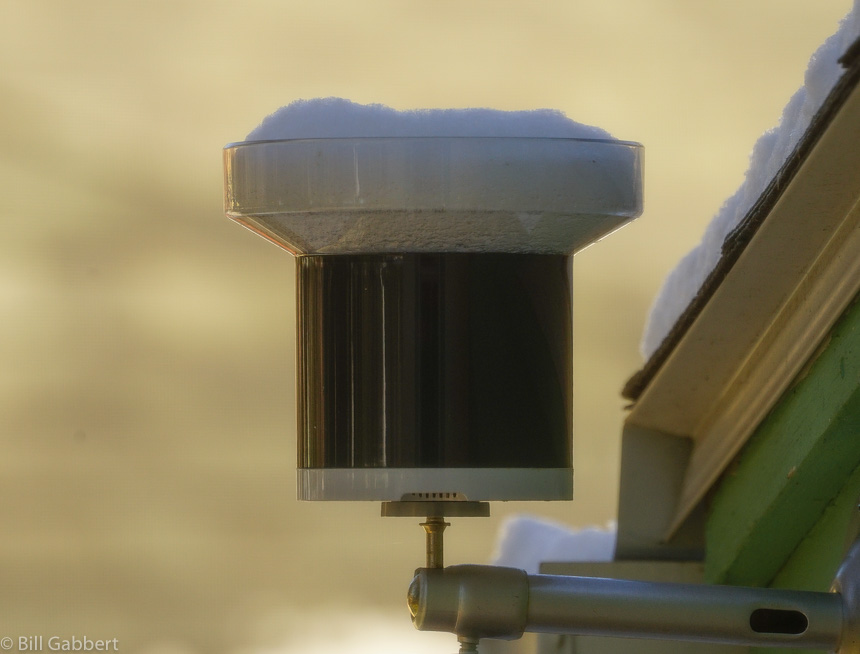
After weeks of warm, dry weather the Black Hills finally received a little precipitation over the last 24 hours. I won’t know the exact amount at my house until the snow in the rain gauge melts, but there was an inch or two of the white stuff on the ground. Today is sunny with a high of 32 predicted, so maybe it will trickle through the tipping bucket this afternoon.
snow rain gauge
Snow captured by my rain gauge since Thursday afternoon. Photo at 11 a.m. MT November 18, 2016 by Bill Gabbert.

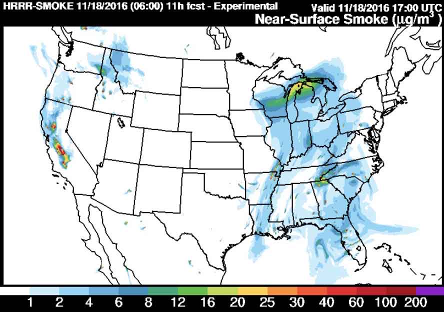
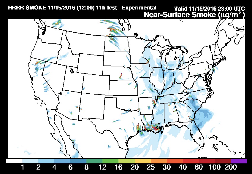
Small amounts of precipitation in southern Saskatchewan may be the reason smoke from that area is no longer immigrating into the United States, as you can see in the two maps below. The first one was the smoke forecast for November 15 and the one after that is for today, November 18.
wildfire smoke forecast
Prediction for the distribution of smoke from wildfires at 6 p.m. ET, November 15, 2016. Produced at 7 a.m. ET November 15.
wildfire smoke forecast
Forecast for wildfire smoke at 6 p.m. ET November 18, 2016, created at 1 a.m. ET November 18, 2016.

However, prescribed fires, wildfires, or agricultural burning in Louisiana, Arkansas, and eastern Texas are still producing large quantities of smoke that at times moves north into the midwest.

No rain is predicted until the middle of next week for the areas where wildfires are smoking out the residents in some areas of Tennessee, North Carolina, Georgia, and South Carolina.
24 hour precipitation
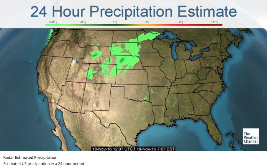
Accumulated precipitation estimated by radar over the 24 hours before 7:07 a.m. ET November 18, 2016.


Wildfire potential, November through February

On November 1 the Predictive Services section at the National Interagency Fire Center issued their Wildland Fire Potential Outlook for November through February. The data represents the cumulative forecasts of the ten Geographic Area Predictive Services Units and the National Predictive Services Unit.

If their predictions are correct, firefighters in the southeast and in southern California could see significant wildfire activity in November and December.

wildfire potential november

Scroll down to see additional wildfire potential maps, the drought monitor, and the 90-day temperature and precipitation outlooks, but immediately below are highlights from the wildfire potential outlook.

****

November significant wildland fire potential is generally very minimal throughout the northern tier of the U.S. as conditions transition out of normal fire season. Areas of the Great Basin and Rocky Mountains that are currently seeing increased levels of fire activity are likely to see much of that activity diminish and transition to out of season conditions through early November.

Exceptions will continue in Southern California where long term drought is still in place. Conditions in this area will slowly transition to normal from north to south through the Outlook period. Normal implies a significant reduction in fire activity, but some fires should still be expected. Also, the southeastern U.S. will continue to see a large area of above normal significant fire potential for November and December that will slowly transition back to normal through the Outlook period as well. This condition is also largely due to long term drought that is going to be exacerbated by dry leaf litter falling on top of already dry fuels and also occasional dry and windy periods. For the southern Plains there is a plentiful grass crop that presents the potential for occasional dry and windy periods to increase fire activity.

Normal winter conditions will prevail across the U.S. in January and February. There will be occasional periods of increased fire activity, but these will be infrequent and difficult to predict accurately. During this outlook period winter precipitation and snowpack development will be a critical situation to monitor as the 2017 fire season becomes the focus of many fire managers.

****

wildfire potential december

wildfire potential january february

Continue reading “Wildfire potential, November through February”

Rainfall in western states slows wildfire season in many areas

Rainfall last 2 weeks washington oregon
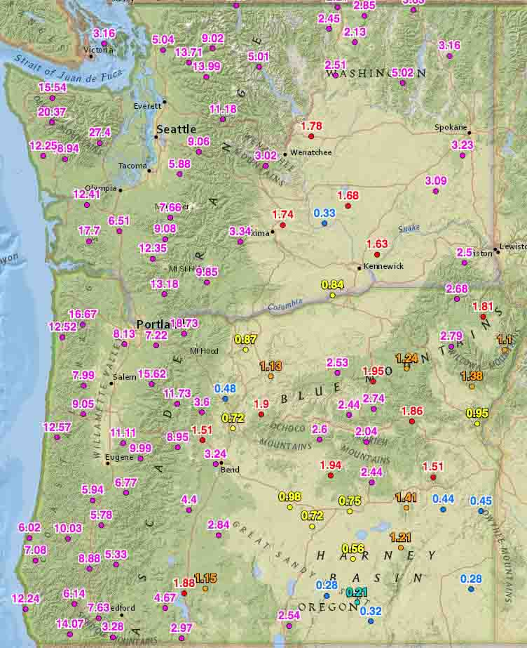
Rainfall last 2 weeks, Washington and Oregon

Rainfall over the last two weeks has slowed or in some cases, ended the wildfire season in some areas.

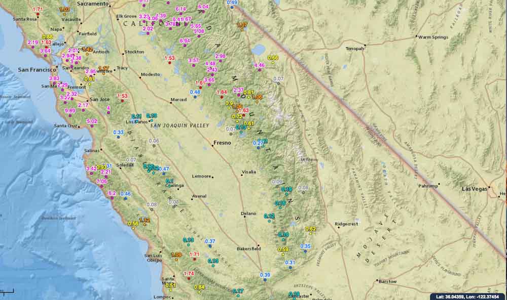
On October 19 we ran the numbers for the accumulated precipitation for the last 14 days in the western states. These maps show amounts that exceeded 0.05 inches at some of the Interagency Remote Automatic Weather Stations (RAWS).

Washington, Oregon, and northern California have received a good soaking and I would imagine that local fire officials may be declaring an end to the fire season. Of course this is not unusual for these areas this time of the year, and some locations had already seen their season end. But what IS unusual, is the high amount of moisture that occurred in just two weeks.

You can click on the images to see larger versions.

Rainfall last 2 weeks, northern California
Rainfall last 2 weeks central California
Rainfall last 2 weeks, central California

Continue to see maps for the other western states.
Continue reading “Rainfall in western states slows wildfire season in many areas”

Wildfire potential, October through January

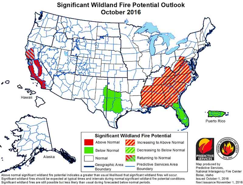
On October 1 the Predictive Services section at the National Interagency Fire Center issued their Wildland Fire Potential Outlook for October through January. The data represents the cumulative forecasts of the ten Geographic Area Predictive Services Units and the National Predictive Services Unit.

If their predictions are correct, firefighters in the mountains of central and southern California could be busy through November, at least, while most of the Southeast is coming into what could be a very active fall fire season.

wildfire potential

Scroll down to see 6 to 14-day temperature and precipitation outlooks, and Red Flag Warnings for October 2, but immediately below are highlights from the wildfire potential outlook.

****

“October represents a significant shift in fire activity in the United States. Shorter days, cooler nights and generally moister conditions reduce wildfire activity across the northern tier of the U.S., taking much of this area out of season or at least to very low fire activity conditions.

“October does represent the beginning of the primary time of concern for offshore flow across California. These dry windy conditions can lead to very significant fire events in areas with high populations. This year the forecasts indicate that offshore wind events may be less frequent than usual. However during even light wind periods fires will occur and they will have the potential to spread extremely quickly with extreme fire behavior. Fuels continue to be very dry in California due to long term drought and increased vegetation stress and mortality. Under windy conditions these fuels will become extremely volatile and can support extreme fire behavior.

“October also marks the start of the fall fire season across the eastern U.S. Leaf drop begins and adds a new dry layer of fuel. In seasons such as this one where leaf drop occurs on already dry fuels, fire activity can be amplified. Expect this to lead to increased initial attack activity and probably a slight increase in large fires. Fire activity occurs year round in the southeastern U.S. so the most likely scenario is to see an increase in frequency and the potential for more control problems than usual on fires this fall.

Continue reading “Wildfire potential, October through January”

Revisions to the National Fire Danger Rating System

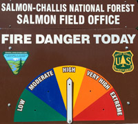
fire dangerThe National Fire Danger Rating System tracks weather events through their effects on live and dead fuels and adjusts them accordingly based on forecasted weather. The most visible product of the system, which is used by most large land management agencies in the United States, is the predicted fire danger, often expressed as adjectives ranging from Low to Extreme.

The NFDRS was first released for general use in 1972 and was subsequently revised in 1978 and 1988. Work on another revision began in 2000 and is nearing completion. Reportedly this next version is much simpler and more automated than its predecessors and it represents a vast improvement in fire potential assessment capabilities.

Three major changes will be:

  • The Fosberg Dead Fuel Moisture Model will be replaced with the Nelson Dead Fuel Moisture Model.
  • The Burgan Live Fuel Moisture Model will be replaced with the Growing Season Index-based live fuel moistures.
  • The number of fuel models in the NFDRS will be reduced from 40 to 5.

Jon Wallace, a member of the team rolling out and implementing the new system described the transition in an email today:

“The system is expected to be back from contracting and thus complete on November 1st of 2016. After the first of the year we’re going to begin training of Subject Matter Expert groups located within each geographic area, and when that training is complete we will open the system up for all users.  We had to wait to conduct this training until the system was fully functional.

“As you can imagine, there is going to be a learning curve for the user community and these Subject Matter Expert groups are going to help us get through that curve within their respective geographic area.

“All members of the user community will be able to see the new NFDRS2016, as well as the 1978 and 1988 NFDRS models during the spring of 2017.  This will allow them to work with the subject matter expert groups to set up NFDRS parameters prior to the Summer of 2017 fire season.  They will then be able to compare the outputs of the new system to what they are used to seeing in the older versions of NFDRS.

“This side by side comparison will be available to users through the 2018 fire season, at which time we will re-evaluate the need to continue support of the old systems.”